Northern lights in Vermont tonight
The aurora reaches Vermont at about Kp 6.2 in the far north of the state and Kp 6.6 at its southern edge. SWPC's highest forecast Kp over the next three days is 3+, in the 00-03 UTC block on Thu, Sep 24. Not tonight. The forecast Kp of 2- is well below what it takes for the aurora to reach this far south.
From NOAA’s Space Weather Prediction Center, read Sep 21, 01:36 UTC.
The oval right now
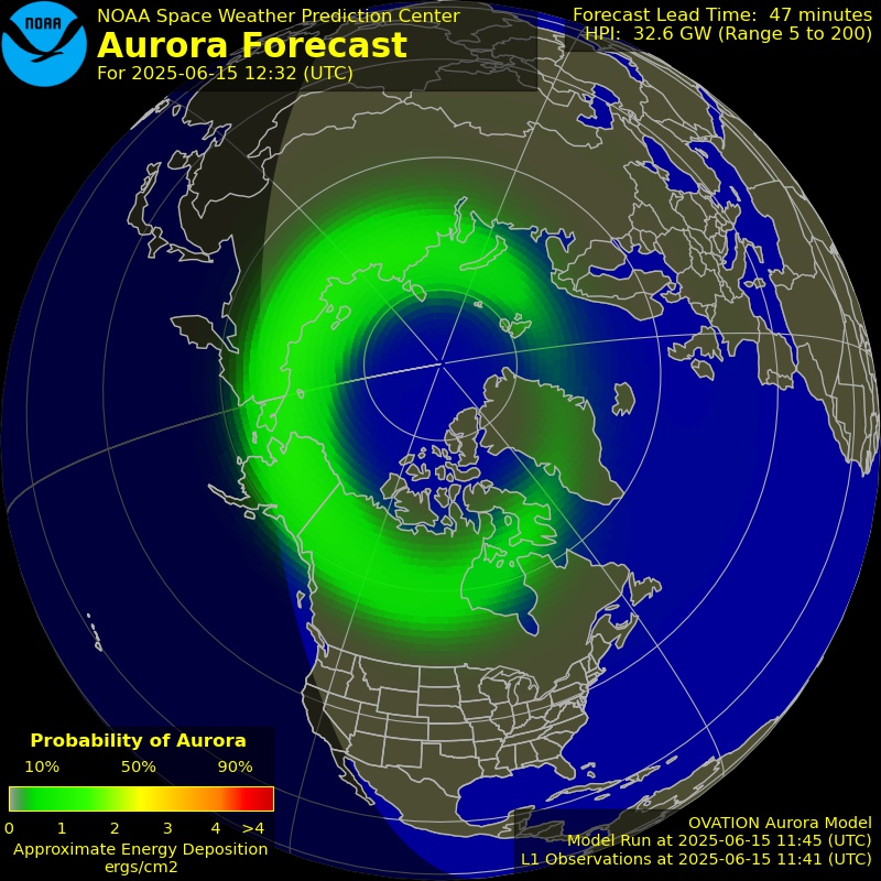
NOAA’s OVATION model: the chance of aurora overhead 30 to 90 minutes from now, valid Sep 21, 02:40 UTC. Green is a low chance, red a high one.
Rain and snow mean cloud, and cloud is the last thing between a forecast aurora and the sky you are standing under. Each town page carries that town’s own sky cover forecast for the dark hours.
Open the live map with the aurora forecast
Aurora forecast from NOAA’s Space Weather Prediction Center. Original at SWPC
Tonight at Beebe Plain
The most poleward town in Vermont with a page, and the first place in the state an aurora reaches. Cloud cover is on each town’s own page.
No tonight
Not tonight. The forecast Kp of 2- is well below what it takes for the aurora to reach this far south.
- The aurora reaches this place at about Kp 6.2, which is 54 degrees geomagnetic latitude on NOAA's storm scales.
- SWPC forecasts a highest Kp of 2- (1.67) during tonight's dark hours: quiet.
- The moon is waxing gibbous, 70% lit, and up for part of the dark hours.
Towns best placed in Vermont
The 24 most poleward of the 117 towns in Vermont with a page. Each page gives tonight’s chance there, the darkness, the moon and that town’s own cloud forecast.
- Beebe PlainOrleans County · population 854 · 54.2° geomagneticKp 6.2
- Derby LineOrleans County · population 651 · 54.2° geomagneticKp 6.2
- RichfordFranklin County · population 1,361 · 54.2° geomagneticKp 6.2
- North TroyOrleans County · population 594 · 54.2° geomagneticKp 6.2
- HollandOrleans County · population 610 · 54.2° geomagneticKp 6.2
- Derby CenterOrleans County · population 576 · 54.1° geomagneticKp 6.2
- NewportOrleans County · population 4,442 · 54.1° geomagneticKp 6.2
- SwantonFranklin County · population 2,370 · 54.1° geomagneticKp 6.2
- Enosburg FallsFranklin County · population 1,305 · 54.1° geomagneticKp 6.2
- MontgomeryFranklin County · population 1,195 · 54.1° geomagneticKp 6.2
- North HeroGrand Isle County · population 793 · 54.0° geomagneticKp 6.2
- OrleansOrleans County · population 818 · 54.0° geomagneticKp 6.2
- Island PondEssex County · population 821 · 54.0° geomagneticKp 6.2
- Saint AlbansFranklin County · population 6,918 · 54.0° geomagneticKp 6.2
- BartonOrleans County · population 700 · 53.9° geomagneticKp 6.2
- JeffersonvilleLamoille County · population 753 · 53.8° geomagneticKp 6.2
- MiltonChittenden County · population 1,861 · 53.8° geomagneticKp 6.2
- JohnsonLamoille County · population 1,451 · 53.8° geomagneticKp 6.2
- Hyde ParkLamoille County · population 492 · 53.8° geomagneticKp 6.2
- GuildhallEssex County · population 256 · 53.8° geomagneticKp 6.2
- MorrisvilleLamoille County · population 2,040 · 53.8° geomagneticKp 6.2
- MorristownLamoille County · population 5,653 · 53.8° geomagneticKp 6.2
- ColchesterChittenden County · population 16,986 · 53.7° geomagneticKp 6.3
- LyndonvilleCaledonia County · population 1,190 · 53.7° geomagneticKp 6.3
Every town in Vermont with a page
117 towns at 48 degrees geomagnetic latitude or higher, which a strong storm reaches. The figure after each is the Kp it takes there.
A
B
- Barre Kp 6.3
- Barton Kp 6.2
- Beebe Plain Kp 6.2
- Bellows Falls Kp 6.5
- Bennington Kp 6.6
- Bethel Kp 6.4
- Bradford Kp 6.4
- Brandon Kp 6.4
- Brattleboro Kp 6.6
- Bridport Kp 6.4
- Bristol Kp 6.3
- Burlington Kp 6.3
C
- Castleton Kp 6.4
- Charlotte Kp 6.3
- Chelsea Kp 6.4
- Chester Kp 6.5
- Chittenden Kp 6.4
- Clarendon Kp 6.5
- Colchester Kp 6.3
D
- Danby Kp 6.5
- Derby Center Kp 6.2
- Derby Line Kp 6.2
- Dover Kp 6.6
E
- East Barre Kp 6.3
- Enosburg Falls Kp 6.2
- Essex Junction Kp 6.3
F
- Fair Haven Kp 6.4
- Ferrisburgh Kp 6.3
G
- Graniteville Kp 6.3
- Guildhall Kp 6.2
H
I
- Island Pond Kp 6.2
J
- Jamaica Kp 6.5
- Jeffersonville Kp 6.2
- Jericho Kp 6.3
- Johnson Kp 6.2
L
- Leicester Kp 6.4
- Lincoln Kp 6.3
- Londonderry Kp 6.5
- Ludlow Kp 6.5
- Lunenburg Kp 6.3
- Lyndon Kp 6.3
- Lyndonville Kp 6.3
M
- Manchester Kp 6.5
- Manchester Center Kp 6.5
- Mendon Kp 6.4
- Middlebury (village) Kp 6.4
- Middlesex Kp 6.3
- Milton Kp 6.2
- Montgomery Kp 6.2
- Montpelier Kp 6.3
- Moretown Kp 6.3
- Morristown Kp 6.2
- Morrisville Kp 6.2
- Mount Holly Kp 6.5
N
- Newfane Kp 6.6
- Newport Kp 6.2
- North Bennington Kp 6.6
- North Hero Kp 6.2
- North Springfield Kp 6.5
- North Troy Kp 6.2
- Northfield Kp 6.3
- Norwich Kp 6.4
O
- Orleans Kp 6.2
P
Q
- Quechee Kp 6.4
R
- Randolph Kp 6.4
- Richford Kp 6.2
- Richmond Kp 6.3
- Ripton Kp 6.4
- Rockingham Kp 6.5
- Rupert Kp 6.5
- Rutland Kp 6.4
S
- Saint Albans Kp 6.2
- Saint Johnsbury Kp 6.3
- Salisbury Kp 6.4
- Saxtons River Kp 6.5
- Shelburne Kp 6.3
- South Barre Kp 6.3
- South Burlington Kp 6.3
- South Royalton Kp 6.4
- South Shaftsbury Kp 6.6
- Springfield Kp 6.5
- St Johnsbury Kp 6.3
- Starksboro Kp 6.3
- Stowe Kp 6.3
- Swanton Kp 6.2
T
- Townshend Kp 6.6
V
- Vergennes Kp 6.3
W
- Wallingford Kp 6.5
- Washington Kp 6.3
- Waterbury Kp 6.3
- Websterville Kp 6.3
- West Brattleboro Kp 6.6
- West Pawlet Kp 6.5
- West Rutland Kp 6.4
- Weston Kp 6.5
- White River Junction Kp 6.4
- White River Junction VA Medical Center Kp 6.6
- Wilder Kp 6.4
- Williamstown Kp 6.3
- Williston Kp 6.3
- Windsor Kp 6.5
- Winooski Kp 6.3
- Woodstock Kp 6.4
How far south each storm level reaches
NOAA’s space weather scales state the geomagnetic latitude each level of geomagnetic storm reaches, and the places its aurora has been seen from. The geographic latitudes are those lines converted with the geomagnetic dipole; the aurora sits low on the northern horizon there, and overhead far poleward of it.
| Storm | Geomagnetic | Central US | Eastern US | Northern Europe | NOAA says the aurora |
|---|---|---|---|---|---|
| G1 MinorKp 5 | 60° | 52°N | 51°N | 61°N | commonly visible at high latitudes: northern Michigan and Maine |
| G2 ModerateKp 6 | 55° | 47°N | 46°N | 56°N | has been seen as low as New York and Idaho |
| G3 StrongKp 7 | 50° | 42°N | 41°N | 51°N | has been seen as low as Illinois and Oregon |
| G4 SevereKp 8 | 45° | 37°N | 36°N | 45°N | has been seen as low as Alabama and northern California |
| G5 ExtremeKp 9 | 40° | 32°N | 31°N | 40°N | has been seen as low as Florida and southern Texas |
Source: NOAA space weather scales, swpc.noaa.gov/noaa-scales-explanation. Below Kp 5 the oval contracts more slowly; this section runs the line from 66 degrees geomagnetic at Kp 0 to the scale’s 60 degrees at Kp 5.
Kp by 3-hour block
SWPC’s planetary K index forecast, three days ahead. Kp is a single number for the whole planet, from magnetometers around the world, on a scale of 0 to 9 in thirds.
| Block (UTC) | Kp | Level | Seen from | Central US |
|---|---|---|---|---|
| 1.33 | Quiet | 64° geomag. | 56°N | |
| 1.33 | Quiet | 64° geomag. | 56°N | |
| 1.67 | Quiet | 64° geomag. | 56°N | |
| 1.67 | Quiet | 64° geomag. | 56°N | |
| 1.33 | Quiet | 64° geomag. | 56°N | |
| 1.33 | Quiet | 64° geomag. | 56°N | |
| 1.33 | Quiet | 64° geomag. | 56°N | |
| 1.33 | Quiet | 64° geomag. | 56°N | |
| 1.67 | Quiet | 64° geomag. | 56°N | |
| 2.00 | Quiet | 64° geomag. | 55°N | |
| 1.67 | Quiet | 64° geomag. | 56°N | |
| 1.33 | Quiet | 64° geomag. | 56°N | |
| 0.67 | Quiet | 65° geomag. | 57°N | |
| 0.67 | Quiet | 65° geomag. | 57°N | |
| 1.67 | Quiet | 64° geomag. | 56°N | |
| 1.67 | Quiet | 64° geomag. | 56°N | |
| 1.67 | Quiet | 64° geomag. | 56°N | |
| 2.00 | Quiet | 64° geomag. | 55°N | |
| 1.67 | Quiet | 64° geomag. | 56°N | |
| 1.33 | Quiet | 64° geomag. | 56°N | |
| 0.67 | Quiet | 65° geomag. | 57°N | |
| 0.67 | Quiet | 65° geomag. | 57°N | |
| 1.67 | Quiet | 64° geomag. | 56°N | |
| 1.67 | Quiet | 64° geomag. | 56°N |
The forecast is for the planet, not for your sky. A block at Kp 5 means the field is disturbed enough for the aurora to reach 60 degrees geomagnetic somewhere along the night side; whether you see it depends on being on the night side, on darkness, and on the clouds.
Other states with aurora pages
- Alaska
- Colorado
- Connecticut
- Delaware
- District of Columbia
- Idaho
- Illinois
- Indiana
- Iowa
- Kansas
- Kentucky
- Maine
- Maryland
- Massachusetts
- Michigan
- Minnesota
- Missouri
- Montana
- Nebraska
- Nevada
- New Hampshire
- New Jersey
- New York
- North Dakota
- Ohio
- Oregon
- Pennsylvania
- Rhode Island
- South Dakota
- Utah
- Virginia
- Washington
- West Virginia
- Wisconsin
- Wyoming
What this means
Each place is placed by its geomagnetic latitude, measured from the geomagnetic dipole pole, and compared with the reach NOAA states for each storm level on its space weather scales: G1 (Kp 5) about 60 degrees geomagnetic, G2 55, G3 50, G4 45, G5 (Kp 9) 40. Reading that backwards gives the Kp a place needs. Below Kp 5 the oval contracts more slowly and the line runs from 66 degrees at Kp 0 to 60 at Kp 5.
The forecasts have different horizons and the pages keep them apart: OVATION is the only thing that knows whether an aurora is out now, and it reaches 30 to 90 minutes ahead; the planetary Kp forecast runs three days; the 27-day outlook names likely active days and is not a forecast of any one night. None of them knows the clouds, which is why a town page reads its own forecast for those.
Sources
From NOAA’s Space Weather Prediction Center: the OVATION aurora forecast, the planetary K index forecast, the 3-day forecast, the 27-day outlook, its watches, warnings and alerts, and the real-time solar wind. Read Sep 21, 01:36 UTC.