Northern lights in Oregon tonight
The aurora reaches Oregon at about Kp 6.6 in the far north of the state and Kp 7.4 at its southern edge. SWPC's highest forecast Kp over the next three days is 2, in the 03-06 UTC block on Mon, Sep 21. Not tonight. The forecast Kp of 2 is well below what it takes for the aurora to reach this far south.
From NOAA’s Space Weather Prediction Center, read Sep 20, 18:08 UTC.
The oval right now
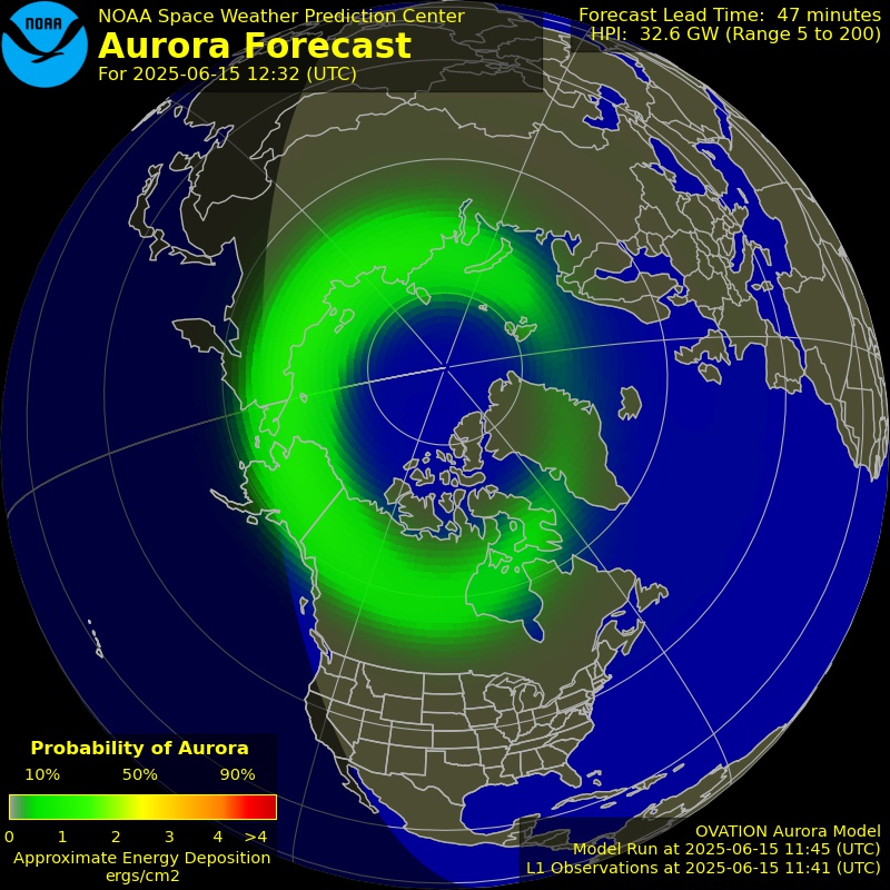
NOAA’s OVATION model: the chance of aurora overhead 30 to 90 minutes from now, valid Sep 20, 19:10 UTC. Green is a low chance, red a high one.
Rain and snow mean cloud, and cloud is the last thing between a forecast aurora and the sky you are standing under. Each town page carries that town’s own sky cover forecast for the dark hours.
Open the live map with the aurora forecast
Aurora forecast from NOAA’s Space Weather Prediction Center. Original at SWPC
Tonight at Milton-Freewater
The most poleward town in Oregon with a page, and the first place in the state an aurora reaches. Cloud cover is on each town’s own page.
No tonight
Not tonight. The forecast Kp of 2 is well below what it takes for the aurora to reach this far south.
- The aurora reaches this place at about Kp 6.6, which is 52 degrees geomagnetic latitude on NOAA's storm scales.
- SWPC forecasts a highest Kp of 2 (2.00) during tonight's dark hours: quiet.
- The moon is waxing gibbous, 71% lit, and up for part of the dark hours.
Towns best placed in Oregon
The 24 most poleward of the 230 towns in Oregon with a page. Each page gives tonight’s chance there, the darkness, the moon and that town’s own cloud forecast.
- Milton-FreewaterUmatilla County · population 7,035 · 51.9° geomagneticKp 6.6
- WestonUmatilla County · population 647 · 51.8° geomagneticKp 6.6
- AthenaUmatilla County · population 1,140 · 51.8° geomagneticKp 6.6
- UmatillaUmatilla County · population 7,009 · 51.8° geomagneticKp 6.6
- IrrigonMorrow County · population 1,800 · 51.7° geomagneticKp 6.7
- HermistonUmatilla County · population 17,201 · 51.7° geomagneticKp 6.7
- WallowaWallowa County · population 795 · 51.7° geomagneticKp 6.7
- StanfieldUmatilla County · population 2,082 · 51.6° geomagneticKp 6.7
- BoardmanMorrow County · population 3,354 · 51.6° geomagneticKp 6.7
- EchoUmatilla County · population 702 · 51.6° geomagneticKp 6.7
- MissionUmatilla County · population 1,037 · 51.6° geomagneticKp 6.7
- ElginUnion County · population 1,732 · 51.6° geomagneticKp 6.7
- PendletonUmatilla County · population 16,881 · 51.6° geomagneticKp 6.7
- EnterpriseWallowa County · population 1,893 · 51.5° geomagneticKp 6.7
- JosephWallowa County · population 1,063 · 51.5° geomagneticKp 6.7
- ArlingtonGilliam County · population 583 · 51.5° geomagneticKp 6.7
- RainierColumbia County · population 1,920 · 51.5° geomagneticKp 6.7
- ClatskanieColumbia County · population 1,759 · 51.4° geomagneticKp 6.7
- AstoriaClatsop County · population 9,626 · 51.4° geomagneticKp 6.7
- HammondClatsop County · population 589 · 51.4° geomagneticKp 6.7
- Pilot RockUmatilla County · population 1,513 · 51.4° geomagneticKp 6.7
- WarrentonClatsop County · population 5,282 · 51.4° geomagneticKp 6.7
- Island CityUnion County · population 1,005 · 51.4° geomagneticKp 6.7
- CoveUnion County · population 554 · 51.4° geomagneticKp 6.7
Every town in Oregon with a page
230 towns at 48 degrees geomagnetic latitude or higher, which a strong storm reaches. The figure after each is the Kp it takes there.
A
- Adair Village Kp 7
- Agate Beach Kp 7
- Albany Kp 7
- Aloha Kp 6.8
- Amity Kp 6.9
- Arlington Kp 6.7
- Astoria Kp 6.7
- Athena Kp 6.6
- Aumsville Kp 7
- Aurora Kp 6.9
B
- Baker City Kp 6.8
- Bandon Kp 7.3
- Banks Kp 6.8
- Barview Kp 7.3
- Bay City Kp 6.8
- Bayside Gardens Kp 6.8
- Beavercreek Kp 6.9
- Beaverton Kp 6.8
- Bend Kp 7.1
- Bethany Kp 6.8
- Boardman Kp 6.7
- Bridgeton Kp 6.8
- Brownsville Kp 7
- Bunker Hill Kp 7.3
- Burns Kp 7.1
C
- Canby Kp 6.9
- Cannon Beach Kp 6.8
- Canyon City Kp 6.9
- Canyonville Kp 7.3
- Carlton Kp 6.9
- Cascade Locks Kp 6.8
- Cedar Hills Kp 6.8
- Cedar Mill Kp 6.8
- Chenoweth Kp 6.8
- Chiloquin Kp 7.4
- Clackamas Kp 6.8
- Clatskanie Kp 6.7
- Coburg Kp 7.1
- Columbia City Kp 6.7
- Condon Kp 6.8
- Coos Bay Kp 7.3
- Coquille Kp 7.3
- Cornelius Kp 6.8
- Corvallis Kp 7
- Cottage Grove Kp 7.2
- Cove Kp 6.7
- Creswell Kp 7.1
- Culp Creek Kp 7.2
- Culver Kp 7
D
- Dallas Kp 6.9
- Damascus Kp 6.8
- Dayton Kp 6.9
- Depoe Bay Kp 7
- Deschutes River Woods Kp 7.1
- Donald Kp 6.9
- Drain Kp 7.2
- Dufur Kp 6.8
- Dundee Kp 6.9
- Dunes City Kp 7.2
- Durham Kp 6.8
E
- Echo Kp 6.7
- Elgin Kp 6.7
- Enterprise Kp 6.7
- Estacada Kp 6.9
- Eugene Kp 7.1
F
- Fairview Kp 6.8
- Falls City Kp 7
- Florence Kp 7.2
- Forest Grove Kp 6.8
- Fossil Kp 6.9
- Four Corners Kp 6.9
G
- Garden Home-Whitford Kp 6.8
- Garibaldi Kp 6.8
- Gaston Kp 6.8
- Gearhart Kp 6.7
- Gervais Kp 6.9
- Gladstone Kp 6.8
- Glasgow Kp 7.3
- Glendale Kp 7.4
- Glide Kp 7.3
- Grand Ronde Kp 6.9
- Green Kp 7.3
- Gresham Kp 6.8
H
- Halsey Kp 7
- Hammond Kp 6.7
- Happy Valley Kp 6.8
- Harrisburg Kp 7.1
- Hayesville Kp 6.9
- Heppner Kp 6.8
- Hermiston Kp 6.7
- Hillsboro Kp 6.8
- Hines Kp 7.1
- Hood River Kp 6.7
- Hubbard Kp 6.9
I
- Independence Kp 7
- Irrigon Kp 6.7
- Island City Kp 6.7
J
- Jefferson Kp 7
- Jennings Lodge Kp 6.8
- John Day Kp 6.9
- Johnson City Kp 6.8
- Joseph Kp 6.7
- Junction City Kp 7.1
K
L
- La Grande Kp 6.7
- La Pine Kp 7.1
- Lacomb Kp 7
- Lafayette Kp 6.9
- Lake Oswego Kp 6.8
- Lakeside Kp 7.2
- Lebanon Kp 7
- Lents Kp 6.8
- Lincoln Beach Kp 7
- Lincoln City Kp 7
- Lookingglass Kp 7.3
- Lowell Kp 7.1
- Lyons Kp 7
M
- Madras Kp 6.9
- Manzanita Kp 6.8
- Maywood Park Kp 6.8
- McMinnville Kp 6.9
- Melrose Kp 7.3
- Metolius Kp 7
- Metzger Kp 6.8
- Mill City Kp 7
- Millersburg Kp 7
- Milton-Freewater Kp 6.6
- Milwaukie Kp 6.8
- Mission Kp 6.7
- Molalla Kp 6.9
- Monmouth Kp 7
- Monroe Kp 7.1
- Moro Kp 6.8
- Mount Angel Kp 6.9
- Mount Hood Village Kp 6.8
- Mount Vernon Kp 6.9
- Mulino Kp 6.9
- Myrtle Creek Kp 7.3
- Myrtle Point Kp 7.3
N
- Netarts Kp 6.9
- Newberg Kp 6.9
- Newport Kp 7
- North Bend Kp 7.3
- North Plains Kp 6.8
- North Portland Kp 6.8
- Nyssa Kp 7
O
- Oak Grove Kp 6.8
- Oak Hills Kp 6.8
- Oakland Kp 7.2
- Oakridge Kp 7.2
- Oatfield Kp 6.8
- Odell Kp 6.8
- Ontario Kp 7
- Oregon City Kp 6.8
P
- Pacific City Kp 6.9
- Pendleton Kp 6.7
- Philomath Kp 7
- Pilot Rock Kp 6.7
- Portland Kp 6.8
- Powers Kp 7.4
- Prairie City Kp 6.9
- Prineville Kp 7
R
- Rainier Kp 6.7
- Raleigh Hills Kp 6.8
- Redmond Kp 7
- Reedsport Kp 7.2
- Riddle Kp 7.3
- Rockaway Beach Kp 6.8
- Rockcreek Kp 6.8
- Rose Lodge Kp 6.9
- Roseburg Kp 7.3
- Roseburg North Kp 7.3
S
- Saint Helens Kp 6.8
- Salem Kp 6.9
- Sandy Kp 6.8
- Scappoose Kp 6.8
- Scio Kp 7
- Seaside Kp 6.8
- Shady Cove Kp 7.4
- Sheridan Kp 6.9
- Sherwood Kp 6.9
- Siletz Kp 7
- Silverton Kp 6.9
- Sisters Kp 7
- South Lebanon Kp 7
- Springfield Kp 7.1
- Stafford Kp 6.8
- Stanfield Kp 6.7
- Stayton Kp 7
- Sublimity Kp 7
- Sunriver Kp 7.1
- Sutherlin Kp 7.2
- Sweet Home Kp 7
T
- Tangent Kp 7
- Terrebonne Kp 7
- The Dalles Kp 6.8
- Three Rivers Kp 7.1
- Tigard Kp 6.8
- Tillamook Kp 6.9
- Toledo Kp 7
- Trail Kp 7.4
- Tri-City Kp 7.3
- Troutdale Kp 6.8
- Tualatin Kp 6.8
- Turner Kp 7
U
V
W
- Waldport Kp 7.1
- Wallowa Kp 6.7
- Warm Springs Kp 6.9
- Warren Kp 6.8
- Warrenton Kp 6.7
- West Haven Kp 6.8
- West Haven-Sylvan Kp 6.8
- West Linn Kp 6.8
- West Slope Kp 6.8
- Weston Kp 6.6
- Willamina Kp 6.9
- Wilsonville Kp 6.9
- Winston Kp 7.3
- Wood Village Kp 6.8
- Woodburn Kp 6.9
Y
How far south each storm level reaches
NOAA’s space weather scales state the geomagnetic latitude each level of geomagnetic storm reaches, and the places its aurora has been seen from. The geographic latitudes are those lines converted with the geomagnetic dipole; the aurora sits low on the northern horizon there, and overhead far poleward of it.
| Storm | Geomagnetic | Central US | Eastern US | Northern Europe | NOAA says the aurora |
|---|---|---|---|---|---|
| G1 MinorKp 5 | 60° | 52°N | 51°N | 61°N | commonly visible at high latitudes: northern Michigan and Maine |
| G2 ModerateKp 6 | 55° | 47°N | 46°N | 56°N | has been seen as low as New York and Idaho |
| G3 StrongKp 7 | 50° | 42°N | 41°N | 51°N | has been seen as low as Illinois and Oregon |
| G4 SevereKp 8 | 45° | 37°N | 36°N | 45°N | has been seen as low as Alabama and northern California |
| G5 ExtremeKp 9 | 40° | 32°N | 31°N | 40°N | has been seen as low as Florida and southern Texas |
Source: NOAA space weather scales, swpc.noaa.gov/noaa-scales-explanation. Below Kp 5 the oval contracts more slowly; this section runs the line from 66 degrees geomagnetic at Kp 0 to the scale’s 60 degrees at Kp 5.
Kp by 3-hour block
SWPC’s planetary K index forecast, three days ahead. Kp is a single number for the whole planet, from magnetometers around the world, on a scale of 0 to 9 in thirds.
| Block (UTC) | Kp | Level | Seen from | Central US |
|---|---|---|---|---|
| 1.33 | Quiet | 64° geomag. | 56°N | |
| 1.33 | Quiet | 64° geomag. | 56°N | |
| 1.67 | Quiet | 64° geomag. | 56°N | |
| 2.00 | Quiet | 64° geomag. | 55°N | |
| 1.67 | Quiet | 64° geomag. | 56°N | |
| 1.33 | Quiet | 64° geomag. | 56°N | |
| 0.67 | Quiet | 65° geomag. | 57°N | |
| 1.33 | Quiet | 64° geomag. | 56°N | |
| 1.33 | Quiet | 64° geomag. | 56°N | |
| 1.67 | Quiet | 64° geomag. | 56°N | |
| 1.67 | Quiet | 64° geomag. | 56°N | |
| 1.33 | Quiet | 64° geomag. | 56°N | |
| 1.33 | Quiet | 64° geomag. | 56°N | |
| 1.33 | Quiet | 64° geomag. | 56°N | |
| 1.33 | Quiet | 64° geomag. | 56°N | |
| 1.33 | Quiet | 64° geomag. | 56°N | |
| 1.67 | Quiet | 64° geomag. | 56°N | |
| 1.67 | Quiet | 64° geomag. | 56°N | |
| 1.67 | Quiet | 64° geomag. | 56°N |
The forecast is for the planet, not for your sky. A block at Kp 5 means the field is disturbed enough for the aurora to reach 60 degrees geomagnetic somewhere along the night side; whether you see it depends on being on the night side, on darkness, and on the clouds.
Other states with aurora pages
- Alaska
- Colorado
- Connecticut
- Delaware
- District of Columbia
- Idaho
- Illinois
- Indiana
- Iowa
- Kansas
- Kentucky
- Maine
- Maryland
- Massachusetts
- Michigan
- Minnesota
- Missouri
- Montana
- Nebraska
- Nevada
- New Hampshire
- New Jersey
- New York
- North Dakota
- Ohio
- Pennsylvania
- Rhode Island
- South Dakota
- Utah
- Vermont
- Virginia
- Washington
- West Virginia
- Wisconsin
- Wyoming
What this means
Each place is placed by its geomagnetic latitude, measured from the geomagnetic dipole pole, and compared with the reach NOAA states for each storm level on its space weather scales: G1 (Kp 5) about 60 degrees geomagnetic, G2 55, G3 50, G4 45, G5 (Kp 9) 40. Reading that backwards gives the Kp a place needs. Below Kp 5 the oval contracts more slowly and the line runs from 66 degrees at Kp 0 to 60 at Kp 5.
The forecasts have different horizons and the pages keep them apart: OVATION is the only thing that knows whether an aurora is out now, and it reaches 30 to 90 minutes ahead; the planetary Kp forecast runs three days; the 27-day outlook names likely active days and is not a forecast of any one night. None of them knows the clouds, which is why a town page reads its own forecast for those.
Sources
From NOAA’s Space Weather Prediction Center: the OVATION aurora forecast, the planetary K index forecast, the 3-day forecast, the 27-day outlook, its watches, warnings and alerts, and the real-time solar wind. Read Sep 20, 18:08 UTC.