Northern lights in Maine tonight
The aurora reaches Maine at about Kp 5.7 in the far north of the state and Kp 6.5 at its southern edge. SWPC's highest forecast Kp over the next three days is 2, in the 03-06 UTC block on Mon, Sep 21. Not tonight. The forecast Kp of 2 is well below what it takes for the aurora to reach this far south.
From NOAA’s Space Weather Prediction Center, read Sep 20, 18:13 UTC.
The oval right now
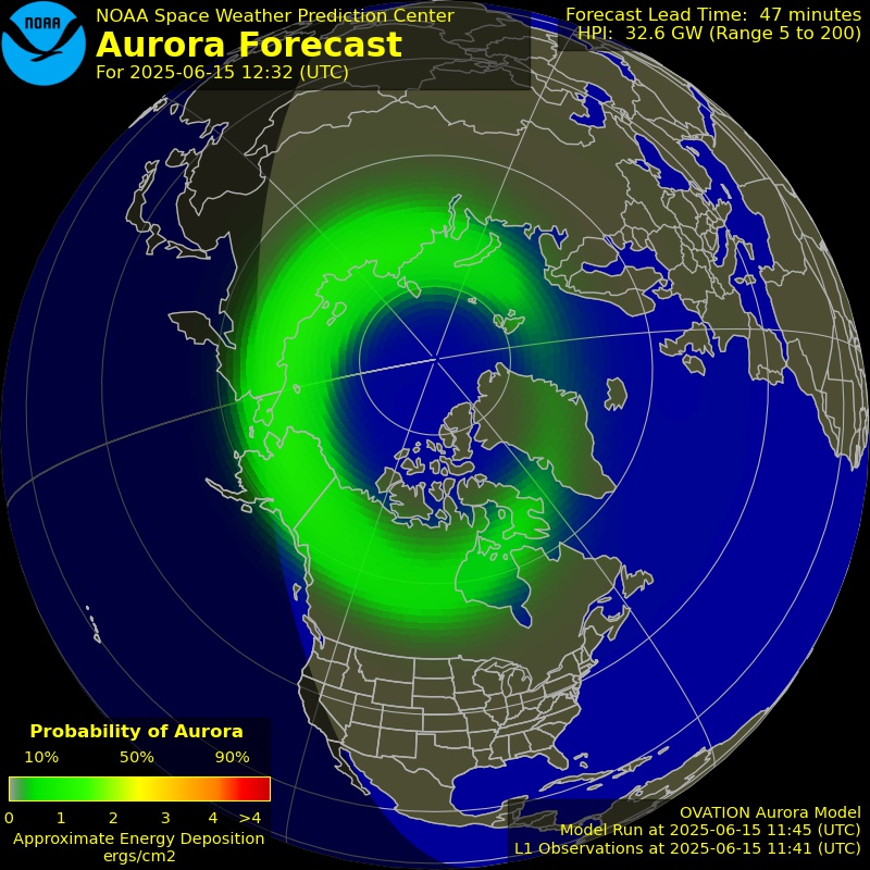
NOAA’s OVATION model: the chance of aurora overhead 30 to 90 minutes from now, valid Sep 20, 19:10 UTC. Green is a low chance, red a high one.
Rain and snow mean cloud, and cloud is the last thing between a forecast aurora and the sky you are standing under. Each town page carries that town’s own sky cover forecast for the dark hours.
Open the live map with the aurora forecast
Aurora forecast from NOAA’s Space Weather Prediction Center. Original at SWPC
Tonight at Madawaska
The most poleward town in Maine with a page, and the first place in the state an aurora reaches. Cloud cover is on each town’s own page.
No tonight
Not tonight. The forecast Kp of 2 is well below what it takes for the aurora to reach this far south.
- The aurora reaches this place at about Kp 5.7, which is 57 degrees geomagnetic latitude on NOAA's storm scales.
- SWPC forecasts a highest Kp of 2 (2.00) during tonight's dark hours: quiet.
- The moon is waxing gibbous, 70% lit, and up for part of the dark hours.
Towns best placed in Maine
The 24 most poleward of the 349 towns in Maine with a page. Each page gives tonight’s chance there, the darkness, the moon and that town’s own cloud forecast.
- MadawaskaAroostook County · population 2,967 · 56.5° geomagneticKp 5.7
- Grand IsleAroostook County · population 539 · 56.5° geomagneticKp 5.7
- FrenchvilleAroostook County · population 1,037 · 56.4° geomagneticKp 5.7
- Fort KentAroostook County · population 2,488 · 56.4° geomagneticKp 5.7
- Saint AgathaAroostook County · population 834 · 56.4° geomagneticKp 5.7
- Saint FrancisAroostook County · population 600 · 56.3° geomagneticKp 5.7
- Van BurenAroostook County · population 1,937 · 56.3° geomagneticKp 5.7
- WallagrassAroostook County · population 583 · 56.3° geomagneticKp 5.7
- Eagle LakeAroostook County · population 625 · 56.2° geomagneticKp 5.8
- New Sweden StationAroostook County · population 646 · 56.1° geomagneticKp 5.8
- LimestoneAroostook County · population 1,075 · 56.1° geomagneticKp 5.8
- CaribouAroostook County · population 7,816 · 56.0° geomagneticKp 5.8
- WashburnAroostook County · population 997 · 56.0° geomagneticKp 5.8
- Fort FairfieldAroostook County · population 1,825 · 55.9° geomagneticKp 5.8
- MapletonAroostook County · population 683 · 55.8° geomagneticKp 5.8
- Presque IsleAroostook County · population 9,171 · 55.8° geomagneticKp 5.8
- EastonAroostook County · population 1,299 · 55.8° geomagneticKp 5.8
- AshlandAroostook County · population 709 · 55.8° geomagneticKp 5.8
- WestfieldAroostook County · population 581 · 55.7° geomagneticKp 5.9
- Mars HillAroostook County · population 980 · 55.7° geomagneticKp 5.9
- BridgewaterAroostook County · population 636 · 55.6° geomagneticKp 5.9
- MonticelloAroostook County · population 821 · 55.5° geomagneticKp 5.9
- LittletonAroostook County · population 993 · 55.4° geomagneticKp 5.9
- HoultonAroostook County · population 5,002 · 55.3° geomagneticKp 5.9
Every town in Maine with a page
349 towns at 48 degrees geomagnetic latitude or higher, which a strong storm reaches. The figure after each is the Kp it takes there.
A
- Acton Kp 6.5
- Addison Kp 6.2
- Albion Kp 6.3
- Alexander Kp 6.2
- Alfred Kp 6.5
- Alna Kp 6.3
- Alton Kp 6.2
- Andover Kp 6.2
- Anson Kp 6.2
- Appleton Kp 6.3
- Arundel Kp 6.5
- Ashland Kp 5.8
- Athens Kp 6.2
- Auburn Kp 6.3
- Augusta Kp 6.3
- Avon Kp 6.2
B
- Bangor Kp 6.2
- Bar Harbor Kp 6.3
- Bath Kp 6.4
- Beals Kp 6.3
- Belfast Kp 6.3
- Belgrade Kp 6.3
- Benton Kp 6.2
- Berwick Kp 6.5
- Bethel Kp 6.3
- Biddeford Kp 6.5
- Bingham Kp 6.2
- Blue Hill Kp 6.3
- Boothbay Kp 6.4
- Boothbay Harbor Kp 6.4
- Bowdoinham Kp 6.4
- Bradford Kp 6.2
- Bradley Kp 6.2
- Bremen Kp 6.4
- Brewer Kp 6.2
- Bridgewater Kp 5.9
- Bridgton Kp 6.4
- Bristol Kp 6.4
- Brooklin Kp 6.3
- Brooks Kp 6.3
- Brooksville Kp 6.3
- Brownfield Kp 6.4
- Brownville Kp 6.1
- Brunswick Kp 6.4
- Brunswick Station Kp 6.4
- Buckfield Kp 6.3
- Bucksport Kp 6.3
- Burnham Kp 6.2
- Buxton Kp 6.4
C
- Calais Kp 6.1
- Cambridge Kp 6.2
- Camden Kp 6.3
- Canaan Kp 6.2
- Canton Kp 6.3
- Cape Neddick Kp 6.5
- Caribou Kp 5.8
- Carmel Kp 6.2
- Carthage Kp 6.2
- Casco Kp 6.4
- Castine Kp 6.3
- Charleston Kp 6.1
- Chelsea Kp 6.3
- Cherryfield Kp 6.2
- Chester Kp 6.1
- Chesterville Kp 6.3
- China Kp 6.3
- Chisholm Kp 6.3
- Clifton Kp 6.2
- Clinton Kp 6.2
- Columbia Falls Kp 6.2
- Corinna Kp 6.2
- Cornish Kp 6.4
- Cornville Kp 6.2
- Cumberland Center Kp 6.4
- Cushing Kp 6.4
- Cutler Kp 6.2
D
- Damariscotta Kp 6.4
- Danforth Kp 6
- Dayton Kp 6.5
- Dedham Kp 6.2
- Deer Isle Kp 6.3
- Denmark Kp 6.4
- Detroit Kp 6.2
- Dexter Kp 6.2
- Dixfield Kp 6.3
- Dixmont Kp 6.2
- Dover-Foxcroft Kp 6.1
E
- Eagle Lake Kp 5.8
- East Machias Kp 6.2
- East Millinocket Kp 6
- Easton Kp 5.8
- Eastport Kp 6.2
- Eddington Kp 6.2
- Edgecomb Kp 6.4
- Eliot Kp 6.5
- Ellsworth Kp 6.3
- Embden Kp 6.2
- Enfield Kp 6.1
- Etna Kp 6.2
- Eustis Kp 6.1
F
- Fairfield Kp 6.2
- Falmouth Kp 6.4
- Falmouth Foreside Kp 6.4
- Farmingdale Kp 6.3
- Farmington Kp 6.2
- Fayette Kp 6.3
- Fort Fairfield Kp 5.8
- Fort Kent Kp 5.7
- Frankfort Kp 6.2
- Franklin Kp 6.2
- Freedom Kp 6.3
- Freeport Kp 6.4
- Frenchville Kp 5.7
- Friendship Kp 6.4
- Fryeburg Kp 6.4
G
- Gardiner Kp 6.3
- Garland Kp 6.2
- Gorham Kp 6.4
- Gouldsboro Kp 6.3
- Grand Isle Kp 5.7
- Gray Kp 6.4
- Greenbush Kp 6.1
- Greene Village Kp 6.3
- Greenville Kp 6.1
- Greenwood Kp 6.3
- Guilford Kp 6.1
H
- Hallowell Kp 6.3
- Hampden Kp 6.2
- Hancock Kp 6.3
- Harmony Kp 6.2
- Harpswell Center Kp 6.4
- Harrington Kp 6.2
- Harrison Kp 6.3
- Hartford Kp 6.3
- Hartland Kp 6.2
- Hebron Kp 6.3
- Hermon Kp 6.2
- Hiram Kp 6.4
- Hodgdon Kp 6
- Holden Kp 6.2
- Hollis Center Kp 6.4
- Hope Kp 6.3
- Houlton Kp 5.9
- Howland Kp 6.1
- Hudson Kp 6.2
I
- Island Falls Kp 6
- Islesboro Kp 6.3
J
K
- Kenduskeag Kp 6.2
- Kennebunk Kp 6.5
- Kennebunkport Kp 6.5
- Kingfield Kp 6.2
- Kittery Kp 6.5
- Kittery Point Kp 6.5
L
- Lagrange Kp 6.1
- Lake Arrowhead Kp 6.4
- Lebanon Kp 6.5
- Lee Kp 6.1
- Leeds Kp 6.3
- Levant Kp 6.2
- Lewiston Kp 6.3
- Liberty Kp 6.3
- Limerick Kp 6.4
- Limestone Kp 5.8
- Limington Kp 6.4
- Lincoln Kp 6.1
- Lincolnville Kp 6.3
- Linneus Kp 6
- Lisbon Kp 6.4
- Lisbon Falls Kp 6.4
- Little Falls Kp 6.4
- Littleton Kp 5.9
- Livermore Kp 6.3
- Livermore Falls Kp 6.3
- Lovell Kp 6.3
M
- Machias Kp 6.2
- Machiasport Kp 6.2
- Madawaska Kp 5.7
- Madison Kp 6.2
- Manchester Kp 6.3
- Mapleton Kp 5.8
- Mars Hill Kp 5.9
- Marshfield Kp 6.2
- Mattawamkeag Kp 6.1
- Mechanic Falls Kp 6.3
- Medway Kp 6
- Mercer Kp 6.2
- Mexico Kp 6.2
- Milbridge Kp 6.3
- Milford Kp 6.2
- Millinocket Kp 6
- Milo Kp 6.1
- Minot Kp 6.3
- Monmouth Kp 6.3
- Monroe Kp 6.2
- Monson Kp 6.1
- Monticello Kp 5.9
- Morrill Kp 6.3
- Moscow Kp 6.1
- Mount Vernon Kp 6.3
N
- New Gloucester Kp 6.4
- New Limerick Kp 5.9
- New Portland Kp 6.2
- New Sharon Kp 6.2
- New Sweden Station Kp 5.8
- New Vineyard Kp 6.2
- Newcastle Kp 6.4
- Newfield Kp 6.4
- Newport Kp 6.2
- Nobleboro Kp 6.3
- Norridgewock Kp 6.2
- North Bath Kp 6.4
- North Berwick Kp 6.5
- North Windham Kp 6.4
- Northport Kp 6.3
- Norway Kp 6.3
O
- Oakfield Kp 5.9
- Oakland Kp 6.3
- Ogunquit Kp 6.5
- Old Orchard Beach Kp 6.5
- Old Town Kp 6.2
- Orland Kp 6.3
- Orono Kp 6.2
- Orrington Kp 6.2
- Otis Kp 6.2
- Owls Head Kp 6.3
- Oxford Kp 6.3
P
- Palermo Kp 6.3
- Palmyra Kp 6.2
- Paris Kp 6.3
- Parkman Kp 6.1
- Parsonsfield Kp 6.4
- Patten Kp 6
- Pembroke Kp 6.2
- Penobscot Kp 6.3
- Perry Kp 6.2
- Peru Kp 6.3
- Phillips Kp 6.2
- Phippsburg Kp 6.4
- Pittsfield Kp 6.2
- Pittston Kp 6.3
- Plymouth Kp 6.2
- Poland Kp 6.3
- Porter Kp 6.4
- Portland Kp 6.4
- Presque Isle Kp 5.8
- Princeton Kp 6.1
- Prospect Kp 6.3
R
- Randolph Kp 6.3
- Raymond Kp 6.4
- Readfield Kp 6.3
- Richmond Kp 6.3
- Robbinston Kp 6.2
- Rockland Kp 6.3
- Rockport Kp 6.3
- Rome Kp 6.2
- Rumford Kp 6.3
S
- Sabattus Kp 6.3
- Saco Kp 6.5
- Saint Agatha Kp 5.7
- Saint Albans Kp 6.2
- Saint Francis Kp 5.7
- Saint George Kp 6.4
- Sanford Kp 6.5
- Sangerville Kp 6.1
- Scarborough Kp 6.4
- Searsmont Kp 6.3
- Searsport Kp 6.3
- Sebec Kp 6.1
- Sedgwick Kp 6.3
- Shapleigh Kp 6.5
- Sherman Kp 6
- Sidney Kp 6.3
- Skowhegan Kp 6.2
- Smithfield Kp 6.2
- Solon Kp 6.2
- Somerville Kp 6.3
- South Berwick Kp 6.5
- South Bristol Kp 6.4
- South Eliot Kp 6.5
- South Paris Kp 6.3
- South Portland Kp 6.4
- South Portland Gardens Kp 6.4
- South Sanford Kp 6.5
- South Thomaston Kp 6.4
- South Windham Kp 6.4
- Southport Kp 6.4
- Southwest Harbor Kp 6.3
- Springvale Kp 6.5
- Starks Kp 6.2
- Steep Falls Kp 6.4
- Stetson Kp 6.2
- Steuben Kp 6.3
- Stockton Springs Kp 6.3
- Stonington Kp 6.3
- Strong Kp 6.2
- Sullivan Kp 6.3
- Sumner Kp 6.3
- Surry Kp 6.3
- Swanville Kp 6.3
T
- Temple Kp 6.2
- Thomaston Kp 6.3
- Thorndike Kp 6.2
- Topsham Kp 6.4
- Tremont Kp 6.3
- Trenton Kp 6.3
- Troy Kp 6.2
- Turner Kp 6.3
U
- Union Kp 6.3
V
- Van Buren Kp 5.7
- Vassalboro Kp 6.3
- Veazie Kp 6.2
- Verona Kp 6.3
- Vienna Kp 6.3
- Vinalhaven Kp 6.4
W
- Waldo Kp 6.3
- Waldoboro Kp 6.3
- Wallagrass Kp 5.7
- Warren Kp 6.3
- Washburn Kp 5.8
- Washington Kp 6.3
- Waterboro Kp 6.5
- Waterville Kp 6.3
- Wayne Kp 6.3
- Wells Beach Station Kp 6.5
- West Kennebunk Kp 6.5
- West Paris Kp 6.3
- West Scarborough Kp 6.4
- Westbrook Kp 6.4
- Westfield Kp 5.9
- Westport Kp 6.4
- Whitefield Kp 6.3
- Wilton Kp 6.2
- Windsor Kp 6.3
- Winslow Kp 6.3
- Winterport Kp 6.2
- Winthrop Kp 6.3
- Wiscasset Kp 6.4
- Woodland Kp 6.1
- Woodstock Kp 6.3
- Woolwich Kp 6.4
Y
- Yarmouth Kp 6.4
- York Beach Kp 6.5
- York Harbor Kp 6.5
How far south each storm level reaches
NOAA’s space weather scales state the geomagnetic latitude each level of geomagnetic storm reaches, and the places its aurora has been seen from. The geographic latitudes are those lines converted with the geomagnetic dipole; the aurora sits low on the northern horizon there, and overhead far poleward of it.
| Storm | Geomagnetic | Central US | Eastern US | Northern Europe | NOAA says the aurora |
|---|---|---|---|---|---|
| G1 MinorKp 5 | 60° | 52°N | 51°N | 61°N | commonly visible at high latitudes: northern Michigan and Maine |
| G2 ModerateKp 6 | 55° | 47°N | 46°N | 56°N | has been seen as low as New York and Idaho |
| G3 StrongKp 7 | 50° | 42°N | 41°N | 51°N | has been seen as low as Illinois and Oregon |
| G4 SevereKp 8 | 45° | 37°N | 36°N | 45°N | has been seen as low as Alabama and northern California |
| G5 ExtremeKp 9 | 40° | 32°N | 31°N | 40°N | has been seen as low as Florida and southern Texas |
Source: NOAA space weather scales, swpc.noaa.gov/noaa-scales-explanation. Below Kp 5 the oval contracts more slowly; this section runs the line from 66 degrees geomagnetic at Kp 0 to the scale’s 60 degrees at Kp 5.
Kp by 3-hour block
SWPC’s planetary K index forecast, three days ahead. Kp is a single number for the whole planet, from magnetometers around the world, on a scale of 0 to 9 in thirds.
| Block (UTC) | Kp | Level | Seen from | Central US |
|---|---|---|---|---|
| 1.33 | Quiet | 64° geomag. | 56°N | |
| 1.33 | Quiet | 64° geomag. | 56°N | |
| 1.67 | Quiet | 64° geomag. | 56°N | |
| 2.00 | Quiet | 64° geomag. | 55°N | |
| 1.67 | Quiet | 64° geomag. | 56°N | |
| 1.33 | Quiet | 64° geomag. | 56°N | |
| 0.67 | Quiet | 65° geomag. | 57°N | |
| 1.33 | Quiet | 64° geomag. | 56°N | |
| 1.33 | Quiet | 64° geomag. | 56°N | |
| 1.67 | Quiet | 64° geomag. | 56°N | |
| 1.67 | Quiet | 64° geomag. | 56°N | |
| 1.33 | Quiet | 64° geomag. | 56°N | |
| 1.33 | Quiet | 64° geomag. | 56°N | |
| 1.33 | Quiet | 64° geomag. | 56°N | |
| 1.33 | Quiet | 64° geomag. | 56°N | |
| 1.33 | Quiet | 64° geomag. | 56°N | |
| 1.67 | Quiet | 64° geomag. | 56°N | |
| 1.67 | Quiet | 64° geomag. | 56°N | |
| 1.67 | Quiet | 64° geomag. | 56°N |
The forecast is for the planet, not for your sky. A block at Kp 5 means the field is disturbed enough for the aurora to reach 60 degrees geomagnetic somewhere along the night side; whether you see it depends on being on the night side, on darkness, and on the clouds.
Other states with aurora pages
- Alaska
- Colorado
- Connecticut
- Delaware
- District of Columbia
- Idaho
- Illinois
- Indiana
- Iowa
- Kansas
- Kentucky
- Maryland
- Massachusetts
- Michigan
- Minnesota
- Missouri
- Montana
- Nebraska
- Nevada
- New Hampshire
- New Jersey
- New York
- North Dakota
- Ohio
- Oregon
- Pennsylvania
- Rhode Island
- South Dakota
- Utah
- Vermont
- Virginia
- Washington
- West Virginia
- Wisconsin
- Wyoming
What this means
Each place is placed by its geomagnetic latitude, measured from the geomagnetic dipole pole, and compared with the reach NOAA states for each storm level on its space weather scales: G1 (Kp 5) about 60 degrees geomagnetic, G2 55, G3 50, G4 45, G5 (Kp 9) 40. Reading that backwards gives the Kp a place needs. Below Kp 5 the oval contracts more slowly and the line runs from 66 degrees at Kp 0 to 60 at Kp 5.
The forecasts have different horizons and the pages keep them apart: OVATION is the only thing that knows whether an aurora is out now, and it reaches 30 to 90 minutes ahead; the planetary Kp forecast runs three days; the 27-day outlook names likely active days and is not a forecast of any one night. None of them knows the clouds, which is why a town page reads its own forecast for those.
Sources
From NOAA’s Space Weather Prediction Center: the OVATION aurora forecast, the planetary K index forecast, the 3-day forecast, the 27-day outlook, its watches, warnings and alerts, and the real-time solar wind. Read Sep 20, 18:13 UTC.