May 31, 1970 Earthquake: Northern, Pisco, Chiclayo, Peru
A magnitude 7.9 earthquake struck Northern, Pisco, Chiclayo, Peru on May 31, 1970 at 20:23:27 UTC, 43 km below the surface. It killed 66,794 people, counting the tsunami it caused.
Map
Where it struck, with the other significant earthquakes within 200 km. Circles are sized and colored by magnitude; select one for its page.
The earthquake
- Date
- May 31, 1970
- Time
- 20:23:27 UTC
- Place
- Northern, Pisco, Chiclayo, Peru
- Magnitude
- 7.9 (Mw)
- Magnitude scales
- Mw 7.9 · Ms 7.8
- Focal depth
- 43 km (27 mi)
- Intensity
- X, extreme shaking, on the Modified Mercalli scale
- Tsunami
- Yes: the tsunami it caused
- Epicenter
- 9.200° S, 78.800° W
- Country
- Peru
- Region
- South America
- USGS record
- The USGS’s page for this earthquake
Mw: moment magnitude, based on the slip on the fault and the area that slipped. Ms: surface-wave magnitude. NCEI’s headline magnitude is the best of these for the earthquake.
The toll
- Deaths
- 66,794
- Injuries
- 50,000
- Damage
- $530 million
- Houses destroyed
- Many (101 to 1,000)
- Houses damaged
- Many (101 to 1,000)
Where the literature gives no number, NCEI records a description on a scale of 1 to 4, printed here in its words. Damage is in millions of US dollars of the year of the event, not adjusted for inflation.
From Wikipedia
The 1970 Ancash earthquake (also known as the Great Peruvian earthquake) occurred on 31 May off the coast of Peru in the Pacific Ocean at 15:23:29 local time. Combined with a resultant landslide, it is the most catastrophic natural disaster in the history of Peru. Due to the large amounts of snow and ice included in the landslide that caused an estimated 66,794–70,000 fatalities, it is also considered to be the world's deadliest avalanche.
Text from Wikipedia, “1970 Ancash earthquake”, licensed CC BY-SA 4.0. Quoted as written; the full article has the rest.
Wikidata records: 50,000 injured. These are counts entered by Wikidata’s editors; they may differ from the official count, and this page never adds them to another figure. Q3245204, CC0.
What happened
The USGS’s account of the effects of this earthquake.
On Sunday, May 31, at 27.3 seconds after 4:23 pm EDT, a magnitude 7.9 earthquake centered at 9.2° South, 78.8° West, about 22 miles west of Chimbite, a major Peruvian fishing port.
Damage reached from Chiclayo in the north to Lima in the south, but coastal towns near the epicenter and towns in the Santa River Valley to the east suffered most.
Casma, a coastal city south of the earthquake epicenter with about 13,000 population sustained severe damage to 90 percent of its structures, but had comparatively few deaths. Chimbote, north of Casma, reported almost 3,000 deaths, and sustained much damage to 70 to 80 percent of its structures. According to preliminary reports, most of the fatalities resulting from the earthquake were caused by building collapses. Townsites were too often located on alluvial fill, and dwellings were mostly of adobe.
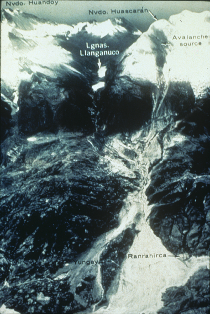
Although the earthquake itself caused much death and damage, severe losses were also caused by a huayco which swept down the steep slopes of the Cordillera Blanca from Nevados Huascarán into the Callejón del Huaylas, a steep valley paralleling the coast. Yungay and thousands of its residents were buried under tens of feet of mud, earth, water, boulders, and debris. Huarás, capital of the Ancash Department, was struck by a huayco 29 years ago and 6,000 lives were lost. On May 31, the earthquake and its side-effects damaged more than 70 percent of the buildings in the valley city, and took an estimated 20,000 lives.
The losses in Peru have not yet been completely described. Like a grim legend, which grows grimmer with each telling, the death toll leaps upward week by week. Five days after the earthquake, Peruvian officials feared a death toll as high as 30,000. Several days later that figure was tentatively raised to 50,000. An Associated Press dispatch on July 14 said Peru's Minister of Health now estimated the number of dead and missing persons to be 70,000. It may be impossible ever to assess fully the toll of this seismic disaster.
Property damage has been tentatively put at $530 million, but here again, the assessment is difficult. The destruction of towns like Yungay was virtually complete - how does one put a value on a community? In a country of 13 million persons, nearly a million are homeless. What is the cost of such a massive dislocation?
Huyco: An Incan world used to describe the avalanches which are a chronic threat to residents of steep Andean valleys.
Abridged from Earthquake Information Bulletin, September - October 1970, Volume 2, Number 5.
From the USGS event page for iscgem796163. U.S. Geological Survey text and figures are in the public domain.
What the record says
NCEI’s account, from the sources it cites.
On May 31, 1970, at 15:23 [local time] a catastrophic earthquake occurred in Peru. The epicenter was about 36 km from the coast of Peru.
50,000 killed; 50,000 missing; 50,000 injured; 500,000 left without food (Ref #417).66,794 killed or missing; 1 million homeless; $250 million damage (Ref #45).54,000 killed; $507 million damage (Ref #1039).$530 million damage (Ref #1250).Intensity IX (Ref #1111).Intensity X (Ref #1208).
The earthquake affected the coastal region, from Pisco to Chiclayo. Intensity VIII observed from Casma to Chimbote and in the Santa Rio River Valley from Aija to Caraz; 50-70% of Chimbote destroyed (pop. 80,000); 70% of Huaras destroyed (pop. 50,000 to 65,000).
The Santa Rio River valley experienced ice avalanches, rock slides, and sludge which flowed 16 km down the valley. In Yangay, nearly 19,000 people died; only 2,500 surived. The city was buried under more than 4 m of sludge.
The earthquake generated a weak tsunami which was observed along the Peruvian coast and on tide gauges in Japan.
Photos
From the NCEI/WDS Natural Hazards Image Database (doi:10.7289/V5154F01). Only photos by the USGS and NOAA, which are public domain, are shown.
Sources NCEI cites
The publications NCEI lists for this record. The numbers match the “reference #” notes in its account above.
- #12788 Cardona, O.D., Ordaz, M., Salgado-Galvez, M.A., Barbat, A.H. and Carreno, M.L. (2018). Latin American and Caribbean earthquakes in the GEMs Earthquake Consequences Database (GEMECD). Natural hazards, 93(1), 113-125. DOI:10.1007/s11069-017-3087-9
- #12952 Lomnitz, C. (1970). Preliminary note: The Peru Earthquake of May 31 1970. BSSA, vol 60, No. 4, pp 1413–1416.
- #1250 Centre for Research on the Epidemiology of Disasters (CRED) and the U.S. Office of Foreign Disaster Assistance (OFDA) (2001). EM-DAT: The OFDA/CRED International Disaster Database, Universite Catholique de Louvain, Brussels, Belgium, link
- #417 Soloviev, S L., Ch. N. Go, and Kh. S. Kim (1992). Catalog of tsunamis in the Pacific, 1969-1982. Academy of Sciences of the USSR, Moscow, 208 p. Translated from Russian by Amerind Publishing Co. Pvt. Ltd., New Delhi, India, 1988 [Originally published in Russian in 1986].
- #45 U.S. Department of the Interior, Geological Survey and U.S. Department of Commerce, National Oceanic and Atmospheric Administration (1928-1986). United States Earthquakes, Annual publication, published 1928-1986. vol.s for 1928-1965 issued by the U.S. Coast and Geodetic Survey; volumes for 1966-1969 issued by the National Earthquake Information Center; volume for 1970 issued by the National Geophysical Data Center; volumes for 1971-1972 issued by the National Geophysical And Solar-Terrestrial Data Center; volumes for 1973-1980 published jointly by the National Oceanic and Atmospheric Administration (NOAA) and the U.S. Geological Survey; volumes for 1981-1986 published by the U.S. Geological Survey. [on shelf]
- #1039 Rothe, J.P. (1966-1973). Annual Summary of Information on Natural Disasters, UNESCO, Paris, France, 1966 (no. 1) through 1973 (no. 8), 612 p.
- #1111 Silgado F., Enrique (1973). Historia de los sismos mas notables ocurridos en el Peru (1513-1970), Geofisica Panamericana, vol. 2, no. 1, January 1973, p. 179-243. [English translation.]
- #1208 Askew, B.L., and S.T. Algermissen (1985). Catalog of Earthquakes for South America, Hypocenter and Intensity Data, vol. 7A - Peru, Centro Regional de Sismologia para America del Sur, Lima, Peru.
- #1038 Bolt, B.A., W.L. Horn, G.A. MacDonald, and R.F. Scott (1977). Geological Hazards: Earthquakes, Tsunamis, Volcanoes, Avalanches, Landslides, Floods. Revised, 2nd Edition. Springer-Verlag Publishing Co., New York, p 305-312.
- #1314 Kanamori, Hiroo (1977). The energy release of great earthquakes. Journal of Geophysical Research, vol. 82, p. 2981-2987.
Other significant earthquakes nearby
Within 200 km, the deadliest first.
- January 7, 1725, Trujillo, Ancash, Lima, Peru
- November 10, 1946, Jocaibamba,cerro Angaschaj,cerro Sillapata, Peru
- February 14, 1619, Trujillo, Piura, Santa, Peru
- October 17, 1966, Lima,huacho,huaura, Chancay,supe,san Nicolas, Peru
- February 21, 1996, Chimbote, Callao, Northern, Peru
- April 18, 1962, Casma,huaraz,quiruvilca,trujillo, Peru
- October 2, 1987, Santaog DE Chuco, Trujillo, Chimbote, Peru
- June 7, 2020, Chimbote, Coast, Peru
- January 11, 1986, Huarmey, Casma, Huarax, Chimbote, Peru
- September 24, 1963, Huayllacayan,cajacay,malyas,malvas,huaraz, Peru
- August 21, 1985, Chimbote, Coast, Peru
- June 18, 1678, Lima,salinas-Huaura,lima,callao,chancay, Peru
- February 14, 1658, Trujillo, Peru
- September 3, 1967, Off Coast, Peru
More
Significant earthquakes of 1970The 1900sEvery quake the USGS located in 1970Recent earthquakes near hereThis day in weather history
Sources
Significant earthquakes from NOAA’s National Centers for Environmental Information, Global Historical Hazard Database, cited as NCEI/WDS, doi:10.7289/V5PN93H7. Public domain. Read 2026-10-01. NCEI earthquake 4531. The written accounts and the magnitude estimates are from the USGS earthquake catalog, event iscgem796163, matched to this record by time, place and magnitude.