M7.9 earthquake 34 km SW of Chimbote, Peru
A magnitude 7.9 earthquake struck 34 km SW of Chimbote, Peru on Sun, May 31, 1970, 3:23 PM GMT-5 (20:23 UTC), 58 km (36 mi) below the surface.
Map
Where this earthquake was located, with the others nearby. Select one for its page.
The earthquake
- Magnitude
- 7.9 (Mw, moment), major
- Magnitude from
- ISC-GEM global catalog
- Local time
- UTC
- 1970-05-31 20:23:30 UTC
- Depth
- 58.4 km (36.3 mi), shallow
- Epicenter
- 9.266° S, 78.847° W
- Region
- Peru
- Strongest shaking
- VIII, severe shaking
- Tsunami flag
- No
- Status
- Reviewed by a seismologist
Deaths and damage
From NOAA NCEI’s Significant Earthquake Database (record 4531), matched to this event by time and place.
- Deaths
- 66,794
- Injuries
- 50,000
- Damage
- $530 million
- Houses destroyed
- Many (101 to 1,000)
- Houses damaged
- Many (101 to 1,000)
Where the literature gives no number, NCEI records a description on a scale of 1 to 4, printed here in its words. Damage is in millions of US dollars of the year of the event, not adjusted for inflation.
From Wikipedia
The 1970 Ancash earthquake (also known as the Great Peruvian earthquake) occurred on 31 May off the coast of Peru in the Pacific Ocean at 15:23:29 local time. Combined with a resultant landslide, it is the most catastrophic natural disaster in the history of Peru. Due to the large amounts of snow and ice included in the landslide that caused an estimated 66,794–70,000 fatalities, it is also considered to be the world's deadliest avalanche.
Text from Wikipedia, “1970 Ancash earthquake”, licensed CC BY-SA 4.0. Quoted as written; the full article has the rest.
The article is about the earthquake NOAA’s record describes, matched to this one by date, place and magnitude.
Wikidata records: 50,000 injured. These are counts entered by Wikidata’s editors; they may differ from the official count, and this page never adds them to another figure. Q3245204, CC0.
What happened
The USGS’s account of the effects of this earthquake.
On Sunday, May 31, at 27.3 seconds after 4:23 pm EDT, a magnitude 7.9 earthquake centered at 9.2° South, 78.8° West, about 22 miles west of Chimbite, a major Peruvian fishing port.
Damage reached from Chiclayo in the north to Lima in the south, but coastal towns near the epicenter and towns in the Santa River Valley to the east suffered most.
Casma, a coastal city south of the earthquake epicenter with about 13,000 population sustained severe damage to 90 percent of its structures, but had comparatively few deaths. Chimbote, north of Casma, reported almost 3,000 deaths, and sustained much damage to 70 to 80 percent of its structures. According to preliminary reports, most of the fatalities resulting from the earthquake were caused by building collapses. Townsites were too often located on alluvial fill, and dwellings were mostly of adobe.
Although the earthquake itself caused much death and damage, severe losses were also caused by a huayco which swept down the steep slopes of the Cordillera Blanca from Nevados Huascarán into the Callejón del Huaylas, a steep valley paralleling the coast. Yungay and thousands of its residents were buried under tens of feet of mud, earth, water, boulders, and debris. Huarás, capital of the Ancash Department, was struck by a huayco 29 years ago and 6,000 lives were lost. On May 31, the earthquake and its side-effects damaged more than 70 percent of the buildings in the valley city, and took an estimated 20,000 lives.
The losses in Peru have not yet been completely described. Like a grim legend, which grows grimmer with each telling, the death toll leaps upward week by week. Five days after the earthquake, Peruvian officials feared a death toll as high as 30,000. Several days later that figure was tentatively raised to 50,000. An Associated Press dispatch on July 14 said Peru's Minister of Health now estimated the number of dead and missing persons to be 70,000. It may be impossible ever to assess fully the toll of this seismic disaster.
Property damage has been tentatively put at $530 million, but here again, the assessment is difficult. The destruction of towns like Yungay was virtually complete - how does one put a value on a community? In a country of 13 million persons, nearly a million are homeless. What is the cost of such a massive dislocation?
Huyco: An Incan world used to describe the avalanches which are a chronic threat to residents of steep Andean valleys.
Abridged from Earthquake Information Bulletin, September - October 1970, Volume 2, Number 5.
From the USGS event page for iscgem796163. U.S. Geological Survey text and figures are in the public domain.
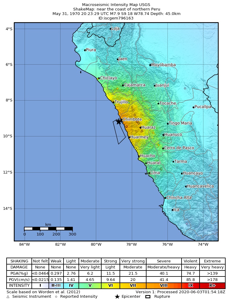
Shaking
The USGS ShakeMap: shaking estimated from seismic stations and the quake’s size, on the Modified Mercalli intensity scale.
- Strongest estimated
- VIII, severe shaking
- Peak ground acceleration
- 40.7% of gravity
- Peak ground velocity
- 4.0 cm/s
- Map
- Automatic
Did you feel it?
No one has reported feeling this quake to the USGS.
Fault motion and ground failure
How the rock slipped, from the moment tensor, and the USGS estimate of landslides and liquefaction.
- Landslide alert
- Red
- Liquefaction alert
- Yellow
How well it is located
Reviewed by a seismologist.
- Magnitude uncertainty
- ±0.30
- Depth from
- From location
Nearest places
Distance and direction from each place to the epicenter, with its forecast.
Nearby
Within 100 km, magnitude 4.9 and up: 8 in the 60 days after this one and 0 in the 30 days before it.
After
- 6.124 km WNW of Huarmey, Peru · 20579 days ago · 51 km deep · 96 km away
- 6.259 km SW of Puerto Santa, Peru · 20578 days ago · 45 km deep · 27 km away
- 5.760 km SW of Puerto Casma, Peru · 20577 days ago · 56 km deep · 60 km away
- 6.451 km WNW of Huarmey, Peru · 20575 days ago · 55 km deep · 77 km away
- 5.560 km SW of Puerto Casma, Peru · 20565 days ago · 56 km deep · 58 km away
- 5.562 km W of Huarmey, Peru · 20558 days ago · 58 km deep · 79 km away
- 5.753 km W of Huarmey, Peru · 20552 days ago · 65 km deep · 84 km away
- 5.659 km WSW of Puerto Santa, Peru · 20549 days ago · 55 km deep · 34 km away
Earthquakes todayPeru earthquakesLive radar here
Sources
From the USGS Earthquake Hazards Program and its partner networks, event iscgem796163 (also filed as atlas19700531202327). Read Sat, Oct 3, 2026, 12:39 PM UTC.