February 22, 2002 Earthquake: Mexicali, Baja California, Mexico
A magnitude 5.5 earthquake struck Mexicali, Baja California, Mexico on February 22, 2002 at 19:32:41 UTC, 7 km below the surface.
Map
Where it struck, with the other significant earthquakes within 200 km. Circles are sized and colored by magnitude; select one for its page.
The earthquake
- Date
- February 22, 2002
- Time
- 19:32:41 UTC
- Place
- Mexicali, Baja California, Mexico
- Magnitude
- 5.5 (Mw)
- Magnitude scales
- Mw 5.5 · Ms 5.5 · mb 5.4
- Focal depth
- 7 km (4 mi)
- Tsunami
- None recorded
- Epicenter
- 32.319° N, 115.322° W
- Country
- Mexico
- Region
- North America and Hawaii
- USGS record
- The USGS’s page for this earthquake
Mw: moment magnitude, based on the slip on the fault and the area that slipped. Ms: surface-wave magnitude. mb: body-wave (P-wave) magnitude. NCEI’s headline magnitude is the best of these for the earthquake.
The toll
- Damage
- Limited (under about $1 million)
Where the literature gives no number, NCEI records a description on a scale of 1 to 4, printed here in its words. Damage is in millions of US dollars of the year of the event, not adjusted for inflation.
What happened
The USGS’s account of the effects of this earthquake.
Some damage at Mexicali, Baja California. Felt at San Luis Rio Colorado, Sonora. Felt (V) at Imperial; (IV) at Brawley, Calexico, El Centro and Holtville; (III) at Aliso Viejo, Carlsbad, Chula Vista, Costa Mesa, Del Mar, El Cajon, El Centro, Escondido, Irvine, Laguna Hills, Laguna Niguel, La Jolla, Lakeside, La Mesa, Mission Viejo, National City, Newport Beach, San Clemente, San Diego, Solana Beach, Spring Valley and Temecula, California. Also felt (III) at Yuma, Arizona. Felt from Los Angeles, California to Phoenix, Arizona.
From the USGS event page for ci12456384. U.S. Geological Survey text and figures are in the public domain.
Tectonic setting
Why earthquakes happen here, from the USGS tectonic summary.
A moderate earthquake of M5.7 occurred near the southern end of the Laguna Salada fault at 11:32 a.m. (local time) on the morning of Friday, February 22, 2002 (see Figure). The earthquake was felt over much of the U.S. border region from the Imperial Valley to San Diego and as far north as Orange County. It was followed by a very robust aftershock sequence including 13 events of magnitude 3 or greater as of 7:00 p.m. The largest aftershock so far was a M3.9 event at 12:33 p.m. This type of robust aftershock sequence is typical of the area and more M~3 and even M~4 events should be expected in the next few days.
The Laguna Salada fault was the probable source of a M~7 earthquake 110 years ago on February 23, 1890. The last significant (M≥5) earthquake in this region was a M5.4 earthquake on February 7, 1987. This fault is an extension to the south of the Elsinore fault of California and has a slip rate on the order of 4 mm/yr. This earthquake has a focal mechanism suggest strike-slip motion on a fault with an orientation similar to the Laguna Salada.
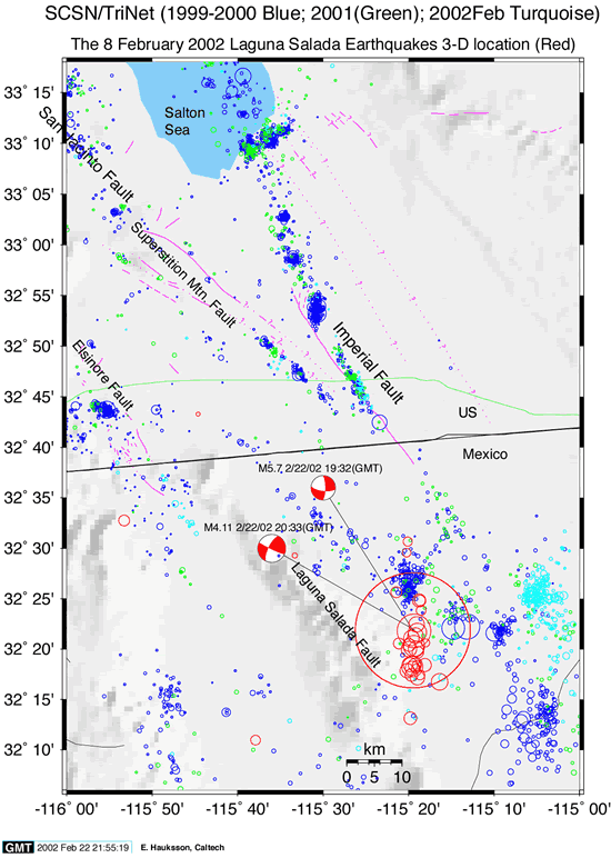
From the USGS event page for ci12456384. U.S. Geological Survey text and figures are in the public domain.
Magnitude estimates
The magnitudes the USGS catalog lists for this earthquake, by scale and by who computed them. NCEI’s own scales are in the table above.
| Mag. | Scale | Computed by | Notes |
|---|---|---|---|
| 5.7 | Mw, moment | Southern California Seismic Network | Preferred · Final · 0 stations |
| 5.7 | Mwb, body-wave moment | USGS National Earthquake Information Center | Reviewed |
| 5.48 | Mw, moment | ISC-GEM global catalog | Final · ±0.1 |
| 5.5 | Mwc, centroid moment | Global CMT project | Preliminary |
What the record says
NCEI’s account, from the sources it cites.
Some damage at Mexicali, Baja California. Felt at San Luis Rio Colorado, Sonora. Felt (V) at Imperial; (IV) at
Brawley, Calexico, El Centro and Holtville; (III) at
Aliso Viejo, Carlsbad, Chula Vista, Costa Mesa, Del
Mar, El Cajon, El Centro, Escondido, Irvine, Laguna
Hills, Laguna Niguel, La Jolla, Lakeside, La Mesa,
Mission Viejo, National City, Newport Beach, San
Clemente, San Diego, Solana Beach, Spring Valley and
Temecula, California. Also felt (III) at Yuma,
Arizona. Felt from Los Angeles, California to Phoenix,
Arizona. (reference #1053)
Sources NCEI cites
The publications NCEI lists for this record. The numbers match the “reference #” notes in its account above.
- #1053 National Earthquake Information Center (NEIC) (1971 to 2013). Preliminary Determination of Epicenters (PDE), a weekly and monthly publication, National Earthquake Information Center, U.S. Geological Survey, Golden, Colorado, 1971 to 2013.
Other significant earthquakes nearby
Within 200 km, the deadliest first.
- May 19, 1940, California, Mexico, United States
- June 23, 1915, El Centro, California, United States
- April 4, 2010, Baja California, Mexico
- November 24, 1987, Superstition Hills, California, United States
- January 1, 1927, California, Mexico, United States
- June 9, 1980, Northwestern Mexico
- February 9, 2008, Baja California, Mexico
- December 30, 2009, Mexicali, Mexico
- November 29, 1852, N. Mexico
- October 15, 1979, Mexicali, Imperial Valley, Mexico, California, United States
- February 24, 1892, San Diego, California, Baja California, USA, Mexico
- December 31, 1934, Baja,imperial Valley, California, United States
- June 15, 2010, Ocotillo, California, United States
- April 26, 1981, Westmorland,calipatria, California, United States
- May 27, 1862, San Diego, California, United States
More
Significant earthquakes of 2002The 2000sEvery quake the USGS located in 2002Recent earthquakes near hereThis day in weather history
Sources
Significant earthquakes from NOAA’s National Centers for Environmental Information, Global Historical Hazard Database, cited as NCEI/WDS, doi:10.7289/V5PN93H7. Public domain. Read 2026-10-01. NCEI earthquake 5623. The written accounts and the magnitude estimates are from the USGS earthquake catalog, event ci12456384, matched to this record by time, place and magnitude.