M5.7 earthquake 13km WSW of Delta, B.C., MX
A magnitude 5.7 earthquake struck 13km WSW of Delta, B.C., MX on Fri, Feb 22, 2002, 11:32 AM PST (19:32 UTC), 7 km (4 mi) below the surface.
Map
Where this earthquake was located, with the others nearby. Select one for its page.
The earthquake
- Magnitude
- 5.7 (Mw, moment), moderate
- Magnitude from
- Southern California Seismic Network
- Local time
- UTC
- 2002-02-22 19:32:41 UTC
- Depth
- 7.0 km (4.4 mi), shallow
- Epicenter
- 32.319° N, 115.322° W
- Region
- Mexico
- Felt reports
- 3,281
- Strongest shaking
- VII, very strong shaking
- PAGER alert
- Yellow
- Tsunami flag
- No
- Status
- Reviewed by a seismologist
Magnitude estimates
Different scales measure different things and differ by a few tenths. The USGS marks one as preferred, and it is the one this page uses.
| Mag. | Scale | Computed by | Notes |
|---|---|---|---|
| 5.7 | Mw, moment | Southern California Seismic Network | Preferred · Final · 0 stations |
| 5.7 | Mwb, body-wave moment | USGS National Earthquake Information Center | Reviewed |
| 5.48 | Mw, moment | ISC-GEM global catalog | Final · ±0.1 |
| 5.5 | Mwc, centroid moment | Global CMT project | Preliminary |
Deaths and damage
From NOAA NCEI’s Significant Earthquake Database (record 5623), matched to this event by time and place.
- Damage
- Limited (under about $1 million)
Where the literature gives no number, NCEI records a description on a scale of 1 to 4, printed here in its words. Damage is in millions of US dollars of the year of the event, not adjusted for inflation.
What happened
The USGS’s account of the effects of this earthquake.
Some damage at Mexicali, Baja California. Felt at San Luis Rio Colorado, Sonora. Felt (V) at Imperial; (IV) at Brawley, Calexico, El Centro and Holtville; (III) at Aliso Viejo, Carlsbad, Chula Vista, Costa Mesa, Del Mar, El Cajon, El Centro, Escondido, Irvine, Laguna Hills, Laguna Niguel, La Jolla, Lakeside, La Mesa, Mission Viejo, National City, Newport Beach, San Clemente, San Diego, Solana Beach, Spring Valley and Temecula, California. Also felt (III) at Yuma, Arizona. Felt from Los Angeles, California to Phoenix, Arizona.
From the USGS event page for ci12456384. U.S. Geological Survey text and figures are in the public domain.
Shaking
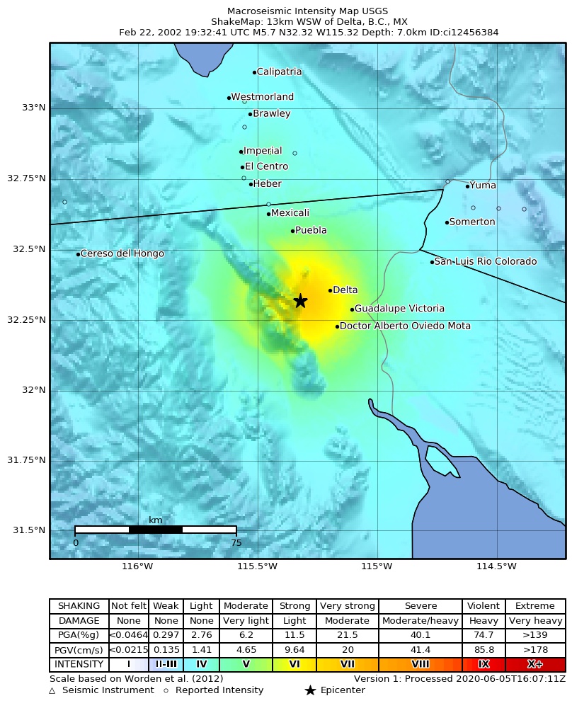
The USGS ShakeMap: shaking estimated from seismic stations and the quake’s size, on the Modified Mercalli intensity scale.
- Strongest estimated
- VII, very strong shaking
- Peak ground acceleration
- 34.3% of gravity
- Peak ground velocity
- 3.4 cm/s
- Map
- Automatic
Did you feel it?
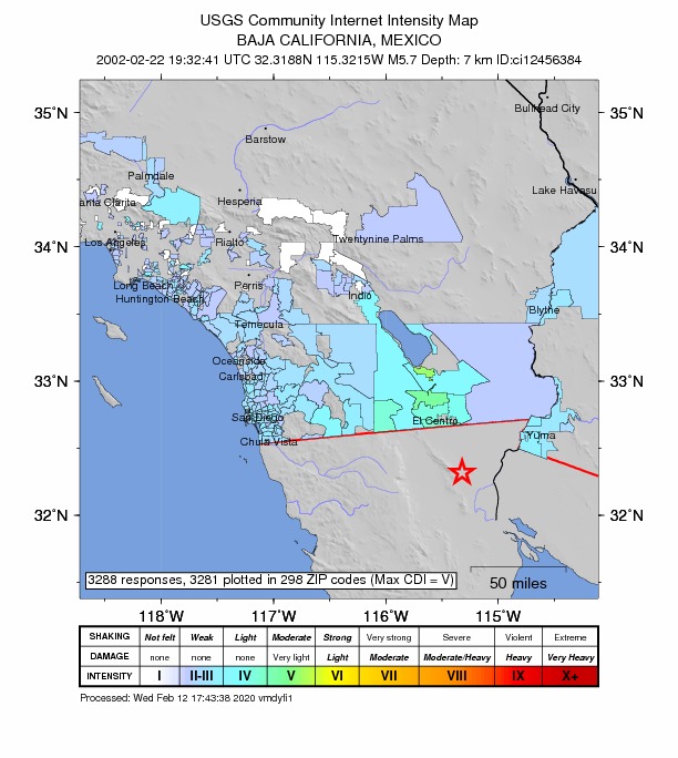
3,281 people reported to the USGS what they felt; the strongest reported shaking was V, moderate shaking.
Estimated impact
The USGS PAGER system estimates deaths and economic losses from the shaking and the population and buildings exposed to it.
- Alert level
- Yellow: some damage and deaths possible, a local or regional response
Fault motion and ground failure
How the rock slipped, from the moment tensor, and the USGS estimate of landslides and liquefaction.
- Faulting
- Strike-slip
- Nodal plane 1
- Strike 190°, dip 66°, rake -4°
- Nodal plane 2
- Strike 282°, dip 87°, rake -156°
Tectonic setting
Why earthquakes happen here, from the USGS tectonic summary.
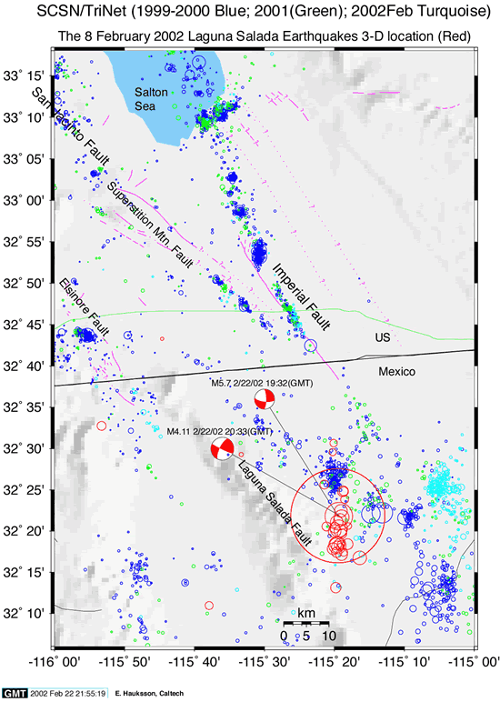
A moderate earthquake of M5.7 occurred near the southern end of the Laguna Salada fault at 11:32 a.m. (local time) on the morning of Friday, February 22, 2002 (see Figure). The earthquake was felt over much of the U.S. border region from the Imperial Valley to San Diego and as far north as Orange County. It was followed by a very robust aftershock sequence including 13 events of magnitude 3 or greater as of 7:00 p.m. The largest aftershock so far was a M3.9 event at 12:33 p.m. This type of robust aftershock sequence is typical of the area and more M~3 and even M~4 events should be expected in the next few days.
The Laguna Salada fault was the probable source of a M~7 earthquake 110 years ago on February 23, 1890. The last significant (M≥5) earthquake in this region was a M5.4 earthquake on February 7, 1987. This fault is an extension to the south of the Elsinore fault of California and has a slip rate on the order of 4 mm/yr. This earthquake has a focal mechanism suggest strike-slip motion on a fault with an orientation similar to the Laguna Salada.
From the USGS event page for ci12456384. U.S. Geological Survey text and figures are in the public domain.
How well it is located
Reviewed by a seismologist.
- Location uncertainty
- About 2.4 km horizontally, 31.9 km in depth
- Depth from
- From location
- Station coverage gap
- 218°, poorly surrounded by stations
- Stations used
- 20
Nearest places
Distance and direction from each place to the epicenter, with its forecast.
Nearby
Within 100 km, magnitude 2.7 and up: 119 in the 60 days after this one and 4 in the 30 days before it.
After
- 3.412km WSW of Delta, B.C., MX · 8989 days ago · 7 km deep · 1 km away
- 3.212km W of Delta, B.C., MX · 8989 days ago · 7 km deep · 6 km away
- 3.113km WSW of Delta, B.C., MX · 8989 days ago · 7 km deep · 2 km away
- 3.013km WSW of Delta, B.C., MX · 8989 days ago · 7 km deep · 3 km away
- 3.211km WSW of Delta, B.C., MX · 8989 days ago · 7 km deep · 2 km away
- 2.915km WNW of Alberto Oviedo Mota, B.C., MX · 8989 days ago · 7 km deep · 6 km away
- 3.114km WSW of Delta, B.C., MX · 8989 days ago · 7 km deep · 3 km away
- 3.012km WSW of Delta, B.C., MX · 8989 days ago · 7 km deep · 1 km away
- 3.213km WSW of Delta, B.C., MX · 8989 days ago · 7 km deep · 0 km away
- 3.513km WSW of Delta, B.C., MX · 8989 days ago · 7 km deep · 1 km away
- 4.114km WSW of Delta, B.C., MX · 8989 days ago · 7 km deep · 2 km away
- 3.012km WSW of Delta, B.C., MX · 8989 days ago · 7 km deep · 1 km away
- 2.711km WSW of Delta, B.C., MX · 8989 days ago · 7 km deep · 3 km away
- 2.813km WSW of Delta, B.C., MX · 8989 days ago · 7 km deep · 1 km away
- 2.814km W of Delta, B.C., MX · 8989 days ago · 7 km deep · 6 km away
- 3.014km WSW of Delta, B.C., MX · 8989 days ago · 7 km deep · 2 km away
- 3.213km WSW of Delta, B.C., MX · 8989 days ago · 7 km deep · 1 km away
- 2.815km SW of Delta, B.C., MX · 8989 days ago · 7 km deep · 4 km away
- 3.015km WNW of Alberto Oviedo Mota, B.C., MX · 8989 days ago · 7 km deep · 6 km away
- 3.615km WSW of Delta, B.C., MX · 8989 days ago · 7 km deep · 3 km away
- 3.214km WNW of Alberto Oviedo Mota, B.C., MX · 8989 days ago · 7 km deep · 5 km away
- 2.915km SW of Delta, B.C., MX · 8988 days ago · 7 km deep · 5 km away
- 2.915km WNW of Alberto Oviedo Mota, B.C., MX · 8988 days ago · 7 km deep · 7 km away
- 2.813km WSW of Delta, B.C., MX · 8988 days ago · 7 km deep · 1 km away
- 2.914km SW of Delta, B.C., MX · 8988 days ago · 7 km deep · 4 km away
- 2.816km WNW of Alberto Oviedo Mota, B.C., MX · 8988 days ago · 7 km deep · 7 km away
- 3.415km SW of Delta, B.C., MX · 8988 days ago · 7 km deep · 4 km away
- 3.715km WSW of Delta, B.C., MX · 8988 days ago · 7 km deep · 4 km away
- 2.914km WSW of Delta, B.C., MX · 8988 days ago · 7 km deep · 1 km away
- 2.714km W of Delta, B.C., MX · 8988 days ago · 7 km deep · 6 km away
- 2.914km WSW of Delta, B.C., MX · 8988 days ago · 7 km deep · 1 km away
- 2.814km WSW of Delta, B.C., MX · 8988 days ago · 7 km deep · 3 km away
- 3.014km WSW of Delta, B.C., MX · 8988 days ago · 7 km deep · 1 km away
- 2.915km W of Alberto Oviedo Mota, B.C., MX · 8988 days ago · 7 km deep · 10 km away
- 2.814km W of Alberto Oviedo Mota, B.C., MX · 8988 days ago · 7 km deep · 9 km away
- 2.812km W of Delta, B.C., MX · 8988 days ago · 7 km deep · 2 km away
- 3.013km WSW of Delta, B.C., MX · 8988 days ago · 7 km deep · 1 km away
- 3.415km WNW of Alberto Oviedo Mota, B.C., MX · 8988 days ago · 7 km deep · 5 km away
- 3.115km WNW of Alberto Oviedo Mota, B.C., MX · 8988 days ago · 7 km deep · 7 km away
- 2.916km W of Alberto Oviedo Mota, B.C., MX · 8988 days ago · 7 km deep · 12 km away
- 2.711km WSW of Delta, B.C., MX · 8988 days ago · 7 km deep · 2 km away
- 2.914km W of Delta, B.C., MX · 8988 days ago · 7 km deep · 3 km away
- 2.814km SW of Delta, B.C., MX · 8988 days ago · 7 km deep · 4 km away
- 2.913km WSW of Delta, B.C., MX · 8988 days ago · 7 km deep · 3 km away
- 2.915km WNW of Alberto Oviedo Mota, B.C., MX · 8987 days ago · 7 km deep · 6 km away
- 3.012km W of Delta, B.C., MX · 8987 days ago · 6 km deep · 5 km away
- 2.816km W of Alberto Oviedo Mota, B.C., MX · 8987 days ago · 7 km deep · 10 km away
- 3.216km WSW of Delta, B.C., MX · 8987 days ago · 7 km deep · 5 km away
- 2.717km W of Alberto Oviedo Mota, B.C., MX · 8987 days ago · 7 km deep · 10 km away
- 2.915km WSW of Delta, B.C., MX · 8987 days ago · 7 km deep · 3 km away
- 3.310km W of Calipatria, CA · 8986 days ago · 7 km deep · 96 km away
- 4.011km WSW of Delta, B.C., MX · 8986 days ago · 6 km deep · 2 km away
- 3.014km WSW of Delta, B.C., MX · 8986 days ago · 7 km deep · 2 km away
- 3.315km WSW of Delta, B.C., MX · 8986 days ago · 7 km deep · 3 km away
- 3.214km WSW of Delta, B.C., MX · 8986 days ago · 7 km deep · 2 km away
- 3.314km WSW of Delta, B.C., MX · 8986 days ago · 7 km deep · 2 km away
- 2.813km NNW of Delta, B.C., MX · 8986 days ago · 7 km deep · 16 km away
- 3.014km SE of Puebla, B.C., MX · 8986 days ago · 7 km deep · 17 km away
- 3.013km NNW of Delta, B.C., MX · 8986 days ago · 7 km deep · 16 km away
- 2.814km SE of Puebla, B.C., MX · 8986 days ago · 7 km deep · 17 km away
The first 60 of 119.
Before
Earthquakes todayMexico earthquakesLive radar here
Sources
From the USGS Earthquake Hazards Program and its partner networks, event ci12456384 (also filed as gcmtb022202c, usp000ayyw, gcmt20020222193241, iscgem2904446, atlas20020222193241). Read Sat, Oct 3, 2026, 10:56 AM UTC.