June 16, 1964 Earthquake: W Coast, Honshu, Japan
A magnitude 7.6 earthquake struck W Coast, Honshu, Japan on June 16, 1964 at 04:01:41 UTC, 57 km below the surface. It killed 36 people.
Map
Where it struck, with the other significant earthquakes within 200 km. Circles are sized and colored by magnitude; select one for its page.
The earthquake
- Date
- June 16, 1964
- Time
- 04:01:41 UTC
- Place
- W Coast, Honshu, Japan
- Magnitude
- 7.6 (Mw)
- Focal depth
- 57 km (35 mi)
- Intensity
- 8 on the Modified Mercalli scale
- Tsunami
- Yes: the tsunami it caused
- Epicenter
- 38.384° N, 139.232° E
- Country
- Japan
The toll
- Deaths
- 36
- Injuries
- 385
- Damage
- $800 million
- Houses destroyed
- 3,557
- Houses damaged
- 12,237
Where the literature gives no number, NCEI records a description on a scale of 1 to 4, printed here in its words. Damage is in millions of US dollars of the year of the event, not adjusted for inflation.
What the record says
NCEI’s account, from the sources it cites.
Ref #414:
1964, June 16, 13:02 local time. There was a very strong earthquake and a moderate tsunami with source on the shelf of the Sea of Japan in the form of an ellipse measuring 90 x 35 km, extending along Honshu Island. The length of the zone of perceptibility was 1000 km.
The total losses from the earthquake and tsunami (separate figures for each phenomenon are not available) have been estimated at 80 million dollars; 26 people died and about 450 were injured; about 86,400 people suffered material losses.
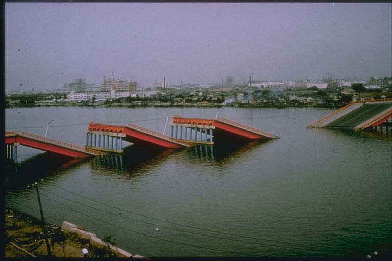
The bulk of the damage occurred at Niigata. The seismic tremors themselves did slight damage to the city, except that a fire lasting two weeks broke out in the region of the oil tanks.
However, as the result of the seismic shocks there was an almost instantaneous compaction, with fractures, of the loose delta deposits of the Shinano and Agano Rivers, on which a large part of the city is located. An abrupt increase in the pressure of ground waters at a depth of about 1 m, caused the appearance of numerous mud volcanoes, which ejected a mixture of sand and water. This, together with other circumstances, led to the flooding of the soil. The upper loose layer liquesced.
The cause of the earthquake was the upward dislocation along tectonic fractures of a system of interlocked Neogene - Quaternary anticlinals, including the small rocky Ava Island, and the simultaneous settling of the narrow underwater depression, separating the above mentioned system from Honshu Island. Thus the dislocations in the earthquake corresponded to the general direction of the most recent tectonic movements in its focal zone. Quantitatively, these dislocations characterized by the following figures. Ava Island rose 1-1.5 m and tilted 1 deg to the northwest. The maximum elevation occurred on the floor of the sea 15 km south of Ava Island and was 5-6 m. The maximal local subsidence, near Honshu Island, was estimated at 3-4 m. In area, the zone of subsidences was approximately one tenth the area of elevations.
The coast of Honshu Island adjoining the zone of subsidences subsided 10-20 cm. According to the tide gauge data, the slow tectonic movements in the focal zone in the four years before the earthquake were directed oppositely to the dislocations, but before and after this period, they had the same direction. On the basis of geomorphological observations, Japanese specialists surmise that about 800 years was required to prepare for the earthquake [this may be exaggerated]. The tsunami was maximal on the coast of Honshu Island closes to its source.
Ref #45:
June 16, 1964, 04:01:44.3 UTC, 38.3 N, 139.1 E, magnitude 7.25-7.5, depth 57 km. 26 killed, 447 injured
Ref #10476 (v. 12.1): 1964-06-16 04:01:41.86 UTC, 38.384 N, 139.232 E, magnitude 7.6 Mw
Ref #1040:
Although the number of victims was fortunately small (36 dead or missing, 385 injured), the material damage was great: 3,534 houses destroyed, 11,000 houses damaged. […]The earthquake, of magnitude 7.4, occurred at a depth of 57 km below the Sea of Japan near the island of Awa-shima, in the deepest of the old formations in the tectonic zone called “internal arc of Honshu”. A tsunami generated by the earthquake ravaged the west coast of Honshu […] Investigation of damage in the town of Niigata show the adverse influence of a poor subsoil. Generally speaking, damage was due far more to perturbation of the subsoil than to direct effect of ground vibration on the buildings […] Oceanographic observations revealed the formation of a new fault in the sea bottom between Awa-shima and the coast of Honshu
Ref #1250: 800 million USD in damages.
Ref #14336: 29 deaths, 510 injured, 3557 houses destroyed, 12237 houses damaged, 290,475, 562,000 yen (~806.88 million U.S. dollars) in damages
Photos
From the NCEI/WDS Natural Hazards Image Database (doi:10.7289/V5154F01). Only photos by the USGS and NOAA, which are public domain, are shown.

Other significant earthquakes nearby
Within 200 km, the deadliest first.
- May 8, 1847, Zenkoji, Nagano, Japan
- September 27, 1611, Aidu, Japan
- May 20, 1751, NW, Honshu, Japan
- August 2, 887, Niigata, Honshu, Japan
- February 1, 1666, Takata, Japan
- December 18, 1828, Sandyo IN Etigo, Japan
- January 1, 2024, Ishikawa, Honshu, Japan
- July 10, 1804, Kisakata, Japan
- June 19, 1694, Ugo, Japan
- October 18, 1644, NW. Honshu Island, Japan
- March 15, 1914, Senhoku, Japan
- December 7, 1833, NW, Honshu, Japan
- October 23, 2004, Niigata Prefecture, Honshu, Japan
- September 25, 1810, Oga, Japan
- April 21, 1659, Aidu, Japan
More
Significant earthquakes of 1964The 1900sEvery quake the USGS located in 1964Recent earthquakes near hereThis day in weather history
Sources
Significant earthquakes from NOAA’s National Centers for Environmental Information, Global Historical Hazard Database, cited as NCEI/WDS, doi:10.7289/V5PN93H7. Public domain. Read 2026-09-24. NCEI earthquake 4322.