May 22, 1960 Earthquake: Puerto Montt, Valdivia, Chile
A magnitude 9.5 earthquake struck Puerto Montt, Valdivia, Chile on May 22, 1960 at 19:11:17 UTC, 33 km below the surface. It killed 2,226 people, counting the tsunami it caused.
Map
Where it struck, with the other significant earthquakes within 200 km. Circles are sized and colored by magnitude; select one for its page.
The earthquake
- Date
- May 22, 1960
- Time
- 19:11:17 UTC
- Place
- Puerto Montt, Valdivia, Chile
- Magnitude
- 9.5 (Mw)
- Magnitude scales
- Mw 9.5 · Ms 8.5
- Focal depth
- 33 km (21 mi)
- Intensity
- XII, extreme shaking, on the Modified Mercalli scale
- Tsunami
- Yes: the tsunami it caused
- Volcano
- The eruption it came with
- Epicenter
- 38.143° S, 73.407° W
- Country
- Chile
- Region
- South America
- USGS record
- The USGS’s page for this earthquake
Mw: moment magnitude, based on the slip on the fault and the area that slipped. Ms: surface-wave magnitude. NCEI’s headline magnitude is the best of these for the earthquake.
The toll
- Deaths
- 2,000; 2,226 with its tsunami and other effects
- Injuries
- 3,000
- Damage
- $1 billion
- Houses destroyed
- 58,622
Where the literature gives no number, NCEI records a description on a scale of 1 to 4, printed here in its words. Damage is in millions of US dollars of the year of the event, not adjusted for inflation.
From Wikipedia
On 22 May 1960, an earthquake and tsunami occurred in Chile, devastating the city of Valdivia. Most studies have placed it at 9.4–9.6 on the moment magnitude scale, making it the strongest earthquake ever recorded, while some studies have placed the magnitude lower than 9.4. It occurred in the afternoon (19:11:14 UTC, 15:11:14 local time), and lasted 10 minutes. The resulting tsunamis affected southern Chile, Hawaii, Japan, the Philippines, eastern New Zealand, southeast Australia, and the Aleutian Islands.
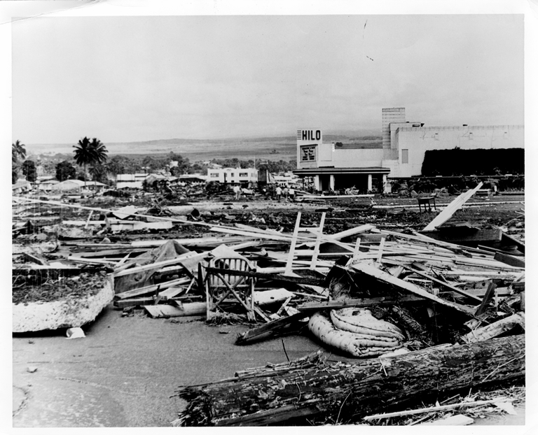
The epicenter of this megathrust earthquake was near Lumaco, approximately 570 kilometres (350 mi) south of Santiago, with Valdivia being the most affected city. The tremor caused localized tsunamis that severely battered the Chilean coast, with waves up to 25 metres (82 ft). The main tsunami traveled across the Pacific Ocean and devastated Hilo, Hawaii, where waves as high as 10.7 metres (35 ft) were recorded over 10,000 kilometres (6,200 mi) from the epicenter.
The death toll and monetary losses arising from this widespread disaster are not certain.
Text from Wikipedia, “1960 Valdivia earthquake”, licensed CC BY-SA 4.0. Quoted as written, shortened to its opening; the full article has the rest.
What happened
The USGS’s account of the effects of this earthquake.
Approximately 1,655 killed, 3,000 injured, 2,000,000 homeless, and $550 million damage in southern Chile; tsunami caused 61 deaths, $75 million damage in Hawaii; 138 deaths and $50 million damage in Japan; 32 dead and missing in the Philippines; and $500,000 damage to the west coast of the United States.
Abridged from United States Earthquakes, 1960.
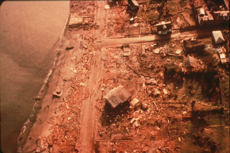
Severe damage from shaking occurred in the Valdivia-Puerto Montt area. Most of the casualties and much of the damage was because of large tsunamis which caused damage along the coast of Chile from Lebu to Puerto Aisen and in many areas of the Pacific Ocean. Puerto Saavedra was completely destroyed by waves which reached heights of 11.5 m (38 ft) and carried remains of houses inland as much as 3 km (2 mi). Wave heights of 8 m (26 ft) caused much damage at Corral.
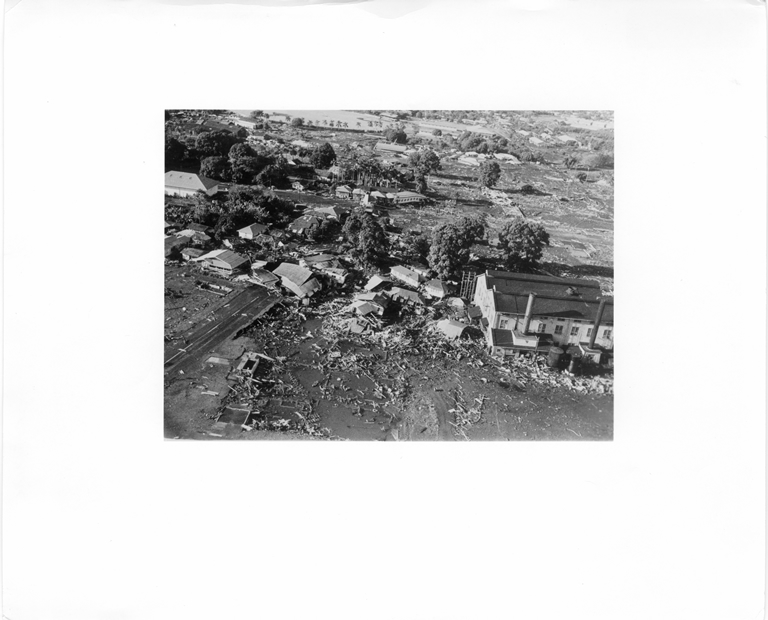
Tsunamis caused 61 deaths and severe damage in Hawaii, mostly at Hilo, where the runup height reached 10.6 m (35 ft). Waves as high as 5.5 m (18 ft) struck northern Honshu about 1 day after the quake, where it destroyed more than 1600 homes and left 185 people dead or missing. Another 32 people were dead or missing in the Philippines after the tsunami hit those islands. Damage also occurred on Easter Island, in the Samoa Islands and in California. One to 1.5 m (3-5 ft) of subsidence occurred along the Chilean coast from the south end of the Arauco Peninsula to Quellon on Chiloe Island. As much of 3 m (10 ft) of uplift occurred on Isla Guafo. Many landslides occurred in the Chilean Lake District from Lago Villarica to Lago Todos los Santos.
On May 24, Volcan Puyehue erupted, sending ash and steam as high as 6,000 m. The eruption continued for several weeks.
This quake was preceded by 4 foreshocks bigger than magnitude 7.0, including a magnitude 7.9 on May 21 that caused severe damage in the Concepcion area. Many aftershocks occurred, with 5 of magnitude 7.0 or greater through Nov 1.
This is the largest earthquake of the 20th Century. The rupture zone is estimated to be about 1000 km long, from Lebu to Puerto Aisen.
Note that the tsunami deaths from outside Chile are included in the 1,655 total. This is still considerably fewer than some estimates which were as high as 5,700. However, Rothe and others state that the initial reports were greatly overestimated. The death toll for this huge earthquake was less than it might have been because it it occurred in the middle of the afternoon, many of the structures had been built to be earthquake-resistant and the series of strong foreshocks had made the population wary.
From the USGS event page for official19600522191120_30. U.S. Geological Survey text and figures are in the public domain.
Magnitude estimates
The magnitudes the USGS catalog lists for this earthquake, by scale and by who computed them. NCEI’s own scales are in the table above.
| Mag. | Scale | Computed by | Notes |
|---|---|---|---|
| 9.5 | Mw, moment | USGS, official solution | Preferred · Preliminary |
| 9.55 | Mw, moment | ISC-GEM global catalog | Final · ±0.25 |
References for the magnitude and location
The USGS’s notes on how this earthquake’s official magnitude and location were set.
Official Magnitude updated 07-Nov-2016
Reference:
Kanamori, H., & Anderson, D. L. (1975).
Theoretical basis of some empirical relations in seismology.
Bulletin of the Seismological Society of America, 65(5), 1073-1095.
What the record says
NCEI’s account, from the sources it cites.
Ref #1040, #10973, #45, #4153, and #3973:
On May 22, 1960, a Mw 9.5 earthquake, the largest earthquake ever instrumentally recorded, occurred in southern Chile. The series of earthquakes that followed ravaged southern Chile and ruptured over a period of days a 1,000 km section of the fault, one of the longest ruptures ever reported. The number of fatalities associated with both the earthquake and tsunami has been estimated to be between 490 and 5,700. Reportedly there were 3,000 injured, and initially there were 717 missing in Chile. The Chilean government estimated 2,000,000 people were left homeless and 58,622 houses were completely destroyed. Damage (including tsunami damage) was more than $500 million U.S. dollars.
The main shock generated a tsunami that was not only destructive along the coast of Chile, but also caused numerous casualties and extensive property damage in Hawaii and Japan, and was noticeable along shorelines throughout the Pacific Ocean area. There were several other geologic phenomena besides tsunamis associated with this event. Subsidence caused by the earthquake produced local flooding and permanently altered the shorelines of much of the area in Chile impacted by the earthquake rendering all marine navigational charts of the affected areas obsolete. Landslides were common on Chilean hillsides. The Puyehue volcano erupted forty-seven hours after the main shock.
Ref #9910:
1960, May 22, 19:11:17.75 UTC. 38.235 S, 73.047 W, 35 km depth, 9.5 M GSX, 9.6 Mw P&S, 8.5 Ms ABE1, 8.5 Ms P&S, 7.9 mB ABE1, 8.3 Ms ROTHE.
Ref #10476, v.10:
1960, May 22, 19:11:20.7 UTC. 38.143 S, 73.407 W, 25 km depth, 9.55 Mw.
Different Reports of Epicenters, Magnitudes and Effects
LatitudeLongitudeMagnitudeIntensity$Million
DamageDeaths
(Total)Injuries
(Total)Deaths
(Earthquake)Deaths
(Tsunami)Reference #37.2S73.2W 550
(earthquake)
50
(tsunami)7231300060001231125039.5S74.5W8.5 5502231300020002314538S73.5W8.4XII4171500 5001000343439.5S74.5W 8003000 1051, 1231 9.5 Mw 500-7002000 20001146539.5S74.5W8.6 500
(tsunami) 200016439.5S74.5W8.6 75
(tsunami) 126323741S73.5W8.5 126041539.5S74.5W8.5XI 120641S73.5W8.25-8.5 7938.143S73.4079.5 Mw 1314, 13456
Photos
From the NCEI/WDS Natural Hazards Image Database (doi:10.7289/V5154F01). Only photos by the USGS and NOAA, which are public domain, are shown.





Sources NCEI cites
The publications NCEI lists for this record. The numbers match the “reference #” notes in its account above.
- #415 Soloviev, S.L., and Ch.N. Go (1975). A catalogue of tsunamis on the eastern shore of the Pacific Ocean [dates include 1513-1968]. Academy of Sciences of the USSR, Nauka Publishing House, Moscow, 204 p. [Canadian Translation of Fisheries and Aquatic Sciences no. 5078, 1984, translation available from Canada Institute for Scientific and Technical Information, National Research Council, Ottawa, Ontario, Canada K1A OS2, 293 p.]
- #1051 Munchener Ruckversicherungs-Gesellschaft (1998). World Map of Natural Hazards, Munich Federal Republic of Germany
- #3434 Saint-Amand, Pierre (1961). Los Terremotos de Mayo, Chile 1960. Michelson Laboratories, U.S. Naval Ordinance Test Station, China Lake, California, Technical Article 14, NOTS TP 2701, 40 p.
- #45 U.S. Department of the Interior, Geological Survey and U.S. Department of Commerce, National Oceanic and Atmospheric Administration (1928-1986). United States Earthquakes, Annual publication, published 1928-1986. vol.s for 1928-1965 issued by the U.S. Coast and Geodetic Survey; volumes for 1966-1969 issued by the National Earthquake Information Center; volume for 1970 issued by the National Geophysical Data Center; volumes for 1971-1972 issued by the National Geophysical And Solar-Terrestrial Data Center; volumes for 1973-1980 published jointly by the National Oceanic and Atmospheric Administration (NOAA) and the U.S. Geological Survey; volumes for 1981-1986 published by the U.S. Geological Survey. [on shelf]
- #1206 Askew, B.L., and S.T. Algermissen (1985). Catalog of Earthquakes for South America, Hypocenter and Intensity Data, vol. 5 - Chile, Centro Regional de Sismologia para America del Sur, Lima, Peru.
- #1314 Kanamori, Hiroo (1977). The energy release of great earthquakes. Journal of Geophysical Research, vol. 82, p. 2981-2987.
- #1040 Rothe, J.P. (1969). The Seismicity of the Earth 1953-1965, United National Educational, Scientific, and Cultural Organization (UNESCO), Paris, France, 312 p. plus maps.
- #10973 Seismological Society of America (1960). Seismological Notes, 1960. Bulletin of the Seismological Society of America, vol. 50, no. 4, p. 609-612.
- #3973 Dunbar, Paula K., Patricia A. Lockridge, Lowell S. Whiteside (1991). Catalog of Significant Earthquakes 2150 B.C. - 1991 A.D., Including Quantitative Casualties and Damage, Report SE-49, World Data Center A for Solid Earth Geophysics, NOAA, National Geophysical Data Center, Boulder, Colorado, USA, 320 p.
- #237 Lander, James F., Patricia A. Lockridge, and Michael J. Kozuch (1993). Tsunamis affecting the West Coast of the United States, 1806-1992, KGRD no. 29, National Oceanic and Atmospheric Administration, National Geophysical Data Center, Boulder, Colorado, USA, September, 242 p.
- #164 Instituto Hidrografico de la Armada (1982). Maremotos en la costa de Chile. Instituto Hidrografico de la Armada, IHA Pub 3016, Valparaiso, Chile, 48 p.
- #1250 Centre for Research on the Epidemiology of Disasters (CRED) and the U.S. Office of Foreign Disaster Assistance (OFDA) (2001). EM-DAT: The OFDA/CRED International Disaster Database, Universite Catholique de Louvain, Brussels, Belgium, link
- #1231 Berz, G. (1988). List of Major Natural Disasters, 1960-1987. Natural Hazards, vol. 1, no. 1, p. 97-99.
- #79 Iida, Kumizi, Doak C. Cox, and George Pararas-Carayannis (1967). Preliminary Catalog of Tsunamis Occurring in the Pacific Ocean, HIG-67-10, Hawaii Institute of Geophysics, University of Hawaii, Honolulu, Hawaii, 275 p. Bibliography to the Preliminary Catalog of Tsunamis Occurring in the Pacific Ocean, December 1967, 27 p.
Other significant earthquakes nearby
Within 200 km, the deadliest first.
- February 8, 1570, Old Concepcion, Chile
- December 16, 1575, Valdivia, Chile
- April 20, 1949, Angol, Traiguen, Chile
- February 20, 1835, Concepcion, Chile
- March 15, 1657, Concepcion, Chillan, Chile
- May 6, 1953, Chillan, Concepcion, Chile
- July 23, 1898, Concepcion, Chile
- May 10, 1975, Central, Chile
- August 20, 1920, Off Coast Central, Chile
- May 21, 1960, Central, Chile
- August 18, 1974, La Union, Valdivia, Chile
- May 3, 2004, Canete, Chile
- October 28, 1562, Chile
- June 15, 2004, Carahue, Imperial, Temuco, Chile
- February 14, 1962, Central, Chile
More
Significant earthquakes of 1960The 1900sEvery quake the USGS located in 1960Recent earthquakes near hereThis day in weather history
Sources
Significant earthquakes from NOAA’s National Centers for Environmental Information, Global Historical Hazard Database, cited as NCEI/WDS, doi:10.7289/V5PN93H7. Public domain. Read 2026-10-01. NCEI earthquake 4227. The written accounts and the magnitude estimates are from the USGS earthquake catalog, event official19600522191120_30, matched to this record by time, place and magnitude.