M5.3 earthquake 76 km SW of Atka, Alaska
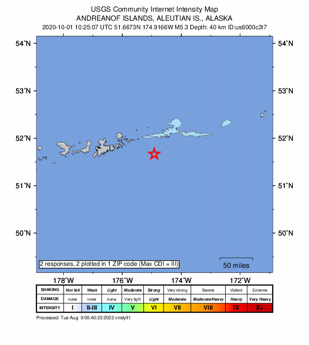
A magnitude 5.3 earthquake struck 76 km SW of Atka, Alaska on Thu, Oct 1, 2020, 1:25 AM HADT (10:25 UTC), 40 km (25 mi) below the surface.
Map
Where this earthquake was located, with the others nearby. Select one for its page.
The earthquake
- Magnitude
- 5.3 (mww), moderate
- Local time
- UTC
- 2020-10-01 10:25:07 UTC
- Depth
- 40.2 km (25.0 mi), shallow
- Epicenter
- 51.667° N, 174.917° W
- Region
- Alaska
- Felt reports
- 2
- Tsunami flag
- No
- Status
- Reviewed by a seismologist
Did you feel it?
2 people reported to the USGS what they felt; the strongest reported shaking was III, weak shaking.
Fault motion and ground failure
How the rock slipped, from the moment tensor, and the USGS estimate of landslides and liquefaction.
- Faulting
- Reverse (thrust)
- Moment magnitude
- 5.3 Mww
- Nodal plane 1
- Strike 265°, dip 31°, rake 112°
- Nodal plane 2
- Strike 59°, dip 61°, rake 77°
How well it is located
Reviewed by a seismologist.
- Location uncertainty
- About 4.9 km horizontally, 4.4 km in depth
- Magnitude uncertainty
- ±0.05
- Depth from
- From location
- Station coverage gap
- 38°
- Stations used
- 147
Nearby
Within 100 km, magnitude 2.3 and up: 51 in the 60 days after this one and 23 in the 30 days before it.
After
- 4.090 km SSW of Atka, Alaska · 2187 days ago · 35 km deep · 19 km away
- 2.586 km SW of Atka, Alaska · 2186 days ago · 34 km deep · 12 km away
- 3.784 km SW of Atka, Alaska · 2186 days ago · 35 km deep · 9 km away · felt by 1
- 2.336 km W of Atka, Alaska · 2186 days ago · 200 km deep · 60 km away
- 3.886 km SW of Atka, Alaska · 2186 days ago · 24 km deep · 11 km away
- 3.044 km SE of Adak, Alaska · 2184 days ago · 59 km deep · 82 km away
- 3.539 km ESE of Atka, Alaska · 2181 days ago · 14 km deep · 99 km away
- 3.164 km SE of Adak, Alaska · 2180 days ago · 35 km deep · 76 km away
- 3.335 km E of Adak, Alaska · 2180 days ago · 89 km deep · 86 km away
- 3.068 km SSE of Adak, Alaska · 2179 days ago · 35 km deep · 91 km away
- 4.368 km SSE of Adak, Alaska · 2179 days ago · 28 km deep · 88 km away
- 2.578 km SSE of Adak, Alaska · 2179 days ago · 35 km deep · 95 km away
- 2.879 km W of Atka, Alaska · 2178 days ago · 228 km deep · 64 km away
- 2.588 km NE of Adak, Alaska · 2177 days ago · 167 km deep · 90 km away
- 3.945 km SE of Atka, Alaska · 2177 days ago · 20 km deep · 88 km away
- 2.926 km WNW of Atka, Alaska · 2177 days ago · 195 km deep · 78 km away
- 3.470 km SE of Adak, Alaska · 2177 days ago · 35 km deep · 70 km away
- 2.580 km NE of Adak, Alaska · 2173 days ago · 167 km deep · 92 km away
- 2.981 km NE of Adak, Alaska · 2172 days ago · 185 km deep · 89 km away
- 2.968 km SE of Adak, Alaska · 2172 days ago · 35 km deep · 72 km away
- 3.175 km ENE of Adak, Alaska · 2172 days ago · 158 km deep · 69 km away
- 2.921 km S of Atka, Alaska · 2171 days ago · 195 km deep · 64 km away
- 2.567 km SSE of Adak, Alaska · 2170 days ago · 33 km deep · 94 km away
- 3.157 km SE of Adak, Alaska · 2170 days ago · 42 km deep · 89 km away
- 2.674 km SSE of Adak, Alaska · 2165 days ago · 35 km deep · 97 km away
- 2.373 km W of Atka, Alaska · 2162 days ago · 239 km deep · 60 km away
- 3.569 km ESE of Adak, Alaska · 2161 days ago · 35 km deep · 56 km away
- 2.516 km NNE of Atka, Alaska · 2159 days ago · 4 km deep · 91 km away
- 2.8Andreanof Islands, Aleutian Islands, Alaska · 2157 days ago · 26 km deep · 92 km away
- 4.258 km SSE of Adak, Alaska · 2157 days ago · 44 km deep · 95 km away
- 3.245 km ENE of Adak, Alaska · 2155 days ago · 133 km deep · 82 km away
- 2.352 km SE of Atka, Alaska · 2153 days ago · 115 km deep · 88 km away
- 3.963 km ESE of Adak, Alaska · 2151 days ago · 65 km deep · 59 km away
- 2.49 km ESE of Atka, Alaska · 2150 days ago · 158 km deep · 80 km away
- 2.365 km SE of Adak, Alaska · 2147 days ago · 25 km deep · 72 km away
- 2.943 km WSW of Atka, Alaska · 2146 days ago · 247 km deep · 46 km away
- 3.520 km ENE of Atka, Alaska · 2146 days ago · 159 km deep · 95 km away
- 3.090 km SSE of Atka, Alaska · 2145 days ago · 10 km deep · 98 km away
- 2.544 km ESE of Adak, Alaska · 2144 days ago · 68 km deep · 76 km away
- 2.863 km SE of Adak, Alaska · 2143 days ago · 35 km deep · 86 km away
- 2.963 km SE of Adak, Alaska · 2143 days ago · 35 km deep · 78 km away
- 3.669 km SSW of Atka, Alaska · 2142 days ago · 25 km deep · 20 km away
- 2.883 km SSW of Atka, Alaska · 2141 days ago · 28 km deep · 37 km away
- 3.668 km ENE of Adak, Alaska · 2139 days ago · 156 km deep · 76 km away
- 2.832 km ENE of Adak, Alaska · 2134 days ago · 137 km deep · 92 km away
- 3.4114 km SE of Adak, Alaska · 2133 days ago · 17 km deep · 87 km away
- 3.293 km SSE of Atka, Alaska · 2133 days ago · 35 km deep · 91 km away
- 2.563 km WSW of Atka, Alaska · 2133 days ago · 57 km deep · 27 km away
- 2.954 km NE of Adak, Alaska · 2133 days ago · 158 km deep · 96 km away
- 3.632 km SE of Adak, Alaska · 2129 days ago · 59 km deep · 98 km away
- 3.1149 km S of Atka, Alaska · 2128 days ago · 22 km deep · 92 km away
Before
- 2.325 km S of Atka, Alaska · 2190 days ago · 145 km deep · 60 km away
- 2.896 km ESE of Adak, Alaska · 2191 days ago · 35 km deep · 48 km away
- 2.840 km SSW of Atka, Alaska · 2191 days ago · 76 km deep · 40 km away
- 3.076 km E of Adak, Alaska · 2193 days ago · 98 km deep · 50 km away
- 3.169 km WSW of Atka, Alaska · 2194 days ago · 75 km deep · 23 km away
- 2.548 km ENE of Adak, Alaska · 2194 days ago · 162 km deep · 79 km away
- 4.026 km NNW of Atka, Alaska · 2196 days ago · 122 km deep · 90 km away
- 3.384 km W of Atka, Alaska · 2196 days ago · 144 km deep · 70 km away
- 2.660 km SSW of Atka, Alaska · 2200 days ago · 30 km deep · 23 km away
- 3.067 km SSE of Adak, Alaska · 2203 days ago · 22 km deep · 89 km away
- 3.875 km SE of Adak, Alaska · 2203 days ago · 26 km deep · 84 km away · felt by 1
- 2.672 km ENE of Adak, Alaska · 2203 days ago · 190 km deep · 65 km away
- 2.637 km NW of Atka, Alaska · 2204 days ago · 220 km deep · 82 km away
- 2.851 km E of Adak, Alaska · 2204 days ago · 80 km deep · 70 km away
- 2.940 km ESE of Atka, Alaska · 2204 days ago · 10 km deep · 99 km away
- 2.678 km WSW of Atka, Alaska · 2204 days ago · 251 km deep · 47 km away
- 2.942 km SE of Atka, Alaska · 2205 days ago · 98 km deep · 81 km away
- 2.64 km SSW of Atka, Alaska · 2205 days ago · 162 km deep · 72 km away
- 2.7Andreanof Islands, Aleutian Islands, Alaska · 2207 days ago · 32 km deep · 75 km away
- 2.787 km SE of Adak, Alaska · 2207 days ago · 26 km deep · 67 km away
Earthquakes todayAlaska earthquakesLive radar here
Sources
From the USGS Earthquake Hazards Program and its partner networks, event us6000c3t7 (also filed as pt20275001, ak020cmyw5da, iscgem619404995). Read Mon, Sep 28, 2026, 2:32 AM UTC.