M3.8 earthquake 75 km SE of Adak, Alaska
A magnitude 3.8 earthquake struck 75 km SE of Adak, Alaska on Tue, Sep 15, 2020, 3:51 PM HADT (00:51 UTC), 26 km (16 mi) below the surface.
A larger quake followed: M5.3 76 km SW of Atka, Alaska. This one was a foreshock.
Map
Where this earthquake was located, with the others nearby. Select one for its page.
The earthquake
- Magnitude
- 3.8 (mb), minor
- Local time
- UTC
- 2020-09-16 00:51:47 UTC
- Depth
- 25.8 km (16.1 mi), shallow
- Epicenter
- 51.327° N, 175.999° W
- Region
- Alaska
- Felt reports
- 1
- Tsunami flag
- No
- Status
- Reviewed by a seismologist
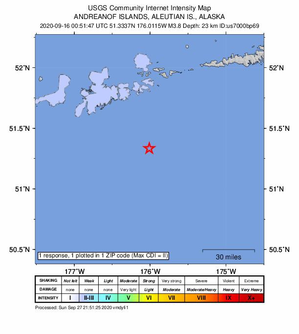
Did you feel it?
1 person reported to the USGS what they felt; the strongest reported shaking was II, weak shaking.
How well it is located
Reviewed by a seismologist.
- Location uncertainty
- About 4.9 km horizontally, 10.3 km in depth
- Magnitude uncertainty
- ±0.12
- Depth from
- From location
- Station coverage gap
- 217°, poorly surrounded by stations
- Stations used
- 56
Nearby
Within 100 km, magnitude 1.5 and up: 125 in the 60 days after this one and 73 in the 30 days before it.
After
- 3.067 km SSE of Adak, Alaska · 2204 days ago · 22 km deep · 9 km away
- 1.662 km SE of Adak, Alaska · 2204 days ago · 24 km deep · 20 km away
- 1.996 km ESE of Adak, Alaska · 2204 days ago · 29 km deep · 57 km away
- 4.051 km SSE of Adak, Alaska · 2203 days ago · 35 km deep · 28 km away
- 1.556 km SSW of Adak, Alaska · 2202 days ago · 25 km deep · 62 km away
- 1.693 km ESE of Adak, Alaska · 2202 days ago · 26 km deep · 54 km away
- 2.056 km SE of Adak, Alaska · 2200 days ago · 32 km deep · 23 km away
- 2.717 km SE of Adak, Alaska · 2199 days ago · 80 km deep · 58 km away
- 2.155 km SSE of Adak, Alaska · 2198 days ago · 26 km deep · 29 km away
- 3.330 km SW of Adak, Alaska · 2198 days ago · 87 km deep · 80 km away
- 1.570 km SSE of Adak, Alaska · 2197 days ago · 21 km deep · 30 km away
- 2.736 km S of Adak, Alaska · 2197 days ago · 47 km deep · 55 km away
- 1.982 km SW of Atka, Alaska · 2197 days ago · 41 km deep · 79 km away
- 1.861 km E of Adak, Alaska · 2196 days ago · 88 km deep · 74 km away
- 1.952 km S of Adak, Alaska · 2196 days ago · 24 km deep · 36 km away
- 1.617 km S of Adak, Alaska · 2196 days ago · 65 km deep · 62 km away
- 1.516 km SSW of Adak, Alaska · 2196 days ago · 78 km deep · 67 km away
- 1.841 km E of Adak, Alaska · 2196 days ago · 133 km deep · 65 km away
- 1.860 km SW of Atka, Alaska · 2196 days ago · 60 km deep · 97 km away
- 2.548 km ENE of Adak, Alaska · 2195 days ago · 162 km deep · 72 km away
- 1.642 km SSW of Adak, Alaska · 2195 days ago · 45 km deep · 62 km away
- 2.438 km SW of Adak, Alaska · 2195 days ago · 72 km deep · 84 km away
- 3.169 km WSW of Atka, Alaska · 2195 days ago · 75 km deep · 88 km away
- 1.678 km SE of Adak, Alaska · 2195 days ago · 26 km deep · 18 km away
- 1.939 km SE of Adak, Alaska · 2195 days ago · 71 km deep · 40 km away
- 3.076 km E of Adak, Alaska · 2194 days ago · 98 km deep · 73 km away
- 1.647 km ENE of Adak, Alaska · 2194 days ago · 90 km deep · 74 km away
- 1.844 km SSE of Adak, Alaska · 2193 days ago · 31 km deep · 33 km away
- 1.658 km SSE of Adak, Alaska · 2193 days ago · 24 km deep · 20 km away
- 1.735 km ESE of Adak, Alaska · 2193 days ago · 84 km deep · 53 km away
- 2.892 km SW of Adak, Alaska · 2192 days ago · 35 km deep · 98 km away
- 2.896 km ESE of Adak, Alaska · 2192 days ago · 35 km deep · 38 km away
- 1.897 km SW of Atka, Alaska · 2192 days ago · 25 km deep · 62 km away
- 1.822 km SSW of Adak, Alaska · 2190 days ago · 68 km deep · 66 km away
- 1.767 km SSW of Adak, Alaska · 2190 days ago · 44 km deep · 78 km away
- 1.960 km SE of Adak, Alaska · 2190 days ago · 23 km deep · 17 km away
- 1.557 km SSE of Adak, Alaska · 2190 days ago · 26 km deep · 27 km away
- 5.376 km SW of Atka, Alaska · 2189 days ago · 40 km deep · 84 km away · felt by 2
- 4.090 km SSW of Atka, Alaska · 2188 days ago · 35 km deep · 81 km away
- 2.434 km S of Adak, Alaska · 2188 days ago · 34 km deep · 55 km away
- 1.683 km SW of Atka, Alaska · 2188 days ago · 26 km deep · 80 km away
- 1.681 km SW of Atka, Alaska · 2187 days ago · 30 km deep · 81 km away
- 2.052 km E of Adak, Alaska · 2187 days ago · 149 km deep · 61 km away
- 2.586 km SW of Atka, Alaska · 2187 days ago · 34 km deep · 79 km away
- 3.784 km SW of Atka, Alaska · 2187 days ago · 35 km deep · 80 km away · felt by 1
- 1.812 km SSE of Adak, Alaska · 2187 days ago · 75 km deep · 64 km away
- 1.586 km SSW of Atka, Alaska · 2187 days ago · 26 km deep · 84 km away
- 1.857 km SE of Adak, Alaska · 2187 days ago · 46 km deep · 18 km away
- 3.353 km S of Adak, Alaska · 2187 days ago · 33 km deep · 44 km away
- 1.881 km SW of Atka, Alaska · 2187 days ago · 18 km deep · 83 km away
- 3.886 km SW of Atka, Alaska · 2186 days ago · 24 km deep · 78 km away
- 1.841 km SSE of Adak, Alaska · 2186 days ago · 31 km deep · 34 km away
- 1.987 km ESE of Adak, Alaska · 2185 days ago · 39 km deep · 36 km away
- 3.044 km SE of Adak, Alaska · 2185 days ago · 59 km deep · 37 km away
- 1.738 km SSW of Adak, Alaska · 2185 days ago · 15 km deep · 65 km away
- 2.659 km SSE of Adak, Alaska · 2185 days ago · 35 km deep · 24 km away
- 1.934 km SSW of Adak, Alaska · 2185 days ago · 57 km deep · 63 km away
- 3.164 km SE of Adak, Alaska · 2181 days ago · 35 km deep · 15 km away
- 3.335 km E of Adak, Alaska · 2181 days ago · 89 km deep · 61 km away
- 1.882 km SW of Atka, Alaska · 2180 days ago · 26 km deep · 83 km away
The first 60 of 125.
Before
- 2.672 km ENE of Adak, Alaska · 2204 days ago · 190 km deep · 86 km away
- 1.551 km S of Adak, Alaska · 2205 days ago · 25 km deep · 44 km away
- 2.270 km E of Adak, Alaska · 2205 days ago · 197 km deep · 75 km away
- 2.851 km E of Adak, Alaska · 2205 days ago · 80 km deep · 55 km away
- 1.651 km SE of Adak, Alaska · 2205 days ago · 45 km deep · 25 km away
- 2.678 km WSW of Atka, Alaska · 2205 days ago · 251 km deep · 90 km away
- 1.852 km S of Adak, Alaska · 2206 days ago · 26 km deep · 38 km away
- 1.587 km ESE of Adak, Alaska · 2207 days ago · 20 km deep · 41 km away
- 1.679 km SE of Adak, Alaska · 2207 days ago · 22 km deep · 14 km away
- 1.540 km SSE of Adak, Alaska · 2207 days ago · 32 km deep · 36 km away
- 1.979 km SSW of Atka, Alaska · 2207 days ago · 13 km deep · 97 km away
- 1.948 km SSE of Adak, Alaska · 2207 days ago · 26 km deep · 35 km away
- 2.7Andreanof Islands, Aleutian Islands, Alaska · 2208 days ago · 32 km deep · 15 km away
- 2.787 km SE of Adak, Alaska · 2208 days ago · 26 km deep · 19 km away
- 1.982 km SE of Adak, Alaska · 2208 days ago · 26 km deep · 14 km away
- 1.875 km SE of Adak, Alaska · 2208 days ago · 23 km deep · 12 km away
- 1.555 km SE of Adak, Alaska · 2209 days ago · 24 km deep · 20 km away
- 1.953 km SE of Adak, Alaska · 2210 days ago · 26 km deep · 21 km away
- 1.537 km S of Adak, Alaska · 2210 days ago · 37 km deep · 51 km away
- 1.743 km SSW of Adak, Alaska · 2210 days ago · 57 km deep · 66 km away
Earthquakes todayAlaska earthquakesLive radar here
Sources
From the USGS Earthquake Hazards Program and its partner networks, event us7000bp69 (also filed as ak020by019qa). Read Tue, Sep 29, 2026, 1:39 AM UTC.