M3.7 earthquake 84 km SW of Atka, Alaska
A magnitude 3.7 earthquake struck 84 km SW of Atka, Alaska on Fri, Oct 2, 2020, 5:33 PM HADT (02:33 UTC), 35 km (22 mi) below the surface.
A larger quake followed: M4.3 68 km SSE of Adak, Alaska. This one was a foreshock.
Map
Where this earthquake was located, with the others nearby. Select one for its page.
The earthquake
- Magnitude
- 3.7 (ml), minor
- Local time
- UTC
- 2020-10-03 02:33:43 UTC
- Depth
- 35.0 km (21.7 mi), shallow
- Epicenter
- 51.584° N, 174.916° W
- Region
- Alaska
- Felt reports
- 1
- Tsunami flag
- No
- Status
- Reviewed by a seismologist
Did you feel it?
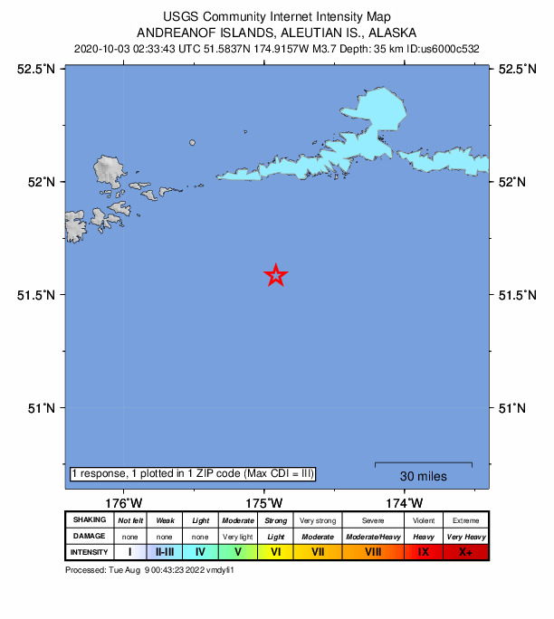
1 person reported to the USGS what they felt; the strongest reported shaking was III, weak shaking.
How well it is located
Reviewed by a seismologist.
- Location uncertainty
- About 5.2 km horizontally, 2.0 km in depth
- Magnitude uncertainty
- ±0.10
- Depth from
- Operator assigned
- Station coverage gap
- 203°, poorly surrounded by stations
- Stations used
- 32
Nearby
Within 100 km, magnitude 1.5 and up: 107 in the 60 days after this one and 73 in the 30 days before it.
After
- 1.7Andreanof Islands, Aleutian Islands, Alaska · 2186 days ago · 7 km deep · 53 km away
- 1.576 km S of Atka, Alaska · 2186 days ago · 22 km deep · 42 km away
- 1.586 km SSW of Atka, Alaska · 2186 days ago · 26 km deep · 9 km away
- 1.857 km SE of Adak, Alaska · 2186 days ago · 46 km deep · 81 km away
- 2.336 km W of Atka, Alaska · 2185 days ago · 200 km deep · 70 km away
- 1.881 km SW of Atka, Alaska · 2185 days ago · 18 km deep · 3 km away
- 3.886 km SW of Atka, Alaska · 2185 days ago · 24 km deep · 3 km away
- 1.749 km S of Atka, Alaska · 2185 days ago · 23 km deep · 59 km away
- 1.841 km SSE of Adak, Alaska · 2185 days ago · 31 km deep · 98 km away
- 1.987 km ESE of Adak, Alaska · 2184 days ago · 39 km deep · 45 km away
- 3.044 km SE of Adak, Alaska · 2184 days ago · 59 km deep · 82 km away
- 2.275 km ENE of Adak, Alaska · 2183 days ago · 170 km deep · 92 km away
- 3.164 km SE of Adak, Alaska · 2180 days ago · 35 km deep · 74 km away
- 3.335 km E of Adak, Alaska · 2180 days ago · 89 km deep · 89 km away
- 2.218 km SE of Atka, Alaska · 2179 days ago · 71 km deep · 85 km away
- 1.882 km SW of Atka, Alaska · 2179 days ago · 26 km deep · 3 km away
- 3.068 km SSE of Adak, Alaska · 2179 days ago · 35 km deep · 88 km away
- 4.368 km SSE of Adak, Alaska · 2179 days ago · 28 km deep · 85 km away
- 2.160 km SSE of Adak, Alaska · 2179 days ago · 24 km deep · 93 km away
- 2.578 km SSE of Adak, Alaska · 2179 days ago · 35 km deep · 91 km away
- 2.879 km W of Atka, Alaska · 2178 days ago · 228 km deep · 73 km away
- 1.742 km ESE of Adak, Alaska · 2177 days ago · 63 km deep · 80 km away
- 1.851 km SSE of Atka, Alaska · 2177 days ago · 25 km deep · 62 km away
- 2.588 km NE of Adak, Alaska · 2177 days ago · 167 km deep · 98 km away
- 1.532 km SE of Adak, Alaska · 2177 days ago · 25 km deep · 95 km away
- 3.945 km SE of Atka, Alaska · 2177 days ago · 20 km deep · 92 km away
- 2.926 km WNW of Atka, Alaska · 2177 days ago · 195 km deep · 87 km away
- 3.470 km SE of Adak, Alaska · 2177 days ago · 35 km deep · 68 km away
- 1.737 km SW of Atka, Alaska · 2176 days ago · 64 km deep · 47 km away
- 2.580 km NE of Adak, Alaska · 2173 days ago · 167 km deep · 100 km away
- 2.981 km NE of Adak, Alaska · 2172 days ago · 185 km deep · 97 km away
- 2.968 km SE of Adak, Alaska · 2172 days ago · 35 km deep · 70 km away
- 1.986 km ENE of Adak, Alaska · 2172 days ago · 113 km deep · 76 km away
- 3.175 km ENE of Adak, Alaska · 2172 days ago · 158 km deep · 76 km away
- 1.826 km SW of Atka, Alaska · 2172 days ago · 72 km deep · 57 km away
- 2.921 km S of Atka, Alaska · 2171 days ago · 195 km deep · 70 km away
- 2.567 km SSE of Adak, Alaska · 2170 days ago · 33 km deep · 91 km away
- 1.659 km SSE of Adak, Alaska · 2170 days ago · 24 km deep · 94 km away
- 3.157 km SE of Adak, Alaska · 2170 days ago · 42 km deep · 87 km away
- 1.615 km NW of Atka, Alaska · 2168 days ago · 180 km deep · 90 km away
- 1.861 km ESE of Adak, Alaska · 2165 days ago · 39 km deep · 65 km away
- 2.674 km SSE of Adak, Alaska · 2165 days ago · 35 km deep · 93 km away
- 1.843 km ENE of Adak, Alaska · 2164 days ago · 8 km deep · 94 km away
- 1.967 km ESE of Adak, Alaska · 2164 days ago · 31 km deep · 62 km away
- 2.079 km E of Adak, Alaska · 2163 days ago · 101 km deep · 55 km away
- 1.6135 km SSE of Adak, Alaska · 2163 days ago · 26 km deep · 94 km away
- 1.723 km WNW of Atka, Alaska · 2163 days ago · 148 km deep · 85 km away
- 1.557 km SSE of Adak, Alaska · 2162 days ago · 26 km deep · 92 km away
- 1.819 km NW of Atka, Alaska · 2162 days ago · 188 km deep · 88 km away
- 1.699 km SSE of Atka, Alaska · 2162 days ago · 26 km deep · 83 km away
- 1.930 km W of Atka, Alaska · 2162 days ago · 199 km deep · 73 km away
- 2.373 km W of Atka, Alaska · 2162 days ago · 239 km deep · 68 km away
- 1.978 km E of Adak, Alaska · 2161 days ago · 68 km deep · 49 km away
- 1.6104 km SSW of Atka, Alaska · 2161 days ago · 5 km deep · 22 km away
- 1.534 km SE of Atka, Alaska · 2161 days ago · 12 km deep · 82 km away
- 1.951 km ESE of Adak, Alaska · 2161 days ago · 59 km deep · 72 km away
- 3.569 km ESE of Adak, Alaska · 2161 days ago · 35 km deep · 56 km away
- 2.516 km NNE of Atka, Alaska · 2159 days ago · 4 km deep · 99 km away
- 2.8Andreanof Islands, Aleutian Islands, Alaska · 2157 days ago · 26 km deep · 85 km away
- 2.285.5 km W of Adak, AK · 2157 days ago · 65 km deep · 44 km away
The first 60 of 107.
Before
- 2.586 km SW of Atka, Alaska · 2186 days ago · 34 km deep · 3 km away
- 2.052 km E of Adak, Alaska · 2186 days ago · 149 km deep · 73 km away
- 1.681 km SW of Atka, Alaska · 2186 days ago · 30 km deep · 4 km away
- 1.683 km SW of Atka, Alaska · 2187 days ago · 26 km deep · 1 km away
- 4.090 km SSW of Atka, Alaska · 2187 days ago · 35 km deep · 10 km away
- 5.376 km SW of Atka, Alaska · 2188 days ago · 40 km deep · 9 km away · felt by 2
- 1.960 km SE of Adak, Alaska · 2189 days ago · 23 km deep · 78 km away
- 1.657 km WSW of Atka, Alaska · 2189 days ago · 74 km deep · 50 km away
- 2.325 km S of Atka, Alaska · 2190 days ago · 145 km deep · 65 km away
- 1.897 km SW of Atka, Alaska · 2191 days ago · 25 km deep · 19 km away
- 2.896 km ESE of Adak, Alaska · 2191 days ago · 35 km deep · 43 km away
- 2.840 km SSW of Atka, Alaska · 2191 days ago · 76 km deep · 45 km away
- 1.735 km ESE of Adak, Alaska · 2191 days ago · 84 km deep · 87 km away
- 1.658 km SSE of Adak, Alaska · 2191 days ago · 24 km deep · 94 km away
- 1.735 km SSE of Atka, Alaska · 2192 days ago · 55 km deep · 78 km away
- 1.844 km SSE of Adak, Alaska · 2192 days ago · 31 km deep · 100 km away
- 1.647 km ENE of Adak, Alaska · 2192 days ago · 90 km deep · 86 km away
- 1.7152 km S of Atka, Alaska · 2192 days ago · 5 km deep · 98 km away
- 1.95 km NW of Atka, Alaska · 2193 days ago · 152 km deep · 86 km away
- 3.076 km E of Adak, Alaska · 2193 days ago · 98 km deep · 56 km away
Earthquakes todayAlaska earthquakesLive radar here
Sources
From the USGS Earthquake Hazards Program and its partner networks, event us6000c532 (also filed as ak020cq595vr). Read Mon, Sep 28, 2026, 12:05 AM UTC.