M1.7 earthquake 50 km SSW of Nanwalek, Alaska
A magnitude 1.7 earthquake struck 50 km SSW of Nanwalek, Alaska on Fri, Aug 16, 2019, 7:34 AM AKDT (15:34 UTC), 60 km (37 mi) below the surface.
A larger quake followed: M3.5 29 km NE of Ouzinkie, Alaska. This one was a foreshock.
Map
Where this earthquake was located, with the others nearby. Select one for its page.
The earthquake
- Magnitude
- 1.7 (ML, local (Richter)), micro
- Magnitude from
- Alaska Earthquake Center
- Local time
- UTC
- 2019-08-16 15:34:10 UTC
- Depth
- 59.6 km (37.0 mi), shallow
- Epicenter
- 58.950° N, 152.304° W
- Region
- Alaska
- Felt reports
- 1
- Tsunami flag
- No
- Status
- Reviewed by a seismologist
Magnitude estimates
Different scales measure different things and differ by a few tenths. The USGS marks one as preferred, and it is the one this page uses.
| Mag. | Scale | Computed by | Notes |
|---|---|---|---|
| 1.7 | ML, local (Richter) | Alaska Earthquake Center | Preferred · Preliminary |
| 1.7 | ML, local (Richter) | AACSE | Preliminary |
Did you feel it?
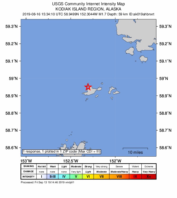
1 person reported to the USGS what they felt; the strongest reported shaking was III, weak shaking.
How well it is located
Reviewed by a seismologist.
- Stations used
- 16
Nearest places
Distance and direction from each place to the epicenter, with its forecast.
Nearby
Within 100 km, magnitude 1.5 and up: 143 in the 60 days after this one and 73 in the 30 days before it.
After
- 1.752 km W of Nanwalek, Alaska · 2605 days ago · 83 km deep · 63 km away
- 1.651 km W of Anchor Point, Alaska · 2605 days ago · 81 km deep · 99 km away
- 2.062 km W of Nanwalek, Alaska · 2604 days ago · 80 km deep · 64 km away
- 2.147 km WNW of Nanwalek, Alaska · 2603 days ago · 73 km deep · 69 km away
- 2.1103 km SSE of Port Graham, Alaska · 2603 days ago · 29 km deep · 93 km away
- 3.155 km E of Pedro Bay, Alaska · 2602 days ago · 100 km deep · 98 km away
- 1.615 km SSW of Halibut Cove, Alaska · 2602 days ago · 5 km deep · 80 km away
- 1.55 km NW of Anchor Point, Alaska · 2602 days ago · 61 km deep · 98 km away
- 1.6Southern Alaska · 2602 days ago · 102 km deep · 99 km away
- 1.763 km WNW of Nanwalek, Alaska · 2602 days ago · 88 km deep · 78 km away
- 1.981 km ENE of Ouzinkie, Alaska · 2602 days ago · 29 km deep · 99 km away
- 1.647 km ESE of Pope-Vannoy Landing, Alaska · 2602 days ago · 103 km deep · 94 km away
- 1.541 km SE of Pedro Bay, Alaska · 2602 days ago · 110 km deep · 97 km away
- 1.583 km WSW of Nanwalek, Alaska · 2601 days ago · 70 km deep · 51 km away
- 1.737 km W of Anchor Point, Alaska · 2601 days ago · 74 km deep · 100 km away
- 1.859 km ESE of Pedro Bay, Alaska · 2599 days ago · 99 km deep · 90 km away
- 1.857 km WNW of Nanwalek, Alaska · 2598 days ago · 84 km deep · 69 km away
- 1.775 km SE of Pope-Vannoy Landing, Alaska · 2598 days ago · 85 km deep · 67 km away
- 2.134 km NW of Nanwalek, Alaska · 2597 days ago · 71 km deep · 68 km away
- 1.716 km W of Anchor Point, AK · 2597 days ago · 63 km deep · 94 km away
- 1.782 km N of Aleneva, Alaska · 2596 days ago · 65 km deep · 53 km away
- 1.558 km WNW of Nanwalek, Alaska · 2596 days ago · 82 km deep · 69 km away
- 1.562 km SE of Kokhanok, Alaska · 2596 days ago · 108 km deep · 96 km away
- 1.861 km SSW of Nanwalek, Alaska · 2594 days ago · 66 km deep · 11 km away
- 1.540 km NW of Nanwalek, Alaska · 2594 days ago · 67 km deep · 72 km away
- 1.646 km SW of Nanwalek, Alaska · 2594 days ago · 77 km deep · 20 km away
- 1.851 km ESE of Pedro Bay, Alaska · 2594 days ago · 112 km deep · 88 km away
- 1.864 km N of Aleneva, Alaska · 2593 days ago · 47 km deep · 42 km away
- 2.075 km NNW of Aleneva, Alaska · 2592 days ago · 59 km deep · 60 km away
- 1.932 km WSW of Nanwalek, Alaska · 2591 days ago · 69 km deep · 32 km away
- 1.554 km WNW of Nanwalek, Alaska · 2591 days ago · 15 km deep · 67 km away
- 1.671 km WSW of Nanwalek, Alaska · 2591 days ago · 61 km deep · 54 km away
- 1.753 km SW of Nanwalek, Alaska · 2590 days ago · 55 km deep · 11 km away
- 1.964 km ESE of Pedro Bay, Alaska · 2590 days ago · 106 km deep · 79 km away
- 2.024 km WNW of Anchor Point, Alaska · 2590 days ago · 73 km deep · 98 km away
- 2.038 km WSW of Anchor Point, Alaska · 2589 days ago · 68 km deep · 82 km away
- 2.540 km NNE of Aleneva, AK · 2588 days ago · 46 km deep · 66 km away · felt by 2
- 1.7Kodiak Island region, Alaska · 2588 days ago · 8 km deep · 76 km away
- 2.539 km WSW of Nanwalek, Alaska · 2588 days ago · 70 km deep · 40 km away · felt by 1
- 2.561 km SE of Pope-Vannoy Landing, Alaska · 2588 days ago · 107 km deep · 82 km away · felt by 1
- 2.147 km W of Anchor Point, Alaska · 2587 days ago · 88 km deep · 91 km away
- 1.955 km W of Anchor Point, Alaska · 2587 days ago · 88 km deep · 97 km away
- 1.553 km E of Pedro Bay, Alaska · 2587 days ago · 109 km deep · 99 km away
- 3.529 km NE of Ouzinkie, Alaska · 2586 days ago · 45 km deep · 94 km away · felt by 14
- 1.864 km ESE of Pedro Bay, Alaska · 2586 days ago · 105 km deep · 80 km away
- 3.414 km NNW of Aleneva, Alaska · 2585 days ago · 48 km deep · 94 km away
- 1.676 km NW of Aleneva, Alaska · 2585 days ago · 2 km deep · 96 km away
- 1.874 km SE of Pedro Bay, Alaska · 2585 days ago · 102 km deep · 65 km away
- 1.758 km WNW of Nanwalek, Alaska · 2585 days ago · 82 km deep · 79 km away
- 1.557 km NNW of Aleneva, Alaska · 2585 days ago · 65 km deep · 81 km away
- 1.630 km W of Anchor Point, Alaska · 2584 days ago · 74 km deep · 97 km away
- 1.961 km SE of Pedro Bay, Alaska · 2584 days ago · -1 km deep · 79 km away
- 1.850 km SW of Nanwalek, Alaska · 2583 days ago · 56 km deep · 10 km away
- 2.350 km NW of Aleneva, Alaska · 2583 days ago · 62 km deep · 99 km away
- 1.874 km N of Aleneva, Alaska · 2583 days ago · 56 km deep · 44 km away
- 1.918 km NNW of Aleneva, Alaska · 2583 days ago · 38 km deep · 92 km away
- 1.962 km NNE of Aleneva, Alaska · 2582 days ago · 40 km deep · 44 km away
- 2.338 km W of Anchor Point, Alaska · 2582 days ago · 72 km deep · 96 km away
- 1.945 km W of Anchor Point, Alaska · 2581 days ago · 98 km deep · 91 km away
- 1.647 km W of Anchor Point, Alaska · 2581 days ago · 95 km deep · 96 km away
The first 60 of 143.
Before
- 2.429 km SSE of Port Graham, Alaska · 2605 days ago · 59 km deep · 41 km away
- 1.563 km E of Pedro Bay, Alaska · 2606 days ago · 90 km deep · 95 km away
- 1.838 km SW of Nanwalek, Alaska · 2606 days ago · 60 km deep · 16 km away
- 1.760 km NNE of Aleneva, Alaska · 2606 days ago · 42 km deep · 48 km away
- 1.664 km ESE of Pedro Bay, Alaska · 2606 days ago · 87 km deep · 79 km away
- 3.012 km SW of Nanwalek, Alaska · 2606 days ago · 56 km deep · 38 km away
- 1.774 km SW of Nanwalek, Alaska · 2606 days ago · 69 km deep · 37 km away
- 1.631 km NNE of Ouzinkie, Alaska · 2606 days ago · 63 km deep · 87 km away
- 1.958 km WSW of Anchor Point, Alaska · 2606 days ago · 83 km deep · 82 km away · felt by 1
- 1.682 km WSW of Nanwalek, Alaska · 2606 days ago · 67 km deep · 52 km away
- 2.083 km NNW of Aleneva, Alaska · 2607 days ago · 4 km deep · 74 km away
- 1.622 km W of Nanwalek, Alaska · 2607 days ago · 67 km deep · 48 km away
- 1.858 km ESE of Pedro Bay, Alaska · 2608 days ago · 102 km deep · 91 km away
- 1.644 km WNW of Nanwalek, Alaska · 2608 days ago · 76 km deep · 66 km away
- 2.764 km ESE of Pedro Bay, Alaska · 2609 days ago · 110 km deep · 80 km away
- 1.766 km NE of Ouzinkie, Alaska · 2609 days ago · 1 km deep · 86 km away
- 1.544 km WSW of Nanwalek, Alaska · 2609 days ago · 71 km deep · 41 km away · felt by 1
- 1.851 km SE of Pope-Vannoy Landing, Alaska · 2610 days ago · 127 km deep · 92 km away
- 2.151 km SE of Pedro Bay, Alaska · 2610 days ago · 109 km deep · 87 km away
- 1.519 km WSW of Nanwalek, Alaska · 2610 days ago · 67 km deep · 35 km away
Earthquakes todayAlaska earthquakesLive radar here
Sources
From the USGS Earthquake Hazards Program and its partner networks, event ak019ahbnxrt (also filed as aacse019ahbnxrt). Read Sat, Oct 3, 2026, 6:03 PM UTC.