M2.5 earthquake 40 km NNE of Aleneva, AK
A magnitude 2.5 earthquake struck 40 km NNE of Aleneva, AK on Mon, Sep 2, 2019, 1:57 AM AKDT (09:57 UTC), 46 km (29 mi) below the surface.
A larger quake followed: M3.5 29 km NE of Ouzinkie, Alaska. This one was a foreshock.
Map
Where this earthquake was located, with the others nearby. Select one for its page.
The earthquake
- Magnitude
- 2.5 (ml), micro
- Local time
- UTC
- 2019-09-02 09:57:20 UTC
- Depth
- 46.2 km (28.7 mi), shallow
- Epicenter
- 58.405° N, 152.745° W
- Region
- Alaska
- Felt reports
- 2
- Tsunami flag
- No
- Status
- Reviewed by a seismologist
Did you feel it?
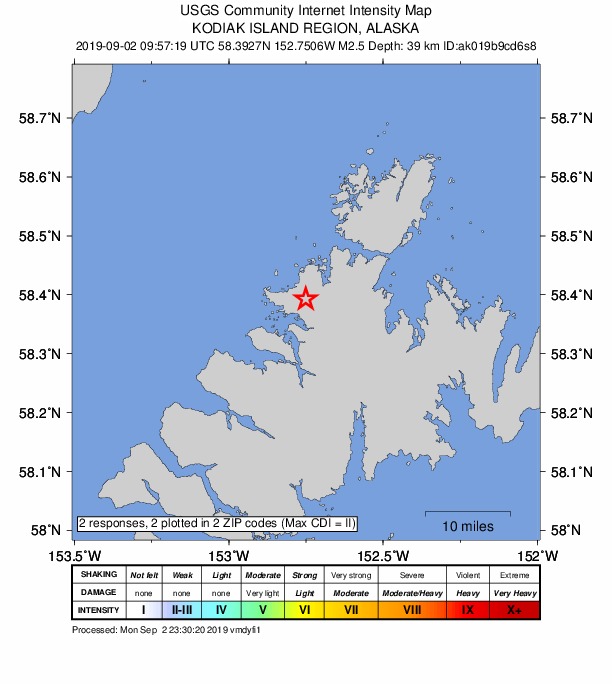
2 people reported to the USGS what they felt; the strongest reported shaking was II, weak shaking.
How well it is located
Reviewed by a seismologist.
- Stations used
- 53
Nearest places
Distance and direction from each place to the epicenter, with its forecast.
Nearby
Within 100 km, magnitude 1.5 and up: 80 in the 60 days after this one and 36 in the 30 days before it.
After
- 1.7Kodiak Island region, Alaska · 2583 days ago · 8 km deep · 66 km away
- 2.539 km WSW of Nanwalek, Alaska · 2582 days ago · 70 km deep · 98 km away · felt by 1
- 3.529 km NE of Ouzinkie, Alaska · 2581 days ago · 45 km deep · 48 km away · felt by 14
- 3.414 km NNW of Aleneva, Alaska · 2580 days ago · 48 km deep · 28 km away
- 1.676 km NW of Aleneva, Alaska · 2580 days ago · 2 km deep · 64 km away
- 1.557 km NNW of Aleneva, Alaska · 2579 days ago · 65 km deep · 41 km away
- 1.850 km SW of Nanwalek, Alaska · 2578 days ago · 56 km deep · 68 km away
- 2.350 km NW of Aleneva, Alaska · 2578 days ago · 62 km deep · 48 km away
- 1.874 km N of Aleneva, Alaska · 2578 days ago · 56 km deep · 38 km away
- 1.918 km NNW of Aleneva, Alaska · 2577 days ago · 38 km deep · 27 km away
- 1.962 km NNE of Aleneva, Alaska · 2577 days ago · 40 km deep · 25 km away
- 2.991 km ENE of Ouzinkie, Alaska · 2577 days ago · 6 km deep · 96 km away
- 2.268 km W of Aleneva, Alaska · 2576 days ago · 65 km deep · 81 km away
- 1.570 km SW of Nanwalek, Alaska · 2576 days ago · 62 km deep · 57 km away
- 2.372 km ENE of Ouzinkie, Alaska · 2574 days ago · 3 km deep · 79 km away
- 1.897 km N of Karluk, Alaska · 2571 days ago · 2 km deep · 100 km away
- 1.674 km SW of Nanwalek, Alaska · 2570 days ago · 67 km deep · 66 km away
- 1.666 km WNW of Aleneva, Alaska · 2570 days ago · 69 km deep · 76 km away
- 3.283 km WNW of Aleneva, Alaska · 2569 days ago · 85 km deep · 83 km away
- 1.677 km WSW of Nanwalek, Alaska · 2568 days ago · 72 km deep · 77 km away
- 1.590 km NNW of Aleneva, Alaska · 2568 days ago · 12 km deep · 69 km away
- 1.861 km NNW of Aleneva, Alaska · 2567 days ago · 68 km deep · 34 km away
- 2.169 km WNW of Aleneva, Alaska · 2566 days ago · 70 km deep · 76 km away
- 1.86 km S of Kodiak, Alaska · 2565 days ago · 47 km deep · 78 km away
- 1.577 km SSE of Port Graham, Alaska · 2565 days ago · 28 km deep · 86 km away
- 2.382 km ENE of Ouzinkie, Alaska · 2565 days ago · 1 km deep · 84 km away
- 1.971 km NW of Aleneva, Alaska · 2562 days ago · 79 km deep · 67 km away
- 1.624 km SSW of Nanwalek, Alaska · 2561 days ago · 56 km deep · 91 km away
- 2.075 km SSW of Nanwalek, Alaska · 2560 days ago · 50 km deep · 42 km away
- 1.781 km NW of Aleneva, Alaska · 2559 days ago · 77 km deep · 67 km away
- 2.050 km NE of Ouzinkie, Alaska · 2556 days ago · 6 km deep · 60 km away
- 1.9Southern Alaska · 2556 days ago · 79 km deep · 84 km away
- 3.165 km WNW of Aleneva, Alaska · 2556 days ago · 2 km deep · 75 km away
- 1.883 km WSW of Nanwalek, Alaska · 2555 days ago · 64 km deep · 69 km away
- 2.156 km NNE of Karluk, Alaska · 2554 days ago · 60 km deep · 94 km away
- 2.086 km NNW of Aleneva, Alaska · 2553 days ago · 6 km deep · 64 km away
- 1.787 km NNW of Aleneva, Alaska · 2553 days ago · 76 km deep · 59 km away
- 1.683 km N of Aleneva, Alaska · 2552 days ago · 79 km deep · 49 km away
- 1.837 km SSW of Nanwalek, Alaska · 2552 days ago · 54 km deep · 79 km away
- 2.938 km SSW of Nanwalek, Alaska · 2551 days ago · 52 km deep · 78 km away · felt by 1
- 1.588 km NNW of Aleneva, Alaska · 2550 days ago · 10 km deep · 64 km away
- 1.663 km S of Port Graham, Alaska · 2550 days ago · 40 km deep · 70 km away
- 1.574 km SE of Kokhanok, Alaska · 2549 days ago · 93 km deep · 91 km away
- 2.178 km SSW of Nanwalek, Alaska · 2549 days ago · 58 km deep · 41 km away
- 1.968 km W of Aleneva, Alaska · 2548 days ago · 66 km deep · 80 km away
- 1.554 km W of Aleneva, Alaska · 2547 days ago · 65 km deep · 75 km away
- 1.586 km ENE of Ouzinkie, Alaska · 2547 days ago · 10 km deep · 90 km away
- 1.932 km WSW of Nanwalek, Alaska · 2546 days ago · 63 km deep · 91 km away
- 1.648 km SW of Nanwalek, Alaska · 2545 days ago · 68 km deep · 78 km away
- 1.621 km WSW of Womens Bay, Alaska · 2545 days ago · 28 km deep · 91 km away
- 2.389 km SW of Nanwalek, Alaska · 2544 days ago · 76 km deep · 63 km away
- 3.367 km SW of Nanwalek, Alaska · 2544 days ago · 61 km deep · 69 km away · felt by 1
- 2.535 km S of Port Graham, Alaska · 2542 days ago · 53 km deep · 91 km away
- 2.366 km SW of Nanwalek, Alaska · 2542 days ago · 62 km deep · 61 km away · felt by 1
- 1.574 km NNE of Aleneva, Alaska · 2542 days ago · 71 km deep · 35 km away
- 3.156 km SSW of Nanwalek, Alaska · 2542 days ago · 57 km deep · 60 km away · felt by 3
- 1.662 km WNW of Aleneva, Alaska · 2541 days ago · 75 km deep · 70 km away
- 2.058 km WSW of Nanwalek, Alaska · 2541 days ago · 67 km deep · 77 km away
- 1.725 km NNE of Aleneva, Alaska · 2539 days ago · 49 km deep · 14 km away
- 1.737 km E of Larsen Bay, Alaska · 2539 days ago · 35 km deep · 99 km away
The first 60 of 80.
Before
- 1.542 km N of Larsen Bay, Alaska · 2584 days ago · 2 km deep · 85 km away
- 2.148 km WNW of Aleneva, Alaska · 2584 days ago · 64 km deep · 63 km away
- 1.753 km SW of Nanwalek, Alaska · 2585 days ago · 55 km deep · 65 km away
- 1.671 km WSW of Nanwalek, Alaska · 2585 days ago · 61 km deep · 90 km away
- 1.576 km SSE of Kokhanok, Alaska · 2585 days ago · 82 km deep · 94 km away
- 1.932 km WSW of Nanwalek, Alaska · 2586 days ago · 69 km deep · 94 km away
- 2.075 km NNW of Aleneva, Alaska · 2586 days ago · 59 km deep · 45 km away
- 1.643 km WNW of Aleneva, Alaska · 2587 days ago · 66 km deep · 49 km away
- 2.169 km WNW of Aleneva, Alaska · 2587 days ago · 72 km deep · 79 km away
- 1.864 km N of Aleneva, Alaska · 2588 days ago · 47 km deep · 26 km away
- 1.646 km SW of Nanwalek, Alaska · 2589 days ago · 77 km deep · 76 km away
- 1.861 km SSW of Nanwalek, Alaska · 2589 days ago · 66 km deep · 55 km away
- 1.782 km N of Aleneva, Alaska · 2591 days ago · 65 km deep · 49 km away
- 1.677 km WNW of Aleneva, Alaska · 2591 days ago · 80 km deep · 78 km away
- 1.775 km SE of Pope-Vannoy Landing, Alaska · 2593 days ago · 85 km deep · 94 km away
- 1.583 km WSW of Nanwalek, Alaska · 2596 days ago · 70 km deep · 70 km away
- 1.981 km ENE of Ouzinkie, Alaska · 2596 days ago · 29 km deep · 88 km away
- 1.814 km ENE of Chiniak, Alaska · 2598 days ago · 19 km deep · 91 km away
- 1.750 km SSW of Nanwalek, Alaska · 2600 days ago · 60 km deep · 66 km away · felt by 1
- 1.638 km W of Port Lions, Alaska · 2600 days ago · 44 km deep · 75 km away
Earthquakes todayAlaska earthquakesLive radar here
Sources
From the USGS Earthquake Hazards Program and its partner networks, event ak019b9cd6s8 (also filed as us70005b5w). Read Mon, Sep 28, 2026, 10:18 AM UTC.