M3.1 earthquake 56 km SSW of Nanwalek, Alaska
A magnitude 3.1 earthquake struck 56 km SSW of Nanwalek, Alaska on Sun, Oct 13, 2019, 10:38 AM AKDT (18:38 UTC), 57 km (35 mi) below the surface.
A larger quake followed: M4.5 56 km WNW of Nanwalek, Alaska. This one was a foreshock.
Map
Where this earthquake was located, with the others nearby. Select one for its page.
The earthquake
- Magnitude
- 3.1 (ML, local (Richter)), minor
- Magnitude from
- Alaska Earthquake Center
- Local time
- UTC
- 2019-10-13 18:38:33 UTC
- Depth
- 56.9 km (35.4 mi), shallow
- Epicenter
- 58.905° N, 152.371° W
- Region
- Alaska
- Felt reports
- 3
- Tsunami flag
- No
- Status
- Reviewed by a seismologist
Magnitude estimates
Different scales measure different things and differ by a few tenths. The USGS marks one as preferred, and it is the one this page uses.
| Mag. | Scale | Computed by | Notes |
|---|---|---|---|
| 3.1 | ML, local (Richter) | Alaska Earthquake Center | Preferred · Preliminary |
| 3.1 | ML, local (Richter) | USGS National Earthquake Information Center | Reviewed |
Did you feel it?
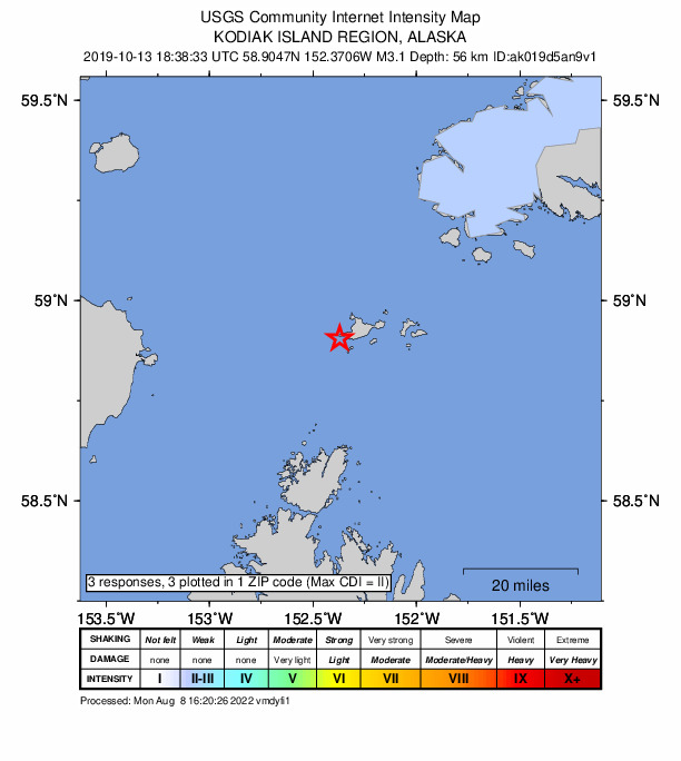
3 people reported to the USGS what they felt; the strongest reported shaking was II, weak shaking.
How well it is located
Reviewed by a seismologist.
- Stations used
- 134
Nearest places
Distance and direction from each place to the epicenter, with its forecast.
Nearby
Within 100 km, magnitude 1.5 and up: 146 in the 60 days after this one and 70 in the 30 days before it.
After
- 2.058 km WSW of Nanwalek, Alaska · 2548 days ago · 67 km deep · 33 km away
- 1.761 km WNW of Nanwalek, Alaska · 2547 days ago · 92 km deep · 80 km away
- 2.049 km ESE of Pedro Bay, Alaska · 2547 days ago · 103 km deep · 93 km away
- 1.918 km W of Nanwalek, Alaska · 2546 days ago · 48 km deep · 49 km away
- 2.049 km WNW of Nanwalek, Alaska · 2546 days ago · 74 km deep · 64 km away
- 1.725 km NNE of Aleneva, Alaska · 2546 days ago · 49 km deep · 73 km away
- 1.865 km WNW of Nanwalek, Alaska · 2546 days ago · 92 km deep · 81 km away
- 1.560 km SSW of Nanwalek, Alaska · 2546 days ago · 13 km deep · 5 km away
- 1.9Southern Alaska · 2545 days ago · 95 km deep · 98 km away
- 2.977 km ENE of Ouzinkie, Alaska · 2545 days ago · 8 km deep · 92 km away
- 1.830 km NW of Nanwalek, Alaska · 2545 days ago · 56 km deep · 74 km away
- 1.756 km ESE of Pedro Bay, Alaska · 2545 days ago · 99 km deep · 95 km away
- 2.544 km W of Anchor Point, Alaska · 2545 days ago · 92 km deep · 91 km away
- 1.569 km WSW of Nanwalek, Alaska · 2544 days ago · 76 km deep · 52 km away
- 1.817 km WNW of Nanwalek, Alaska · 2544 days ago · 64 km deep · 56 km away
- 2.459 km W of Anchor Point, Alaska · 2544 days ago · 99 km deep · 99 km away
- 1.953 km SE of Pedro Bay, Alaska · 2544 days ago · 110 km deep · 86 km away
- 1.956 km W of Nanwalek, Alaska · 2544 days ago · 79 km deep · 66 km away
- 1.877 km ENE of Ouzinkie, Alaska · 2544 days ago · 27 km deep · 94 km away
- 1.740 km SSW of Nanwalek, Alaska · 2543 days ago · 70 km deep · 17 km away
- 2.223 km W of Anchor Point, Alaska · 2543 days ago · 65 km deep · 97 km away
- 1.788 km NW of Aleneva, Alaska · 2543 days ago · 79 km deep · 92 km away
- 1.536 km SSW of Nanwalek, Alaska · 2543 days ago · 59 km deep · 22 km away
- 1.653 km WNW of Nanwalek, Alaska · 2543 days ago · 93 km deep · 71 km away
- 1.848 km W of Nanwalek, Alaska · 2543 days ago · 76 km deep · 52 km away
- 1.67 km NW of Seldovia, Alaska · 2543 days ago · 59 km deep · 72 km away
- 1.640 km WNW of Nanwalek, Alaska · 2542 days ago · 85 km deep · 67 km away
- 1.64 km SE of Seldovia Village, Alaska · 2542 days ago · 47 km deep · 75 km away
- 2.163 km WNW of Nanwalek, Alaska · 2541 days ago · 98 km deep · 80 km away
- 1.663 km WSW of Nanwalek, Alaska · 2541 days ago · 73 km deep · 48 km away
- 1.595 km ENE of Ouzinkie, Alaska · 2541 days ago · 9 km deep · 94 km away
- 1.835 km NW of Nanwalek, Alaska · 2541 days ago · 69 km deep · 73 km away
- 2.455 km SE of Pedro Bay, Alaska · 2540 days ago · 102 km deep · 84 km away
- 1.830 km WSW of Nanwalek, Alaska · 2540 days ago · 67 km deep · 36 km away
- 2.036 km W of Nanwalek, Alaska · 2540 days ago · 75 km deep · 53 km away
- 2.067 km W of Nanwalek, Alaska · 2540 days ago · 106 km deep · 75 km away
- 1.754 km W of Nanwalek, Alaska · 2539 days ago · 79 km deep · 53 km away
- 1.957 km SE of Pope-Vannoy Landing, Alaska · 2539 days ago · 100 km deep · 83 km away
- 1.923 km W of Nanwalek, Alaska · 2538 days ago · 84 km deep · 52 km away
- 1.836 km WSW of Anchor Point, Alaska · 2537 days ago · 67 km deep · 80 km away
- 3.661 km W of Anchor Point, Alaska · 2537 days ago · 101 km deep · 93 km away · felt by 1
- 2.757 km NNE of Aleneva, Alaska · 2536 days ago · 46 km deep · 44 km away
- 1.828 km WNW of Nanwalek, Alaska · 2534 days ago · 61 km deep · 60 km away
- 1.634 km W of Nanwalek, Alaska · 2533 days ago · 70 km deep · 45 km away
- 1.76 km SW of Anchor Point, Alaska · 2533 days ago · 63 km deep · 96 km away
- 1.636 km WNW of Nanwalek, Alaska · 2532 days ago · 74 km deep · 66 km away
- 1.521 km SW of Nanwalek, Alaska · 2532 days ago · 56 km deep · 36 km away
- 1.544 km WNW of Nanwalek, Alaska · 2531 days ago · 87 km deep · 64 km away
- 1.667 km ENE of Ouzinkie, Alaska · 2531 days ago · 11 km deep · 91 km away
- 1.958 km SW of Nanwalek, Alaska · 2531 days ago · 50 km deep · 8 km away
- 1.845 km ESE of Pedro Bay, Alaska · 2529 days ago · 106 km deep · 98 km away
- 2.152 km W of Anchor Point, Alaska · 2529 days ago · 92 km deep · 96 km away
- 1.663 km ESE of Pedro Bay, Alaska · 2529 days ago · 91 km deep · 86 km away
- 1.957 km SW of Nanwalek, Alaska · 2529 days ago · 60 km deep · 16 km away
- 2.673 km SE of Pope-Vannoy Landing, Alaska · 2528 days ago · 91 km deep · 69 km away
- 1.615 km WNW of Nanwalek, Alaska · 2527 days ago · 49 km deep · 56 km away
- 2.562 km WSW of Nanwalek, Alaska · 2527 days ago · 78 km deep · 51 km away
- 2.120 km W of Anchor Point, Alaska · 2526 days ago · 63 km deep · 95 km away
- 2.952 km W of Nanwalek, Alaska · 2526 days ago · 77 km deep · 60 km away · felt by 1
- 1.783 km WSW of Nanwalek, Alaska · 2525 days ago · 8 km deep · 51 km away
The first 60 of 146.
Before
- 1.574 km NNE of Aleneva, Alaska · 2549 days ago · 71 km deep · 26 km away
- 1.756 km ESE of Pedro Bay, Alaska · 2549 days ago · 115 km deep · 94 km away
- 2.366 km SW of Nanwalek, Alaska · 2549 days ago · 62 km deep · 23 km away · felt by 1
- 2.535 km S of Port Graham, Alaska · 2549 days ago · 53 km deep · 39 km away
- 1.860 km WNW of Nanwalek, Alaska · 2549 days ago · 101 km deep · 75 km away
- 3.367 km SW of Nanwalek, Alaska · 2551 days ago · 61 km deep · 33 km away · felt by 1
- 2.722 km SE of Port Graham, Alaska · 2551 days ago · 39 km deep · 60 km away
- 2.389 km SW of Nanwalek, Alaska · 2551 days ago · 76 km deep · 49 km away
- 1.810 km NW of Nanwalek, Alaska · 2551 days ago · 53 km deep · 60 km away
- 1.6Southern Alaska · 2552 days ago · 62 km deep · 76 km away
- 1.648 km SW of Nanwalek, Alaska · 2552 days ago · 68 km deep · 26 km away
- 2.052 km SSE of Port Graham, Alaska · 2552 days ago · 40 km deep · 59 km away
- 1.932 km WSW of Nanwalek, Alaska · 2552 days ago · 63 km deep · 34 km away
- 2.268 km SE of Pedro Bay, Alaska · 2553 days ago · 83 km deep · 71 km away
- 2.145 km WSW of Anchor Point, Alaska · 2553 days ago · 81 km deep · 89 km away
- 3.554 km E of Pedro Bay, Alaska · 2553 days ago · 104 km deep · 99 km away
- 1.586 km ENE of Ouzinkie, Alaska · 2554 days ago · 10 km deep · 96 km away
- 1.58 km WNW of Seldovia, Alaska · 2554 days ago · 58 km deep · 71 km away
- 1.547 km W of Anchor Point, Alaska · 2554 days ago · 85 km deep · 95 km away
- 2.117 km S of Nanwalek, Alaska · 2554 days ago · 44 km deep · 42 km away
Earthquakes todayAlaska earthquakesLive radar here
Sources
From the USGS Earthquake Hazards Program and its partner networks, event ak019d5an9v1 (also filed as us70005twt). Read Mon, Oct 5, 2026, 3:27 AM UTC.