M1.6 earthquake 6 km WNW of Lehi, Utah
A magnitude 1.6 earthquake struck 6 km WNW of Lehi, Utah on Sat, Dec 13, 2025, 4:42 AM MST (11:42 UTC), 2 km (1 mi) below the surface.
A larger quake followed: M3.5 6 km WNW of Lehi, Utah. This one was a foreshock.
Map
Where this earthquake was located, with the others nearby. Select one for its page.
The earthquake
- Magnitude
- 1.6 (ML, local (Richter)), micro
- Magnitude from
- University of Utah Seismograph Stations
- Local time
- UTC
- 2025-12-13 11:42:40 UTC
- Depth
- 1.6 km (1.0 mi), shallow
- Epicenter
- 40.413° N, 111.928° W
- Region
- Utah
- Felt reports
- 17
- Tsunami flag
- No
- Status
- Reviewed by a seismologist
Magnitude estimates
Different scales measure different things and differ by a few tenths. The USGS marks one as preferred, and it is the one this page uses.
| Mag. | Scale | Computed by | Notes |
|---|---|---|---|
| 1.59 | ML, local (Richter) | University of Utah Seismograph Stations | Preferred · Final · ±0.274165182217019 · 3 stations |
| 1.7 | ML, local (Richter) | USGS National Earthquake Information Center | Reviewed · ±0.046 · 61 stations |
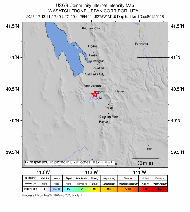
Did you feel it?
17 people reported to the USGS what they felt; the strongest reported shaking was III, weak shaking.
How well it is located
Reviewed by a seismologist.
- Location uncertainty
- About 0.3 km horizontally, 1.2 km in depth
- Magnitude uncertainty
- ±0.27
- Depth from
- From location
- Station coverage gap
- 91°
- Stations used
- 34
Nearest places
Distance and direction from each place to the epicenter, with its forecast.
Nearby
Within 100 km, magnitude 1.5 and up: 17 in the 60 days after this one and 3 in the 30 days before it.
After
- 2.07 km NNW of Saratoga Springs, Utah · 293 days ago · 4 km deep · 0 km away · felt by 73
- 1.92 km WSW of Fairview, Utah · 286 days ago · 6 km deep · 97 km away
- 1.61 km WSW of Fairview, Utah · 286 days ago · 4 km deep · 97 km away
- 1.610 km SW of Nephi, Utah · 275 days ago · 9 km deep · 85 km away
- 1.512 km ENE of Fairview, Utah · 275 days ago · 2 km deep · 99 km away
- 2.310 km SW of Nephi, Utah · 275 days ago · 6 km deep · 85 km away
- 3.313 km E of Huntsville, Utah · 272 days ago · 10 km deep · 100 km away · felt by 267
- 1.65 km NE of Magna, Utah · 266 days ago · 10 km deep · 38 km away
- 2.025 km SSE of Independence, Utah · 256 days ago · 10 km deep · 78 km away
- 1.524 km SSE of Independence, Utah · 255 days ago · 12 km deep · 77 km away
- 2.225 km SSE of Independence, Utah · 255 days ago · 8 km deep · 78 km away
- 1.825 km SSE of Independence, Utah · 254 days ago · 3 km deep · 78 km away
- 2.424 km SSE of Independence, Utah · 254 days ago · 10 km deep · 78 km away · felt by 1
- 1.924 km SSE of Independence, Utah · 247 days ago · 10 km deep · 78 km away
- 1.76 km WNW of Lehi, Utah · 244 days ago · 6 km deep · 1 km away
- 3.56 km WNW of Lehi, Utah · 240 days ago · 6 km deep · 0 km away · felt by 2,906
- 2.07 km NNW of Saratoga Springs, Utah · 240 days ago · 5 km deep · 1 km away · felt by 26
Before
Earthquakes todayUtah earthquakesLive radar here
Sources
From the USGS Earthquake Hazards Program and its partner networks, event uu80124906 (also filed as us6000run3). Read Sat, Oct 3, 2026, 9:54 PM UTC.