M2.4 earthquake 24 km SSE of Independence, Utah
A magnitude 2.4 earthquake struck 24 km SSE of Independence, Utah on Thu, Jan 22, 2026, 7:19 PM MST (02:19 UTC), 10 km (6 mi) below the surface.
A larger quake followed: M3.5 6 km WNW of Lehi, Utah. This one was a foreshock.
Map
Where this earthquake was located, with the others nearby. Select one for its page.
The earthquake
- Magnitude
- 2.4 (Md, duration), micro
- Magnitude from
- University of Utah Seismograph Stations
- Local time
- UTC
- 2026-01-23 02:19:51 UTC
- Depth
- 10.0 km (6.2 mi), shallow
- Epicenter
- 40.114° N, 111.099° W
- Region
- Utah
- Felt reports
- 1
- Tsunami flag
- No
- Status
- Reviewed by a seismologist
Did you feel it?
1 person reported to the USGS what they felt.
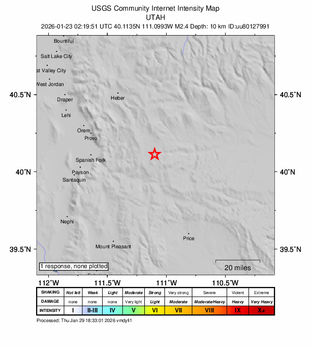
How well it is located
Reviewed by a seismologist.
- Location uncertainty
- About 0.4 km horizontally, 1.1 km in depth
- Magnitude uncertainty
- ±0.31
- Depth from
- From location
- Station coverage gap
- 56°
- Stations used
- 33
Nearest places
Distance and direction from each place to the epicenter, with its forecast.
Nearby
Within 100 km, magnitude 1.5 and up: 28 in the 60 days after this one and 15 in the 30 days before it.
After
- 1.66 km WSW of Clear Creek, Utah · 244 days ago · -1 km deep · 55 km away
- 1.924 km SSE of Independence, Utah · 244 days ago · 10 km deep · 0 km away
- 1.56 km S of Clear Creek, Utah · 244 days ago · 0 km deep · 59 km away
- 1.76 km WNW of Lehi, Utah · 241 days ago · 6 km deep · 77 km away
- 2.242 km ENE of Oakley, Utah · 240 days ago · 15 km deep · 89 km away
- 2.17 km WSW of Clear Creek, Utah · 240 days ago · -1 km deep · 56 km away
- 2.27 km WSW of Clear Creek, Utah · 240 days ago · -2 km deep · 57 km away
- 1.67 km WSW of Clear Creek, Utah · 239 days ago · -2 km deep · 56 km away
- 2.741 km ENE of Oakley, Utah · 238 days ago · 12 km deep · 89 km away · felt by 2
- 3.56 km WNW of Lehi, Utah · 238 days ago · 6 km deep · 78 km away · felt by 2,906
- 2.07 km NNW of Saratoga Springs, Utah · 237 days ago · 5 km deep · 78 km away · felt by 26
- 2.39 km E of Fairview, Utah · 236 days ago · -2 km deep · 58 km away
- 1.51 km NW of Kenilworth, Utah · 235 days ago · 2 km deep · 52 km away
- 2.09 km SW of Clear Creek, Utah · 233 days ago · -1 km deep · 60 km away
- 1.76 km WNW of Lehi, Utah · 231 days ago · 5 km deep · 77 km away · felt by 31
- 2.142 km ENE of Oakley, Utah · 231 days ago · 14 km deep · 89 km away
- 1.72 km ESE of Echo, Utah · 222 days ago · 7 km deep · 99 km away
- 2.87 km SW of Clear Creek, Utah · 221 days ago · -2 km deep · 58 km away
- 2.14 km SW of Clear Creek, Utah · 220 days ago · -3 km deep · 56 km away
- 1.95 km W of Clear Creek, Utah · 219 days ago · -2 km deep · 54 km away
- 2.011 km SW of Clear Creek, Utah · 219 days ago · -1 km deep · 61 km away
- 2.528 km NNW of Tabiona, Utah · 218 days ago · 3 km deep · 61 km away
- 1.94 km W of Clear Creek, Utah · 218 days ago · 9 km deep · 53 km away
- 1.926 km S of Independence, Utah · 218 days ago · 6 km deep · 16 km away
- 2.25 km WNW of Lehi, Utah · 211 days ago · 4 km deep · 77 km away · felt by 187
- 1.96 km WNW of Lehi, Utah · 211 days ago · 4 km deep · 77 km away · felt by 20
- 1.643 km NE of Samak, Utah · 198 days ago · 13 km deep · 88 km away
- 1.82 km NW of Kenilworth, Utah · 192 days ago · 2 km deep · 51 km away
Before
- 1.825 km SSE of Independence, Utah · 251 days ago · 3 km deep · 0 km away
- 1.941 km SSE of Evanston, Wyoming · 252 days ago · 12 km deep · 90 km away
- 3.041 km SSE of Evanston, Wyoming · 252 days ago · 13 km deep · 90 km away · felt by 21
- 2.043 km NE of Samak, Utah · 252 days ago · 13 km deep · 88 km away · felt by 2
- 1.642 km NE of Samak, Utah · 252 days ago · 13 km deep · 87 km away · felt by 9
- 2.042 km ENE of Oakley, Utah · 252 days ago · 15 km deep · 88 km away · felt by 29
- 4.740 km S of Evanston, Wyoming · 252 days ago · 15 km deep · 91 km away · felt by 4,305
- 2.442 km SSE of Evanston, Wyoming · 252 days ago · 14 km deep · 90 km away
- 2.225 km SSE of Independence, Utah · 252 days ago · 8 km deep · 0 km away
- 1.524 km SSE of Independence, Utah · 252 days ago · 12 km deep · 0 km away
- 2.025 km SSE of Independence, Utah · 253 days ago · 10 km deep · 1 km away
- 1.94 km WSW of Clear Creek, Utah · 269 days ago · -1 km deep · 54 km away
- 2.310 km SW of Nephi, Utah · 272 days ago · 6 km deep · 87 km away
- 1.512 km ENE of Fairview, Utah · 272 days ago · 2 km deep · 53 km away
- 1.610 km SW of Nephi, Utah · 272 days ago · 9 km deep · 87 km away
Earthquakes todayUtah earthquakesLive radar here
Sources
From the USGS Earthquake Hazards Program and its partner networks, event uu80127991. Read Thu, Oct 1, 2026, 7:54 AM UTC.