M2.3 earthquake 11 km N of Midland, Texas
A magnitude 2.3 earthquake struck 11 km N of Midland, Texas on Sat, Jul 6, 2024, 5:38 AM CDT (10:38 UTC), 8 km (5 mi) below the surface.
A larger quake followed: M3.8 28 km SW of Garden City, Texas. This one was a foreshock.
Map
Where this earthquake was located, with the others nearby. Select one for its page.
The earthquake
- Magnitude
- 2.3 (ml), micro
- Local time
- UTC
- 2024-07-06 10:38:46 UTC
- Depth
- 8.3 km (5.1 mi), shallow
- Epicenter
- 32.097° N, 102.098° W
- Region
- Texas
- Felt reports
- 1
- Tsunami flag
- No
- Status
- Reviewed by a seismologist
Did you feel it?
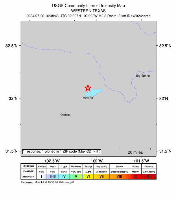
1 person reported to the USGS what they felt; the strongest reported shaking was III, weak shaking.
How well it is located
Reviewed by a seismologist.
- Location uncertainty
- About 0.4 km horizontally, 0.9 km in depth
- Magnitude uncertainty
- ±0.10
- Station coverage gap
- 50°
- Stations used
- 33
Nearest places
Distance and direction from each place to the epicenter, with its forecast.
Nearby
Within 100 km, magnitude 1.5 and up: 120 in the 60 days after this one and 61 in the 30 days before it.
After
- 2.414 km SSE of Stanton, Texas · 814 days ago · 11 km deep · 36 km away
- 2.134 km WSW of Ackerly, Texas · 812 days ago · 7 km deep · 35 km away
- 1.617 km SW of McKinney Acres, Texas · 811 days ago · 8 km deep · 52 km away
- 1.914 km WSW of Westbrook, Texas · 811 days ago · 8 km deep · 92 km away
- 1.527 km SSE of Midland, Texas · 811 days ago · 5 km deep · 39 km away
- 1.914 km E of Coahoma, Texas · 811 days ago · 6 km deep · 92 km away
- 1.715 km E of Coahoma, Texas · 810 days ago · 9 km deep · 92 km away
- 1.521 km NNW of Midland, Texas · 810 days ago · 6 km deep · 11 km away
- 1.814 km SW of Westbrook, Texas · 810 days ago · 7 km deep · 92 km away
- 2.326 km W of Garden City, Texas · 808 days ago · 7 km deep · 40 km away
- 1.512 km SSW of Big Spring, Texas · 808 days ago · 8 km deep · 55 km away
- 1.520 km NNW of Midland, Texas · 807 days ago · 9 km deep · 10 km away
- 2.021 km WNW of Stanton, Texas · 806 days ago · 9 km deep · 17 km away
- 1.922 km W of Garden City, Texas · 805 days ago · 7 km deep · 45 km away
- 2.233 km ENE of McKinney Acres, Texas · 805 days ago · 8 km deep · 31 km away
- 1.620 km NE of Gardendale, Texas · 805 days ago · 7 km deep · 12 km away
- 2.521 km WNW of Stanton, Texas · 804 days ago · 7 km deep · 17 km away · felt by 1
- 1.720 km WNW of Stanton, Texas · 804 days ago · 9 km deep · 17 km away
- 2.921 km WNW of Stanton, Texas · 804 days ago · 8 km deep · 17 km away
- 2.121 km WNW of Stanton, Texas · 804 days ago · 7 km deep · 17 km away
- 1.621 km WNW of Stanton, Texas · 804 days ago · 8 km deep · 17 km away
- 1.914 km SSE of Stanton, Texas · 804 days ago · 8 km deep · 36 km away
- 1.820 km NW of Westbrook, Texas · 803 days ago · 5 km deep · 97 km away
- 2.314 km E of Coahoma, Texas · 803 days ago · 3 km deep · 91 km away
- 2.123 km WSW of Ackerly, Texas · 803 days ago · 9 km deep · 38 km away
- 2.424 km SSW of Westbrook, Texas · 802 days ago · 4 km deep · 97 km away
- 2.124 km SSW of Westbrook, Texas · 802 days ago · 8 km deep · 97 km away
- 2.522 km S of Westbrook, Texas · 802 days ago · 9 km deep · 98 km away
- 1.722 km S of Westbrook, Texas · 802 days ago · 9 km deep · 99 km away
- 3.66 km WSW of Westbrook, Texas · 802 days ago · 9 km deep · 99 km away · felt by 6
- 1.96 km WSW of Westbrook, Texas · 802 days ago · 9 km deep · 99 km away
- 2.016 km NE of Jal, New Mexico · 801 days ago · 5 km deep · 93 km away
- 1.534 km E of McKinney Acres, Texas · 801 days ago · 8 km deep · 30 km away
- 1.59 km E of Midland, Texas · 801 days ago · 7 km deep · 17 km away
- 1.623 km SSW of Westbrook, Texas · 800 days ago · 5 km deep · 96 km away
- 2.234 km WSW of Ackerly, Texas · 799 days ago · 9 km deep · 35 km away
- 2.224 km SSW of Westbrook, Texas · 798 days ago · 9 km deep · 96 km away · felt by 1
- 1.58 km SE of Gardendale, Texas · 797 days ago · 7 km deep · 25 km away
- 2.416 km NW of Stanton, Texas · 797 days ago · 6 km deep · 24 km away · felt by 1
- 2.034 km E of McKinney Acres, Texas · 797 days ago · 8 km deep · 30 km away
- 2.024 km S of Stanton, Texas · 796 days ago · 8 km deep · 38 km away
- 1.619 km N of Stanton, Texas · 796 days ago · 6 km deep · 37 km away
- 1.79 km NNW of Forsan, Texas · 796 days ago · 8 km deep · 67 km away
- 1.62 km NW of Stanton, Texas · 794 days ago · 9 km deep · 28 km away
- 2.211 km S of Forsan, Texas · 794 days ago · 2 km deep · 68 km away
- 2.227 km S of Westbrook, Texas · 793 days ago · 8 km deep · 98 km away
- 1.78 km SE of Gardendale, Texas · 793 days ago · 7 km deep · 25 km away
- 3.215 km NE of Jal, New Mexico · 793 days ago · 3 km deep · 95 km away · felt by 1
- 1.724 km S of Westbrook, Texas · 793 days ago · 1 km deep · 98 km away
- 1.520 km NNW of Stanton, Texas · 792 days ago · 7 km deep · 34 km away
- 2.76 km WSW of Westbrook, Texas · 791 days ago · 9 km deep · 100 km away · felt by 2
- 3.025 km S of Westbrook, Texas · 791 days ago · 2 km deep · 100 km away · felt by 2
- 1.86 km WSW of Westbrook, Texas · 791 days ago · 3 km deep · 100 km away
- 2.010 km S of Forsan, Texas · 790 days ago · 9 km deep · 69 km away
- 2.937 km WSW of Ackerly, Texas · 790 days ago · 8 km deep · 35 km away · felt by 1
- 2.418 km NE of Jal, New Mexico · 789 days ago · 2 km deep · 93 km away
- 1.634 km SSW of Los Ybanez, Texas · 789 days ago · 6 km deep · 38 km away
- 2.711 km S of Forsan, Texas · 789 days ago · 9 km deep · 68 km away · felt by 1
- 1.622 km NNW of Midland, Texas · 789 days ago · 9 km deep · 12 km away
- 1.537 km WSW of Ackerly, Texas · 788 days ago · 8 km deep · 35 km away
The first 60 of 120.
Before
- 1.720 km NW of Stanton, Texas · 816 days ago · 7 km deep · 23 km away
- 1.620 km NW of Stanton, Texas · 816 days ago · 7 km deep · 23 km away
- 1.935 km SSW of Los Ybanez, Texas · 816 days ago · 9 km deep · 37 km away
- 2.020 km SSW of Westbrook, Texas · 816 days ago · 4 km deep · 96 km away
- 1.814 km SSE of Stanton, Texas · 816 days ago · 9 km deep · 37 km away
- 2.125 km S of Westbrook, Texas · 817 days ago · 2 km deep · 99 km away
- 1.634 km WSW of Ackerly, Texas · 817 days ago · 9 km deep · 37 km away
- 2.11 km WNW of Midland, Texas · 817 days ago · 6 km deep · 10 km away · felt by 1
- 1.938 km WSW of Ackerly, Texas · 817 days ago · 8 km deep · 31 km away
- 2.29 km W of Forsan, Texas · 818 days ago · 10 km deep · 59 km away
- 1.611 km S of Forsan, Texas · 818 days ago · 10 km deep · 69 km away
- 2.023 km W of Garden City, Texas · 820 days ago · 8 km deep · 42 km away
- 1.520 km WNW of Stanton, Texas · 822 days ago · 8 km deep · 17 km away
- 2.014 km SSE of Stanton, Texas · 822 days ago · 8 km deep · 36 km away
- 1.610 km ENE of Stanton, Texas · 823 days ago · 9 km deep · 39 km away
- 2.023 km SSW of Westbrook, Texas · 824 days ago · 9 km deep · 97 km away
- 3.324 km SSW of Westbrook, Texas · 824 days ago · 8 km deep · 96 km away · felt by 2
- 2.04 km W of Stanton, Texas · 825 days ago · 8 km deep · 24 km away
- 1.78 km SW of Westbrook, Texas · 825 days ago · 8 km deep · 98 km away
- 2.136 km SSW of Los Ybanez, Texas · 826 days ago · 7 km deep · 38 km away
Earthquakes todayTexas earthquakesLive radar here
Sources
From the USGS Earthquake Hazards Program and its partner networks, event tx2024nemd (also filed as us7000mxem). Read Tue, Sep 29, 2026, 6:12 AM UTC.