M2.2 earthquake 24 km SSW of Westbrook, Texas
A magnitude 2.2 earthquake struck 24 km SSW of Westbrook, Texas on Tue, Jul 23, 2024, 8:12 AM CDT (13:12 UTC), 9 km (5 mi) below the surface.
A larger quake followed: M2.9 15 km NNE of Hermleigh, Texas. This one was a foreshock.
Map
Where this earthquake was located, with the others nearby. Select one for its page.
The earthquake
- Magnitude
- 2.2 (ml), micro
- Local time
- UTC
- 2024-07-23 13:12:51 UTC
- Depth
- 8.6 km (5.4 mi), shallow
- Epicenter
- 32.141° N, 101.075° W
- Region
- Texas
- Felt reports
- 1
- Tsunami flag
- No
- Status
- Reviewed by a seismologist
Did you feel it?
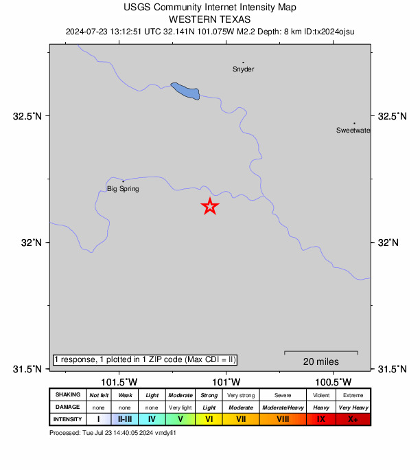
1 person reported to the USGS what they felt; the strongest reported shaking was II, weak shaking.
How well it is located
Reviewed by a seismologist.
- Location uncertainty
- About 0.7 km horizontally, 2.5 km in depth
- Magnitude uncertainty
- ±0.00
- Station coverage gap
- 76°
- Stations used
- 19
Nearest places
Distance and direction from each place to the epicenter, with its forecast.
Nearby
Within 100 km, magnitude 1.5 and up: 200 in the 60 days after this one and 0 in the 30 days before it.
After
- 2.915 km NNE of Hermleigh, Texas · 789 days ago · 4 km deep · 78 km away · felt by 13
- 1.715 km NE of Hermleigh, Texas · 789 days ago · 8 km deep · 78 km away · felt by 1
- 1.517 km NNE of Hermleigh, Texas · 789 days ago · 8 km deep · 80 km away
- 1.515 km NNE of Hermleigh, Texas · 789 days ago · 8 km deep · 78 km away · felt by 2
- 1.715 km NE of Hermleigh, Texas · 789 days ago · 7 km deep · 78 km away · felt by 1
- 2.117 km WSW of Rotan, Texas · 789 days ago · 1 km deep · 85 km away
- 1.717 km NE of Hermleigh, Texas · 789 days ago · 8 km deep · 80 km away · felt by 1
- 2.117 km NNE of Hermleigh, Texas · 789 days ago · 6 km deep · 79 km away
- 1.62 km NW of Stanton, Texas · 789 days ago · 9 km deep · 69 km away
- 1.918 km NE of Hermleigh, Texas · 789 days ago · 9 km deep · 80 km away
- 2.211 km S of Forsan, Texas · 789 days ago · 2 km deep · 32 km away
- 2.216 km NNE of Hermleigh, Texas · 788 days ago · 8 km deep · 79 km away
- 1.917 km NNE of Hermleigh, Texas · 788 days ago · 8 km deep · 79 km away
- 2.616 km NNE of Hermleigh, Texas · 788 days ago · 7 km deep · 79 km away
- 1.717 km NE of Hermleigh, Texas · 788 days ago · 8 km deep · 80 km away
- 2.017 km NNE of Hermleigh, Texas · 788 days ago · 7 km deep · 80 km away
- 2.416 km NE of Hermleigh, Texas · 788 days ago · 7 km deep · 79 km away
- 2.517 km NE of Hermleigh, Texas · 788 days ago · 7 km deep · 80 km away
- 2.227 km S of Westbrook, Texas · 788 days ago · 8 km deep · 4 km away
- 1.916 km NNE of Hermleigh, Texas · 788 days ago · 9 km deep · 79 km away
- 4.513 km NNE of Hermleigh, Texas · 788 days ago · 3 km deep · 76 km away · felt by 115
- 2.817 km NNE of Hermleigh, Texas · 788 days ago · 8 km deep · 80 km away
- 1.616 km NNE of Hermleigh, Texas · 788 days ago · 8 km deep · 79 km away · felt by 3
- 1.616 km NNE of Hermleigh, Texas · 788 days ago · 9 km deep · 79 km away
- 1.917 km NNE of Hermleigh, Texas · 788 days ago · 10 km deep · 80 km away · felt by 1
- 1.617 km NNE of Hermleigh, Texas · 788 days ago · 8 km deep · 79 km away
- 2.016 km NNE of Hermleigh, Texas · 788 days ago · 9 km deep · 79 km away
- 1.815 km NNE of Hermleigh, Texas · 788 days ago · 10 km deep · 78 km away
- 1.717 km NNE of Hermleigh, Texas · 788 days ago · 9 km deep · 80 km away
- 1.617 km NNE of Hermleigh, Texas · 788 days ago · 8 km deep · 80 km away
- 2.918 km NNE of Hermleigh, Texas · 788 days ago · 4 km deep · 81 km away · felt by 1
- 1.724 km S of Westbrook, Texas · 788 days ago · 1 km deep · 1 km away
- 2.416 km NNE of Hermleigh, Texas · 788 days ago · 4 km deep · 79 km away
- 1.815 km NNE of Hermleigh, Texas · 788 days ago · 9 km deep · 78 km away
- 2.416 km NNE of Hermleigh, Texas · 788 days ago · 1 km deep · 79 km away
- 1.816 km NNE of Hermleigh, Texas · 788 days ago · 9 km deep · 79 km away
- 1.818 km NNE of Hermleigh, Texas · 788 days ago · 9 km deep · 81 km away
- 2.217 km NE of Hermleigh, Texas · 788 days ago · 6 km deep · 80 km away
- 1.617 km NNE of Hermleigh, Texas · 788 days ago · 9 km deep · 80 km away
- 1.817 km NNE of Hermleigh, Texas · 787 days ago · 1 km deep · 80 km away
- 1.817 km NNE of Hermleigh, Texas · 787 days ago · 1 km deep · 80 km away
- 2.415 km NNE of Hermleigh, Texas · 787 days ago · 9 km deep · 78 km away
- 1.517 km WSW of Rotan, Texas · 786 days ago · 6 km deep · 84 km away
- 1.520 km NNW of Stanton, Texas · 786 days ago · 7 km deep · 74 km away
- 1.916 km NNE of Hermleigh, Texas · 786 days ago · 8 km deep · 79 km away
- 1.918 km NE of Hermleigh, Texas · 786 days ago · 8 km deep · 80 km away
- 1.518 km WSW of Rotan, Texas · 786 days ago · 8 km deep · 82 km away
- 2.76 km WSW of Westbrook, Texas · 786 days ago · 9 km deep · 21 km away · felt by 2
- 2.617 km NNE of Hermleigh, Texas · 786 days ago · 8 km deep · 80 km away · felt by 1
- 1.517 km NNE of Hermleigh, Texas · 786 days ago · 8 km deep · 80 km away
- 3.025 km S of Westbrook, Texas · 785 days ago · 2 km deep · 3 km away · felt by 2
- 2.018 km WSW of Rotan, Texas · 785 days ago · 8 km deep · 82 km away
- 2.017 km NNE of Hermleigh, Texas · 785 days ago · 8 km deep · 79 km away
- 1.86 km WSW of Westbrook, Texas · 785 days ago · 3 km deep · 20 km away
- 3.815 km NE of Hermleigh, Texas · 785 days ago · 8 km deep · 78 km away · felt by 10
- 2.017 km NE of Hermleigh, Texas · 784 days ago · 7 km deep · 80 km away
- 2.010 km S of Forsan, Texas · 784 days ago · 9 km deep · 31 km away
- 1.634 km SSW of Los Ybanez, Texas · 784 days ago · 6 km deep · 99 km away
- 2.711 km S of Forsan, Texas · 783 days ago · 9 km deep · 32 km away · felt by 1
- 1.622 km NNW of Midland, Texas · 783 days ago · 9 km deep · 100 km away
The first 60 of 200.
Earthquakes todayTexas earthquakesLive radar here
Sources
From the USGS Earthquake Hazards Program and its partner networks, event tx2024ojsu. Read Wed, Sep 23, 2026, 4:40 PM UTC.