M4.9 earthquake 275 km SE of Chiniak, Alaska
A magnitude 4.9 earthquake struck 275 km SE of Chiniak, Alaska on Wed, Feb 2, 2022, 9:24 PM AKST (06:24 UTC), 10 km (6 mi) below the surface.
Map
Where this earthquake was located, with the others nearby. Select one for its page.
The earthquake
- Magnitude
- 4.9 (mb, body-wave), light
- Magnitude from
- USGS National Earthquake Information Center
- Local time
- UTC
- 2022-02-03 06:24:56 UTC
- Depth
- 10.0 km (6.2 mi), shallow
- Epicenter
- 55.815° N, 149.196° W
- Region
- Alaska
- Strongest shaking
- I, not felt shaking
- Tsunami flag
- Yes: a large quake in an oceanic region
- Status
- Reviewed by a seismologist
Magnitude estimates
Different scales measure different things and differ by a few tenths. The USGS marks one as preferred, and it is the one this page uses.
| Mag. | Scale | Computed by | Notes |
|---|---|---|---|
| 4.9 | mb, body-wave | USGS National Earthquake Information Center | Preferred · Reviewed · ±0.027 · 420 stations |
| 4.9 | ML, local (Richter) | Alaska Earthquake Center | Preliminary |
| 4.8 | ML, local (Richter) | NOAA National Tsunami Warning Center | Reviewed · 26 stations |
Tsunami
The USGS flags a quake this large in an oceanic region. The flag does not mean a tsunami happened; the tsunami warning centers decide that, and their messages are below when they issued any.
Current tsunami warnings: tsunami.gov. Warnings in force in the US also appear on our alerts pages.
Shaking
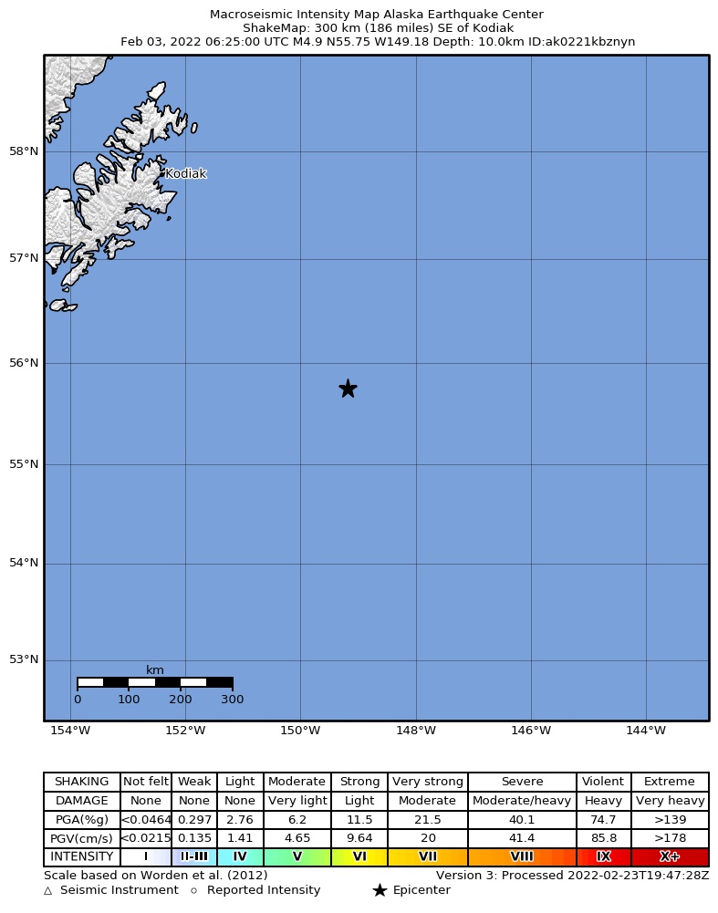
The USGS ShakeMap: shaking estimated from seismic stations and the quake’s size, on the Modified Mercalli intensity scale.
- Strongest estimated
- I, not felt shaking
- Peak ground acceleration
- 0.0% of gravity
- Peak ground velocity
- -3.4 cm/s
- Map
- Automatic
Did you feel it?
No one has reported feeling this quake to the USGS.
How well it is located
Reviewed by a seismologist.
- Location uncertainty
- About 6.6 km horizontally, 1.9 km in depth
- Magnitude uncertainty
- ±0.03
- Depth from
- Operator assigned
- Station coverage gap
- 85°
- Stations used
- 265
Nearest places
Distance and direction from each place to the epicenter, with its forecast.
Nearby
Within 100 km, magnitude 1.9 and up: 42 in the 60 days after this one and 8 in the 30 days before it.
After
- 3.5267 km SE of Chiniak, Alaska · 1702 days ago · 10 km deep · 8 km away
- 3.1278 km SE of Chiniak, Alaska · 1702 days ago · 4 km deep · 12 km away
- 2.7188 km SE of Chiniak, Alaska · 1702 days ago · 10 km deep · 99 km away
- 3.1192 km SE of Chiniak, Alaska · 1702 days ago · 10 km deep · 86 km away
- 2.7234 km SE of Chiniak, Alaska · 1700 days ago · 10 km deep · 57 km away
- 3.0222 km SE of Chiniak, Alaska · 1697 days ago · 10 km deep · 70 km away
- 2.8210 km SE of Chiniak, Alaska · 1696 days ago · 10 km deep · 65 km away
- 3.1249 km SE of Chiniak, Alaska · 1695 days ago · 10 km deep · 60 km away
- 2.9212 km SE of Chiniak, Alaska · 1694 days ago · 10 km deep · 62 km away
- 3.4243 km SE of Chiniak, Alaska · 1694 days ago · 10 km deep · 65 km away
- 3.3227 km SE of Chiniak, Alaska · 1691 days ago · 10 km deep · 71 km away
- 2.8219 km SE of Chiniak, Alaska · 1691 days ago · 10 km deep · 75 km away
- 2.8255 km SE of Chiniak, Alaska · 1689 days ago · 10 km deep · 26 km away
- 4.3224 km SE of Chiniak, Alaska · 1689 days ago · 10 km deep · 51 km away
- 3.0205 km SE of Chiniak, Alaska · 1689 days ago · 10 km deep · 70 km away
- 2.9257 km ESE of Chiniak, Alaska · 1687 days ago · 10 km deep · 78 km away
- 3.1228 km SE of Chiniak, Alaska · 1686 days ago · 10 km deep · 49 km away
- 2.6234 km ESE of Chiniak, Alaska · 1685 days ago · 10 km deep · 97 km away
- 3.1240 km SE of Chiniak, Alaska · 1684 days ago · 10 km deep · 48 km away
- 4.3241 km SE of Chiniak, Alaska · 1684 days ago · 10 km deep · 47 km away
- 2.7238 km SE of Chiniak, Alaska · 1684 days ago · 10 km deep · 43 km away
- 4.0240 km SE of Chiniak, Alaska · 1684 days ago · 10 km deep · 44 km away
- 4.2235 km SE of Chiniak, Alaska · 1684 days ago · 10 km deep · 47 km away
- 3.0Gulf of Alaska · 1684 days ago · 10 km deep · 38 km away
- 2.9253 km SE of Chiniak, Alaska · 1684 days ago · 10 km deep · 27 km away
- 2.7231 km SE of Chiniak, Alaska · 1683 days ago · 10 km deep · 47 km away
- 3.0234 km SE of Chiniak, Alaska · 1682 days ago · 10 km deep · 48 km away
- 2.8220 km ESE of Chiniak, Alaska · 1682 days ago · 10 km deep · 84 km away
- 4.4273 km SE of Chiniak, Alaska · 1676 days ago · 10 km deep · 2 km away · felt by 1
- 3.2247 km SE of Chiniak, Alaska · 1674 days ago · 10 km deep · 37 km away
- 2.7259 km ESE of Chiniak, Alaska · 1664 days ago · 22 km deep · 97 km away
- 3.2252 km SE of Chiniak, Alaska · 1660 days ago · 22 km deep · 60 km away
- 3.7255 km SE of Chiniak, Alaska · 1658 days ago · 10 km deep · 63 km away
- 2.5Gulf of Alaska · 1654 days ago · 10 km deep · 58 km away
- 2.4198 km SE of Chiniak, Alaska · 1654 days ago · 10 km deep · 77 km away
- 2.9240 km ESE of Chiniak, Alaska · 1652 days ago · 10 km deep · 78 km away
- 3.6267 km SE of Chiniak, Alaska · 1652 days ago · 10 km deep · 48 km away
- 3.2261 km SE of Chiniak, Alaska · 1651 days ago · 10 km deep · 56 km away
- 2.8186 km SE of Chiniak, Alaska · 1648 days ago · 5 km deep · 90 km away
- 2.8222 km SE of Chiniak, Alaska · 1647 days ago · 10 km deep · 59 km away
- 2.3217 km ESE of Chiniak, Alaska · 1647 days ago · 11 km deep · 96 km away
- 2.7199 km SE of Chiniak, Alaska · 1642 days ago · 10 km deep · 82 km away
Before
- 2.8228 km SE of Chiniak, Alaska · 1704 days ago · 10 km deep · 57 km away
- 2.9198 km SE of Chiniak, Alaska · 1705 days ago · 10 km deep · 80 km away
- 3.1242 km SE of Chiniak, Alaska · 1715 days ago · 10 km deep · 47 km away
- 3.9265 km SE of Chiniak, Alaska · 1717 days ago · 10 km deep · 61 km away
- 3.2249 km ESE of Chiniak, Alaska · 1717 days ago · 10 km deep · 92 km away
- 3.2244 km ESE of Chiniak, Alaska · 1718 days ago · 10 km deep · 77 km away
- 3.9222 km SE of Chiniak, Alaska · 1728 days ago · 10 km deep · 73 km away
- 3.0231 km SE of Chiniak, Alaska · 1729 days ago · 10 km deep · 68 km away
Earthquakes todayAlaska earthquakesLive radar here
Sources
From the USGS Earthquake Hazards Program and its partner networks, event us7000ghjy (also filed as at00r6pttm, ak0221kbznyn). Read Fri, Oct 2, 2026, 3:27 AM UTC.