M4.4 earthquake 60 km SSE of Cantwell, Alaska
A magnitude 4.4 earthquake struck 60 km SSE of Cantwell, Alaska on Thu, Oct 21, 2021, 10:44 AM AKDT (18:44 UTC), 72 km (45 mi) below the surface.
Map
Where this earthquake was located, with the others nearby. Select one for its page.
The earthquake
- Magnitude
- 4.4 (ml), light
- Local time
- UTC
- 2021-10-21 18:44:34 UTC
- Depth
- 72.4 km (45.0 mi), intermediate-depth
- Epicenter
- 62.928° N, 148.325° W
- Region
- Alaska
- Felt reports
- 43
- Strongest shaking
- III, weak shaking
- PAGER alert
- Green
- Tsunami flag
- No
- Status
- Reviewed by a seismologist
Shaking
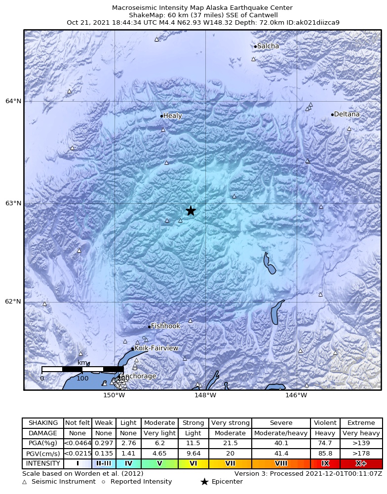
The USGS ShakeMap: shaking estimated from seismic stations and the quake’s size, on the Modified Mercalli intensity scale.
- Strongest estimated
- III, weak shaking
- Peak ground acceleration
- 0.6% of gravity
- Peak ground velocity
- -1.5 cm/s
- Map
- Automatic
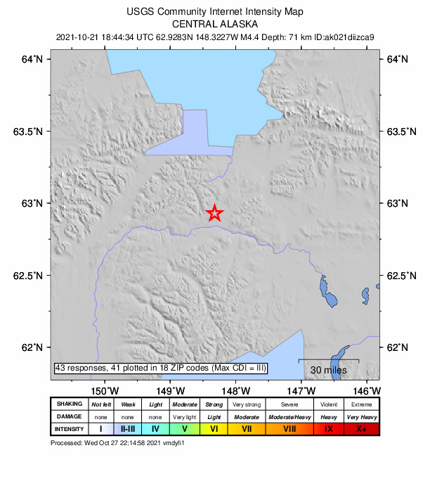
Did you feel it?
43 people reported to the USGS what they felt; the strongest reported shaking was III, weak shaking.
Estimated impact
The USGS PAGER system estimates deaths and economic losses from the shaking and the population and buildings exposed to it.
- Alert level
- Green: little or no damage or loss of life expected
| Range | Chance |
|---|---|
| Under 1 | 69% |
| 1 to 10 | 29% |
| 10 to 100 | 2% |
| 100 to 1,000 | Under 1% |
| 1,000 to 10,000 | Under 1% |
| 10,000 to 100,000 | Under 1% |
| 100,000 to 10,000,000 | Under 1% |
| Range, million USD | Chance |
|---|---|
| Under 1 | 65% |
| 1 to 10 | 30% |
| 10 to 100 | 4% |
| 100 to 1,000 | Under 1% |
| 1,000 to 10,000 | Under 1% |
| 10,000 to 100,000 | Under 1% |
| 100,000 to 10,000,000 | Under 1% |
Fault motion and ground failure
How the rock slipped, from the moment tensor, and the USGS estimate of landslides and liquefaction.
- Faulting
- Oblique normal
- Moment magnitude
- 4.3 Mwr
- Nodal plane 1
- Strike 62°, dip 65°, rake -45°
- Nodal plane 2
- Strike 174°, dip 50°, rake -147°
How well it is located
Reviewed by a seismologist.
- Stations used
- 267
Nearest places
Distance and direction from each place to the epicenter, with its forecast.
Nearby
Within 100 km, magnitude 1.5 and up: 103 in the 60 days after this one and 69 in the 30 days before it.
After
- 1.945 km SW of Cantwell, Alaska · 1801 days ago · 87 km deep · 61 km away
- 1.656 km SW of Cantwell, Alaska · 1801 days ago · 81 km deep · 72 km away
- 1.977 km SW of Fort Greely, Alaska · 1800 days ago · 0 km deep · 100 km away
- 1.741 km N of Chickaloon, Alaska · 1800 days ago · 15 km deep · 85 km away
- 1.653 km E of Chase, Alaska · 1800 days ago · 55 km deep · 63 km away
- 1.965 km S of Cantwell, Alaska · 1799 days ago · 65 km deep · 38 km away
- 1.761 km SSE of Cantwell, Alaska · 1798 days ago · 12 km deep · 3 km away
- 1.675 km ESE of Denali Park, Alaska · 1798 days ago · 5 km deep · 85 km away
- 2.169 km E of Denali Park, Alaska · 1796 days ago · 74 km deep · 88 km away
- 1.750 km ENE of Chase, Alaska · 1794 days ago · 54 km deep · 58 km away
- 1.629 km SSW of Cantwell, Alaska · 1794 days ago · 74 km deep · 46 km away
- 1.630 km N of Chickaloon, Alaska · 1794 days ago · 27 km deep · 95 km away
- 1.750 km WSW of Cantwell, Alaska · 1792 days ago · 88 km deep · 87 km away
- 2.376 km E of Denali Park, Alaska · 1792 days ago · 80 km deep · 91 km away
- 1.669 km SE of Cantwell, Alaska · 1792 days ago · 65 km deep · 10 km away
- 1.832 km NNW of Glacier View, Alaska · 1791 days ago · 29 km deep · 97 km away
- 2.4Central Alaska · 1791 days ago · 17 km deep · 65 km away
- 2.274 km N of Chickaloon, Alaska · 1791 days ago · 39 km deep · 52 km away
- 1.688 km SW of Delta Junction, Alaska · 1791 days ago · 0 km deep · 91 km away
- 1.658 km NNE of Chase, Alaska · 1790 days ago · 91 km deep · 75 km away
- 1.738 km W of Cantwell, Alaska · 1790 days ago · 95 km deep · 84 km away
- 2.522 km ENE of Chase, Alaska · 1789 days ago · 55 km deep · 83 km away
- 1.623 km ENE of Chase, Alaska · 1789 days ago · 59 km deep · 82 km away
- 1.535 km NNW of Sutton-Alpine, Alaska · 1788 days ago · 28 km deep · 97 km away
- 1.959 km SW of Cantwell, Alaska · 1788 days ago · 76 km deep · 76 km away
- 2.860 km SSE of Cantwell, Alaska · 1786 days ago · 9 km deep · 3 km away · felt by 1
- 2.043 km WSW of Cantwell, Alaska · 1786 days ago · 105 km deep · 86 km away · felt by 1
- 1.561 km ESE of Denali Park, Alaska · 1786 days ago · 5 km deep · 76 km away
- 1.742 km NE of Chase, Alaska · 1785 days ago · 64 km deep · 65 km away
- 1.742 km NE of Chase, Alaska · 1785 days ago · 64 km deep · 65 km away
- 2.921 km NNW of Cantwell, Alaska · 1784 days ago · 6 km deep · 82 km away · felt by 2
- 1.870 km ENE of Chase, Alaska · 1784 days ago · 51 km deep · 36 km away
- 1.932 km E of Chase, Alaska · 1783 days ago · 50 km deep · 83 km away
- 2.017 km NE of Susitna North, Alaska · 1783 days ago · 47 km deep · 98 km away
- 1.540 km SE of Cantwell, Alaska · 1783 days ago · 75 km deep · 28 km away
- 1.569 km ENE of Chase, Alaska · 1783 days ago · 9 km deep · 36 km away
- 1.570 km ENE of Chase, Alaska · 1781 days ago · 9 km deep · 35 km away
- 2.680 km NW of Lake Louise, Alaska · 1781 days ago · 5 km deep · 36 km away
- 1.646 km E of Chase, Alaska · 1781 days ago · 3 km deep · 69 km away
- 1.557 km E of Chase, Alaska · 1780 days ago · 50 km deep · 55 km away
- 2.068 km E of Cantwell, Alaska · 1780 days ago · 67 km deep · 64 km away
- 1.569 km SE of Cantwell, Alaska · 1780 days ago · 60 km deep · 11 km away
- 1.781 km SSE of Cantwell, Alaska · 1778 days ago · 48 km deep · 28 km away
- 1.730 km SSE of Cantwell, Alaska · 1778 days ago · 70 km deep · 30 km away
- 1.569 km ENE of Chase, Alaska · 1777 days ago · 9 km deep · 36 km away
- 1.674 km ESE of Denali Park, Alaska · 1775 days ago · 5 km deep · 84 km away
- 1.717 km ENE of Talkeetna, Alaska · 1774 days ago · 59 km deep · 97 km away
- 1.642 km ENE of Susitna North, Alaska · 1774 days ago · 3 km deep · 77 km away
- 2.472 km ESE of Denali Park, Alaska · 1773 days ago · 3 km deep · 80 km away
- 2.136 km W of Cantwell, Alaska · 1773 days ago · 101 km deep · 83 km away
- 1.532 km SSE of Cantwell, Alaska · 1773 days ago · 5 km deep · 32 km away
- 1.639 km NNE of Chase, Alaska · 1772 days ago · 69 km deep · 79 km away
- 1.632 km NW of Eureka Roadhouse, Alaska · 1772 days ago · 18 km deep · 93 km away
- 1.666 km ENE of Cantwell, Alaska · 1771 days ago · 8 km deep · 74 km away
- 2.256 km N of Chase, Alaska · 1770 days ago · 87 km deep · 92 km away
- 1.550 km NE of Chase, Alaska · 1770 days ago · 71 km deep · 61 km away
- 2.347 km SSE of Cantwell, Alaska · 1770 days ago · 71 km deep · 22 km away
- 1.758 km ENE of Susitna North, Alaska · 1770 days ago · 41 km deep · 66 km away
- 1.842 km NNW of Glacier View, Alaska · 1769 days ago · 35 km deep · 87 km away
- 2.248 km NE of Chase, Alaska · 1769 days ago · 5 km deep · 58 km away
The first 60 of 103.
Before
- 1.519 km ENE of Susitna North, Alaska · 1802 days ago · 43 km deep · 99 km away
- 1.971 km SSE of Cantwell, Alaska · 1802 days ago · 63 km deep · 15 km away
- 1.861 km NE of Chase, Alaska · 1803 days ago · 52 km deep · 45 km away
- 1.962 km NE of Chase, Alaska · 1803 days ago · 63 km deep · 43 km away
- 1.645 km E of Denali Park, Alaska · 1803 days ago · 81 km deep · 88 km away
- 1.671 km SSE of Cantwell, Alaska · 1803 days ago · 62 km deep · 11 km away
- 1.770 km S of Cantwell, Alaska · 1804 days ago · 6 km deep · 28 km away
- 3.935 km NE of Chase, Alaska · 1804 days ago · 74 km deep · 71 km away · felt by 33
- 1.927 km W of Cantwell, Alaska · 1805 days ago · 90 km deep · 75 km away
- 1.574 km ESE of Denali Park, Alaska · 1805 days ago · 1 km deep · 83 km away
- 2.017 km NE of Susitna North, Alaska · 1805 days ago · 46 km deep · 99 km away
- 1.5Central Alaska · 1805 days ago · 10 km deep · 2 km away
- 1.5Central Alaska · 1808 days ago · 92 km deep · 84 km away
- 1.661 km SSE of Cantwell, Alaska · 1809 days ago · 14 km deep · 4 km away
- 1.543 km NNE of Chase, Alaska · 1812 days ago · 75 km deep · 69 km away
- 1.530 km NNW of Chickaloon, Alaska · 1812 days ago · 39 km deep · 98 km away
- 1.872 km NW of Eureka Roadhouse, Alaska · 1813 days ago · 37 km deep · 56 km away
- 1.661 km WSW of Cantwell, Alaska · 1813 days ago · 98 km deep · 99 km away
- 1.6Central Alaska · 1814 days ago · 1 km deep · 91 km away
- 1.864 km SE of Cantwell, Alaska · 1814 days ago · 69 km deep · 16 km away
Earthquakes todayAlaska earthquakesLive radar here
Sources
From the USGS Earthquake Hazards Program and its partner networks, event ak021diizca9 (also filed as us6000fwhz). Read Sun, Sep 27, 2026, 6:11 PM UTC.