M6.5 earthquake Monte Cristo Range, NV Earthquake
A magnitude 6.5 earthquake struck in Monte Cristo Range, NV Earthquake on Fri, May 15, 2020, 4:03 AM PDT (11:03 UTC), 3 km (2 mi) below the surface.
Map
Where this earthquake was located, with the others nearby. Select one for its page.
The earthquake
- Magnitude
- 6.5 (ML, local (Richter)), strong
- Magnitude from
- Nevada Seismological Laboratory
- Local time
- UTC
- 2020-05-15 11:03:27 UTC
- Depth
- 2.7 km (1.7 mi), shallow
- Epicenter
- 38.169° N, 117.850° W
- Region
- Nevada
- Felt reports
- 11,961
- Strongest shaking
- VIII, severe shaking
- PAGER alert
- Green
- Tsunami flag
- No
- Status
- Reviewed by a seismologist
Magnitude estimates
Different scales measure different things and differ by a few tenths. The USGS marks one as preferred, and it is the one this page uses.
| Mag. | Scale | Computed by | Notes |
|---|---|---|---|
| 6.5 | ML, local (Richter) | Nevada Seismological Laboratory | Preferred · Reviewed |
| 6.5 | Mww, W-phase moment | USGS National Earthquake Information Center | Reviewed · ±0.038 · 65 stations |
| 6.47 | Mw, moment | ISC-GEM global catalog | Final · ±0.1 |
| 6.8 | Mi | NOAA Pacific Tsunami Warning Center | First automatic solution · Reviewed · 26 stations |
| 6.4 | Mwb, body-wave moment | USGS National Earthquake Information Center | Moment tensor · Reviewed |
| 6.3 | Mwr, regional moment | Nevada Seismological Laboratory | Moment tensor · Reviewed |
What happened
The USGS’s account of the effects of this earthquake.
Minor damage occurred at Tonopah and U.S. Route 95 between Las Vegas and Reno was closed due to cracks.
From the USGS event page for nn00725272. U.S. Geological Survey text and figures are in the public domain.
Shaking
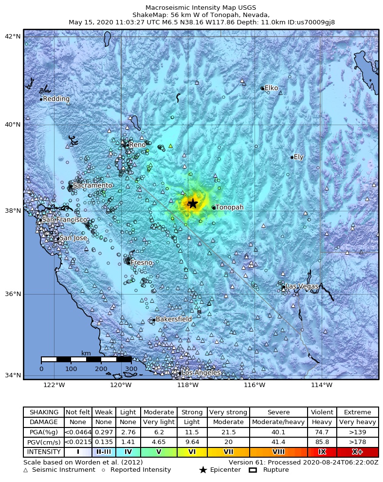
The USGS ShakeMap: shaking estimated from seismic stations and the quake’s size, on the Modified Mercalli intensity scale.
- Strongest estimated
- VIII, severe shaking
- Peak ground acceleration
- 50.4% of gravity
- Peak ground velocity
- 3.9 cm/s
- Map
- Automatic
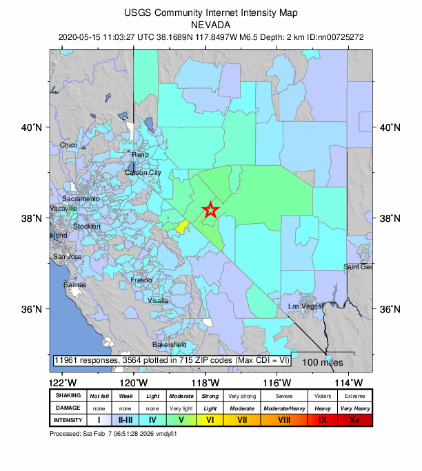
Did you feel it?
11,961 people reported to the USGS what they felt; the strongest reported shaking was VII, very strong shaking.
Estimated impact
The USGS PAGER system estimates deaths and economic losses from the shaking and the population and buildings exposed to it.
- Alert level
- Green: little or no damage or loss of life expected
| Range | Chance |
|---|---|
| Under 1 | 65% |
| 1 to 10 | 30% |
| 10 to 100 | 4% |
| 100 to 1,000 | Under 1% |
| 1,000 to 10,000 | Under 1% |
| 10,000 to 100,000 | Under 1% |
| 100,000 to 10,000,000 | Under 1% |
| Range, million USD | Chance |
|---|---|
| Under 1 | Over 99% |
| 1 to 10 | Under 1% |
| 10 to 100 | Under 1% |
| 100 to 1,000 | Under 1% |
| 1,000 to 10,000 | Under 1% |
| 10,000 to 100,000 | Under 1% |
| 100,000 to 10,000,000 | Under 1% |
Fault motion and ground failure
How the rock slipped, from the moment tensor, and the USGS estimate of landslides and liquefaction.
- Faulting
- Strike-slip
- Moment magnitude
- 6.5 Mww
- Nodal plane 1
- Strike 168°, dip 67°, rake -167°
- Nodal plane 2
- Strike 73°, dip 78°, rake -24°
- Landslide alert
- Green
- Liquefaction alert
- Yellow
Tectonic setting
Why earthquakes happen here, from the USGS tectonic summary.
The May 15, 2020 M 6.5 earthquake 56 km west f Tonopah, Nevada, occurred as the result of strike slip faulting in the shallow crust of the North America plate. Preliminary focal mechanism solutions for the event, which describe the style of faulting in an earthquake, indicate slip likely occurred on a steeply dipping fault striking either east-west (left-lateral) or north-south (right-lateral). This earthquake occurred within the Walker Lane, an active zone of seismicity roughly aligned with the California-Nevada border. Tectonically, the Walker Lane accommodates up to 25% of the North America:Pacific Plate motion, with the remainder mostly accommodated on the San Andreas fault system.
About two dozen M5+ earthquakes have occurred within 100 km of this event over the past 50 years, mostly to the west and south. Two M6+ events have occurred over the same region in the past century – a M 6.5 earthquake 40 km to the northwest in January 1934, and a M 6.8 event 50 km to the north in December 1932. Both of these earthquakes caused severe local shaking (MMI VIII); the 1932 earthquake is documented to have caused damage in the sparsely populated surrounding region. As of 12:00 UTC, 6 M4+ aftershocks have occurred since the M 6.5 earthquake, extending over a region about 30 km to the west of the mainshock.
From the USGS event page for nn00725272. U.S. Geological Survey text and figures are in the public domain.
How well it is located
Reviewed by a seismologist.
- Station coverage gap
- 56°
- Stations used
- 27
Nearest places
Distance and direction from each place to the epicenter, with its forecast.
Nearby
Within 100 km, magnitude 3.5 and up: 127 in the 60 days after this one and 5 in the 30 days before it.
After
- 4.129 km SSE of Mina, Nevada · 2331 days ago · 11 km deep · 13 km away · felt by 97
- 3.537 km SE of Mina, Nevada · 2331 days ago · 18 km deep · 7 km away
- 4.028 km SE of Mina, Nevada · 2331 days ago · 7 km deep · 5 km away · felt by 32
- 3.832 km SSE of Mina, Nevada · 2331 days ago · 5 km deep · 6 km away · felt by 29
- 4.928 km SSE of Mina, Nevada · 2331 days ago · 4 km deep · 10 km away · felt by 234
- 3.626 km SSE of Mina, Nevada · 2331 days ago · 5 km deep · 11 km away
- 5.131 km SE of Mina, Nevada · 2331 days ago · 7 km deep · 2 km away · felt by 170
- 4.030 km SSE of Mina, Nevada · 2331 days ago · 6 km deep · 13 km away · felt by 13
- 4.829 km SSE of Mina, Nevada · 2331 days ago · 6 km deep · 12 km away · felt by 18
- 3.531 km SE of Mina, Nevada · 2331 days ago · 10 km deep · 3 km away
- 4.536 km SE of Mina, Nevada · 2331 days ago · 6 km deep · 3 km away · felt by 41
- 3.532 km SE of Mina, Nevada · 2331 days ago · 18 km deep · 2 km away · felt by 4
- 4.337 km SE of Mina, Nevada · 2331 days ago · 8 km deep · 5 km away · felt by 7
- 3.834 km ESE of Mina, Nevada · 2331 days ago · 9 km deep · 9 km away · felt by 6
- 3.930 km SSE of Mina, Nevada · 2331 days ago · 6 km deep · 9 km away · felt by 4
- 4.228 km SSE of Mina, Nevada · 2331 days ago · 7 km deep · 8 km away · felt by 5
- 3.931 km SE of Mina, Nevada · 2331 days ago · 3 km deep · 4 km away
- 4.836 km SE of Mina, Nevada · 2331 days ago · 8 km deep · 4 km away · felt by 14
- 3.935 km SE of Mina, Nevada · 2331 days ago · 7 km deep · 4 km away · felt by 5
- 3.533 km SE of Mina, Nevada · 2331 days ago · 5 km deep · 1 km away
- 3.734 km SE of Mina, Nevada · 2331 days ago · 8 km deep · 2 km away · felt by 1
- 3.529 km SSE of Mina, Nevada · 2331 days ago · 11 km deep · 15 km away · felt by 1
- 3.727 km SSE of Mina, Nevada · 2331 days ago · 5 km deep · 9 km away
- 4.734 km SE of Mina, Nevada · 2331 days ago · 6 km deep · 2 km away · felt by 15
- 4.232 km SE of Mina, Nevada · 2331 days ago · 6 km deep · 2 km away
- 3.832 km SE of Mina, Nevada · 2331 days ago · 4 km deep · 1 km away
- 3.538 km ESE of Mina, Nevada · 2331 days ago · 6 km deep · 12 km away · felt by 1
- 3.934 km SE of Mina, Nevada · 2330 days ago · 0 km deep · 1 km away
- 3.628 km SSE of Mina, Nevada · 2330 days ago · 7 km deep · 11 km away
- 3.526 km SSE of Mina, Nevada · 2330 days ago · 6 km deep · 9 km away
- 4.236 km SE of Mina, Nevada · 2330 days ago · 6 km deep · 4 km away · felt by 5
- 4.327 km SSE of Mina, Nevada · 2330 days ago · 5 km deep · 14 km away · felt by 3
- 3.840 km SE of Mina, Nevada · 2330 days ago · 2 km deep · 11 km away
- 4.333 km SE of Mina, Nevada · 2330 days ago · 11 km deep · 1 km away · felt by 11
- 3.528 km SE of Mina, Nevada · 2330 days ago · 19 km deep · 6 km away
- 3.526 km SSE of Mina, Nevada · 2330 days ago · 7 km deep · 14 km away
- 4.631 km SSE of Mina, Nevada · 2330 days ago · 5 km deep · 12 km away · felt by 9
- 3.832 km SE of Mina, Nevada · 2330 days ago · 9 km deep · 1 km away
- 3.732 km SE of Mina, Nevada · 2330 days ago · 1 km deep · 1 km away
- 3.8Nevada · 2330 days ago · 12 km deep · 7 km away
- 3.733 km NE of Benton, California · 2330 days ago · 6 km deep · 36 km away · felt by 1
- 3.639 km ESE of Mina, Nevada · 2330 days ago · 11 km deep · 13 km away
- 3.538 km ESE of Mina, Nevada · 2330 days ago · 5 km deep · 11 km away · felt by 2
- 3.538 km SE of Mina, Nevada · 2330 days ago · 7 km deep · 9 km away
- 3.539 km SE of Mina, Nevada · 2330 days ago · 7 km deep · 9 km away
- 3.928 km SE of Mina, Nevada · 2330 days ago · 7 km deep · 5 km away · felt by 1
- 4.638 km ESE of Mina, Nevada · 2330 days ago · 17 km deep · 11 km away · felt by 17
- 3.839 km SE of Mina, Nevada · 2330 days ago · 11 km deep · 10 km away
- 3.627 km SSE of Mina, Nevada · 2330 days ago · 7 km deep · 15 km away
- 3.835 km ESE of Mina, Nevada · 2329 days ago · 6 km deep · 9 km away
- 3.727 km SSE of Mina, Nevada · 2329 days ago · 5 km deep · 8 km away · felt by 2
- 4.428 km SSE of Mina, Nevada · 2329 days ago · 5 km deep · 16 km away · felt by 1
- 3.533 km SE of Mina, Nevada · 2329 days ago · 6 km deep · 1 km away
- 3.539 km SE of Mina, Nevada · 2329 days ago · 7 km deep · 9 km away
- 4.334 km SE of Mina, Nevada · 2329 days ago · 7 km deep · 1 km away · felt by 3
- 3.735 km SE of Mina, Nevada · 2329 days ago · 12 km deep · 7 km away
- 4.529 km SSE of Mina, Nevada · 2329 days ago · 10 km deep · 9 km away · felt by 10
- 3.928 km SSE of Mina, Nevada · 2329 days ago · 11 km deep · 10 km away
- 3.539 km SE of Mina, Nevada · 2329 days ago · 8 km deep · 10 km away · felt by 1
- 3.728 km SSE of Mina, Nevada · 2329 days ago · 6 km deep · 13 km away
The first 60 of 127.
Before
- 3.734 km NW of Benton, California · 2338 days ago · 6 km deep · 79 km away
- 4.029km SE of Bodie, CA · 2355 days ago · 7 km deep · 80 km away · felt by 24
- 3.730km SE of Bodie, CA · 2359 days ago · 8 km deep · 78 km away · felt by 6
- 4.029km SE of Bodie, CA · 2360 days ago · 4 km deep · 80 km away · felt by 6
- 3.929km SE of Bodie, CA · 2360 days ago · 8 km deep · 80 km away · felt by 6
Earthquakes todayNevada earthquakesLive radar here
Sources
From the USGS Earthquake Hazards Program and its partner networks, event nn00725272 (also filed as us70009gj8, pt20136000, iscgem618259420). Read Fri, Oct 2, 2026, 6:49 AM UTC.