M3.6 earthquake 26 km SSE of Mina, Nevada
A magnitude 3.6 earthquake struck 26 km SSE of Mina, Nevada on Fri, May 15, 2020, 4:25 AM PDT (11:25 UTC), 5 km (3 mi) below the surface.
A larger quake followed: M5.1 32 km ESE of Mina, Nevada. This one was a foreshock.
Map
Where this earthquake was located, with the others nearby. Select one for its page.
The earthquake
- Magnitude
- 3.6 (ML, local (Richter)), minor
- Magnitude from
- USGS National Earthquake Information Center
- Local time
- UTC
- 2020-05-15 11:25:42 UTC
- Depth
- 5.0 km (3.1 mi), shallow
- Epicenter
- 38.174° N, 117.974° W
- Region
- Nevada
- Strongest shaking
- IV, light shaking
- Tsunami flag
- No
- Status
- Reviewed by a seismologist
Shaking
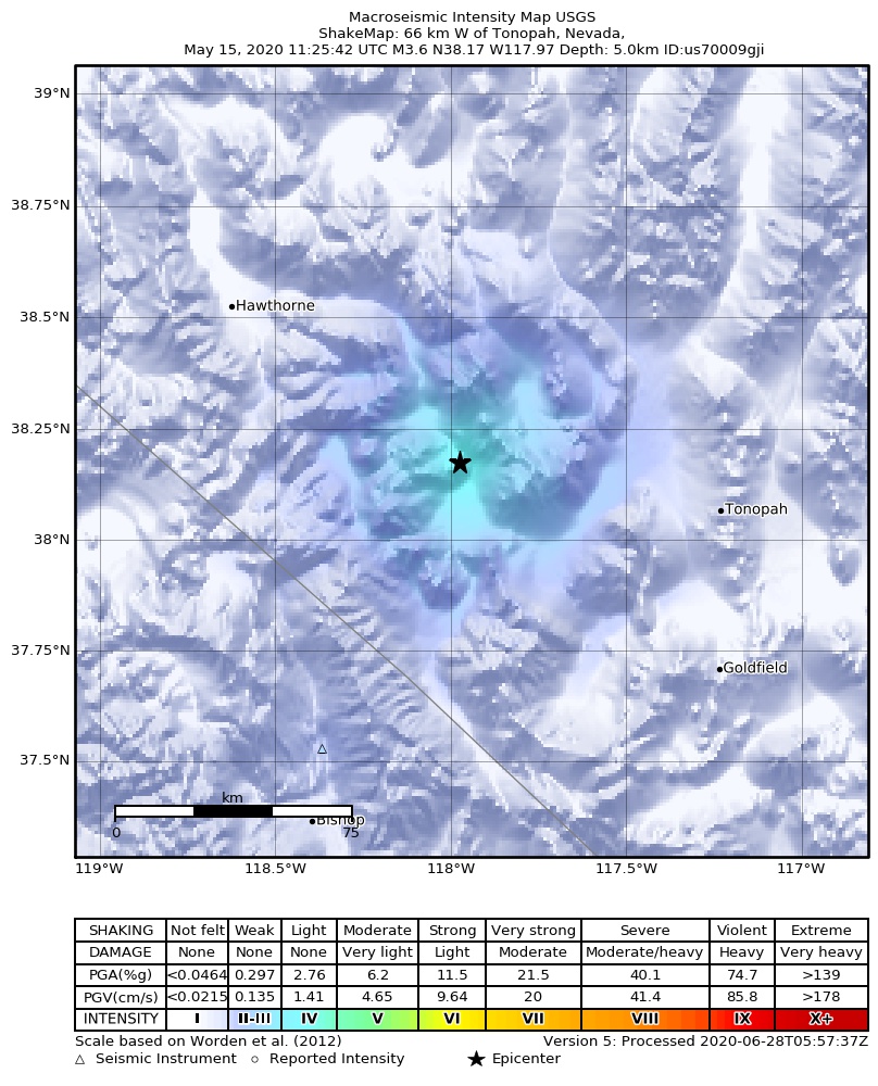
The USGS ShakeMap: shaking estimated from seismic stations and the quake’s size, on the Modified Mercalli intensity scale.
- Strongest estimated
- IV, light shaking
- Peak ground acceleration
- 3.6% of gravity
- Peak ground velocity
- 0.3 cm/s
- Map
- Automatic
Did you feel it?
No one has reported feeling this quake to the USGS.
How well it is located
Reviewed by a seismologist.
- Location uncertainty
- About 1.3 km horizontally, 1.9 km in depth
- Magnitude uncertainty
- ±0.15
- Depth from
- Operator assigned
- Station coverage gap
- 49°
- Stations used
- 38
Nearest places
Distance and direction from each place to the epicenter, with its forecast.
Nearby
Within 100 km, magnitude 1.5 and up: at least 201 in the 60 days after this one and at least 200 in the 30 days before it.
After
- 5.131 km SE of Mina, Nevada · 2331 days ago · 7 km deep · 9 km away · felt by 170
- 4.030 km SSE of Mina, Nevada · 2331 days ago · 6 km deep · 5 km away · felt by 13
- 3.029 km SSE of Mina, Nevada · 2331 days ago · 6 km deep · 3 km away
- 3.030 km SSE of Mina, Nevada · 2331 days ago · 0 km deep · 6 km away
- 2.839 km SE of Mina, Nevada · 2331 days ago · 0 km deep · 19 km away
- 3.229 km SSE of Mina, Nevada · 2331 days ago · 10 km deep · 6 km away · felt by 4
- 3.039 km SE of Mina, Nevada · 2331 days ago · 0 km deep · 20 km away
- 3.431 km SSE of Mina, Nevada · 2331 days ago · 7 km deep · 5 km away · felt by 5
- 2.536 km SE of Mina, Nevada · 2331 days ago · 18 km deep · 17 km away
- 4.829 km SSE of Mina, Nevada · 2331 days ago · 6 km deep · 3 km away · felt by 18
- 3.430 km SE of Mina, Nevada · 2331 days ago · 3 km deep · 6 km away · felt by 2
- 3.531 km SE of Mina, Nevada · 2331 days ago · 10 km deep · 7 km away
- 4.536 km SE of Mina, Nevada · 2331 days ago · 6 km deep · 14 km away · felt by 41
- 2.832 km SE of Mina, Nevada · 2331 days ago · 9 km deep · 9 km away
- 2.931 km SE of Mina, Nevada · 2331 days ago · 8 km deep · 7 km away
- 2.730 km SSE of Mina, Nevada · 2331 days ago · 8 km deep · 4 km away
- 2.631 km SE of Mina, Nevada · 2331 days ago · 4 km deep · 16 km away
- 2.930 km SSE of Mina, Nevada · 2331 days ago · 0 km deep · 6 km away
- 2.531 km SE of Mina, Nevada · 2331 days ago · 11 km deep · 7 km away
- 3.532 km SE of Mina, Nevada · 2331 days ago · 18 km deep · 9 km away · felt by 4
- 3.228 km SE of Mina, Nevada · 2331 days ago · 6 km deep · 7 km away · felt by 1
- 2.830 km SSE of Mina, Nevada · 2331 days ago · 7 km deep · 4 km away
- 2.629 km SSE of Mina, Nevada · 2331 days ago · 0 km deep · 5 km away
- 2.434 km SE of Mina, Nevada · 2331 days ago · 0 km deep · 11 km away
- 2.324 km SE of Mina, Nevada · 2331 days ago · 0 km deep · 10 km away
- 3.132 km SE of Mina, Nevada · 2331 days ago · 18 km deep · 9 km away · felt by 2
- 3.029 km SE of Mina, Nevada · 2331 days ago · 10 km deep · 5 km away · felt by 1
- 2.538 km SE of Mina, Nevada · 2331 days ago · 3 km deep · 17 km away
- 2.733 km SE of Mina, Nevada · 2331 days ago · 1 km deep · 14 km away
- 2.826 km SE of Mina, Nevada · 2331 days ago · 18 km deep · 9 km away
- 2.831 km SSE of Mina, Nevada · 2331 days ago · 17 km deep · 6 km away
- 2.926 km SSE of Mina, Nevada · 2331 days ago · 12 km deep · 3 km away
- 2.133 km SE of Mina, Nevada · 2331 days ago · 11 km deep · 8 km away
- 3.031 km SE of Mina, Nevada · 2331 days ago · 18 km deep · 10 km away
- 3.335 km SE of Mina, Nevada · 2331 days ago · 6 km deep · 17 km away · felt by 1
- 3.136 km SE of Mina, Nevada · 2331 days ago · 9 km deep · 15 km away · felt by 1
- 1.929 km SSE of Mina, Nevada · 2331 days ago · 4 km deep · 3 km away
- 3.327 km SSE of Mina, Nevada · 2331 days ago · 5 km deep · 6 km away · felt by 2
- 3.039 km SE of Mina, Nevada · 2331 days ago · 0 km deep · 20 km away · felt by 1
- 2.934 km SE of Mina, Nevada · 2331 days ago · 0 km deep · 11 km away
- 4.337 km SE of Mina, Nevada · 2331 days ago · 8 km deep · 16 km away · felt by 7
- 2.733 km SE of Mina, Nevada · 2331 days ago · 4 km deep · 10 km away
- 2.430 km SE of Mina, Nevada · 2331 days ago · 10 km deep · 8 km away
- 2.532 km SSE of Mina, Nevada · 2331 days ago · 6 km deep · 6 km away
- 2.626 km S of Mina, Nevada · 2331 days ago · 16 km deep · 7 km away
- 2.632 km SE of Mina, Nevada · 2331 days ago · 8 km deep · 8 km away
- 3.029 km SE of Mina, Nevada · 2331 days ago · 9 km deep · 5 km away
- 2.830 km SSE of Mina, Nevada · 2331 days ago · 9 km deep · 4 km away
- 3.333 km SE of Mina, Nevada · 2331 days ago · 5 km deep · 10 km away
- 2.429 km SSE of Mina, Nevada · 2331 days ago · 13 km deep · 3 km away
- 2.534 km SE of Mina, Nevada · 2331 days ago · 9 km deep · 16 km away
- 3.326 km SSE of Mina, Nevada · 2331 days ago · 9 km deep · 2 km away · felt by 5
- 3.232 km SE of Mina, Nevada · 2331 days ago · 4 km deep · 10 km away
- 2.737 km SE of Mina, Nevada · 2331 days ago · 0 km deep · 18 km away
- 3.834 km ESE of Mina, Nevada · 2331 days ago · 9 km deep · 18 km away · felt by 6
- 3.930 km SSE of Mina, Nevada · 2331 days ago · 6 km deep · 4 km away · felt by 4
- 2.826 km SSE of Mina, Nevada · 2331 days ago · 18 km deep · 3 km away
- 2.234 km ESE of Mina, Nevada · 2331 days ago · 14 km deep · 24 km away
- 2.631 km SSE of Mina, Nevada · 2331 days ago · 5 km deep · 5 km away
- 3.439 km SE of Mina, Nevada · 2331 days ago · 7 km deep · 21 km away · felt by 1
The first 60 of at least 201.
Before
- 2.929 km SE of Mina, Nevada · 2331 days ago · 19 km deep · 9 km away
- 3.426 km SSE of Mina, Nevada · 2331 days ago · 16 km deep · 5 km away · felt by 5
- 4.928 km SSE of Mina, Nevada · 2331 days ago · 4 km deep · 2 km away · felt by 234
- 3.832 km SSE of Mina, Nevada · 2331 days ago · 5 km deep · 6 km away · felt by 29
- 4.028 km SE of Mina, Nevada · 2331 days ago · 7 km deep · 9 km away · felt by 32
- 3.537 km SE of Mina, Nevada · 2331 days ago · 18 km deep · 18 km away
- 4.129 km SSE of Mina, Nevada · 2331 days ago · 11 km deep · 4 km away · felt by 97
- 6.5Monte Cristo Range, NV Earthquake · 2331 days ago · 3 km deep · 11 km away · felt by 11,961
- 2.128km SE of Bodie, CA · 2332 days ago · 5 km deep · 74 km away
- 2.129km SE of Bodie, CA · 2333 days ago · 5 km deep · 70 km away
- 2.529km SE of Bodie, CA · 2333 days ago · 7 km deep · 70 km away
- 2.029km SE of Bodie, CA · 2333 days ago · 3 km deep · 71 km away
- 1.827km SE of Bodie, CA · 2334 days ago · 6 km deep · 74 km away
- 3.510km NNW of Deep Springs, CA · 2334 days ago · 13 km deep · 81 km away · felt by 22
- 2.030km SE of Bodie, CA · 2334 days ago · 5 km deep · 67 km away
- 1.929km SE of Bodie, CA · 2334 days ago · 5 km deep · 71 km away
- 2.328km SE of Bodie, CA · 2334 days ago · 5 km deep · 74 km away
- 1.628km SE of Bodie, CA · 2334 days ago · 6 km deep · 74 km away
- 1.928km SE of Bodie, CA · 2334 days ago · 9 km deep · 73 km away
- 1.629km SE of Bodie, CA · 2335 days ago · 5 km deep · 71 km away
Earthquakes todayNevada earthquakesLive radar here
Sources
From the USGS Earthquake Hazards Program and its partner networks, event us70009gji. Read Fri, Oct 2, 2026, 7:10 PM UTC.