M2.3 earthquake 26 km WSW of Hawthorne, Nevada
A magnitude 2.3 earthquake struck 26 km WSW of Hawthorne, Nevada on Mon, Mar 30, 2020, 1:18 AM PDT (08:18 UTC), 11 km (7 mi) below the surface.
A larger quake followed: M6.5 Monte Cristo Range, NV Earthquake. This one was a foreshock.
Map
Where this earthquake was located, with the others nearby. Select one for its page.
The earthquake
- Magnitude
- 2.3 (ML, local (Richter)), micro
- Magnitude from
- Nevada Seismological Laboratory
- Local time
- UTC
- 2020-03-30 08:18:26 UTC
- Depth
- 10.7 km (6.6 mi), shallow
- Epicenter
- 38.400° N, 118.881° W
- Region
- Nevada
- Felt reports
- 1
- Tsunami flag
- No
- Status
- Reviewed by a seismologist
Magnitude estimates
Different scales measure different things and differ by a few tenths. The USGS marks one as preferred, and it is the one this page uses.
| Mag. | Scale | Computed by | Notes |
|---|---|---|---|
| 2.3 | ML, local (Richter) | Nevada Seismological Laboratory | Preferred · Reviewed · ±0.36 · 9 stations |
| 2.3 | ML, local (Richter) | USGS National Earthquake Information Center | Reviewed · ±0.047 · 60 stations |
Did you feel it?
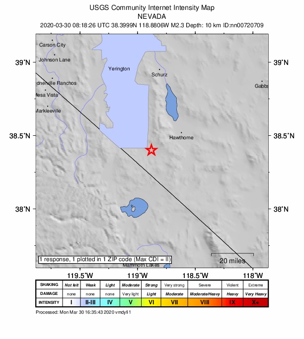
1 person reported to the USGS what they felt; the strongest reported shaking was II, weak shaking.
How well it is located
Reviewed by a seismologist.
- Magnitude uncertainty
- ±0.36
- Station coverage gap
- 55°
- Stations used
- 22
Nearest places
Distance and direction from each place to the epicenter, with its forecast.
Nearby
Within 100 km, magnitude 1.5 and up: at least 201 in the 60 days after this one and 68 in the 30 days before it.
After
- 2.216km WSW of Toms Place, CA · 2376 days ago · 7 km deep · 100 km away
- 1.815 km NNE of Hawthorne, Nevada · 2375 days ago · 7 km deep · 41 km away
- 1.95km SSW of Mammoth Lakes, CA · 2374 days ago · 1 km deep · 90 km away
- 1.75km SW of Mammoth Lakes, CA · 2374 days ago · 0 km deep · 90 km away
- 2.338km SSW of Qualeys Camp, NV · 2374 days ago · 9 km deep · 49 km away
- 1.839km SSW of Qualeys Camp, NV · 2374 days ago · 8 km deep · 51 km away
- 4.016km WSW of Toms Place, CA · 2371 days ago · 8 km deep · 97 km away · felt by 449
- 2.716km WSW of Toms Place, CA · 2371 days ago · 7 km deep · 97 km away · felt by 2
- 1.610 km NNW of Mina, Nevada · 2371 days ago · 8 km deep · 63 km away
- 1.814km SSW of Bridgeport, CA · 2369 days ago · 3 km deep · 45 km away
- 2.04km SW of Bridgeport, CA · 2367 days ago · 2 km deep · 38 km away
- 2.010km ENE of Mammoth Lakes, CA · 2367 days ago · 5 km deep · 83 km away
- 1.68km E of Mammoth Lakes, CA · 2367 days ago · 5 km deep · 85 km away
- 2.522km N of Bridgeport, CA · 2366 days ago · 10 km deep · 34 km away
- 2.214km WSW of Toms Place, CA · 2366 days ago · 3 km deep · 97 km away
- 5.230km SE of Bodie, CA · 2366 days ago · 8 km deep · 41 km away · felt by 1,739
- 2.631km ESE of Bodie, CA · 2366 days ago · 4 km deep · 41 km away
- 3.029km SE of Bodie, CA · 2366 days ago · 9 km deep · 40 km away
- 2.134 km ENE of Lee Vining, California · 2366 days ago · 10 km deep · 41 km away
- 2.030km SE of Bodie, CA · 2366 days ago · 6 km deep · 42 km away
- 1.729km SE of Bodie, CA · 2366 days ago · 5 km deep · 41 km away
- 2.431km SE of Bodie, CA · 2366 days ago · 5 km deep · 41 km away
- 2.630km SE of Bodie, CA · 2366 days ago · 3 km deep · 41 km away
- 2.030km SE of Bodie, CA · 2366 days ago · 4 km deep · 40 km away
- 2.030km SE of Bodie, CA · 2366 days ago · 4 km deep · 40 km away
- 1.829km SE of Bodie, CA · 2366 days ago · 5 km deep · 41 km away
- 3.530km ESE of Bodie, CA · 2366 days ago · 6 km deep · 40 km away · felt by 16
- 2.430km SE of Bodie, CA · 2366 days ago · 6 km deep · 40 km away
- 1.530km SE of Bodie, CA · 2366 days ago · 5 km deep · 40 km away
- 1.929km SE of Bodie, CA · 2366 days ago · -2 km deep · 40 km away
- 2.831km ESE of Bodie, CA · 2366 days ago · 6 km deep · 41 km away · felt by 5
- 2.831km ESE of Bodie, CA · 2366 days ago · 1 km deep · 40 km away · felt by 1
- 1.929km SE of Bodie, CA · 2366 days ago · 3 km deep · 41 km away
- 2.530km SE of Bodie, CA · 2366 days ago · 6 km deep · 40 km away
- 1.530km SE of Bodie, CA · 2366 days ago · 5 km deep · 41 km away
- 2.429km SE of Bodie, CA · 2366 days ago · 8 km deep · 41 km away
- 2.530km SE of Bodie, CA · 2366 days ago · 4 km deep · 40 km away
- 1.830km SE of Bodie, CA · 2366 days ago · 3 km deep · 41 km away
- 2.130km SE of Bodie, CA · 2366 days ago · 3 km deep · 40 km away
- 1.729km SE of Bodie, CA · 2366 days ago · 5 km deep · 41 km away
- 2.129km SE of Bodie, CA · 2366 days ago · 9 km deep · 41 km away
- 1.629km SE of Bodie, CA · 2366 days ago · 6 km deep · 41 km away
- 3.029km SE of Bodie, CA · 2366 days ago · 10 km deep · 41 km away · felt by 5
- 2.230km SE of Bodie, CA · 2366 days ago · 4 km deep · 40 km away
- 2.030km SE of Bodie, CA · 2366 days ago · 3 km deep · 41 km away
- 1.630km SE of Bodie, CA · 2366 days ago · 3 km deep · 40 km away
- 2.530km SE of Bodie, CA · 2366 days ago · 6 km deep · 41 km away
- 1.730km SE of Bodie, CA · 2366 days ago · 3 km deep · 40 km away
- 2.230km SE of Bodie, CA · 2366 days ago · 5 km deep · 40 km away
- 3.331km ESE of Bodie, CA · 2366 days ago · 3 km deep · 41 km away · felt by 2
- 1.630km SE of Bodie, CA · 2366 days ago · 6 km deep · 41 km away
- 1.729km ESE of Bodie, CA · 2366 days ago · 3 km deep · 39 km away
- 2.129km SE of Bodie, CA · 2366 days ago · 3 km deep · 41 km away
- 1.729km SE of Bodie, CA · 2366 days ago · 5 km deep · 40 km away
- 1.634 km NW of Benton, California · 2366 days ago · 8 km deep · 41 km away
- 2.430km SE of Bodie, CA · 2366 days ago · 0 km deep · 41 km away
- 2.630km SE of Bodie, CA · 2366 days ago · 3 km deep · 40 km away · felt by 2
- 1.630km SE of Bodie, CA · 2366 days ago · 6 km deep · 41 km away
- 2.130km SE of Bodie, CA · 2366 days ago · 6 km deep · 41 km away
- 2.030km SE of Bodie, CA · 2366 days ago · 8 km deep · 41 km away
The first 60 of at least 201.
Before
- 2.226 km WSW of Hawthorne, Nevada · 2378 days ago · 9 km deep · 0 km away
- 1.64km E of Mammoth Lakes, CA · 2382 days ago · 6 km deep · 85 km away
- 1.63km E of Mammoth Lakes, CA · 2383 days ago · 5 km deep · 85 km away
- 1.73km E of Mammoth Lakes, CA · 2383 days ago · 5 km deep · 85 km away
- 1.63km E of Mammoth Lakes, CA · 2383 days ago · 5 km deep · 85 km away
- 2.14km E of Mammoth Lakes, CA · 2383 days ago · 6 km deep · 85 km away
- 1.84km E of Mammoth Lakes, CA · 2383 days ago · 5 km deep · 85 km away
- 2.74km E of Mammoth Lakes, CA · 2383 days ago · 6 km deep · 85 km away · felt by 2
- 2.24km E of Mammoth Lakes, CA · 2383 days ago · 5 km deep · 85 km away
- 1.64km ESE of Mammoth Lakes, CA · 2383 days ago · 6 km deep · 87 km away
- 1.84km E of Mammoth Lakes, CA · 2383 days ago · 6 km deep · 85 km away
- 2.34km E of Mammoth Lakes, CA · 2383 days ago · 6 km deep · 85 km away
- 2.04km E of Mammoth Lakes, CA · 2383 days ago · 5 km deep · 84 km away
- 2.33km E of Mammoth Lakes, CA · 2383 days ago · 6 km deep · 85 km away
- 2.14km E of Mammoth Lakes, CA · 2383 days ago · 5 km deep · 85 km away
- 1.94km E of Mammoth Lakes, CA · 2383 days ago · 5 km deep · 85 km away
- 2.54km E of Mammoth Lakes, CA · 2383 days ago · 5 km deep · 85 km away · felt by 1
- 2.24km E of Mammoth Lakes, CA · 2383 days ago · 6 km deep · 85 km away
- 2.74km E of Mammoth Lakes, CA · 2383 days ago · 6 km deep · 85 km away · felt by 9
- 1.64km E of Mammoth Lakes, CA · 2383 days ago · 5 km deep · 85 km away
Earthquakes todayNevada earthquakesLive radar here
Sources
From the USGS Earthquake Hazards Program and its partner networks, event nn00720709 (also filed as us70008ijy). Read Sat, Oct 3, 2026, 4:40 AM UTC.