M7.1 earthquake 1 km SE of Point MacKenzie, Alaska
A magnitude 7.1 earthquake struck 1 km SE of Point MacKenzie, Alaska on Fri, Nov 30, 2018, 8:29 AM AKST (17:29 UTC), 47 km (29 mi) below the surface.
Map
Where this earthquake was located, with the others nearby. Select one for its page.
The earthquake
- Magnitude
- 7.1 (mw), major
- Local time
- UTC
- 2018-11-30 17:29:29 UTC
- Depth
- 46.7 km (29.0 mi), shallow
- Epicenter
- 61.346° N, 149.955° W
- Region
- Alaska
- Felt reports
- 2,342
- Strongest shaking
- VIII, severe shaking
- PAGER alert
- Orange
- Tsunami flag
- Yes: a large quake in an oceanic region
- Status
- Reviewed by a seismologist
Deaths and damage
From NOAA NCEI’s Significant Earthquake Database (record 10376), matched to this event by time and place.
- Injuries
- 117
- Damage
- $150 million
- Houses destroyed
- 2
- Houses damaged
- 1,650
Where the literature gives no number, NCEI records a description on a scale of 1 to 4, printed here in its words. Damage is in millions of US dollars of the year of the event, not adjusted for inflation.
Tsunami
The USGS flags a quake this large in an oceanic region. The flag does not mean a tsunami happened; the tsunami warning centers decide that, and their messages are below when they issued any.
Current tsunami warnings: tsunami.gov. Warnings in force in the US also appear on our alerts pages.
Shaking
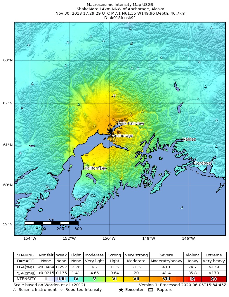
The USGS ShakeMap: shaking estimated from seismic stations and the quake’s size, on the Modified Mercalli intensity scale.
- Strongest estimated
- VIII, severe shaking
- Peak ground acceleration
- 37.6% of gravity
- Peak ground velocity
- 4.0 cm/s
- Map
- Automatic
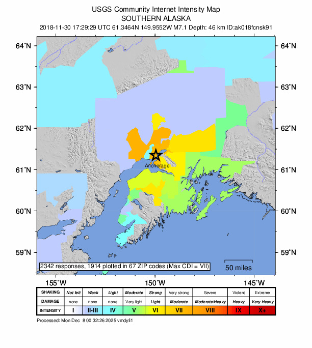
Did you feel it?
2,342 people reported to the USGS what they felt; the strongest reported shaking was VIII, severe shaking.
Estimated impact
The USGS PAGER system estimates deaths and economic losses from the shaking and the population and buildings exposed to it.
- Alert level
- Orange: significant damage and deaths likely, a national response
| Range | Chance |
|---|---|
| Under 1 | 69% |
| 1 to 10 | 29% |
| 10 to 100 | 2% |
| 100 to 1,000 | Under 1% |
| 1,000 to 10,000 | Under 1% |
| 10,000 to 100,000 | Under 1% |
| 100,000 to 10,000,000 | Under 1% |
| Range, million USD | Chance |
|---|---|
| Under 1 | 2% |
| 1 to 10 | 10% |
| 10 to 100 | 28% |
| 100 to 1,000 | 35% |
| 1,000 to 10,000 | 20% |
| 10,000 to 100,000 | 5% |
| 100,000 to 10,000,000 | Under 1% |
Fault motion and ground failure
How the rock slipped, from the moment tensor, and the USGS estimate of landslides and liquefaction.
- Faulting
- Normal
- Moment magnitude
- 7.0 Mww
- Nodal plane 1
- Strike 6°, dip 28°, rake -93°
- Nodal plane 2
- Strike 189°, dip 62°, rake -88°
- Landslide alert
- Orange
- Liquefaction alert
- Orange
How well it is located
Reviewed by a seismologist.
- Stations used
- 389
Nearest places
Distance and direction from each place to the epicenter, with its forecast.
Nearby
Within 100 km, magnitude 4.1 and up: 32 in the 60 days after this one and 0 in the 30 days before it.
After
- 4.54 km NNW of Point MacKenzie, Alaska · 2860 days ago · 47 km deep · 6 km away
- 4.65 km SSE of Big Lake, Alaska · 2860 days ago · 37 km deep · 15 km away
- 4.34 km SE of Point MacKenzie, Alaska · 2860 days ago · 39 km deep · 3 km away · felt by 1
- 5.87 km NNW of Anchorage, Alaska · 2860 days ago · 41 km deep · 7 km away · felt by 122
- 4.97 km N of Anchorage, Alaska · 2860 days ago · 46 km deep · 7 km away
- 4.51 km N of Big Lake, Alaska · 2860 days ago · 43 km deep · 21 km away · felt by 1
- 5.26 km S of Big Lake, Alaska · 2860 days ago · 40 km deep · 13 km away · felt by 79
- 4.81 km NW of Point MacKenzie, Alaska · 2860 days ago · 40 km deep · 4 km away · felt by 146 · tsunami flag
- 4.49 km NW of Eagle River, Alaska · 2860 days ago · 35 km deep · 13 km away · felt by 1
- 4.26 km SSE of Big Lake, Alaska · 2860 days ago · 37 km deep · 14 km away
- 5.0Southern Alaska · 2860 days ago · 38 km deep · 8 km away · felt by 172 · tsunami flag
- 4.57 km WNW of Point MacKenzie, Alaska · 2860 days ago · 37 km deep · 9 km away · felt by 3
- 4.11 km NNE of Big Lake, Alaska · 2860 days ago · 40 km deep · 21 km away
- 4.61 km N of Point MacKenzie, Alaska · 2859 days ago · 45 km deep · 4 km away · felt by 207 · tsunami flag
- 4.36 km S of Big Lake, Alaska · 2859 days ago · 33 km deep · 13 km away · felt by 4
- 5.04 km SSE of Big Lake, Alaska · 2859 days ago · 51 km deep · 15 km away · felt by 68 · tsunami flag
- 5.10 km SW of Point MacKenzie, Alaska · 2859 days ago · 43 km deep · 2 km away · felt by 234 · tsunami flag
- 4.11 km SW of Point MacKenzie, Alaska · 2859 days ago · 41 km deep · 2 km away · felt by 24
- 4.56 km SSE of Big Lake, Alaska · 2859 days ago · 34 km deep · 14 km away · felt by 40 · tsunami flag
- 4.55 km SE of Point MacKenzie, Alaska · 2858 days ago · 52 km deep · 4 km away · felt by 205 · tsunami flag
- 4.56 km NW of Point MacKenzie, Alaska · 2856 days ago · 38 km deep · 8 km away · felt by 312 · tsunami flag
- 4.55 km SW of Point MacKenzie, Alaska · 2855 days ago · 42 km deep · 6 km away · felt by 334 · tsunami flag
- 4.82 km SSE of Point MacKenzie, Alaska · 2854 days ago · 43 km deep · 1 km away · felt by 556 · tsunami flag
- 4.17 km S of Big Lake, Alaska · 2854 days ago · 56 km deep · 12 km away · felt by 32
- 4.77 km SW of Knik, Alaska · 2851 days ago · 41 km deep · 10 km away · felt by 596 · tsunami flag
- 4.214 km ESE of Susitna, Alaska · 2843 days ago · 62 km deep · 23 km away · felt by 179 · tsunami flag
- 4.89 km SSW of Point MacKenzie, Alaska · 2833 days ago · 41 km deep · 9 km away · felt by 1,190 · tsunami flag
- 5.07 km SSE of Point MacKenzie, Alaska · 2828 days ago · 44 km deep · 5 km away · felt by 1,073 · tsunami flag
- 4.26 km SSE of Point MacKenzie, Alaska · 2827 days ago · 41 km deep · 5 km away · felt by 294
- 4.66 km SSE of Big Lake, Alaska · 2818 days ago · 50 km deep · 14 km away · felt by 740 · tsunami flag
- 5.08 km SW of Point MacKenzie, Alaska · 2816 days ago · 45 km deep · 8 km away · felt by 2,525 · tsunami flag
- 4.515 km W of Big Lake, Alaska · 2806 days ago · 46 km deep · 23 km away · felt by 1,119 · tsunami flag
Earthquakes todayAlaska earthquakesLive radar here
Sources
From the USGS Earthquake Hazards Program and its partner networks, event ak018fcnsk91 (also filed as ak20419010, at00pj0ol4, us1000hyfh, pt18334000, iscgem616643636). Read Tue, Sep 29, 2026, 1:05 PM UTC.