M5.0 earthquake 8 km SW of Point MacKenzie, Alaska
A magnitude 5.0 earthquake struck 8 km SW of Point MacKenzie, Alaska on Sun, Jan 13, 2019, 7:45 AM AKST (16:45 UTC), 45 km (28 mi) below the surface.
Map
Where this earthquake was located, with the others nearby. Select one for its page.
The earthquake
- Magnitude
- 5.0 (ml), moderate
- Local time
- UTC
- 2019-01-13 16:45:55 UTC
- Depth
- 44.8 km (27.8 mi), shallow
- Epicenter
- 61.299° N, 150.065° W
- Region
- Alaska
- Felt reports
- 2,525
- Strongest shaking
- V, moderate shaking
- PAGER alert
- Green
- Tsunami flag
- Yes: a large quake in an oceanic region
- Status
- Reviewed by a seismologist
Tsunami
The USGS flags a quake this large in an oceanic region. The flag does not mean a tsunami happened; the tsunami warning centers decide that, and their messages are below when they issued any.
Current tsunami warnings: tsunami.gov. Warnings in force in the US also appear on our alerts pages.
Shaking
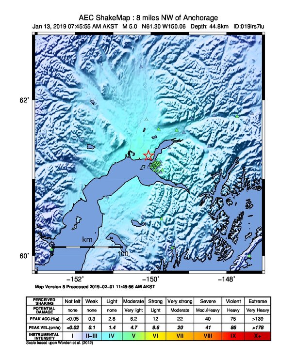
The USGS ShakeMap: shaking estimated from seismic stations and the quake’s size, on the Modified Mercalli intensity scale.
- Strongest estimated
- V, moderate shaking
- Peak ground acceleration
- 1087.0% of gravity
- Peak ground velocity
- 4.5 cm/s
- Map
- Automatic
Did you feel it?
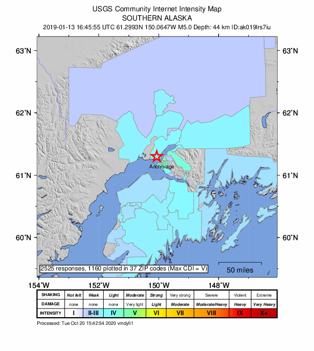
2,525 people reported to the USGS what they felt; the strongest reported shaking was V, moderate shaking.
Estimated impact
The USGS PAGER system estimates deaths and economic losses from the shaking and the population and buildings exposed to it.
- Alert level
- Green: little or no damage or loss of life expected
| Range | Chance |
|---|---|
| Under 1 | 69% |
| 1 to 10 | 29% |
| 10 to 100 | 2% |
| 100 to 1,000 | Under 1% |
| 1,000 to 10,000 | Under 1% |
| 10,000 to 100,000 | Under 1% |
| 100,000 to 10,000,000 | Under 1% |
| Range, million USD | Chance |
|---|---|
| Under 1 | 65% |
| 1 to 10 | 30% |
| 10 to 100 | 4% |
| 100 to 1,000 | Under 1% |
| 1,000 to 10,000 | Under 1% |
| 10,000 to 100,000 | Under 1% |
| 100,000 to 10,000,000 | Under 1% |
Fault motion and ground failure
How the rock slipped, from the moment tensor, and the USGS estimate of landslides and liquefaction.
- Faulting
- Oblique normal
- Moment magnitude
- 5.0 Mww
- Nodal plane 1
- Strike 334°, dip 36°, rake -127°
- Nodal plane 2
- Strike 197°, dip 62°, rake -66°
- Landslide alert
- Green
- Liquefaction alert
- Green
How well it is located
Reviewed by a seismologist.
- Stations used
- 260
Nearest places
Distance and direction from each place to the epicenter, with its forecast.
Nearby
Within 100 km, magnitude 2.0 and up: at least 199 in the 60 days after this one and at least 200 in the 30 days before it.
After
- 2.78 km SW of Point MacKenzie, Alaska · 2816 days ago · 42 km deep · 3 km away
- 2.18 km SW of Point MacKenzie, Alaska · 2816 days ago · 51 km deep · 2 km away
- 2.34 km N of Anchorage, Alaska · 2816 days ago · 44 km deep · 9 km away · felt by 5
- 2.79 km SW of Point MacKenzie, Alaska · 2815 days ago · 42 km deep · 3 km away · felt by 1
- 3.03 km W of Point MacKenzie, Alaska · 2815 days ago · 45 km deep · 7 km away · felt by 15
- 2.29 km SW of Point MacKenzie, Alaska · 2815 days ago · 42 km deep · 3 km away
- 2.06 km SSE of Big Lake, Alaska · 2815 days ago · 43 km deep · 20 km away
- 2.28 km E of Salamatof, Alaska · 2815 days ago · 65 km deep · 96 km away
- 2.0Southern Alaska · 2815 days ago · 45 km deep · 3 km away
- 2.54 km NE of Point MacKenzie, Alaska · 2815 days ago · 39 km deep · 13 km away · felt by 1
- 2.02 km ESE of Big Lake, Alaska · 2815 days ago · 43 km deep · 25 km away
- 3.77 km WSW of Knik, Alaska · 2815 days ago · 39 km deep · 18 km away · felt by 142
- 2.24 km NW of Point MacKenzie, Alaska · 2815 days ago · 45 km deep · 10 km away
- 2.3Southern Alaska · 2814 days ago · 37 km deep · 10 km away
- 2.33 km SSE of Big Lake, Alaska · 2814 days ago · 41 km deep · 23 km away
- 2.148 km SSW of Skwentna, Alaska · 2814 days ago · 83 km deep · 98 km away
- 2.33 km SSW of Big Lake, Alaska · 2814 days ago · 46 km deep · 22 km away
- 2.28 km NW of Point MacKenzie, Alaska · 2813 days ago · 40 km deep · 13 km away
- 2.15 km NW of Point MacKenzie, Alaska · 2813 days ago · 40 km deep · 11 km away
- 2.37 km S of Big Lake, Alaska · 2813 days ago · 44 km deep · 18 km away
- 2.47 km NW of Point MacKenzie, Alaska · 2813 days ago · 42 km deep · 12 km away
- 2.32 km SSE of Big Lake, Alaska · 2812 days ago · 41 km deep · 23 km away
- 2.12 km WSW of Point MacKenzie, Alaska · 2812 days ago · 41 km deep · 6 km away
- 2.56 km SSE of Big Lake, Alaska · 2812 days ago · 31 km deep · 21 km away · felt by 1
- 2.16 km ESE of Big Lake, Alaska · 2811 days ago · 44 km deep · 26 km away
- 2.2Southern Alaska · 2811 days ago · 48 km deep · 18 km away
- 2.08 km N of Point MacKenzie, Alaska · 2811 days ago · 44 km deep · 15 km away
- 2.26 km NNE of Point MacKenzie, Alaska · 2811 days ago · 46 km deep · 15 km away
- 2.05 km SSE of Big Lake, Alaska · 2810 days ago · 36 km deep · 21 km away
- 2.28 km WSW of Point MacKenzie, Alaska · 2810 days ago · 42 km deep · 3 km away
- 2.28 km NW of Point MacKenzie, Alaska · 2809 days ago · 40 km deep · 12 km away · felt by 1
- 2.16 km NW of Point MacKenzie, Alaska · 2809 days ago · 35 km deep · 12 km away
- 2.12 km SSW of Big Lake, Alaska · 2809 days ago · 44 km deep · 23 km away
- 2.510 km NW of Point MacKenzie, Alaska · 2808 days ago · 34 km deep · 14 km away
- 2.46 km NW of Point MacKenzie, Alaska · 2808 days ago · 39 km deep · 11 km away
- 2.2Southern Alaska · 2807 days ago · 45 km deep · 11 km away
- 2.626 km NW of Beluga, Alaska · 2807 days ago · 71 km deep · 72 km away
- 2.73 km SSE of Big Lake, Alaska · 2807 days ago · 43 km deep · 23 km away · felt by 3
- 2.23 km NE of Big Lake, Alaska · 2807 days ago · 54 km deep · 29 km away
- 2.38 km SW of Big Lake, Alaska · 2806 days ago · 36 km deep · 18 km away
- 4.515 km W of Big Lake, Alaska · 2806 days ago · 46 km deep · 24 km away · felt by 1,119 · tsunami flag
- 2.314 km W of Big Lake, Alaska · 2806 days ago · 47 km deep · 24 km away · felt by 1
- 2.56 km NNE of Point MacKenzie, Alaska · 2806 days ago · 35 km deep · 15 km away · felt by 3
- 2.11 km SW of Point MacKenzie, Alaska · 2806 days ago · 37 km deep · 7 km away · felt by 1
- 2.55 km WNW of Point MacKenzie, Alaska · 2806 days ago · 39 km deep · 8 km away
- 3.214 km WSW of Big Lake, Alaska · 2806 days ago · 49 km deep · 23 km away · felt by 10
- 2.72 km NNW of Knik, Alaska · 2806 days ago · 38 km deep · 27 km away · felt by 1
- 3.89 km SW of Point MacKenzie, Alaska · 2806 days ago · 44 km deep · 1 km away · felt by 137
- 2.49 km SSW of Big Lake, Alaska · 2805 days ago · 40 km deep · 17 km away
- 2.04 km W of Point MacKenzie, Alaska · 2805 days ago · 40 km deep · 7 km away
- 2.014 km ESE of Susitna, Alaska · 2805 days ago · 43 km deep · 25 km away
- 2.06 km W of Point MacKenzie, Alaska · 2805 days ago · 32 km deep · 8 km away
- 2.413 km WSW of Big Lake, Alaska · 2805 days ago · 46 km deep · 23 km away
- 3.03 km ESE of Big Lake, Alaska · 2805 days ago · 36 km deep · 25 km away · felt by 4
- 2.97 km WNW of Point MacKenzie, Alaska · 2805 days ago · 43 km deep · 10 km away · felt by 6
- 2.36 km NNW of Point MacKenzie, Alaska · 2804 days ago · 44 km deep · 12 km away
- 3.114 km WSW of Big Lake, Alaska · 2804 days ago · 46 km deep · 23 km away · felt by 7
- 2.513 km W of Big Lake, Alaska · 2804 days ago · 48 km deep · 25 km away
- 2.050 km S of Skwentna, Alaska · 2804 days ago · 78 km deep · 85 km away
- 2.16 km NW of Point MacKenzie, Alaska · 2804 days ago · 41 km deep · 11 km away
The first 60 of at least 199.
Before
- 2.0Southern Alaska · 2816 days ago · 67 km deep · 53 km away
- 2.6Southern Alaska · 2817 days ago · 38 km deep · 34 km away · felt by 26
- 2.82 km ESE of Big Lake, Alaska · 2817 days ago · 39 km deep · 25 km away · felt by 3
- 2.59 km E of Point MacKenzie, Alaska · 2817 days ago · 55 km deep · 16 km away · felt by 7
- 2.33 km WNW of Point MacKenzie, Alaska · 2817 days ago · 37 km deep · 8 km away
- 2.14 km SSE of Big Lake, Alaska · 2817 days ago · 43 km deep · 22 km away
- 2.16 km WNW of Point MacKenzie, Alaska · 2818 days ago · 43 km deep · 10 km away
- 2.26 km S of Big Lake, Alaska · 2818 days ago · 49 km deep · 20 km away
- 2.67 km NNE of Point MacKenzie, Alaska · 2818 days ago · 37 km deep · 16 km away
- 2.19 km NNE of Point MacKenzie, Alaska · 2818 days ago · 39 km deep · 18 km away
- 2.43 km SSE of Big Lake, Alaska · 2818 days ago · 47 km deep · 23 km away
- 3.86 km SE of Big Lake, Alaska · 2818 days ago · 49 km deep · 22 km away · felt by 34
- 2.34 km SSW of Point MacKenzie, Alaska · 2818 days ago · 43 km deep · 4 km away
- 2.27 km SSE of Big Lake, Alaska · 2818 days ago · 42 km deep · 19 km away · felt by 1
- 2.227 km N of Fishhook, Alaska · 2818 days ago · 11 km deep · 87 km away · felt by 4
- 2.57 km NW of Eagle River, Alaska · 2818 days ago · 36 km deep · 23 km away
- 2.35 km SE of Big Lake, Alaska · 2818 days ago · 46 km deep · 22 km away · felt by 1
- 2.34 km S of Big Lake, Alaska · 2818 days ago · 49 km deep · 21 km away
- 4.66 km SSE of Big Lake, Alaska · 2818 days ago · 50 km deep · 21 km away · felt by 740 · tsunami flag
- 2.44 km S of Big Lake, Alaska · 2818 days ago · 46 km deep · 21 km away
Earthquakes todayAlaska earthquakesLive radar here
Sources
From the USGS Earthquake Hazards Program and its partner networks, event ak019lrs7iu (also filed as at00pla3wj, us2000j3j9, iscgem614569375). Read Tue, Sep 29, 2026, 12:16 PM UTC.