M4.6 earthquake 20 km SSE of Salina Cruz, Mexico
A magnitude 4.6 earthquake struck 20 km SSE of Salina Cruz, Mexico on Tue, Sep 19, 2017, 10:28 PM CDT (03:28 UTC), 35 km (22 mi) below the surface.
A larger quake followed: M6.1 7 km NNE of Ixtepec, Mexico. This one was a foreshock.
Map
Where this earthquake was located, with the others nearby. Select one for its page.
The earthquake
- Magnitude
- 4.6 (mb, body-wave), light
- Magnitude from
- USGS National Earthquake Information Center
- Local time
- UTC
- 2017-09-20 03:28:02 UTC
- Depth
- 35.0 km (21.7 mi), shallow
- Epicenter
- 16.004° N, 95.119° W
- Region
- Mexico
- Felt reports
- 3
- Tsunami flag
- No
- Status
- Reviewed by a seismologist
Did you feel it?
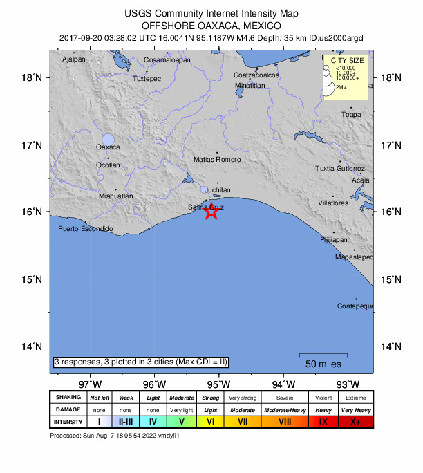
3 people reported to the USGS what they felt; the strongest reported shaking was II, weak shaking.
How well it is located
Reviewed by a seismologist.
- Location uncertainty
- About 4.9 km horizontally, 2.0 km in depth
- Magnitude uncertainty
- ±0.04
- Depth from
- Operator assigned
- Station coverage gap
- 151°
- Stations used
- 87
Nearest places
Distance and direction from each place to the epicenter, with its forecast.
Nearby
Within 100 km, magnitude 1.6 and up: 100 in the 60 days after this one and 163 in the 30 days before it.
After
- 4.567 km SE of El Carrizal, Mexico · 3300 days ago · 35 km deep · 49 km away
- 4.022 km SSE of Salina Cruz, Mexico · 3300 days ago · 37 km deep · 4 km away
- 3.952 km SSE of San Francisco del Mar Viejo, Mexico · 3299 days ago · 36 km deep · 74 km away
- 4.134 km SSE of El Carrizal, Mexico · 3299 days ago · 33 km deep · 34 km away
- 4.259 km SE of El Carrizal, Mexico · 3298 days ago · 21 km deep · 39 km away
- 4.126 km SE of El Carrizal, Mexico · 3298 days ago · 35 km deep · 11 km away
- 4.268 km SSE of El Carrizal, Mexico · 3297 days ago · 35 km deep · 58 km away · felt by 2
- 4.155 km SW of La Gloria, Mexico · 3297 days ago · 41 km deep · 77 km away · felt by 1
- 5.880 km SSW of La Gloria, Mexico · 3296 days ago · 54 km deep · 93 km away · felt by 26
- 6.17 km NNE of Ixtepec, Mexico · 3296 days ago · 10 km deep · 69 km away · felt by 205 · PAGER yellow
- 4.94 km SE of Colonia Jordán, Mexico · 3296 days ago · 62 km deep · 40 km away
- 4.81 km SSW of Santo Domingo Chihuitán, Mexico · 3296 days ago · 21 km deep · 64 km away · felt by 3
- 4.82 km N of Juchitán de Zaragoza, Mexico · 3296 days ago · 38 km deep · 51 km away · felt by 1
- 4.25 km WNW of Santa Rosa, Mexico · 3296 days ago · 81 km deep · 37 km away
- 4.42 km N of Santiago Laollaga, Mexico · 3296 days ago · 45 km deep · 68 km away
- 4.13 km NNE of Colonia Jordán, Mexico · 3296 days ago · 54 km deep · 47 km away
- 4.96 km N of La Ventosa, Mexico · 3296 days ago · 38 km deep · 70 km away · felt by 6
- 4.19 km SW of Niltepec, Mexico · 3296 days ago · 53 km deep · 73 km away
- 4.21 km SSW of Colonia Jordán, Mexico · 3296 days ago · 44 km deep · 43 km away
- 4.44 km WSW of Unión Hidalgo, Mexico · 3296 days ago · 60 km deep · 57 km away
- 4.40 km NE of Ixtepec, Mexico · 3296 days ago · 12 km deep · 62 km away
- 4.14 km SSW of Magdalena Tlacotepec, Mexico · 3296 days ago · 17 km deep · 53 km away
- 4.51 km NNE of Ixtepec, Mexico · 3296 days ago · 35 km deep · 64 km away
- 4.20 km W of San Pedro Huilotepec, Mexico · 3296 days ago · 76 km deep · 27 km away
- 4.07 km SW of Rincón Moreno, Mexico · 3296 days ago · 10 km deep · 33 km away
- 4.03 km NE of Colonia Jordán, Mexico · 3296 days ago · 22 km deep · 46 km away
- 4.375 km SSE of San Mateo del Mar, Mexico · 3295 days ago · 40 km deep · 60 km away
- 4.53 km NNW of Colonia Jordán, Mexico · 3295 days ago · 21 km deep · 48 km away
- 4.28 km N of Santa Rosa, Mexico · 3295 days ago · 10 km deep · 44 km away
- 4.774 km SSW of La Gloria, Mexico · 3295 days ago · 45 km deep · 84 km away
- 4.244 km SSE of San Mateo del Mar, Mexico · 3295 days ago · 37 km deep · 39 km away
- 4.376 km SSE of San Mateo del Mar, Mexico · 3295 days ago · 37 km deep · 62 km away
- 4.584 km S of San Francisco del Mar Viejo, Mexico · 3295 days ago · 39 km deep · 74 km away
- 4.584 km SSE of San Mateo del Mar, Mexico · 3295 days ago · 41 km deep · 69 km away
- 4.22 km NW of Colonia Jordán, Mexico · 3294 days ago · 47 km deep · 46 km away
- 4.48 km SSE of San Pedro Comitancillo, Mexico · 3294 days ago · 41 km deep · 47 km away
- 4.4100 km S of San Francisco del Mar Viejo, Mexico · 3294 days ago · 30 km deep · 96 km away
- 4.683 km S of San Francisco del Mar Viejo, Mexico · 3294 days ago · 28 km deep · 77 km away
- 4.32 km E of Santa María Xadani, Mexico · 3294 days ago · 78 km deep · 42 km away
- 4.4110 km S of San Francisco del Mar Viejo, Mexico · 3293 days ago · 35 km deep · 100 km away
- 4.085 km SSE of El Carrizal, Mexico · 3293 days ago · 37 km deep · 72 km away
- 4.166 km SSE of San Francisco del Mar Viejo, Mexico · 3293 days ago · 42 km deep · 79 km away
- 4.37 km N of Santa Rosa, Mexico · 3293 days ago · 65 km deep · 42 km away · felt by 1
- 4.32 km SSW of Magdalena Tlacotepec, Mexico · 3292 days ago · 16 km deep · 54 km away · felt by 1
- 4.08 km SSE of Rincón Moreno, Mexico · 3292 days ago · 10 km deep · 25 km away
- 4.466 km S of San Mateo del Mar, Mexico · 3290 days ago · 38 km deep · 47 km away
- 4.432 km SSE of Salina Cruz, Mexico · 3290 days ago · 35 km deep · 12 km away
- 4.812 km SSE of San Mateo del Mar, Mexico · 3289 days ago · 49 km deep · 25 km away · felt by 1
- 4.180 km SSE of San Mateo del Mar, Mexico · 3289 days ago · 20 km deep · 65 km away
- 4.265 km S of San Francisco del Mar Viejo, Mexico · 3288 days ago · 35 km deep · 64 km away
- 4.499 km SSE of San Mateo del Mar, Mexico · 3288 days ago · 35 km deep · 84 km away
- 4.210 km ENE of Santa María Jalapa del Marqués, Mexico · 3288 days ago · 10 km deep · 57 km away
- 4.08 km SSE of Santa María Ecatepec, Mexico · 3287 days ago · 10 km deep · 83 km away
- 4.289 km S of San Francisco del Mar Viejo, Mexico · 3286 days ago · 28 km deep · 80 km away
- 4.072 km S of El Carrizal, Mexico · 3286 days ago · 9 km deep · 68 km away
- 4.448 km S of San Mateo del Mar, Mexico · 3285 days ago · 11 km deep · 31 km away
- 4.33 km ENE of San Pedro Comitancillo, Mexico · 3285 days ago · 10 km deep · 55 km away · felt by 1
- 4.258 km SSE of San Francisco del Mar Viejo, Mexico · 3285 days ago · 42 km deep · 71 km away
- 4.158 km SSE of El Carrizal, Mexico · 3284 days ago · 67 km deep · 44 km away
- 4.16 km SW of El Espinal, Mexico · 3283 days ago · 10 km deep · 50 km away · felt by 1
The first 60 of 100.
Before
- 4.613 km ENE of San Mateo del Mar, Mexico · 3300 days ago · 45 km deep · 38 km away · felt by 2
- 5.0108 km S of San Francisco del Mar Viejo, Mexico · 3300 days ago · 23 km deep · 93 km away · felt by 1
- 4.458 km SSE of El Carrizal, Mexico · 3300 days ago · 21 km deep · 53 km away
- 4.963 km S of San Francisco del Mar Viejo, Mexico · 3301 days ago · 55 km deep · 63 km away
- 4.377 km S of San Francisco del Mar Viejo, Mexico · 3301 days ago · 34 km deep · 66 km away
- 4.3101 km S of San Francisco del Mar Viejo, Mexico · 3301 days ago · 35 km deep · 95 km away
- 4.3116 km SSE of San Mateo del Mar, Mexico · 3301 days ago · 27 km deep · 100 km away
- 4.9102 km S of San Mateo del Mar, Mexico · 3301 days ago · 20 km deep · 85 km away
- 4.144 km SSE of El Carrizal, Mexico · 3301 days ago · 10 km deep · 40 km away
- 4.342 km SSE of El Carrizal, Mexico · 3301 days ago · 40 km deep · 38 km away
- 4.219 km SE of San Mateo del Mar, Mexico · 3301 days ago · 41 km deep · 31 km away
- 4.918 km ESE of El Carrizal, Mexico · 3301 days ago · 6 km deep · 12 km away · felt by 1
- 4.086 km SE of El Carrizal, Mexico · 3302 days ago · 34 km deep · 68 km away
- 4.127 km S of Salina Cruz, Mexico · 3302 days ago · 35 km deep · 9 km away
- 4.080 km SSW of La Gloria, Mexico · 3302 days ago · 8 km deep · 90 km away
- 5.033 km SSE of El Carrizal, Mexico · 3303 days ago · 10 km deep · 33 km away
- 4.519 km S of Colonia Juárez, Mexico · 3303 days ago · 51 km deep · 8 km away
- 4.072 km SSE of El Carrizal, Mexico · 3303 days ago · 13 km deep · 63 km away
- 4.041 km SSE of El Carrizal, Mexico · 3303 days ago · 20 km deep · 35 km away
- 5.1111 km S of San Francisco del Mar Viejo, Mexico · 3303 days ago · 13 km deep · 98 km away
Earthquakes todayMexico earthquakesLive radar here
Sources
From the USGS Earthquake Hazards Program and its partner networks, event us2000argd. Read Fri, Oct 2, 2026, 9:18 PM UTC.