M6.1 earthquake 7 km NNE of Ixtepec, Mexico
A magnitude 6.1 earthquake struck 7 km NNE of Ixtepec, Mexico on Sat, Sep 23, 2017, 7:53 AM CDT (12:53 UTC), 10 km (6 mi) below the surface.
Map
Where this earthquake was located, with the others nearby. Select one for its page.
The earthquake
- Magnitude
- 6.1 (mww), strong
- Local time
- UTC
- 2017-09-23 12:53:01 UTC
- Depth
- 10.0 km (6.2 mi), shallow
- Epicenter
- 16.626° N, 95.078° W
- Region
- Mexico
- Felt reports
- 205
- Strongest shaking
- VI, strong shaking
- PAGER alert
- Yellow
- Tsunami flag
- No
- Status
- Reviewed by a seismologist
Deaths and damage
From NOAA NCEI’s Significant Earthquake Database (record 10268), matched to this event by time and place.
- Deaths
- 5
- Injuries
- 7
- Damage
- Limited (under about $1 million)
- Houses destroyed
- 11
Where the literature gives no number, NCEI records a description on a scale of 1 to 4, printed here in its words. Damage is in millions of US dollars of the year of the event, not adjusted for inflation.
Shaking
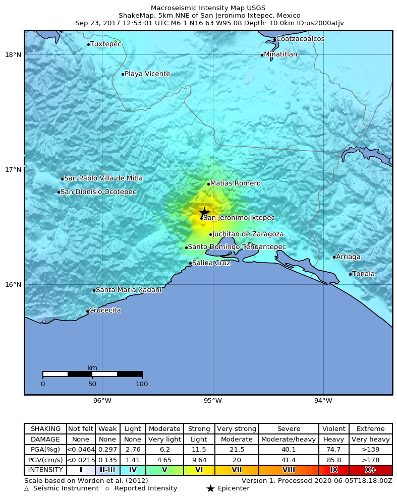
The USGS ShakeMap: shaking estimated from seismic stations and the quake’s size, on the Modified Mercalli intensity scale.
- Strongest estimated
- VI, strong shaking
- Peak ground acceleration
- 25.6% of gravity
- Peak ground velocity
- 3.3 cm/s
- Map
- Automatic
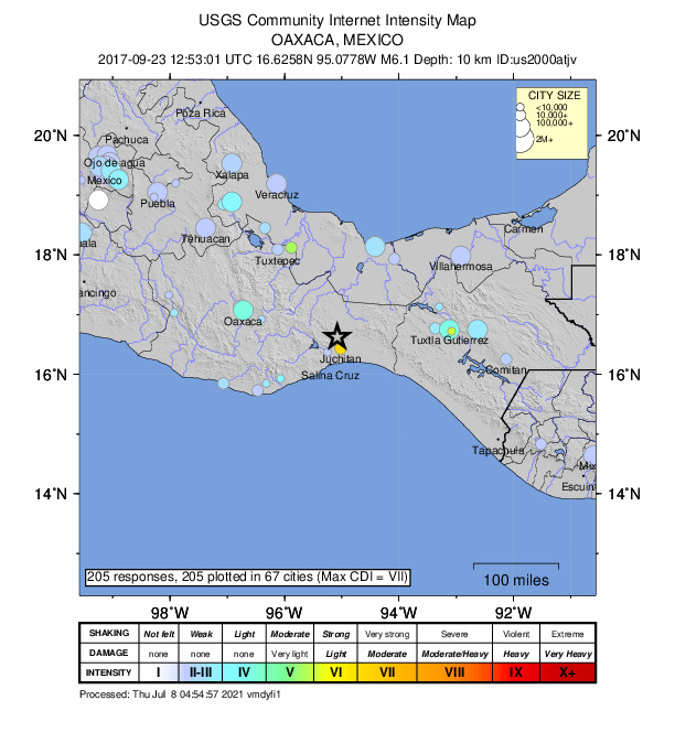
Did you feel it?
205 people reported to the USGS what they felt; the strongest reported shaking was VII, very strong shaking.
Estimated impact
The USGS PAGER system estimates deaths and economic losses from the shaking and the population and buildings exposed to it.
- Alert level
- Yellow: some damage and deaths possible, a local or regional response
| Range | Chance |
|---|---|
| Under 1 | 12% |
| 1 to 10 | 32% |
| 10 to 100 | 37% |
| 100 to 1,000 | 16% |
| 1,000 to 10,000 | 3% |
| 10,000 to 100,000 | Under 1% |
| 100,000 to 10,000,000 | Under 1% |
| Range, million USD | Chance |
|---|---|
| Under 1 | 9% |
| 1 to 10 | 27% |
| 10 to 100 | 38% |
| 100 to 1,000 | 21% |
| 1,000 to 10,000 | 5% |
| 10,000 to 100,000 | Under 1% |
| 100,000 to 10,000,000 | Under 1% |
Fault motion and ground failure
How the rock slipped, from the moment tensor, and the USGS estimate of landslides and liquefaction.
- Faulting
- Normal
- Moment magnitude
- 6.1 Mww
- Nodal plane 1
- Strike 234°, dip 38°, rake -110°
- Nodal plane 2
- Strike 79°, dip 55°, rake -75°
How well it is located
Reviewed by a seismologist.
- Location uncertainty
- About 3.8 km horizontally, 1.7 km in depth
- Magnitude uncertainty
- ±0.04
- Depth from
- From modeling of broad-band P waveforms
- Station coverage gap
- 31°
- Stations used
- 434
Nearest places
Distance and direction from each place to the epicenter, with its forecast.
Nearby
Within 100 km, magnitude 3.1 and up: 61 in the 60 days after this one and 36 in the 30 days before it.
After
- 4.94 km SE of Colonia Jordán, Mexico · 3294 days ago · 62 km deep · 32 km away
- 4.81 km SSW of Santo Domingo Chihuitán, Mexico · 3294 days ago · 21 km deep · 11 km away · felt by 3
- 4.82 km N of Juchitán de Zaragoza, Mexico · 3294 days ago · 38 km deep · 20 km away · felt by 1
- 4.25 km WNW of Santa Rosa, Mexico · 3294 days ago · 81 km deep · 33 km away
- 4.42 km N of Santiago Laollaga, Mexico · 3294 days ago · 45 km deep · 14 km away
- 4.13 km NNE of Colonia Jordán, Mexico · 3294 days ago · 54 km deep · 26 km away
- 4.96 km N of La Ventosa, Mexico · 3294 days ago · 38 km deep · 14 km away · felt by 6
- 4.27 km S of Santa María Chimalapa, Mexico · 3294 days ago · 40 km deep · 49 km away
- 4.19 km SW of Niltepec, Mexico · 3294 days ago · 53 km deep · 45 km away
- 4.21 km SSW of Colonia Jordán, Mexico · 3294 days ago · 44 km deep · 31 km away
- 4.44 km WSW of Unión Hidalgo, Mexico · 3294 days ago · 60 km deep · 30 km away
- 4.40 km NE of Ixtepec, Mexico · 3294 days ago · 12 km deep · 7 km away
- 4.14 km SSW of Magdalena Tlacotepec, Mexico · 3293 days ago · 17 km deep · 23 km away
- 4.51 km NNE of Ixtepec, Mexico · 3293 days ago · 35 km deep · 6 km away
- 4.20 km W of San Pedro Huilotepec, Mexico · 3293 days ago · 76 km deep · 43 km away
- 4.07 km SW of Rincón Moreno, Mexico · 3293 days ago · 10 km deep · 58 km away
- 4.03 km NE of Colonia Jordán, Mexico · 3293 days ago · 22 km deep · 26 km away
- 4.53 km NNW of Colonia Jordán, Mexico · 3293 days ago · 21 km deep · 27 km away
- 4.28 km N of Santa Rosa, Mexico · 3293 days ago · 10 km deep · 26 km away
- 4.244 km SSE of San Mateo del Mar, Mexico · 3292 days ago · 37 km deep · 91 km away
- 4.22 km NW of Colonia Jordán, Mexico · 3292 days ago · 47 km deep · 29 km away
- 4.48 km SSE of San Pedro Comitancillo, Mexico · 3292 days ago · 41 km deep · 22 km away
- 4.32 km E of Santa María Xadani, Mexico · 3291 days ago · 78 km deep · 31 km away
- 4.37 km N of Santa Rosa, Mexico · 3290 days ago · 65 km deep · 27 km away · felt by 1
- 4.32 km SSW of Magdalena Tlacotepec, Mexico · 3289 days ago · 16 km deep · 21 km away · felt by 1
- 4.08 km SSE of Rincón Moreno, Mexico · 3289 days ago · 10 km deep · 58 km away
- 4.33 km ENE of Paso Real de Sarabia, Mexico · 3289 days ago · 117 km deep · 52 km away
- 4.432 km SSE of Salina Cruz, Mexico · 3287 days ago · 35 km deep · 80 km away
- 4.812 km SSE of San Mateo del Mar, Mexico · 3287 days ago · 49 km deep · 59 km away · felt by 1
- 4.210 km ENE of Santa María Jalapa del Marqués, Mexico · 3285 days ago · 10 km deep · 34 km away
- 4.08 km SSE of Santa María Ecatepec, Mexico · 3284 days ago · 10 km deep · 96 km away
- 4.448 km S of San Mateo del Mar, Mexico · 3283 days ago · 11 km deep · 96 km away
- 4.33 km ENE of San Pedro Comitancillo, Mexico · 3282 days ago · 10 km deep · 15 km away · felt by 1
- 4.13 km W of Palomares, Mexico · 3282 days ago · 33 km deep · 57 km away
- 4.16 km SW of El Espinal, Mexico · 3281 days ago · 10 km deep · 19 km away · felt by 1
- 4.33 km SW of Magdalena Tlacotepec, Mexico · 3280 days ago · 10 km deep · 23 km away
- 4.32 km NE of Magdalena Tlacotepec, Mexico · 3280 days ago · 14 km deep · 17 km away
- 4.19 km NNW of Santo Domingo Chihuitán, Mexico · 3279 days ago · 101 km deep · 13 km away
- 4.15 km WNW of Santa María Xadani, Mexico · 3278 days ago · 10 km deep · 27 km away
- 4.22 km ENE of Colonia Jordán, Mexico · 3277 days ago · 35 km deep · 28 km away · felt by 1
- 4.11 km WNW of San Pedro Comitancillo, Mexico · 3275 days ago · 18 km deep · 17 km away
- 4.15 km E of Colonia Jordán, Mexico · 3274 days ago · 45 km deep · 27 km away
- 4.26 km W of Santa Rosa, Mexico · 3274 days ago · 10 km deep · 36 km away
- 5.512 km E of San Mateo del Mar, Mexico · 3273 days ago · 56 km deep · 50 km away · felt by 34
- 3.98 km S of Colonia Juárez, Mexico · 3272 days ago · 8 km deep · 55 km away
- 4.325 km S of Salina Cruz, Mexico · 3271 days ago · 10 km deep · 76 km away
- 4.241 km S of San Mateo del Mar, Mexico · 3266 days ago · 32 km deep · 89 km away · felt by 1
- 4.24 km E of San Blas Atempa, Mexico · 3264 days ago · 53 km deep · 35 km away
- 4.16 km W of Santa Rosa, Mexico · 3264 days ago · 51 km deep · 36 km away
- 4.636 km SSE of Salina Cruz, Mexico · 3262 days ago · 39 km deep · 85 km away
- 4.029 km SSE of Salina Cruz, Mexico · 3260 days ago · 23 km deep · 78 km away
- 4.04 km SSW of Santa María Mixtequilla, Mexico · 3258 days ago · 45 km deep · 38 km away
- 4.31 km WSW of Huazantlán del Río, Mexico · 3257 days ago · 10 km deep · 46 km away
- 4.25 km SW of Salina Cruz, Mexico · 3257 days ago · 28 km deep · 57 km away · felt by 2
- 4.38 km SSW of Salina Cruz, Mexico · 3254 days ago · 22 km deep · 60 km away
- 4.64 km SSE of Huazantlán del Río, Mexico · 3254 days ago · 19 km deep · 50 km away
- 4.33 km NW of Santa María Jalapa del Marqués, Mexico · 3247 days ago · 10 km deep · 45 km away
- 4.313 km NNE of Santa María Chimalapa, Mexico · 3243 days ago · 112 km deep · 63 km away
- 4.145 km SE of El Carrizal, Mexico · 3239 days ago · 39 km deep · 95 km away
- 4.836 km SSE of San Mateo del Mar, Mexico · 3237 days ago · 50 km deep · 84 km away
The first 60 of 61.
Before
- 4.126 km SE of El Carrizal, Mexico · 3295 days ago · 35 km deep · 78 km away
- 4.134 km SSE of El Carrizal, Mexico · 3297 days ago · 33 km deep · 99 km away
- 4.022 km SSE of Salina Cruz, Mexico · 3297 days ago · 37 km deep · 72 km away
- 4.620 km SSE of Salina Cruz, Mexico · 3297 days ago · 35 km deep · 69 km away · felt by 3
- 4.613 km ENE of San Mateo del Mar, Mexico · 3297 days ago · 45 km deep · 49 km away · felt by 2
- 4.219 km SE of San Mateo del Mar, Mexico · 3299 days ago · 41 km deep · 64 km away
- 4.918 km ESE of El Carrizal, Mexico · 3299 days ago · 6 km deep · 70 km away · felt by 1
- 4.07 km S of Suchilapan del Río, Mexico · 3299 days ago · 11 km deep · 77 km away
- 4.127 km S of Salina Cruz, Mexico · 3300 days ago · 35 km deep · 78 km away
- 5.033 km SSE of El Carrizal, Mexico · 3300 days ago · 10 km deep · 98 km away
- 4.519 km S of Colonia Juárez, Mexico · 3300 days ago · 51 km deep · 66 km away
- 4.514 km SE of Salina Cruz, Mexico · 3301 days ago · 32 km deep · 61 km away
- 4.029 km SSE of El Carrizal, Mexico · 3301 days ago · 25 km deep · 90 km away
- 5.611 km SSE of Salina Cruz, Mexico · 3301 days ago · 35 km deep · 60 km away · felt by 1
- 4.16 km SSE of Huazantlán del Río, Mexico · 3304 days ago · 31 km deep · 51 km away
- 4.42 km SE of Rincón Moreno, Mexico · 3304 days ago · 39 km deep · 52 km away
- 4.234 km SSE of Salina Cruz, Mexico · 3305 days ago · 33 km deep · 82 km away
- 4.7near the coast of Oaxaca, Mexico · 3305 days ago · 28 km deep · 81 km away
- 5.049 km S of San Mateo del Mar, Mexico · 3305 days ago · 48 km deep · 97 km away
- 4.334 km S of San Mateo del Mar, Mexico · 3306 days ago · 43 km deep · 82 km away
Earthquakes todayMexico earthquakesLive radar here
Sources
From the USGS Earthquake Hazards Program and its partner networks, event us2000atjv (also filed as iscgem611023352). Read Wed, Sep 30, 2026, 5:54 AM UTC.