July 30, 1967 Earthquake: Venezuela
A magnitude 6.6 earthquake struck Venezuela on July 30, 1967 at 00:04:22 UTC, 25 km below the surface. It killed 300 people.
Map
Where it struck, with the other significant earthquakes within 200 km. Circles are sized and colored by magnitude; select one for its page.
The earthquake
- Date
- July 30, 1967
- Time
- 00:04:22 UTC
- Place
- Venezuela
- Magnitude
- 6.6 (Mw)
- Magnitude scales
- Mw 6.6 · Ms 6.5
- Focal depth
- 25 km (16 mi)
- Intensity
- VIII, severe shaking, on the Modified Mercalli scale
- Tsunami
- Yes: the tsunami it caused
- Epicenter
- 10.559° N, 67.330° W
- Country
- Venezuela
- Region
- South America
- USGS record
- The USGS’s page for this earthquake
Mw: moment magnitude, based on the slip on the fault and the area that slipped. Ms: surface-wave magnitude. NCEI’s headline magnitude is the best of these for the earthquake.
The toll
- Deaths
- 300
- Injuries
- 1,536
- Damage
- $140 million
Where the literature gives no number, NCEI records a description on a scale of 1 to 4, printed here in its words. Damage is in millions of US dollars of the year of the event, not adjusted for inflation.
From Wikipedia
The 1967 Caracas earthquake occurred in Venezuela on 29 July at 8:00 p.m (UTC−04:00), with its epicenter being 20 km (12 mi) from the Venezuelan capital Caracas. It lasted 35 seconds and heavily affected areas such as Altamira, Los Palos Grandes, and Litoral Central, and it was recorded at 6.6 on the moment magnitude scale. In the aftermath of the earthquake, there were several aftershocks of lower intensity. The earthquake left a toll of 1,536 injured, 225–300 dead, and cost US$50–140 million in property damage.
Text from Wikipedia, “1967 Caracas earthquake”, licensed CC BY-SA 4.0. Quoted as written; the full article has the rest.
What happened
The USGS’s account of the effects of this earthquake.
This earthquake centered near the coast about 30 miles (about 50 km) west of Caracas. When the earth stopped shaking, about 240 people were dead and hundreds injured and buried in the rubble where homes and offices once stood. Over US$100 million [equivalent to more than $811 million in 2021 dollars1] property damage was incurred in the Caracas area and about 80,000 people were left homeless.
Damage was extensive in the Altamira and Los Palos Grandes sections of Caracas where four major apartment buildings, 10 to 12 stories high, collapsed. Many additional structures were severely damaged and several would need to be razed and reconstructed.
Huge sections of walls fell from buildings, flattening cars below and leaving large portions of structures exposed. Rescue workers used cranes and bulldozers to search through the rubble for survivors or victims of the earthquake. A week after the shock, rescue operations continued for persons believed trapped beneath the floors of the coast resort hotel, Mansion Charaima.
Maracay, about 50 miles (about 80 km) west of Caracas, reported five deaths and 100 injuries. Several additional towns reported structural damage.
Abridged from Earthquake Information Bulletin, Volume 1, Number 7, September 1967.
1 Based on US Bureau of Labor Statistics Consumer Price Index and calculated in "Inflation Calculator", U.S. Official Inflation Data, Alioth Finance (https://www.officialdata.org/), retrieved 07 Aug 2022.
From the USGS event page for iscgem833882. U.S. Geological Survey text and figures are in the public domain.
What the record says
NCEI’s account, from the sources it cites.
30 July 1967, 00:00:04.22 UTC, 10.559N 67.33W, Mw 6.6 (reference# 10476)
An earthquake on July 29, 1967, near the coast of Venezuela about 30 miles west of Caracas, caused 240 fatalities, 1,536 injuries, and $50 million property damage. Damage was extensive in the Altamira and Los Palos Grandes sections of Caracas. Four apartment buildings, 1 to 12 stories high, collapsed and several additional structures may have to be razed and rebuilt. Unusual features of this earthquake were little damage to low buildings; no evidence of surface faulting; no landslides; and no interruption of utilities. (reference #45)
29 July 1967, 10.6N 67.3W, magnitude 6.5. The earthquake of 29 July 1967 (No. 554) caused severe losses in the region of Caracas: 240 dead and missing, 1,536 injured, very severe damage evaluated at $50 million. The loss of life was mainly due to the collapse of four large buildings of 10-12 storeys, constructed between 1962 and 1966. In fact, the earthquake was of relatively minor intensity (magnitude6.5), and of the 808 high-rise buildings in Caracas, only 161 showed signs of damage: 10 had to be demolished. It is notable that the damage to large modern buildings was more severe than that suffered by the small, poorly constructed houses in the less prosperous parts of the city. There was no superficial faulting. There was also severe damage on the coast near Caracas; several hotels were affected, more or less severely according to the nature of the foundations and subsoil. (reference #1039)
234 deaths (reference #14452)
The event has a reported magnitude of MW 6.6, causing more than 270 fatalities and 1500 injuries. (reference #12788)
29 July 1967, 300 deaths, 140 million in losses (reference #1051)
On 29 July 1967, at 8 p,m. local time, an earthquake occurred off the coast of Venezuela north of Caracas which was of moderate magnitude (m 6.1) and of intermediate focal depth (102 km) (reference #1080)
In this study we synthesize evidence based on the intensity and damage reports, the distribution of aftershocks and the results of a joint formal inversion of the P and SH waves and show that these data clearly indicate that the rupture of the 1967 earthquake occurred on an east-west trending fault system (reference #14450)
1967 July 29. magnitud 6.3 Ms.
Reference #124 points out that in the *Seismological Notes* (BSSA, 58:3, 1182, June 1968), the death toll was 240, there were 1,536 injured, and losses amounted to 50 million dollars. The reference claims these figures are an underestimate, as the figures provided by national institutions, which are: 274 dead, 2,000 injured, and damages of $100 million.
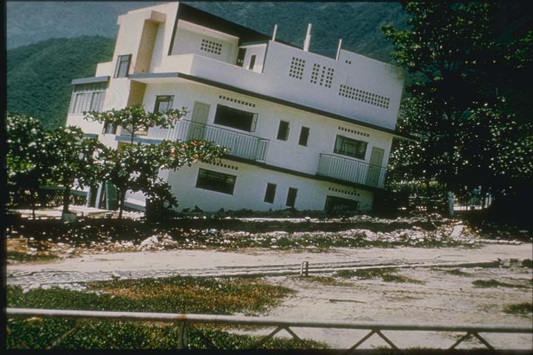
Photos
From the NCEI/WDS Natural Hazards Image Database (doi:10.7289/V5154F01). Only photos by the USGS and NOAA, which are public domain, are shown.
Sources NCEI cites
The publications NCEI lists for this record. The numbers match the “reference #” notes in its account above.
- #1039 Rothe, J.P. (1966-1973). Annual Summary of Information on Natural Disasters, UNESCO, Paris, France, 1966 (no. 1) through 1973 (no. 8), 612 p.
- #1080 Robson, G.R., L. Canales, and L. Esteva (1968). Venezuela: The Caracas Earthquake of 29 July 1967. UNESCO, Series no. 571/BMS.RD/AVS, Paris, France, 50 p.
- #1051 Munchener Ruckversicherungs-Gesellschaft (1998). World Map of Natural Hazards, Munich Federal Republic of Germany
- #45 U.S. Department of the Interior, Geological Survey and U.S. Department of Commerce, National Oceanic and Atmospheric Administration (1928-1986). United States Earthquakes, Annual publication, published 1928-1986. vol.s for 1928-1965 issued by the U.S. Coast and Geodetic Survey; volumes for 1966-1969 issued by the National Earthquake Information Center; volume for 1970 issued by the National Geophysical Data Center; volumes for 1971-1972 issued by the National Geophysical And Solar-Terrestrial Data Center; volumes for 1973-1980 published jointly by the National Oceanic and Atmospheric Administration (NOAA) and the U.S. Geological Survey; volumes for 1981-1986 published by the U.S. Geological Survey. [on shelf]
- #1064 Funvisis. El Riesgo Sismico En Venezuela, Fundacion Venezolana de Investigaciones Sismologicas (a brochure).
- #12788 Cardona, O.D., Ordaz, M., Salgado-Galvez, M.A., Barbat, A.H. and Carreno, M.L. (2018). Latin American and Caribbean earthquakes in the GEMs Earthquake Consequences Database (GEMECD). Natural hazards, 93(1), 113-125. DOI:10.1007/s11069-017-3087-9
- #10476 International Seismological Centre (2013). Final Scientific Report of the ISC-GEM Instrumental Earthquake Catalogue, ISC-GEM Global Instrumental earthquake Catalogue (1900-2021). Versions 1-12 downloaded beginning 18 March 2013. DOI: 10.31905/D808B825
- #124 Grases, Jose (1990). Terremotos Destructores del Caribe, 1502-1990. UNESCO-RELACIS, Montevideo.
- #14450 Suarez, G., and Nabelek, J. (1990). The 1967 Caracas earthquake: Fault geometry, direction of rupture propagation and seismotectonic implications. Journal of Geophysical Research, 95(B11), 17459-17474.
- #14452 Fiedler, G. (1968). Estudio sismologico de la region de Caracas con relacion al terremoto del 29 de Julio de 1967 (Terremoto del cuatricentenario): reporte y evaluaciones. Boletín Tecnico Instituto de Materiales y Modelos Estrucurales, vol. VI, Nº 23-24, 127-221, Caracas, Universidad Central de Venezuela.
Other significant earthquakes nearby
Within 200 km, the deadliest first.
- March 26, 1812, La Guaira, Venezuela
- June 24, 2026, Northern Venezuela
- April 12, 1878, Cua, Charallave, San Diego, Venezuela
- June 11, 1641, Caracas,la Guaira,cua, Venezuela
- October 29, 1900, Macuto, Venezuela
- 1906, Maiquetia, Venezuela
- January 31, 1906, Caracas, Venezuela
- February 6, 1874, Northern Venezuela
- November 12, 1916, Ocumare DE LA Costa DE Oro, Venezuela
- September 12, 2009, Carabobo, Venezuela
- September 10, 1837, Santa Teresa del Tuy,santa Lucia, Venezuela
- May 4, 1989, Falcon, Carabobo, Caracas, Venezuela
- March 7, 1879, Curiepe,san Juan DE Los Morro, Venezuela
More
Significant earthquakes of 1967The 1900sEvery quake the USGS located in 1967Recent earthquakes near hereThis day in weather history
Sources
Significant earthquakes from NOAA’s National Centers for Environmental Information, Global Historical Hazard Database, cited as NCEI/WDS, doi:10.7289/V5PN93H7. Public domain. Read 2026-10-01. NCEI earthquake 4410. The written accounts and the magnitude estimates are from the USGS earthquake catalog, event iscgem833882, matched to this record by time, place and magnitude.