M3.5 earthquake 97 km SSW of Unalaska, Alaska
A magnitude 3.5 earthquake struck 97 km SSW of Unalaska, Alaska on Mon, Jan 19, 2026, 3:16 AM AKST (12:16 UTC), 29 km (18 mi) below the surface.
A larger quake followed: M4.1 85 km E of Nikolski, Alaska. This one was a foreshock.
Map
Where this earthquake was located, with the others nearby. Select one for its page.
The earthquake
- Magnitude
- 3.5 (ml), minor
- Local time
- UTC
- 2026-01-19 12:16:06 UTC
- Depth
- 28.7 km (17.8 mi), shallow
- Epicenter
- 53.094° N, 167.190° W
- Region
- Alaska
- Strongest shaking
- II, weak shaking
- Tsunami flag
- No
- Status
- Reviewed by a seismologist
Shaking
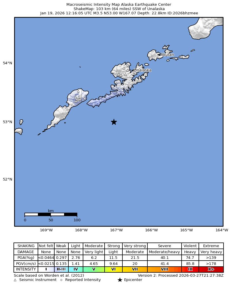
The USGS ShakeMap: shaking estimated from seismic stations and the quake’s size, on the Modified Mercalli intensity scale.
- Strongest estimated
- II, weak shaking
- Peak ground acceleration
- 0.1% of gravity
- Peak ground velocity
- 0.0 cm/s
- Map
- Automatic
Did you feel it?
No one has reported feeling this quake to the USGS.
How well it is located
Reviewed by a seismologist.
- Location uncertainty
- About 4.0 km horizontally, 11.7 km in depth
- Magnitude uncertainty
- ±0.10
- Depth from
- From location
- Station coverage gap
- 204°, poorly surrounded by stations
- Stations used
- 40
Nearest places
Distance and direction from each place to the epicenter, with its forecast.
Nearby
Within 100 km, magnitude 1.5 and up: 70 in the 60 days after this one and 49 in the 30 days before it.
After
- 2.761 km SW of Unalaska, Alaska · 254 days ago · 11 km deep · 38 km away
- 2.273 km SW of Unalaska, Alaska · 251 days ago · 12 km deep · 50 km away
- 2.3127 km S of Unalaska, Alaska · 251 days ago · 1 km deep · 57 km away
- 2.067 km ESE of Nikolski, Alaska · 251 days ago · 21 km deep · 63 km away
- 2.177 km SE of Unalaska, Alaska · 250 days ago · 23 km deep · 98 km away
- 3.8105 km S of Unalaska, Alaska · 249 days ago · 43 km deep · 30 km away
- 3.489 km SSW of Unalaska, Alaska · 245 days ago · 57 km deep · 10 km away
- 3.183 km S of Unalaska, Alaska · 243 days ago · 35 km deep · 59 km away
- 3.4123 km S of Unalaska, Alaska · 243 days ago · 20 km deep · 50 km away
- 2.938 km SSE of Unalaska, Alaska · 237 days ago · 91 km deep · 76 km away
- 2.4100 km E of Nikolski, Alaska · 236 days ago · 20 km deep · 23 km away
- 2.368 km NE of Nikolski, Alaska · 236 days ago · 76 km deep · 75 km away
- 2.370 km ESE of Nikolski, Alaska · 235 days ago · 28 km deep · 56 km away
- 2.355 km SW of Unalaska, Alaska · 235 days ago · 7 km deep · 52 km away
- 2.749 km SE of Nikolski, Alaska · 235 days ago · 35 km deep · 93 km away
- 2.573 km S of Unalaska, Alaska · 234 days ago · 35 km deep · 55 km away
- 2.036 km SE of Unalaska, Alaska · 234 days ago · 87 km deep · 89 km away
- 2.4120 km S of Unalaska, Alaska · 234 days ago · 8 km deep · 50 km away
- 2.048 km ENE of Nikolski, Alaska · 234 days ago · 93 km deep · 70 km away
- 2.15 km W of Dutch Harbor, Alaska · 230 days ago · 8 km deep · 97 km away
- 2.879 km SSE of Unalaska, Alaska · 230 days ago · 10 km deep · 71 km away
- 3.258 km ESE of Nikolski, Alaska · 230 days ago · 23 km deep · 78 km away
- 4.185 km E of Nikolski, Alaska · 229 days ago · 35 km deep · 42 km away
- 3.257 km E of Nikolski, Alaska · 228 days ago · 48 km deep · 57 km away
- 2.191 km WSW of Dutch Harbor, Alaska · 227 days ago · 96 km deep · 80 km away
- 2.223 km S of Unalaska, Alaska · 227 days ago · 94 km deep · 78 km away
- 2.282 km SW of Unalaska, Alaska · 224 days ago · 84 km deep · 40 km away
- 2.3107 km E of Nikolski, Alaska · 223 days ago · 27 km deep · 13 km away
- 2.2108 km SSW of Unalaska, Alaska · 223 days ago · 16 km deep · 15 km away
- 3.353 km SE of Unalaska, Alaska · 223 days ago · 61 km deep · 99 km away
- 2.046 km ESE of Nikolski, Alaska · 222 days ago · 35 km deep · 79 km away
- 2.3143 km ESE of Nikolski, Alaska · 221 days ago · 5 km deep · 67 km away
- 2.4104 km ESE of Nikolski, Alaska · 221 days ago · 12 km deep · 75 km away
- 2.396 km E of Nikolski, Alaska · 220 days ago · 1 km deep · 36 km away
- 1.929 km SE of Unalaska, Alaska · 220 days ago · 80 km deep · 90 km away
- 2.385 km SSW of Unalaska, Alaska · 220 days ago · 7 km deep · 14 km away
- 2.494 km S of Unalaska, Alaska · 220 days ago · 24 km deep · 47 km away
- 2.7100 km E of Nikolski, Alaska · 219 days ago · 10 km deep · 20 km away
- 2.186 km SSW of Unalaska, Alaska · 218 days ago · 13 km deep · 14 km away
- 2.359 km SSW of Unalaska, Alaska · 216 days ago · 6 km deep · 37 km away
- 2.142 km SE of Nikolski, Alaska · 216 days ago · 31 km deep · 94 km away
- 2.4100 km E of Nikolski, Alaska · 216 days ago · 43 km deep · 31 km away
- 2.447 km SE of Nikolski, Alaska · 215 days ago · 35 km deep · 85 km away
- 2.482 km SSE of Unalaska, Alaska · 215 days ago · 25 km deep · 91 km away
- 1.965 km ENE of Nikolski, Alaska · 213 days ago · 24 km deep · 51 km away
- 2.183 km SW of Unalaska, Alaska · 212 days ago · 22 km deep · 22 km away
- 1.565 km NE of Nikolski, Alaska · 212 days ago · 21 km deep · 69 km away
- 2.788 km S of Unalaska, Alaska · 210 days ago · 35 km deep · 32 km away
- 2.290 km E of Nikolski, Alaska · 209 days ago · 35 km deep · 35 km away
- 2.029 km SE of Unalaska, Alaska · 208 days ago · 81 km deep · 91 km away
- 3.149 km ESE of Nikolski, Alaska · 207 days ago · 35 km deep · 78 km away
- 2.8151 km ESE of Nikolski, Alaska · 206 days ago · 7 km deep · 76 km away
- 1.718 km SE of Unalaska, Alaska · 204 days ago · 79 km deep · 91 km away
- 2.679 km SW of Unalaska, Alaska · 203 days ago · 11 km deep · 24 km away
- 2.374 km SE of Unalaska, Alaska · 202 days ago · 31 km deep · 96 km away
- 2.2132 km ESE of Nikolski, Alaska · 201 days ago · 10 km deep · 81 km away
- 2.539 km SSW of Unalaska, Alaska · 200 days ago · 84 km deep · 59 km away
- 2.673 km SSW of Unalaska, Alaska · 199 days ago · 35 km deep · 31 km away
- 2.473 km SE of Unalaska, Alaska · 197 days ago · 35 km deep · 98 km away
- 2.4153 km ESE of Nikolski, Alaska · 196 days ago · 4 km deep · 75 km away
The first 60 of 70.
Before
- 2.924 km SE of Unalaska, Alaska · 254 days ago · 84 km deep · 96 km away
- 4.055 km SE of Unalaska, Alaska · 254 days ago · 55 km deep · 96 km away
- 2.112 km SSW of Unalaska, Alaska · 255 days ago · 95 km deep · 85 km away
- 1.994 km SSW of Unalaska, Alaska · 255 days ago · 35 km deep · 16 km away
- 3.369 km E of Nikolski, Alaska · 256 days ago · 32 km deep · 52 km away
- 3.289 km S of Unalaska, Alaska · 257 days ago · 19 km deep · 28 km away
- 2.896 km SSE of Unalaska, Alaska · 257 days ago · 8 km deep · 81 km away
- 2.562 km ENE of Nikolski, Alaska · 258 days ago · 124 km deep · 57 km away
- 2.16 km W of Dutch Harbor, Alaska · 258 days ago · 11 km deep · 95 km away
- 2.26 km WSW of Dutch Harbor, Alaska · 258 days ago · 10 km deep · 95 km away
- 1.76 km WSW of Dutch Harbor, Alaska · 258 days ago · 10 km deep · 94 km away
- 2.6107 km S of Unalaska, Alaska · 260 days ago · 12 km deep · 51 km away
- 3.391 km E of Nikolski, Alaska · 261 days ago · 35 km deep · 23 km away
- 3.662 km E of Nikolski, Alaska · 261 days ago · 43 km deep · 53 km away
- 2.854 km E of Nikolski, Alaska · 263 days ago · 35 km deep · 62 km away
- 2.882 km SE of Nikolski, Alaska · 265 days ago · 2 km deep · 77 km away
- 4.081 km E of Nikolski, Alaska · 267 days ago · 42 km deep · 37 km away
- 3.385 km E of Nikolski, Alaska · 267 days ago · 35 km deep · 43 km away
- 2.869 km SSE of Unalaska, Alaska · 268 days ago · 26 km deep · 77 km away
- 2.06 km W of Unalaska, Alaska · 269 days ago · 12 km deep · 93 km away
Earthquakes todayAlaska earthquakesLive radar here
Sources
From the USGS Earthquake Hazards Program and its partner networks, event us7000s894 (also filed as ak2026bhzmee). Read Wed, Sep 30, 2026, 5:13 AM UTC.