M3.1 earthquake 12 km WSW of Stanton, Texas
A magnitude 3.1 earthquake struck 12 km WSW of Stanton, Texas on Mon, Jun 22, 2026, 6:52 PM CDT (23:52 UTC), 9 km (6 mi) below the surface.
A larger quake followed: M3.9 23 km NW of Westbrook, Texas. This one was a foreshock.
Map
Where this earthquake was located, with the others nearby. Select one for its page.
The earthquake
- Magnitude
- 3.1 (ml), minor
- Local time
- UTC
- 2026-06-22 23:52:56 UTC
- Depth
- 8.9 km (5.5 mi), shallow
- Epicenter
- 32.103° N, 101.922° W
- Region
- Texas
- Felt reports
- 5
- Tsunami flag
- No
- Status
- Reviewed by a seismologist
Did you feel it?
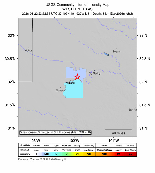
5 people reported to the USGS what they felt; the strongest reported shaking was III, weak shaking.
How well it is located
Reviewed by a seismologist.
- Location uncertainty
- About 0.2 km horizontally, 0.6 km in depth
- Magnitude uncertainty
- ±0.20
- Station coverage gap
- 35°
- Stations used
- 50
Nearest places
Distance and direction from each place to the epicenter, with its forecast.
Nearby
Within 100 km, magnitude 1.5 and up: 120 in the 60 days after this one and 74 in the 30 days before it.
After
- 2.312 km WSW of Stanton, Texas · 97 days ago · 9 km deep · 0 km away
- 1.712 km WSW of Stanton, Texas · 97 days ago · 9 km deep · 0 km away
- 1.734 km SSW of Los Ybanez, Texas · 96 days ago · 9 km deep · 41 km away
- 1.823 km NW of Westbrook, Texas · 96 days ago · 4 km deep · 82 km away
- 1.513 km WSW of Stanton, Texas · 96 days ago · 9 km deep · 1 km away
- 2.323 km NW of Westbrook, Texas · 96 days ago · 7 km deep · 82 km away
- 3.112 km WSW of Stanton, Texas · 96 days ago · 9 km deep · 0 km away · felt by 9
- 1.711 km WSW of Stanton, Texas · 95 days ago · 9 km deep · 1 km away
- 1.57 km NNE of Westbrook, Texas · 95 days ago · 3 km deep · 96 km away
- 1.617 km SE of Ackerly, Texas · 94 days ago · 6 km deep · 44 km away
- 1.838 km ENE of McKinney Acres, Texas · 94 days ago · 9 km deep · 41 km away
- 2.012 km SSW of Ackerly, Texas · 93 days ago · 9 km deep · 39 km away
- 2.033 km E of McKinney Acres, Texas · 92 days ago · 9 km deep · 37 km away
- 1.626 km N of Sterling City, Texas · 90 days ago · 5 km deep · 85 km away
- 1.510 km S of Forsan, Texas · 90 days ago · 9 km deep · 53 km away
- 1.823 km W of Garden City, Texas · 89 days ago · 8 km deep · 34 km away
- 1.511 km W of Forsan, Texas · 89 days ago · 10 km deep · 41 km away
- 1.919 km NW of Westbrook, Texas · 89 days ago · 5 km deep · 82 km away
- 2.912 km W of Stanton, Texas · 88 days ago · 7 km deep · 2 km away · felt by 5
- 1.716 km SSE of Westbrook, Texas · 88 days ago · 6 km deep · 91 km away
- 2.610 km WSW of Stanton, Texas · 87 days ago · 10 km deep · 2 km away
- 2.48 km SE of Gardendale, Texas · 87 days ago · 8 km deep · 40 km away
- 1.729 km WSW of Ackerly, Texas · 87 days ago · 9 km deep · 40 km away
- 2.836 km SSW of Los Ybanez, Texas · 86 days ago · 7 km deep · 41 km away
- 1.823 km NW of Westbrook, Texas · 85 days ago · 7 km deep · 82 km away
- 1.64 km E of Coahoma, Texas · 85 days ago · 6 km deep · 66 km away
- 1.517 km SSE of Westbrook, Texas · 85 days ago · 7 km deep · 91 km away
- 2.416 km N of Midland, Texas · 84 days ago · 7 km deep · 15 km away
- 1.536 km SSW of Los Ybanez, Texas · 83 days ago · 7 km deep · 41 km away
- 2.428 km WSW of Ackerly, Texas · 83 days ago · 10 km deep · 36 km away
- 1.916 km NW of Stanton, Texas · 83 days ago · 8 km deep · 15 km away
- 1.538 km SSW of Los Ybanez, Texas · 82 days ago · 6 km deep · 41 km away
- 2.016 km W of Stanton, Texas · 82 days ago · 9 km deep · 3 km away
- 1.516 km W of Stanton, Texas · 82 days ago · 7 km deep · 3 km away
- 1.616 km SE of Stanton, Texas · 81 days ago · 9 km deep · 24 km away
- 2.010 km WSW of Stanton, Texas · 79 days ago · 9 km deep · 3 km away
- 1.833 km WSW of Ackerly, Texas · 79 days ago · 9 km deep · 36 km away
- 1.525 km N of Coahoma, Texas · 78 days ago · 8 km deep · 72 km away
- 2.311 km SSW of Forsan, Texas · 77 days ago · 9 km deep · 50 km away
- 1.735 km SSW of Los Ybanez, Texas · 77 days ago · 9 km deep · 42 km away
- 1.636 km SSW of Los Ybanez, Texas · 76 days ago · 9 km deep · 41 km away
- 1.76 km WSW of Westbrook, Texas · 74 days ago · 9 km deep · 84 km away
- 1.920 km NW of Westbrook, Texas · 74 days ago · 8 km deep · 81 km away
- 1.714 km SSE of Stanton, Texas · 73 days ago · 8 km deep · 20 km away
- 3.324 km SW of Garden City, Texas · 73 days ago · 7 km deep · 48 km away · felt by 1
- 2.325 km SW of Garden City, Texas · 72 days ago · 7 km deep · 48 km away
- 1.613 km WSW of Stanton, Texas · 72 days ago · 8 km deep · 1 km away
- 1.624 km SW of Garden City, Texas · 72 days ago · 8 km deep · 48 km away
- 1.720 km NW of Stanton, Texas · 72 days ago · 8 km deep · 16 km away
- 1.517 km SSE of Westbrook, Texas · 71 days ago · 9 km deep · 90 km away
- 2.024 km SW of Garden City, Texas · 71 days ago · 8 km deep · 47 km away
- 2.96 km WSW of Westbrook, Texas · 70 days ago · 8 km deep · 84 km away
- 1.618 km NW of Midland, Texas · 70 days ago · 7 km deep · 26 km away
- 1.519 km NNW of Goldsmith, Texas · 70 days ago · 6 km deep · 73 km away
- 1.919 km NNW of Goldsmith, Texas · 70 days ago · 8 km deep · 73 km away
- 1.519 km NNW of Goldsmith, Texas · 70 days ago · 4 km deep · 73 km away
- 1.56 km WNW of Westbrook, Texas · 69 days ago · 9 km deep · 86 km away
- 2.012 km WSW of Stanton, Texas · 69 days ago · 9 km deep · 0 km away
- 1.617 km NNW of Stanton, Texas · 69 days ago · 8 km deep · 19 km away
- 2.524 km SW of Garden City, Texas · 67 days ago · 7 km deep · 48 km away
The first 60 of 120.
Before
- 1.731 km WSW of Ackerly, Texas · 97 days ago · 8 km deep · 38 km away
- 1.731 km WSW of Ackerly, Texas · 97 days ago · 9 km deep · 37 km away
- 1.831 km WSW of Ackerly, Texas · 97 days ago · 8 km deep · 38 km away
- 2.431 km WSW of Ackerly, Texas · 97 days ago · 8 km deep · 38 km away
- 2.131 km WSW of Ackerly, Texas · 97 days ago · 9 km deep · 39 km away
- 2.215 km SE of Coahoma, Texas · 98 days ago · 8 km deep · 69 km away
- 1.636 km NW of Stanton, Texas · 98 days ago · 7 km deep · 31 km away
- 1.624 km SSW of Westbrook, Texas · 98 days ago · 7 km deep · 79 km away
- 1.68 km NNW of Forsan, Texas · 99 days ago · 8 km deep · 51 km away
- 1.519 km NW of Westbrook, Texas · 99 days ago · 6 km deep · 82 km away
- 2.118 km NW of Stanton, Texas · 100 days ago · 8 km deep · 17 km away
- 1.718 km NW of Stanton, Texas · 100 days ago · 8 km deep · 17 km away
- 1.69 km NNE of Midland, Texas · 100 days ago · 9 km deep · 12 km away
- 2.320 km SE of Midland, Texas · 103 days ago · 6 km deep · 25 km away
- 1.520 km SE of Midland, Texas · 103 days ago · 7 km deep · 25 km away
- 2.427 km SSW of Los Ybanez, Texas · 105 days ago · 8 km deep · 43 km away
- 1.624 km E of Forsan, Texas · 105 days ago · 3 km deep · 77 km away
- 2.016 km NE of Gardendale, Texas · 106 days ago · 9 km deep · 30 km away
- 1.615 km NNE of Midland, Texas · 106 days ago · 9 km deep · 10 km away
- 1.521 km E of Forsan, Texas · 108 days ago · 7 km deep · 74 km away
Earthquakes todayTexas earthquakesLive radar here
Sources
From the USGS Earthquake Hazards Program and its partner networks, event tx2026mfohyh (also filed as us6000t7i8). Read Sun, Sep 27, 2026, 7:53 PM UTC.