M5.2 earthquake 105 km SSE of False Pass, Alaska
A magnitude 5.2 earthquake struck 105 km SSE of False Pass, Alaska on Tue, Jul 14, 2026, 4:12 AM AKDT (12:12 UTC), 35 km (22 mi) below the surface.
A larger quake followed: M5.4 93 km SE of False Pass, Alaska. This one was a foreshock.
Map
Where this earthquake was located, with the others nearby. Select one for its page.
The earthquake
- Magnitude
- 5.2 (mww), moderate
- Local time
- UTC
- 2026-07-14 12:12:18 UTC
- Depth
- 35.5 km (22.0 mi), shallow
- Epicenter
- 54.062° N, 162.530° W
- Region
- Alaska
- Felt reports
- 6
- Strongest shaking
- IV, light shaking
- Tsunami flag
- No
- Status
- Reviewed by a seismologist
Shaking
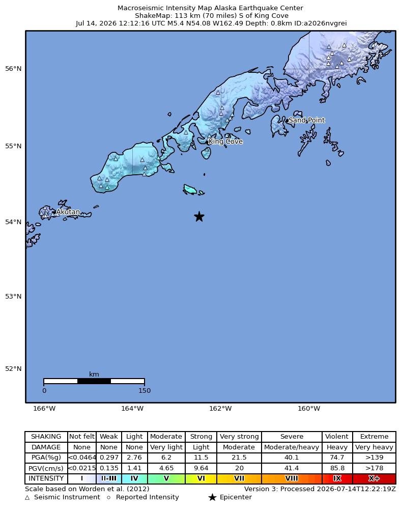
The USGS ShakeMap: shaking estimated from seismic stations and the quake’s size, on the Modified Mercalli intensity scale.
- Strongest estimated
- IV, light shaking
- Peak ground acceleration
- 3.6% of gravity
- Peak ground velocity
- 2.2 cm/s
- Map
- Automatic
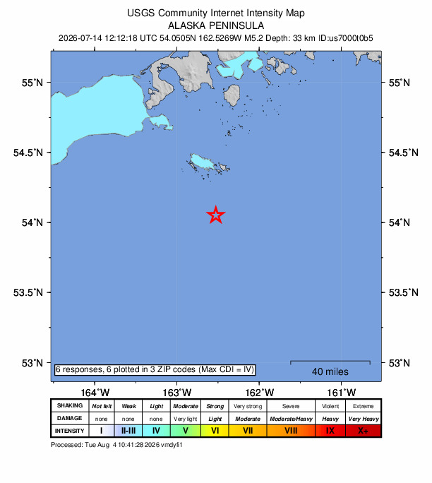
Did you feel it?
6 people reported to the USGS what they felt; the strongest reported shaking was IV, light shaking.
Aftershock forecast
The chance of at least one aftershock this large or larger, from the USGS operational aftershock forecast, issued Tue, Sep 22, 2026, 12:12 PM UTC. The USGS updates it as the sequence unfolds.
| Within | M3+ | M4+ | M5+ | M6+ | M7+ |
|---|---|---|---|---|---|
| 1 day | 1% | Under 1% | Under 1% | Under 1% | Under 1% |
| 1 week | 9% | Under 1% | Under 1% | Under 1% | Under 1% |
| 1 month | 28% | 4% | Under 1% | Under 1% | Under 1% |
| 1 year | 76% | 18% | 2% | Under 1% | Under 1% |
In the coming week the USGS expects about 0 aftershocks of magnitude 3 or more, and most likely between 0 and 1.
Fault motion and ground failure
How the rock slipped, from the moment tensor, and the USGS estimate of landslides and liquefaction.
- Faulting
- Reverse (thrust)
- Moment magnitude
- 5.2 Mww
- Nodal plane 1
- Strike 59°, dip 59°, rake 83°
- Nodal plane 2
- Strike 252°, dip 31°, rake 102°
How well it is located
Reviewed by a seismologist.
- Location uncertainty
- About 5.0 km horizontally, 5.6 km in depth
- Magnitude uncertainty
- ±0.06
- Depth from
- From location
- Station coverage gap
- 131°
- Stations used
- 267
Nearest places
Distance and direction from each place to the epicenter, with its forecast.
Nearby
Within 100 km, magnitude 2.2 and up: 128 in the 60 days after this one and 44 in the 30 days before it.
After
- 3.190 km SE of False Pass, Alaska · 77 days ago · 35 km deep · 15 km away
- 3.288 km SE of False Pass, Alaska · 77 days ago · 35 km deep · 17 km away
- 2.8114 km SSW of False Pass, Alaska · 77 days ago · 21 km deep · 89 km away
- 2.8106 km SE of False Pass, Alaska · 77 days ago · 35 km deep · 9 km away
- 2.5112 km SSW of False Pass, Alaska · 77 days ago · 28 km deep · 91 km away
- 4.393 km SE of False Pass, Alaska · 77 days ago · 42 km deep · 12 km away · felt by 2
- 5.493 km SE of False Pass, Alaska · 76 days ago · 49 km deep · 12 km away · felt by 7
- 3.3106 km SE of False Pass, Alaska · 76 days ago · 10 km deep · 6 km away
- 2.7103 km SE of False Pass, Alaska · 76 days ago · 9 km deep · 9 km away
- 2.798 km SE of False Pass, Alaska · 76 days ago · 10 km deep · 10 km away
- 2.6100 km SE of False Pass, Alaska · 76 days ago · 8 km deep · 11 km away
- 3.799 km SE of False Pass, Alaska · 76 days ago · 17 km deep · 12 km away
- 2.598 km SE of False Pass, Alaska · 76 days ago · 11 km deep · 9 km away
- 2.699 km SE of False Pass, Alaska · 76 days ago · 11 km deep · 8 km away
- 2.894 km SSE of King Cove, Alaska · 75 days ago · 4 km deep · 70 km away
- 2.9149 km S of False Pass, Alaska · 75 days ago · 35 km deep · 86 km away
- 2.335 km S of False Pass, Alaska · 74 days ago · 6 km deep · 77 km away
- 2.580 km SE of King Cove, Alaska · 74 days ago · 35 km deep · 87 km away
- 2.5124 km S of False Pass, Alaska · 74 days ago · 35 km deep · 67 km away
- 2.6126 km S of False Pass, Alaska · 74 days ago · 11 km deep · 64 km away
- 2.691 km SSE of King Cove, Alaska · 72 days ago · 6 km deep · 74 km away
- 2.993 km SSE of King Cove, Alaska · 72 days ago · 35 km deep · 68 km away
- 3.291 km SE of False Pass, Alaska · 72 days ago · 35 km deep · 15 km away
- 2.742 km SSE of King Cove, Alaska · 71 days ago · 81 km deep · 84 km away
- 2.274 km SE of King Cove, Alaska · 69 days ago · 27 km deep · 98 km away
- 2.3106 km SE of False Pass, Alaska · 67 days ago · 11 km deep · 8 km away
- 2.276 km S of King Cove, Alaska · 67 days ago · 29 km deep · 36 km away
- 2.2111 km S of False Pass, Alaska · 67 days ago · 28 km deep · 82 km away
- 3.336 km SE of King Cove, Alaska · 65 days ago · 71 km deep · 98 km away
- 2.479 km SE of King Cove, Alaska · 64 days ago · 2 km deep · 79 km away
- 2.465 km SE of False Pass, Alaska · 63 days ago · 51 km deep · 40 km away
- 2.9142 km S of False Pass, Alaska · 63 days ago · 10 km deep · 71 km away
- 2.299 km SSE of False Pass, Alaska · 62 days ago · 11 km deep · 17 km away
- 2.293 km SE of King Cove, Alaska · 62 days ago · 10 km deep · 79 km away
- 2.3100 km SE of False Pass, Alaska · 62 days ago · 8 km deep · 10 km away
- 2.587 km SE of King Cove, Alaska · 62 days ago · 18 km deep · 98 km away
- 2.580 km SSE of False Pass, Alaska · 60 days ago · 29 km deep · 30 km away
- 3.490 km SSE of King Cove, Alaska · 60 days ago · 35 km deep · 73 km away
- 2.5110 km S of False Pass, Alaska · 59 days ago · 35 km deep · 66 km away
- 2.8149 km S of False Pass, Alaska · 58 days ago · 10 km deep · 77 km away
- 2.8148 km S of False Pass, Alaska · 58 days ago · 10 km deep · 76 km away
- 2.366 km SE of King Cove, Alaska · 58 days ago · 17 km deep · 83 km away
- 2.3102 km SSW of False Pass, Alaska · 58 days ago · 28 km deep · 81 km away
- 2.624 km SE of False Pass, Alaska · 57 days ago · 5 km deep · 82 km away
- 2.736 km SE of False Pass, Alaska · 56 days ago · 7 km deep · 71 km away
- 2.970 km SE of King Cove, Alaska · 56 days ago · 35 km deep · 95 km away
- 2.9148 km S of False Pass, Alaska · 56 days ago · 22 km deep · 85 km away
- 2.5107 km S of False Pass, Alaska · 56 days ago · 35 km deep · 66 km away
- 2.2107 km SSE of King Cove, Alaska · 55 days ago · 5 km deep · 75 km away
- 2.330 km SSW of False Pass, Alaska · 55 days ago · 4 km deep · 87 km away
- 2.7112 km SSW of False Pass, Alaska · 54 days ago · 17 km deep · 97 km away
- 2.5123 km SSW of False Pass, Alaska · 54 days ago · 19 km deep · 93 km away
- 2.4109 km SSE of King Cove, Alaska · 54 days ago · 5 km deep · 78 km away
- 2.349 km SSW of King Cove, Alaska · 54 days ago · 12 km deep · 65 km away
- 2.9106 km SSE of King Cove, Alaska · 54 days ago · 9 km deep · 68 km away
- 2.587 km SE of False Pass, Alaska · 54 days ago · 10 km deep · 19 km away
- 3.5107 km SSW of False Pass, Alaska · 53 days ago · 31 km deep · 97 km away
- 2.298 km SSE of King Cove, Alaska · 53 days ago · 3 km deep · 74 km away
- 2.456 km SSE of King Cove, Alaska · 52 days ago · 73 km deep · 74 km away
- 2.5101 km SSE of False Pass, Alaska · 51 days ago · 35 km deep · 27 km away
The first 60 of 128.
Before
- 2.7150 km S of False Pass, Alaska · 77 days ago · 7 km deep · 95 km away
- 3.190 km SE of False Pass, Alaska · 79 days ago · 35 km deep · 15 km away
- 2.684 km S of False Pass, Alaska · 80 days ago · 35 km deep · 51 km away
- 2.493 km S of False Pass, Alaska · 80 days ago · 15 km deep · 47 km away
- 2.892 km SSE of King Cove, Alaska · 80 days ago · 35 km deep · 60 km away
- 2.588 km SSE of King Cove, Alaska · 81 days ago · 5 km deep · 68 km away
- 2.664 km SSW of False Pass, Alaska · 83 days ago · 61 km deep · 84 km away
- 2.9126 km SSE of King Cove, Alaska · 83 days ago · 10 km deep · 49 km away
- 2.586 km SE of False Pass, Alaska · 84 days ago · 30 km deep · 21 km away
- 2.5116 km SE of King Cove, Alaska · 84 days ago · 35 km deep · 94 km away
- 2.285 km SSE of King Cove, Alaska · 86 days ago · 8 km deep · 74 km away
- 2.8142 km S of False Pass, Alaska · 87 days ago · 35 km deep · 84 km away
- 2.273 km SSE of False Pass, Alaska · 87 days ago · 23 km deep · 32 km away
- 2.7147 km S of False Pass, Alaska · 87 days ago · 35 km deep · 95 km away
- 2.244 km SSE of False Pass, Alaska · 87 days ago · 7 km deep · 61 km away
- 2.674 km SSW of False Pass, Alaska · 88 days ago · 95 km deep · 76 km away
- 2.4113 km S of False Pass, Alaska · 89 days ago · 11 km deep · 65 km away
- 2.642 km SSE of False Pass, Alaska · 89 days ago · 12 km deep · 64 km away
- 2.746 km SSE of False Pass, Alaska · 89 days ago · 7 km deep · 60 km away
- 2.397 km S of False Pass, Alaska · 89 days ago · 27 km deep · 76 km away
Earthquakes todayAlaska earthquakesLive radar here
Sources
From the USGS Earthquake Hazards Program and its partner networks, event us7000t0b5 (also filed as atti5z8g, aka2026nvgrei, usauto7000t0b5). Read Tue, Sep 29, 2026, 4:54 AM UTC.