M5.5 earthquake 88 km SE of Akutan, Alaska
A magnitude 5.5 earthquake struck 88 km SE of Akutan, Alaska on Sat, Apr 25, 2026, 12:05 AM AKDT (08:05 UTC), 24 km (15 mi) below the surface.
Map
Where this earthquake was located, with the others nearby. Select one for its page.
The earthquake
- Magnitude
- 5.5 (Mww, W-phase moment), moderate
- Magnitude from
- USGS National Earthquake Information Center
- Local time
- UTC
- 2026-04-25 08:05:54 UTC
- Depth
- 23.6 km (14.7 mi), shallow
- Epicenter
- 53.583° N, 164.805° W
- Region
- Alaska
- Felt reports
- 12
- Strongest shaking
- IV, light shaking
- PAGER alert
- Green
- Tsunami flag
- No
- Status
- Reviewed by a seismologist
Magnitude estimates
Different scales measure different things and differ by a few tenths. The USGS marks one as preferred, and it is the one this page uses.
| Mag. | Scale | Computed by | Notes |
|---|---|---|---|
| 5.5 | Mww, W-phase moment | USGS National Earthquake Information Center | Preferred · Reviewed · ±0.046 · 46 stations |
| 5.5 | ML, local (Richter) | Alaska Earthquake Center | Reviewed · ±0.1 · 55 stations |
| 5.5 | Mww, W-phase moment | USGS, automatic first solution | First automatic solution · Preliminary |
Shaking
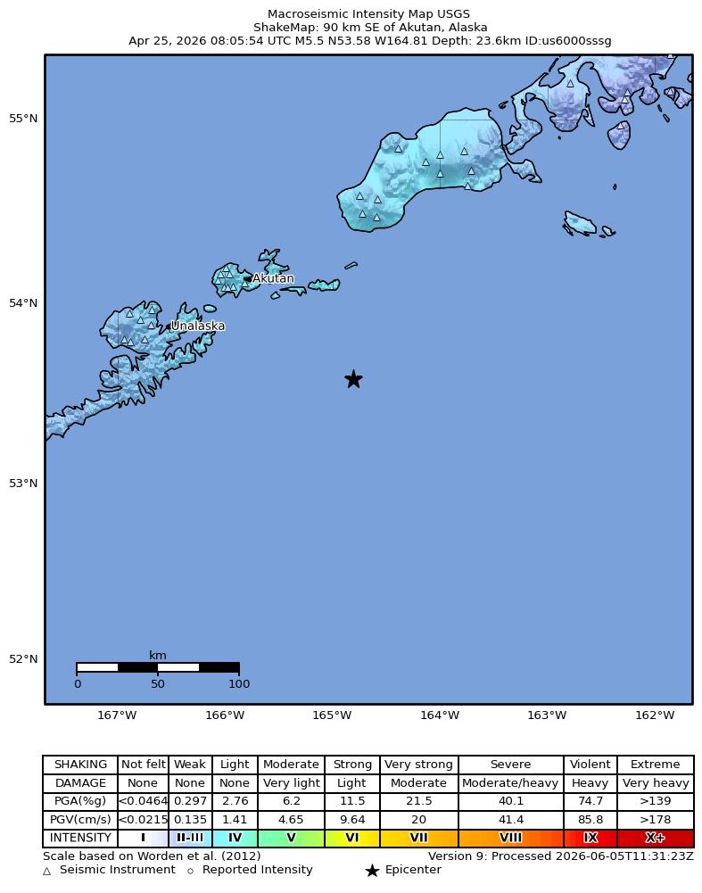
The USGS ShakeMap: shaking estimated from seismic stations and the quake’s size, on the Modified Mercalli intensity scale.
- Strongest estimated
- IV, light shaking
- Peak ground acceleration
- 2.2% of gravity
- Peak ground velocity
- 1.8 cm/s
- Map
- Automatic
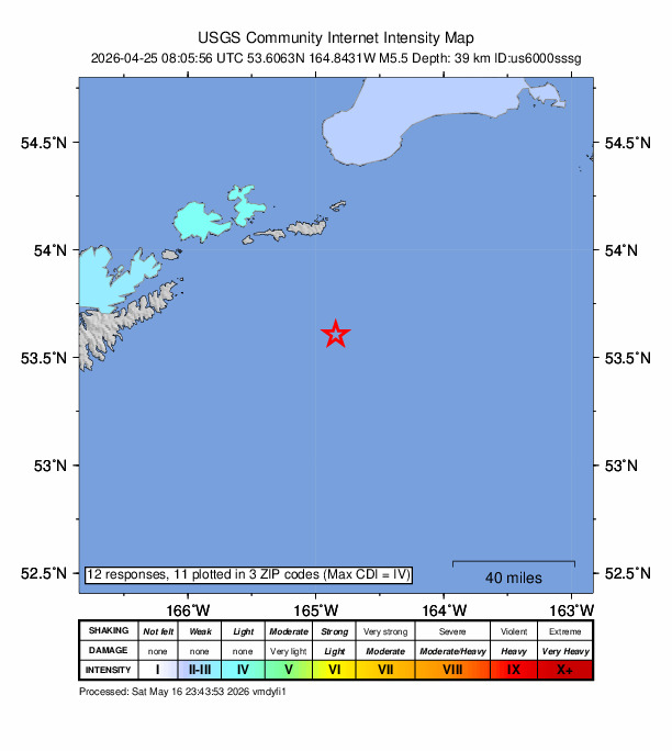
Did you feel it?
12 people reported to the USGS what they felt; the strongest reported shaking was IV, light shaking.
Estimated impact
The USGS PAGER system estimates deaths and economic losses from the shaking and the population and buildings exposed to it.
- Alert level
- Green: little or no damage or loss of life expected
| Range | Chance |
|---|---|
| Under 1 | 95% |
| 1 to 10 | 5% |
| 10 to 100 | Under 1% |
| 100 to 1,000 | Under 1% |
| 1,000 to 10,000 | Under 1% |
| 10,000 to 100,000 | Under 1% |
| 100,000 to 10,000,000 | Under 1% |
| Range, million USD | Chance |
|---|---|
| Under 1 | 90% |
| 1 to 10 | 9% |
| 10 to 100 | Under 1% |
| 100 to 1,000 | Under 1% |
| 1,000 to 10,000 | Under 1% |
| 10,000 to 100,000 | Under 1% |
| 100,000 to 10,000,000 | Under 1% |
Aftershock forecast
The chance of at least one aftershock this large or larger, from the USGS operational aftershock forecast, issued Sat, Sep 26, 2026, 8:05 AM UTC. The USGS updates it as the sequence unfolds.
| Within | M3+ | M4+ | M5+ | M6+ | M7+ |
|---|---|---|---|---|---|
| 1 day | 3% | Under 1% | Under 1% | Under 1% | Under 1% |
| 1 week | 18% | 2% | Under 1% | Under 1% | Under 1% |
| 1 month | 53% | 8% | Under 1% | Under 1% | Under 1% |
| 1 year | 99% | 43% | 6% | Under 1% | Under 1% |
In the coming week the USGS expects about 0 aftershocks of magnitude 3 or more, and most likely between 0 and 1.
Fault motion and ground failure
How the rock slipped, from the moment tensor, and the USGS estimate of landslides and liquefaction.
- Faulting
- Oblique reverse
- Moment magnitude
- 5.5 Mww
- Nodal plane 1
- Strike 291°, dip 8°, rake 142°
- Nodal plane 2
- Strike 59°, dip 85°, rake 84°
More from the USGS
Thank you Rob
This marks the final public earthquake release issued by Rob at the USGS National Earthquake Information Center. Over the course of 12 years of distinguished service on the night shift, Rob processed more than 28,000 earthquakes and analyzed over 1.2 million seismic arrivals. The unparalleled quality of the nation’s earthquake assessments is made possible through the steadfast dedication and expertise of seismologists like Rob. We extend our deepest appreciation for Rob’s exemplary public service and offer our warmest wishes for a fulfilling time in his next adventures.
From the USGS event page for us6000sssg. U.S. Geological Survey text and figures are in the public domain.
How well it is located
Reviewed by a seismologist.
- Location uncertainty
- About 4.6 km horizontally, 4.9 km in depth
- Magnitude uncertainty
- ±0.05
- Depth from
- From location
- Station coverage gap
- 63°
- Stations used
- 120
Nearest places
Distance and direction from each place to the epicenter, with its forecast.
Nearby
Within 100 km, magnitude 2.5 and up: 149 in the 60 days after this one and 34 in the 30 days before it.
After
- 3.481 km SE of Akutan, Alaska · 160 days ago · 35 km deep · 13 km away
- 2.987 km SE of Akutan, Alaska · 160 days ago · 35 km deep · 6 km away
- 2.785 km SE of Akutan, Alaska · 160 days ago · 35 km deep · 3 km away
- 2.595 km SE of Akutan, Alaska · 160 days ago · 24 km deep · 7 km away
- 2.693 km SE of Akutan, Alaska · 160 days ago · 35 km deep · 8 km away
- 3.586 km SE of Akutan, Alaska · 160 days ago · 35 km deep · 2 km away
- 3.389 km SE of Akutan, Alaska · 160 days ago · 35 km deep · 10 km away
- 2.5101 km SE of Akutan, Alaska · 160 days ago · 15 km deep · 16 km away
- 3.281 km SE of Akutan, Alaska · 160 days ago · 35 km deep · 8 km away
- 3.688 km SE of Akutan, Alaska · 160 days ago · 35 km deep · 5 km away · felt by 2
- 2.5100 km SE of Akutan, Alaska · 160 days ago · 24 km deep · 12 km away
- 2.598 km SE of Akutan, Alaska · 160 days ago · 22 km deep · 10 km away
- 2.887 km SE of Akutan, Alaska · 160 days ago · 35 km deep · 1 km away
- 2.883 km SE of Akutan, Alaska · 160 days ago · 35 km deep · 9 km away
- 3.194 km SE of Akutan, Alaska · 160 days ago · 35 km deep · 6 km away
- 2.595 km SE of Akutan, Alaska · 160 days ago · 15 km deep · 7 km away
- 2.682 km SE of Akutan, Alaska · 160 days ago · 29 km deep · 9 km away
- 2.688 km SE of Akutan, Alaska · 160 days ago · 29 km deep · 2 km away
- 3.086 km SE of Akutan, Alaska · 160 days ago · 35 km deep · 4 km away
- 2.888 km SE of Akutan, Alaska · 160 days ago · 35 km deep · 7 km away
- 3.081 km SE of Akutan, Alaska · 160 days ago · 35 km deep · 8 km away
- 3.588 km SE of Akutan, Alaska · 159 days ago · 35 km deep · 4 km away
- 2.869 km SE of Akutan, Alaska · 159 days ago · 35 km deep · 19 km away
- 2.985 km SE of Akutan, Alaska · 159 days ago · 35 km deep · 3 km away
- 2.686 km SE of Akutan, Alaska · 159 days ago · 35 km deep · 7 km away
- 2.5100 km SE of Akutan, Alaska · 159 days ago · 15 km deep · 13 km away
- 2.596 km SE of Akutan, Alaska · 159 days ago · 15 km deep · 8 km away
- 2.777 km SE of Akutan, Alaska · 159 days ago · 35 km deep · 11 km away
- 2.599 km SE of Akutan, Alaska · 159 days ago · 23 km deep · 12 km away
- 3.590 km SE of Akutan, Alaska · 159 days ago · 35 km deep · 3 km away
- 2.694 km SE of Akutan, Alaska · 159 days ago · 23 km deep · 6 km away
- 2.6101 km SE of Akutan, Alaska · 159 days ago · 18 km deep · 15 km away
- 2.5101 km SE of Akutan, Alaska · 159 days ago · 18 km deep · 13 km away
- 2.595 km SE of Akutan, Alaska · 159 days ago · 23 km deep · 8 km away
- 2.5100 km SE of Akutan, Alaska · 159 days ago · 25 km deep · 12 km away
- 2.699 km SE of Akutan, Alaska · 159 days ago · 22 km deep · 11 km away
- 2.597 km SE of Akutan, Alaska · 159 days ago · 35 km deep · 9 km away
- 2.590 km SE of Akutan, Alaska · 159 days ago · 23 km deep · 2 km away
- 2.775 km SE of Akutan, Alaska · 159 days ago · 30 km deep · 14 km away
- 2.785 km SE of Akutan, Alaska · 159 days ago · 35 km deep · 6 km away
- 2.689 km SE of Akutan, Alaska · 159 days ago · 35 km deep · 3 km away
- 2.984 km SE of Akutan, Alaska · 159 days ago · 25 km deep · 7 km away
- 2.591 km SE of Akutan, Alaska · 159 days ago · 35 km deep · 4 km away
- 3.495 km SE of Akutan, Alaska · 159 days ago · 35 km deep · 7 km away
- 2.981 km SE of Akutan, Alaska · 159 days ago · 35 km deep · 7 km away
- 2.599 km SE of Akutan, Alaska · 159 days ago · 20 km deep · 12 km away
- 2.787 km SE of Akutan, Alaska · 159 days ago · 35 km deep · 2 km away
- 2.798 km SE of Akutan, Alaska · 159 days ago · 35 km deep · 10 km away
- 3.886 km SE of Akutan, Alaska · 159 days ago · 35 km deep · 6 km away
- 3.187 km SE of Akutan, Alaska · 159 days ago · 35 km deep · 3 km away
- 4.482 km SE of Akutan, Alaska · 159 days ago · 42 km deep · 7 km away · felt by 1
- 2.787 km SE of Akutan, Alaska · 159 days ago · 51 km deep · 1 km away
- 2.996 km SE of Akutan, Alaska · 159 days ago · 29 km deep · 8 km away
- 2.8101 km SE of Akutan, Alaska · 159 days ago · 21 km deep · 13 km away
- 3.288 km SE of Akutan, Alaska · 158 days ago · 35 km deep · 0 km away
- 2.6100 km SE of Akutan, Alaska · 158 days ago · 35 km deep · 16 km away
- 2.999 km SE of Akutan, Alaska · 158 days ago · 17 km deep · 11 km away
- 2.993 km SE of Akutan, Alaska · 158 days ago · 35 km deep · 6 km away
- 3.385 km SE of Akutan, Alaska · 158 days ago · 35 km deep · 4 km away
- 2.888 km SE of Unalaska, Alaska · 158 days ago · 24 km deep · 71 km away
The first 60 of 149.
Before
- 3.083 km SE of Akutan, Alaska · 160 days ago · 10 km deep · 6 km away
- 3.0138 km SE of Akutan, Alaska · 161 days ago · 35 km deep · 50 km away
- 3.416 km ESE of Akutan, Alaska · 162 days ago · 117 km deep · 74 km away
- 2.881 km SE of Akutan, Alaska · 162 days ago · 35 km deep · 8 km away
- 2.791 km E of Akutan, Alaska · 163 days ago · 76 km deep · 63 km away
- 2.586 km SE of Akutan, Alaska · 164 days ago · 35 km deep · 2 km away
- 2.5103 km ESE of Akutan, Alaska · 166 days ago · 29 km deep · 42 km away
- 3.352 km SE of Akutan, Alaska · 167 days ago · 65 km deep · 36 km away
- 2.6149 km SE of Akutan, Alaska · 168 days ago · 66 km deep · 61 km away
- 2.6129 km SE of Akutan, Alaska · 169 days ago · 35 km deep · 41 km away
- 2.5105 km SSE of Unalaska, Alaska · 171 days ago · 35 km deep · 86 km away
- 2.590 km SSE of Akutan, Alaska · 172 days ago · 5 km deep · 32 km away
- 2.665 km SE of Unalaska, Alaska · 173 days ago · 35 km deep · 70 km away
- 2.695 km ESE of Akutan, Alaska · 173 days ago · 35 km deep · 45 km away
- 3.043 km ESE of Akutan, Alaska · 175 days ago · 76 km deep · 52 km away
- 2.586 km SSE of Unalaska, Alaska · 175 days ago · 30 km deep · 91 km away
- 2.7112 km ESE of Akutan, Alaska · 175 days ago · 35 km deep · 44 km away
- 2.9115 km ESE of Akutan, Alaska · 176 days ago · 10 km deep · 45 km away
- 2.5126 km SSE of Unalaska, Alaska · 176 days ago · 10 km deep · 98 km away
- 2.6154 km S of False Pass, Alaska · 177 days ago · 10 km deep · 76 km away
Earthquakes todayAlaska earthquakesLive radar here
Sources
From the USGS Earthquake Hazards Program and its partner networks, event us6000sssg (also filed as usauto6000sssg, aka2026ibwxbm). Read Thu, Oct 1, 2026, 9:31 PM UTC.