M5.2 earthquake 126 km S of Unalaska, Alaska
A magnitude 5.2 earthquake struck 126 km S of Unalaska, Alaska on Tue, Jan 21, 2025, 2:55 AM AKST (11:55 UTC), 10 km (6 mi) below the surface.
A larger quake followed: M5.6 86 km SSW of Unalaska, Alaska. This one was a foreshock.
Map
Where this earthquake was located, with the others nearby. Select one for its page.
The earthquake
- Magnitude
- 5.2 (mww), moderate
- Local time
- UTC
- 2025-01-21 11:55:03 UTC
- Depth
- 10.0 km (6.2 mi), shallow
- Epicenter
- 52.743° N, 166.651° W
- Region
- Alaska
- Felt reports
- 2
- Strongest shaking
- III, weak shaking
- Tsunami flag
- No
- Status
- Reviewed by a seismologist
Shaking
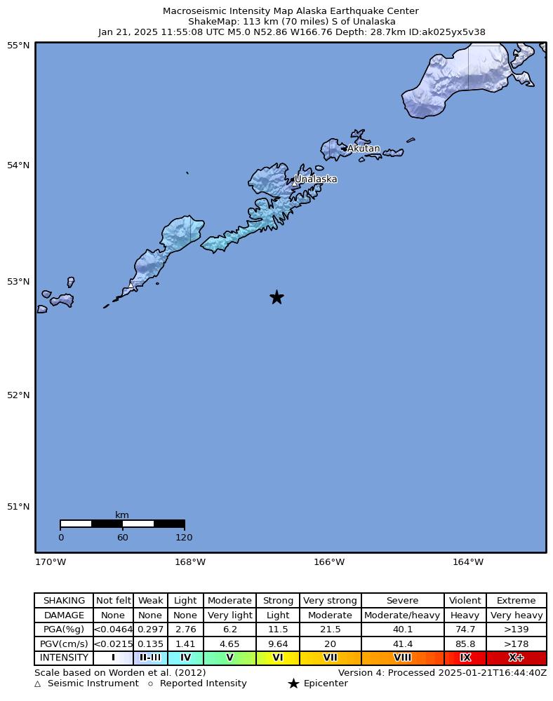
The USGS ShakeMap: shaking estimated from seismic stations and the quake’s size, on the Modified Mercalli intensity scale.
- Strongest estimated
- III, weak shaking
- Peak ground acceleration
- 0.5% of gravity
- Peak ground velocity
- 0.2 cm/s
- Map
- Automatic
Did you feel it?
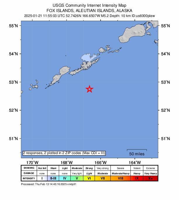
2 people reported to the USGS what they felt; the strongest reported shaking was III, weak shaking.
Aftershock forecast
The chance of at least one aftershock this large or larger, from the USGS operational aftershock forecast, issued Wed, Jan 21, 2026, 11:55 AM UTC. The USGS updates it as the sequence unfolds.
| Within | M3+ | M4+ | M5+ | M6+ | M7+ |
|---|---|---|---|---|---|
| 1 day | Under 1% | Under 1% | Under 1% | Under 1% | Under 1% |
| 1 week | 3% | Under 1% | Under 1% | Under 1% | Under 1% |
| 1 month | 12% | 1% | Under 1% | Under 1% | Under 1% |
| 1 year | 63% | 11% | 1% | Under 1% | Under 1% |
In the coming week the USGS expects about 0 aftershocks of magnitude 3 or more, and most likely between 0 and 1.
Fault motion and ground failure
How the rock slipped, from the moment tensor, and the USGS estimate of landslides and liquefaction.
- Faulting
- Reverse (thrust)
- Moment magnitude
- 5.2 Mww
- Nodal plane 1
- Strike 245°, dip 31°, rake 83°
- Nodal plane 2
- Strike 73°, dip 59°, rake 94°
How well it is located
Reviewed by a seismologist.
- Location uncertainty
- About 3.9 km horizontally, 1.8 km in depth
- Magnitude uncertainty
- ±0.06
- Depth from
- Operator assigned
- Station coverage gap
- 133°
- Stations used
- 242
Nearest places
Distance and direction from each place to the epicenter, with its forecast.
Nearby
Within 100 km, magnitude 2.2 and up: 92 in the 60 days after this one and 23 in the 30 days before it.
After
- 2.4118 km S of Unalaska, Alaska · 616 days ago · 16 km deep · 15 km away
- 2.3128 km S of Unalaska, Alaska · 616 days ago · 24 km deep · 4 km away
- 2.2120 km S of Unalaska, Alaska · 616 days ago · 19 km deep · 7 km away
- 2.7109 km S of Unalaska, Alaska · 616 days ago · 35 km deep · 19 km away
- 3.3140 km S of Unalaska, Alaska · 616 days ago · 10 km deep · 14 km away
- 3.4125 km S of Unalaska, Alaska · 616 days ago · 7 km deep · 4 km away
- 3.0106 km E of Nikolski, Alaska · 616 days ago · 35 km deep · 45 km away
- 3.4138 km S of Unalaska, Alaska · 616 days ago · 30 km deep · 13 km away
- 2.6124 km S of Unalaska, Alaska · 616 days ago · 35 km deep · 2 km away
- 2.8136 km S of Unalaska, Alaska · 616 days ago · 10 km deep · 12 km away
- 2.7129 km S of Unalaska, Alaska · 616 days ago · 25 km deep · 8 km away
- 4.4123 km S of Unalaska, Alaska · 616 days ago · 10 km deep · 2 km away
- 2.7139 km S of Unalaska, Alaska · 616 days ago · 10 km deep · 15 km away
- 2.4118 km S of Unalaska, Alaska · 616 days ago · 15 km deep · 8 km away
- 2.4126 km S of Unalaska, Alaska · 616 days ago · 13 km deep · 1 km away
- 3.5129 km S of Unalaska, Alaska · 616 days ago · 32 km deep · 5 km away
- 3.2133 km S of Unalaska, Alaska · 616 days ago · 35 km deep · 9 km away
- 2.6133 km S of Unalaska, Alaska · 616 days ago · 20 km deep · 8 km away
- 2.4130 km S of Unalaska, Alaska · 615 days ago · 18 km deep · 5 km away
- 2.6138 km S of Unalaska, Alaska · 615 days ago · 30 km deep · 12 km away
- 2.8104 km SSW of Unalaska, Alaska · 615 days ago · 35 km deep · 29 km away
- 3.2125 km S of Unalaska, Alaska · 615 days ago · 10 km deep · 10 km away
- 3.5136 km S of Unalaska, Alaska · 615 days ago · 10 km deep · 13 km away
- 2.9128 km S of Unalaska, Alaska · 615 days ago · 10 km deep · 3 km away
- 3.0122 km S of Unalaska, Alaska · 615 days ago · 10 km deep · 6 km away
- 2.4138 km S of Unalaska, Alaska · 615 days ago · 18 km deep · 14 km away
- 3.6114 km S of Unalaska, Alaska · 615 days ago · 10 km deep · 16 km away
- 2.6133 km S of Unalaska, Alaska · 614 days ago · 10 km deep · 8 km away
- 2.9132 km S of Unalaska, Alaska · 614 days ago · 10 km deep · 8 km away
- 2.4128 km S of Unalaska, Alaska · 614 days ago · 19 km deep · 2 km away
- 2.7119 km S of Unalaska, Alaska · 614 days ago · 10 km deep · 8 km away
- 2.9132 km S of Unalaska, Alaska · 614 days ago · 10 km deep · 7 km away
- 2.6136 km S of Unalaska, Alaska · 614 days ago · 10 km deep · 10 km away
- 2.874 km E of Nikolski, Alaska · 614 days ago · 35 km deep · 77 km away
- 2.4115 km S of Unalaska, Alaska · 613 days ago · 8 km deep · 17 km away
- 3.3136 km S of Unalaska, Alaska · 611 days ago · 10 km deep · 13 km away
- 5.686 km SSW of Unalaska, Alaska · 611 days ago · 59 km deep · 63 km away · felt by 44 · tsunami flag
- 3.688 km SW of Unalaska, Alaska · 611 days ago · 78 km deep · 76 km away
- 2.895 km SSW of Unalaska, Alaska · 611 days ago · 32 km deep · 53 km away
- 2.8101 km SSW of Unalaska, Alaska · 611 days ago · 32 km deep · 45 km away
- 3.3135 km S of Unalaska, Alaska · 610 days ago · 25 km deep · 9 km away
- 2.8136 km S of Unalaska, Alaska · 610 days ago · 10 km deep · 12 km away
- 3.5185 km ESE of Nikolski, Alaska · 609 days ago · 10 km deep · 76 km away
- 3.170 km SE of Nikolski, Alaska · 609 days ago · 35 km deep · 98 km away
- 3.184 km SW of Unalaska, Alaska · 609 days ago · 68 km deep · 81 km away
- 2.9109 km E of Nikolski, Alaska · 608 days ago · 35 km deep · 41 km away
- 2.2133 km S of Unalaska, Alaska · 607 days ago · 5 km deep · 8 km away
- 3.287 km SW of Unalaska, Alaska · 606 days ago · 63 km deep · 75 km away
- 2.2129 km SSW of Unalaska, Alaska · 606 days ago · 6 km deep · 18 km away
- 2.2139 km S of Unalaska, Alaska · 606 days ago · 12 km deep · 14 km away
- 2.7117 km S of Unalaska, Alaska · 606 days ago · 6 km deep · 9 km away
- 2.263 km E of Nikolski, Alaska · 606 days ago · 47 km deep · 86 km away
- 2.683 km SW of Unalaska, Alaska · 606 days ago · 79 km deep · 89 km away
- 4.484 km SW of Unalaska, Alaska · 605 days ago · 78 km deep · 84 km away · felt by 1
- 2.7102 km E of Nikolski, Alaska · 603 days ago · 35 km deep · 54 km away
- 2.695 km SSW of Unalaska, Alaska · 602 days ago · 35 km deep · 52 km away
- 3.291 km SW of Unalaska, Alaska · 601 days ago · 71 km deep · 87 km away
- 2.5132 km S of Unalaska, Alaska · 601 days ago · 10 km deep · 11 km away
- 2.6143 km ESE of Nikolski, Alaska · 600 days ago · 9 km deep · 31 km away
- 2.2127 km ESE of Nikolski, Alaska · 595 days ago · 13 km deep · 41 km away
The first 60 of 92.
Before
- 2.7114 km ESE of Nikolski, Alaska · 616 days ago · 10 km deep · 38 km away
- 2.7108 km E of Nikolski, Alaska · 616 days ago · 35 km deep · 42 km away
- 2.5162 km SSE of Unalaska, Alaska · 619 days ago · 10 km deep · 91 km away
- 2.268 km SE of Nikolski, Alaska · 619 days ago · 2 km deep · 100 km away
- 2.4136 km ESE of Nikolski, Alaska · 619 days ago · 13 km deep · 29 km away
- 2.770 km SE of Unalaska, Alaska · 620 days ago · 35 km deep · 96 km away
- 2.254 km SW of Unalaska, Alaska · 621 days ago · 24 km deep · 85 km away
- 4.282 km SSW of Unalaska, Alaska · 623 days ago · 43 km deep · 48 km away
- 2.596 km E of Nikolski, Alaska · 623 days ago · 35 km deep · 67 km away
- 2.266 km ESE of Nikolski, Alaska · 625 days ago · 35 km deep · 94 km away
- 2.730 km SSW of Unalaska, Alaska · 625 days ago · 93 km deep · 96 km away
- 2.585 km SSW of Unalaska, Alaska · 626 days ago · 35 km deep · 53 km away
- 2.2105 km SE of Unalaska, Alaska · 629 days ago · 25 km deep · 86 km away
- 2.4194 km S of Unalaska, Alaska · 629 days ago · 24 km deep · 76 km away
- 2.991 km ENE of Nikolski, Alaska · 636 days ago · 108 km deep · 96 km away
- 2.3125 km SE of Unalaska, Alaska · 637 days ago · 29 km deep · 90 km away
- 2.4183 km SSE of Unalaska, Alaska · 640 days ago · 10 km deep · 97 km away
- 3.5106 km ESE of Nikolski, Alaska · 640 days ago · 9 km deep · 68 km away
- 2.979 km S of Unalaska, Alaska · 640 days ago · 35 km deep · 49 km away
- 2.8131 km ESE of Nikolski, Alaska · 641 days ago · 10 km deep · 26 km away
Earthquakes todayAlaska earthquakesLive radar here
Sources
From the USGS Earthquake Hazards Program and its partner networks, event us6000plew (also filed as usauto6000plew, ak025yx5v38). Read Tue, Sep 29, 2026, 12:10 PM UTC.