M5.1 earthquake 86 km SSE of Sand Point, Alaska
A magnitude 5.1 earthquake struck 86 km SSE of Sand Point, Alaska on Wed, Jul 16, 2025, 5:12 PM AKDT (01:12 UTC), 36 km (23 mi) below the surface.
A larger quake followed: M6.2 91 km SSE of Sand Point, Alaska. This one was a foreshock.
Map
Where this earthquake was located, with the others nearby. Select one for its page.
The earthquake
- Magnitude
- 5.1 (Mwr, regional moment), moderate
- Magnitude from
- USGS National Earthquake Information Center
- Local time
- UTC
- 2025-07-17 01:12:21 UTC
- Depth
- 36.5 km (22.7 mi), shallow
- Epicenter
- 54.575° N, 160.222° W
- Region
- Alaska
- Strongest shaking
- IV, light shaking
- Tsunami flag
- Yes: a large quake in an oceanic region
- Status
- Reviewed by a seismologist
Magnitude estimates
Different scales measure different things and differ by a few tenths. The USGS marks one as preferred, and it is the one this page uses.
| Mag. | Scale | Computed by | Notes |
|---|---|---|---|
| 5.1 | Mwr, regional moment | USGS National Earthquake Information Center | Preferred · Reviewed · ±0.043 · 53 stations |
| 5.1 | Mwr, regional moment | Alaska Earthquake Center | Preliminary |
| 5.0 | ML, local (Richter) | NOAA National Tsunami Warning Center | Reviewed · 16 stations |
Tsunami
The USGS flags a quake this large in an oceanic region. The flag does not mean a tsunami happened; the tsunami warning centers decide that, and their messages are below when they issued any.
Current tsunami warnings: tsunami.gov. Warnings in force in the US also appear on our alerts pages.
Shaking
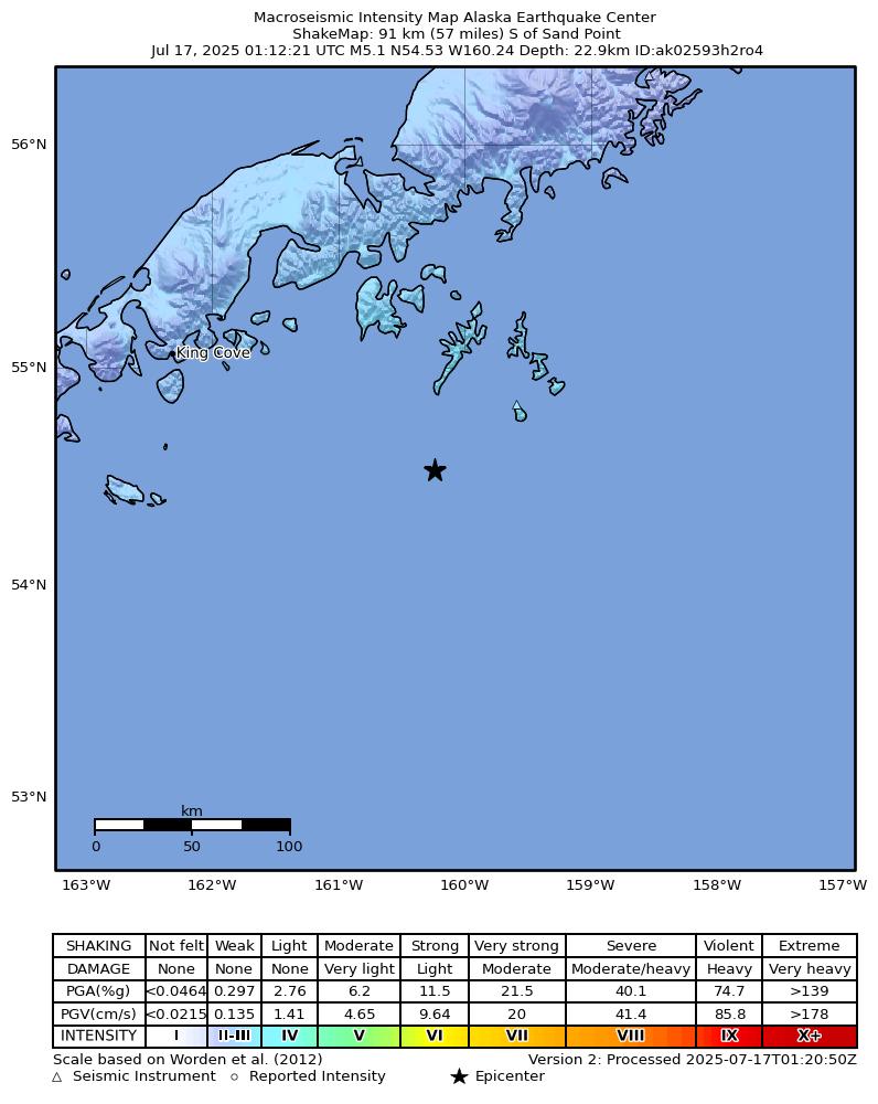
The USGS ShakeMap: shaking estimated from seismic stations and the quake’s size, on the Modified Mercalli intensity scale.
- Strongest estimated
- IV, light shaking
- Peak ground acceleration
- 1.4% of gravity
- Peak ground velocity
- 1.0 cm/s
- Map
- Automatic
Did you feel it?
No one has reported feeling this quake to the USGS.
Fault motion and ground failure
How the rock slipped, from the moment tensor, and the USGS estimate of landslides and liquefaction.
- Faulting
- Strike-slip
- Moment magnitude
- 5.1 Mwr
- Nodal plane 1
- Strike 89°, dip 52°, rake 29°
- Nodal plane 2
- Strike 340°, dip 68°, rake 138°
How well it is located
Reviewed by a seismologist.
- Location uncertainty
- About 2.7 km horizontally, 5.6 km in depth
- Magnitude uncertainty
- ±0.04
- Depth from
- From location
- Station coverage gap
- 122°
- Stations used
- 117
Nearest places
Distance and direction from each place to the epicenter, with its forecast.
Nearby
Within 100 km, magnitude 2.1 and up: at least 200 in the 60 days after this one and at least 200 in the 30 days before it.
After
- 2.389 km S of Sand Point, Alaska · 442 days ago · 26 km deep · 17 km away
- 3.584 km S of Sand Point, Alaska · 442 days ago · 19 km deep · 10 km away
- 3.389 km S of Sand Point, Alaska · 442 days ago · 18 km deep · 9 km away
- 2.491 km SSE of Sand Point, Alaska · 442 days ago · 26 km deep · 5 km away
- 2.480 km S of Sand Point, Alaska · 442 days ago · 21 km deep · 11 km away
- 2.988 km S of Sand Point, Alaska · 442 days ago · 14 km deep · 23 km away
- 3.7100 km SSE of Sand Point, Alaska · 442 days ago · 38 km deep · 14 km away
- 2.986 km S of Sand Point, Alaska · 442 days ago · 14 km deep · 10 km away
- 2.9102 km S of Sand Point, Alaska · 442 days ago · 35 km deep · 18 km away
- 2.5137 km SSE of Sand Point, Alaska · 442 days ago · 10 km deep · 51 km away
- 3.197 km SSE of Sand Point, Alaska · 442 days ago · 10 km deep · 15 km away
- 2.283 km SSE of Sand Point, Alaska · 442 days ago · 19 km deep · 15 km away
- 2.290 km S of Sand Point, Alaska · 442 days ago · 18 km deep · 11 km away
- 2.385 km SSE of Sand Point, Alaska · 442 days ago · 9 km deep · 14 km away
- 3.1109 km SSE of Sand Point, Alaska · 442 days ago · 35 km deep · 25 km away
- 3.191 km SSE of Sand Point, Alaska · 442 days ago · 15 km deep · 5 km away
- 3.6108 km SSE of Sand Point, Alaska · 442 days ago · 10 km deep · 32 km away
- 2.6114 km SSE of Sand Point, Alaska · 442 days ago · 35 km deep · 28 km away
- 2.997 km S of Sand Point, Alaska · 442 days ago · 18 km deep · 19 km away
- 2.184 km S of Sand Point, Alaska · 442 days ago · 18 km deep · 17 km away
- 3.183 km S of Sand Point, Alaska · 442 days ago · 14 km deep · 5 km away
- 2.5112 km S of Sand Point, Alaska · 442 days ago · 31 km deep · 45 km away
- 3.1100 km SSE of Sand Point, Alaska · 442 days ago · 23 km deep · 36 km away
- 3.087 km SSE of Sand Point, Alaska · 442 days ago · 19 km deep · 14 km away
- 2.278 km SSE of Sand Point, Alaska · 442 days ago · 15 km deep · 19 km away
- 2.386 km SSE of Sand Point, Alaska · 442 days ago · 16 km deep · 2 km away
- 3.178 km S of Sand Point, Alaska · 441 days ago · 8 km deep · 24 km away
- 2.483 km S of Sand Point, Alaska · 441 days ago · 15 km deep · 17 km away
- 5.285 km SSE of Sand Point, Alaska · 441 days ago · 35 km deep · 13 km away · felt by 1 · tsunami flag
- 3.175 km SSE of Sand Point, Alaska · 441 days ago · 35 km deep · 16 km away
- 3.5107 km SSE of Sand Point, Alaska · 441 days ago · 35 km deep · 25 km away
- 2.287 km SSE of Sand Point, Alaska · 441 days ago · 13 km deep · 14 km away
- 3.289 km SSE of Sand Point, Alaska · 441 days ago · 35 km deep · 11 km away
- 3.092 km S of Sand Point, Alaska · 441 days ago · 15 km deep · 9 km away
- 2.881 km S of Sand Point, Alaska · 441 days ago · 10 km deep · 8 km away
- 2.982 km S of Sand Point, Alaska · 441 days ago · 15 km deep · 9 km away
- 2.198 km SSE of Sand Point, Alaska · 441 days ago · 24 km deep · 31 km away
- 2.289 km SSE of Sand Point, Alaska · 441 days ago · 19 km deep · 12 km away
- 3.199 km SSE of Sand Point, Alaska · 441 days ago · 20 km deep · 32 km away
- 2.282 km S of Sand Point, Alaska · 441 days ago · 18 km deep · 7 km away
- 2.588 km SSE of Sand Point, Alaska · 441 days ago · 22 km deep · 3 km away
- 2.996 km S of Sand Point, Alaska · 441 days ago · 11 km deep · 12 km away
- 3.9111 km SSE of Sand Point, Alaska · 441 days ago · 10 km deep · 37 km away
- 3.293 km S of Sand Point, Alaska · 441 days ago · 18 km deep · 13 km away
- 3.2114 km SSE of Sand Point, Alaska · 441 days ago · 28 km deep · 33 km away
- 2.276 km SSE of Sand Point, Alaska · 441 days ago · 16 km deep · 15 km away
- 2.187 km S of Sand Point, Alaska · 441 days ago · 16 km deep · 18 km away
- 2.291 km SSE of Sand Point, Alaska · 441 days ago · 15 km deep · 25 km away
- 2.986 km SSE of Sand Point, Alaska · 441 days ago · 18 km deep · 9 km away
- 2.977 km S of Sand Point, Alaska · 441 days ago · 7 km deep · 11 km away
- 2.291 km SSE of Sand Point, Alaska · 441 days ago · 16 km deep · 24 km away
- 3.083 km S of Sand Point, Alaska · 441 days ago · 23 km deep · 5 km away
- 3.494 km SSE of Sand Point, Alaska · 441 days ago · 35 km deep · 12 km away
- 3.897 km SSE of Sand Point, Alaska · 441 days ago · 32 km deep · 14 km away
- 2.990 km SSE of Sand Point, Alaska · 441 days ago · 35 km deep · 12 km away
- 2.484 km S of Sand Point, Alaska · 441 days ago · 19 km deep · 20 km away
- 2.986 km SSE of Sand Point, Alaska · 441 days ago · 10 km deep · 1 km away
- 2.177 km SSE of Sand Point, Alaska · 441 days ago · 18 km deep · 16 km away
- 2.190 km SSE of Sand Point, Alaska · 441 days ago · 22 km deep · 17 km away
- 2.191 km S of Sand Point, Alaska · 441 days ago · 26 km deep · 5 km away
The first 60 of at least 200.
Before
- 3.485 km SSE of Sand Point, Alaska · 442 days ago · 29 km deep · 3 km away
- 2.981 km S of Sand Point, Alaska · 442 days ago · 19 km deep · 9 km away
- 2.382 km S of Sand Point, Alaska · 442 days ago · 18 km deep · 18 km away
- 2.387 km S of Sand Point, Alaska · 442 days ago · 21 km deep · 9 km away
- 3.0102 km SSE of Sand Point, Alaska · 442 days ago · 35 km deep · 28 km away
- 3.094 km SSE of Sand Point, Alaska · 442 days ago · 35 km deep · 17 km away
- 2.476 km S of Sand Point, Alaska · 442 days ago · 7 km deep · 10 km away
- 3.193 km SSE of Sand Point, Alaska · 442 days ago · 35 km deep · 16 km away
- 2.988 km SSE of Sand Point, Alaska · 442 days ago · 24 km deep · 14 km away
- 2.778 km S of Sand Point, Alaska · 442 days ago · 14 km deep · 22 km away
- 2.278 km SSE of Sand Point, Alaska · 442 days ago · 24 km deep · 15 km away
- 3.2102 km SSE of Sand Point, Alaska · 442 days ago · 25 km deep · 23 km away
- 3.0102 km SSE of Sand Point, Alaska · 442 days ago · 35 km deep · 18 km away
- 4.484 km SSE of Sand Point, Alaska · 442 days ago · 41 km deep · 2 km away
- 2.285 km SSE of Sand Point, Alaska · 442 days ago · 23 km deep · 6 km away
- 3.282 km SSE of Sand Point, Alaska · 442 days ago · 28 km deep · 13 km away
- 3.284 km SSE of Sand Point, Alaska · 442 days ago · 15 km deep · 22 km away
- 2.5103 km SSE of Sand Point, Alaska · 442 days ago · 35 km deep · 18 km away
- 2.185 km S of Sand Point, Alaska · 442 days ago · 13 km deep · 19 km away
- 3.696 km SSE of Sand Point, Alaska · 442 days ago · 35 km deep · 25 km away
Earthquakes todayAlaska earthquakesLive radar here
Sources
From the USGS Earthquake Hazards Program and its partner networks, event us7000qd41 (also filed as at00szirck, ak02593h2ro4). Read Thu, Oct 1, 2026, 1:34 PM UTC.