M4.0 earthquake 59 km WNW of Ninilchik, Alaska
A magnitude 4.0 earthquake struck 59 km WNW of Ninilchik, Alaska on Tue, Apr 29, 2025, 6:14 PM AKDT (02:14 UTC), 108 km (67 mi) below the surface.
A larger quake followed: M4.3 50 km E of Port Alsworth, Alaska. This one was a foreshock.
Map
Where this earthquake was located, with the others nearby. Select one for its page.
The earthquake
- Magnitude
- 4.0 (ML, local (Richter)), light
- Magnitude from
- Alaska Earthquake Center
- Local time
- UTC
- 2025-04-30 02:14:40 UTC
- Depth
- 107.6 km (66.9 mi), intermediate-depth
- Epicenter
- 60.238° N, 152.674° W
- Region
- Alaska
- Felt reports
- 5
- Strongest shaking
- III, weak shaking
- Tsunami flag
- No
- Status
- Reviewed by a seismologist
Magnitude estimates
Different scales measure different things and differ by a few tenths. The USGS marks one as preferred, and it is the one this page uses.
| Mag. | Scale | Computed by | Notes |
|---|---|---|---|
| 4.0 | ML, local (Richter) | Alaska Earthquake Center | Preferred · Preliminary |
| 4.2 | Mwr, regional moment | USGS National Earthquake Information Center | Reviewed · ±0.058 · 29 stations |
What happened
The USGS’s account of the effects of this earthquake.
Also felt at Kasilof.
From the USGS event page for ak0255ihrlkl. U.S. Geological Survey text and figures are in the public domain.
Shaking
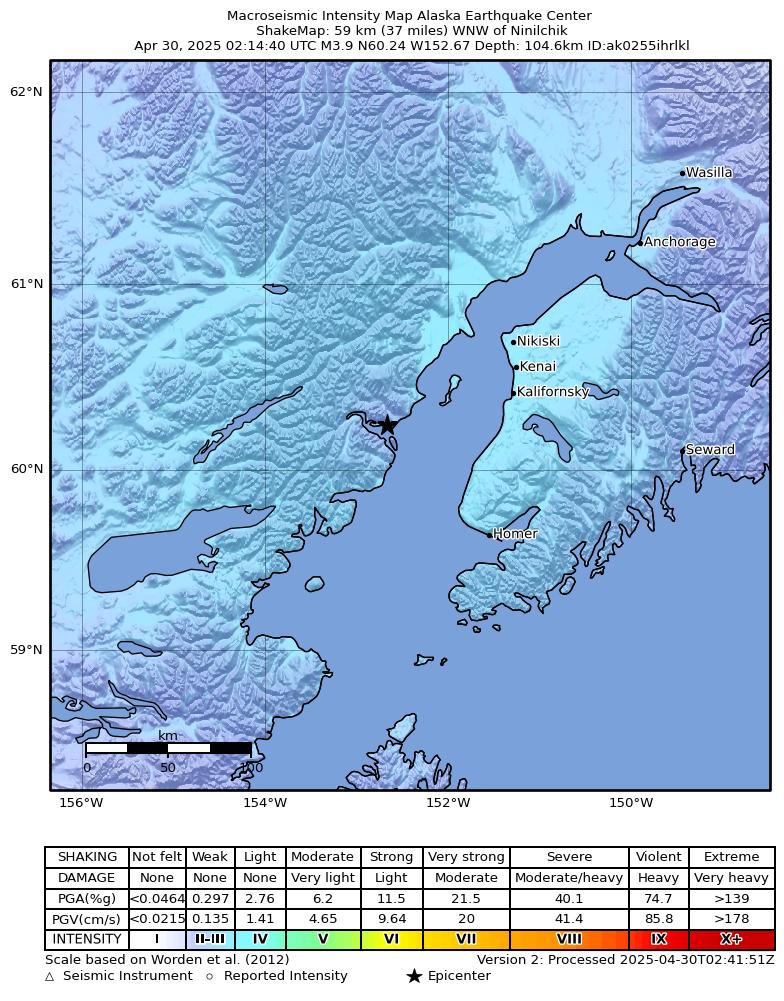
The USGS ShakeMap: shaking estimated from seismic stations and the quake’s size, on the Modified Mercalli intensity scale.
- Strongest estimated
- III, weak shaking
- Peak ground acceleration
- 1.0% of gravity
- Peak ground velocity
- 0.1 cm/s
- Map
- Automatic
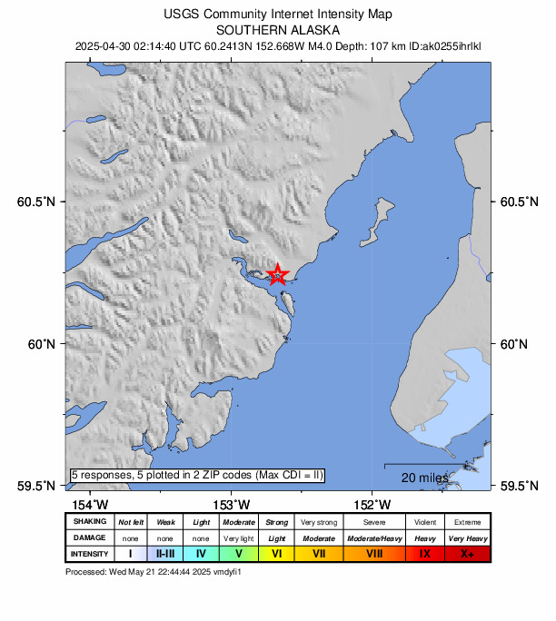
Did you feel it?
5 people reported to the USGS what they felt; the strongest reported shaking was III, weak shaking.
Fault motion and ground failure
How the rock slipped, from the moment tensor, and the USGS estimate of landslides and liquefaction.
- Faulting
- Oblique reverse
- Moment magnitude
- 4.2 Mwr
- Nodal plane 1
- Strike 62°, dip 49°, rake 42°
- Nodal plane 2
- Strike 301°, dip 59°, rake 131°
How well it is located
Reviewed by a seismologist.
- Stations used
- 201
Nearest places
Distance and direction from each place to the epicenter, with its forecast.
Nearby
Within 100 km, magnitude 1.5 and up: at least 200 in the 60 days after this one and at least 200 in the 30 days before it.
After
- 4.152 km W of Anchor Point, Alaska · 521 days ago · 86 km deep · 59 km away · felt by 30 · tsunami flag
- 2.054 km W of Anchor Point, Alaska · 521 days ago · 88 km deep · 55 km away
- 2.559 km ESE of Pedro Bay, Alaska · 520 days ago · 97 km deep · 72 km away
- 2.667 km E of Port Alsworth, Alaska · 520 days ago · 135 km deep · 24 km away
- 2.053 km WNW of Ninilchik, Alaska · 520 days ago · 103 km deep · 6 km away
- 2.973 km E of Port Alsworth, Alaska · 520 days ago · 124 km deep · 21 km away
- 1.814 km ESE of Kasilof, Alaska · 520 days ago · 52 km deep · 90 km away
- 1.915 km W of Cohoe, Alaska · 520 days ago · 60 km deep · 62 km away
- 1.612 km ESE of Nikiski, Alaska · 520 days ago · 55 km deep · 100 km away
- 2.051 km ENE of Pedro Bay, Alaska · 520 days ago · 144 km deep · 44 km away
- 2.152 km WNW of Happy Valley, Alaska · 520 days ago · 113 km deep · 18 km away · felt by 1
- 2.767 km WNW of Ninilchik, Alaska · 520 days ago · 125 km deep · 14 km away
- 1.961 km ENE of Pedro Bay, Alaska · 519 days ago · 116 km deep · 32 km away
- 1.81 km SW of Diamond Ridge, Alaska · 519 days ago · 46 km deep · 88 km away
- 1.626 km NW of Nanwalek, Alaska · 519 days ago · 45 km deep · 82 km away
- 1.830 km SE of Pedro Bay, Alaska · 519 days ago · 119 km deep · 92 km away
- 1.754 km W of Nanwalek, Alaska · 519 days ago · 92 km deep · 98 km away
- 1.936 km WSW of Anchor Point, Alaska · 519 days ago · 76 km deep · 62 km away
- 1.966 km E of Port Alsworth, Alaska · 518 days ago · 122 km deep · 25 km away
- 1.822 km WNW of Salamatof, Alaska · 518 days ago · 75 km deep · 72 km away
- 3.130 km SE of Pedro Bay, Alaska · 518 days ago · 129 km deep · 94 km away
- 1.764 km E of Port Alsworth, Alaska · 518 days ago · 124 km deep · 30 km away
- 1.838 km WNW of Nanwalek, Alaska · 518 days ago · 88 km deep · 80 km away
- 1.636 km NW of Ninilchik, Alaska · 518 days ago · 90 km deep · 30 km away
- 2.255 km E of Pedro Bay, Alaska · 518 days ago · 94 km deep · 54 km away
- 1.840 km W of Salamatof, Alaska · 518 days ago · 78 km deep · 52 km away
- 1.537 km NW of Ninilchik, Alaska · 518 days ago · 88 km deep · 25 km away
- 1.957 km WNW of Nanwalek, Alaska · 518 days ago · 101 km deep · 76 km away
- 2.153 km WNW of Nanwalek, Alaska · 517 days ago · 78 km deep · 77 km away
- 1.851 km WNW of Nanwalek, Alaska · 517 days ago · 73 km deep · 85 km away
- 1.642 km WNW of Clam Gulch, Alaska · 517 days ago · 84 km deep · 36 km away
- 1.638 km NW of Ninilchik, Alaska · 517 days ago · 77 km deep · 30 km away
- 1.757 km WNW of Anchor Point, Alaska · 517 days ago · 93 km deep · 29 km away
- 1.925 km NW of Ninilchik, Alaska · 517 days ago · 65 km deep · 41 km away · felt by 1
- 1.862 km ENE of Pedro Bay, Alaska · 516 days ago · 102 km deep · 33 km away
- 1.651 km WNW of Ninilchik, Alaska · 516 days ago · 83 km deep · 11 km away
- 1.962 km W of Anchor Point, Alaska · 516 days ago · 95 km deep · 44 km away
- 2.563 km WNW of Ninilchik, Alaska · 516 days ago · 120 km deep · 10 km away
- 1.929 km WSW of Anchor Point, Alaska · 516 days ago · 60 km deep · 60 km away
- 2.063 km ESE of Pedro Bay, Alaska · 516 days ago · 106 km deep · 85 km away
- 1.974 km NW of Ninilchik, Alaska · 515 days ago · 111 km deep · 28 km away
- 2.053 km ESE of Pedro Bay, Alaska · 515 days ago · 111 km deep · 72 km away
- 1.73 km WSW of Ridgeway, Alaska · 515 days ago · 53 km deep · 90 km away
- 1.966 km WNW of Ninilchik, Alaska · 515 days ago · 120 km deep · 7 km away · felt by 1
- 2.735 km WNW of Nanwalek, Alaska · 515 days ago · 69 km deep · 90 km away
- 1.862 km W of Tyonek, Alaska · 515 days ago · 2 km deep · 98 km away
- 2.67 km S of Clam Gulch, Alaska · 515 days ago · 67 km deep · 72 km away
- 3.048 km NE of Pedro Bay, Alaska · 515 days ago · 152 km deep · 46 km away
- 1.958 km W of Anchor Point, Alaska · 515 days ago · 99 km deep · 50 km away
- 1.943 km W of Cohoe, Alaska · 515 days ago · 81 km deep · 38 km away
- 1.961 km WNW of Anchor Point, Alaska · 515 days ago · 95 km deep · 41 km away
- 1.630 km W of Happy Valley, Alaska · 515 days ago · 72 km deep · 39 km away
- 1.917 km SE of Kasilof, Alaska · 515 days ago · 57 km deep · 91 km away
- 1.611 km N of Fritz Creek, Alaska · 515 days ago · 51 km deep · 87 km away
- 1.858 km NW of Ninilchik, Alaska · 515 days ago · 104 km deep · 26 km away
- 1.629 km W of Ninilchik, Alaska · 515 days ago · 85 km deep · 31 km away
- 1.860 km ENE of Pedro Bay, Alaska · 515 days ago · 120 km deep · 35 km away
- 1.838 km E of Pedro Bay, Alaska · 515 days ago · 123 km deep · 63 km away
- 1.665 km NW of Ninilchik, Alaska · 515 days ago · 91 km deep · 19 km away
- 1.663 km W of Tyonek, Alaska · 515 days ago · 109 km deep · 87 km away
The first 60 of at least 200.
Before
- 2.072 km WNW of Happy Valley, Alaska · 521 days ago · 111 km deep · 21 km away
- 3.041 km NE of Pedro Bay, Alaska · 521 days ago · 147 km deep · 53 km away
- 1.974 km NE of Port Alsworth, Alaska · 522 days ago · 167 km deep · 54 km away
- 2.552 km ENE of Pedro Bay, Alaska · 522 days ago · 106 km deep · 47 km away
- 2.164 km WNW of Nanwalek, Alaska · 522 days ago · 80 km deep · 80 km away
- 2.541 km ESE of Pedro Bay, Alaska · 523 days ago · 113 km deep · 78 km away
- 2.163 km WNW of Anchor Point, Alaska · 523 days ago · 112 km deep · 27 km away
- 1.854 km E of Pedro Bay, Alaska · 523 days ago · 94 km deep · 55 km away
- 1.844 km E of Pedro Bay, Alaska · 523 days ago · 114 km deep · 62 km away
- 1.854 km ENE of Port Alsworth, Alaska · 523 days ago · 156 km deep · 39 km away
- 1.860 km ENE of Pedro Bay, Alaska · 523 days ago · 120 km deep · 36 km away
- 1.670 km WNW of Nikiski, Alaska · 523 days ago · 127 km deep · 67 km away
- 1.97 km NNE of Ridgeway, Alaska · 524 days ago · 49 km deep · 99 km away
- 1.762 km WNW of Happy Valley, Alaska · 524 days ago · 116 km deep · 15 km away
- 2.158 km WNW of Happy Valley, Alaska · 524 days ago · 103 km deep · 16 km away
- 1.862 km WNW of Nanwalek, Alaska · 524 days ago · 103 km deep · 77 km away
- 2.532 km E of Pedro Bay, Alaska · 524 days ago · 136 km deep · 65 km away
- 2.863 km WNW of Happy Valley, Alaska · 524 days ago · 114 km deep · 13 km away
- 2.243 km NE of Pedro Bay, Alaska · 524 days ago · 166 km deep · 53 km away
- 1.961 km WNW of Nikiski, Alaska · 524 days ago · 112 km deep · 78 km away
Earthquakes todayAlaska earthquakesLive radar here
Sources
From the USGS Earthquake Hazards Program and its partner networks, event ak0255ihrlkl (also filed as us7000pw0f). Read Sat, Oct 3, 2026, 5:47 AM UTC.