M2.4 earthquake 7 km SE of Markleeville, CA
A magnitude 2.4 earthquake struck 7 km SE of Markleeville, CA on Wed, Oct 8, 2025, 9:23 AM PDT (16:23 UTC), -2 km (-1 mi) below the surface.
Automatic solution: the magnitude and location may still be revised.
A larger quake followed: M2.8 18 km NNW of Walker, CA. This one was a foreshock.
Map
Where this earthquake was located, with the others nearby. Select one for its page.
The earthquake
- Magnitude
- 2.4 (md), micro
- Local time
- UTC
- 2025-10-08 16:23:00 UTC
- Depth
- -2.0 km (-1.2 mi), shallow
- Epicenter
- 38.643° N, 119.742° W
- Region
- California
- Felt reports
- 2
- Tsunami flag
- No
- Status
- Automatic solution, may be revised
Did you feel it?
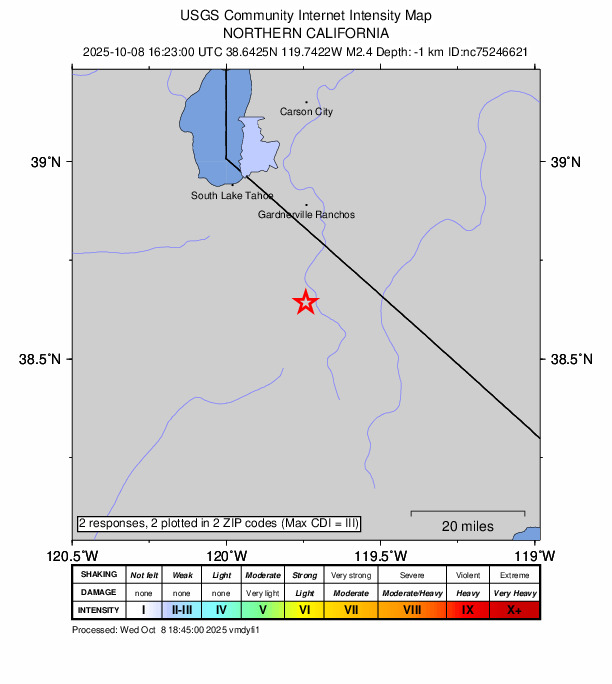
2 people reported to the USGS what they felt; the strongest reported shaking was III, weak shaking.
How well it is located
An automatic solution; a seismologist may revise it.
- Location uncertainty
- About 0.4 km horizontally, 1.7 km in depth
- Magnitude uncertainty
- ±0.24
- Depth from
- From location
- Station coverage gap
- 60°
- Stations used
- 19
Nearest places
Distance and direction from each place to the epicenter, with its forecast.
Nearby
Within 100 km, magnitude 1.5 and up: 30 in the 60 days after this one and 12 in the 30 days before it.
After
- 2.06 km N of Incline Village, Nevada · 357 days ago · 8 km deep · 77 km away
- 2.522 km NNE of Yerington, Nevada · 356 days ago · 12 km deep · 84 km away
- 2.818 km NNW of Walker, CA · 354 days ago · -1 km deep · 15 km away
- 2.47 km S of Markleeville, CA · 352 days ago · -1 km deep · 5 km away
- 1.66 km N of Incline Village, Nevada · 350 days ago · 7 km deep · 77 km away
- 1.730 km NE of Mono City, California · 349 days ago · 7 km deep · 92 km away
- 1.930 km NE of Mono City, California · 347 days ago · 8 km deep · 91 km away
- 1.514 km SSW of Walker, California · 345 days ago · 9 km deep · 30 km away
- 2.419 km SSW of Schurz, Nevada · 340 days ago · 8 km deep · 75 km away
- 1.723 km NNE of Yerington, Nevada · 339 days ago · 8 km deep · 85 km away
- 2.112 km E of Floriston, California · 338 days ago · 8 km deep · 84 km away · felt by 2
- 2.414 km E of Bodie, CA · 337 days ago · 3 km deep · 92 km away
- 1.812 km E of Floriston, California · 336 days ago · 6 km deep · 84 km away
- 1.54 km W of Walker, California · 334 days ago · 7 km deep · 23 km away
- 1.616 km NE of Yerington, Nevada · 334 days ago · 11 km deep · 79 km away
- 2.119 km NNW of Walker, CA · 332 days ago · 7 km deep · 17 km away
- 1.61 km SE of Johnson Lane, Nevada · 330 days ago · 11 km deep · 44 km away
- 1.632 km SSW of Hawthorne, Nevada · 330 days ago · 6 km deep · 90 km away
- 1.834 km E of Bridgeport, California · 329 days ago · 8 km deep · 90 km away
- 1.53 km W of Topaz Lake, Nevada · 328 days ago · 13 km deep · 15 km away
- 1.59 km NNE of Truckee, CA · 323 days ago · 6 km deep · 92 km away
- 2.420 km NNE of Yerington, Nevada · 315 days ago · 11 km deep · 82 km away · felt by 1
- 1.621 km WNW of Sunnyside-Tahoe City, CA · 313 days ago · -2 km deep · 84 km away · felt by 2
- 1.55 km ESE of Sparks, Nevada · 313 days ago · 12 km deep · 98 km away
- 2.26 km N of Bridgeport, CA · 306 days ago · 8 km deep · 59 km away
- 2.24 km SW of Walker, CA · 304 days ago · 8 km deep · 27 km away
- 2.217 km NE of Yerington, Nevada · 304 days ago · 11 km deep · 80 km away
- 1.717 km NE of Yerington, Nevada · 303 days ago · 9 km deep · 81 km away
- 2.46 km SW of Markleeville, CA · 298 days ago · -2 km deep · 10 km away
- 2.07 km SW of Markleeville, CA · 297 days ago · 0 km deep · 10 km away
Before
- 1.519 km NNE of Yerington, Nevada · 357 days ago · 7 km deep · 81 km away
- 2.07 km SE of Markleeville, CA · 358 days ago · -1 km deep · 0 km away
- 2.77 km SE of Markleeville, CA · 358 days ago · -2 km deep · 0 km away · felt by 2
- 2.57 km SE of Markleeville, CA · 358 days ago · -2 km deep · 0 km away
- 1.52 km S of Coleville, California · 363 days ago · 8 km deep · 23 km away
- 1.721 km NNE of Yerington, Nevada · 363 days ago · 7 km deep · 82 km away
- 1.920 km NNE of Yerington, Nevada · 368 days ago · 12 km deep · 82 km away
- 1.516 km NE of Yerington, Nevada · 369 days ago · 12 km deep · 79 km away
- 1.610 km SE of Schurz, Nevada · 372 days ago · 8 km deep · 91 km away
- 1.810 km SE of Schurz, Nevada · 377 days ago · 9 km deep · 91 km away
- 2.422 km NNE of Yerington, Nevada · 377 days ago · 11 km deep · 84 km away
- 1.77 km NNE of Kings Beach, CA · 386 days ago · 5 km deep · 76 km away
Earthquakes todayCalifornia earthquakesLive radar here
Sources
From the USGS Earthquake Hazards Program and its partner networks, event nc75246621 (also filed as nn00905659). Read Wed, Sep 30, 2026, 11:15 PM UTC.