M5.2 earthquake 40 km NE of Calama, Chile
A magnitude 5.2 earthquake struck 40 km NE of Calama, Chile on Wed, Jul 23, 2025, 8:46 PM GMT-4 (00:46 UTC), 106 km (66 mi) below the surface.
Map
Where this earthquake was located, with the others nearby. Select one for its page.
The earthquake
- Magnitude
- 5.2 (Mww, W-phase moment), moderate
- Magnitude from
- USGS National Earthquake Information Center
- Local time
- UTC
- 2025-07-24 00:46:20 UTC
- Depth
- 106.1 km (65.9 mi), intermediate-depth
- Epicenter
- 22.197° S, 68.648° W
- Region
- Chile
- Felt reports
- 4
- Tsunami flag
- No
- Status
- Reviewed by a seismologist
Magnitude estimates
Different scales measure different things and differ by a few tenths. The USGS marks one as preferred, and it is the one this page uses.
| Mag. | Scale | Computed by | Notes |
|---|---|---|---|
| 5.2 | Mww, W-phase moment | USGS National Earthquake Information Center | Preferred · Reviewed · ±0.068 · 21 stations |
| 5.2 | Mwr, regional moment | USGS National Earthquake Information Center | Moment tensor · Reviewed |
| 5.2 | Mww, W-phase moment | USGS, automatic first solution | First automatic solution · Confirmed |
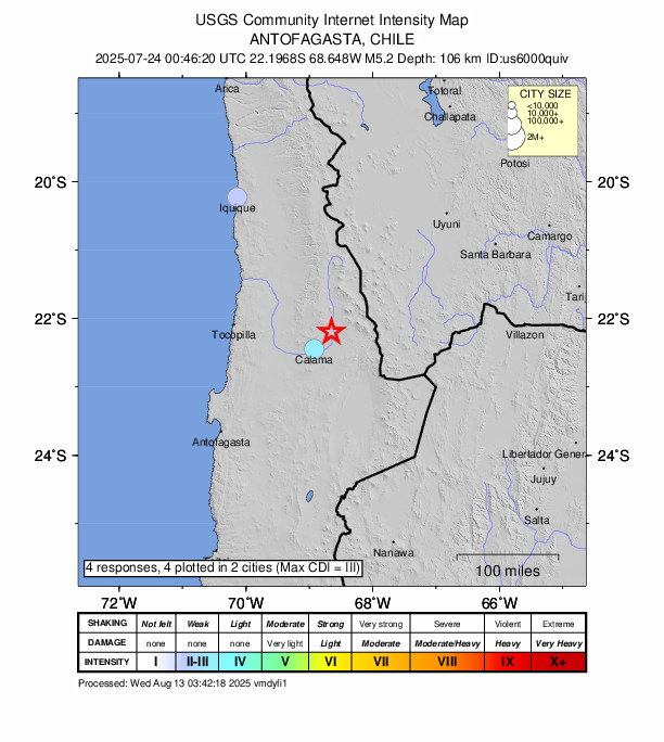
Did you feel it?
4 people reported to the USGS what they felt; the strongest reported shaking was III, weak shaking.
Fault motion and ground failure
How the rock slipped, from the moment tensor, and the USGS estimate of landslides and liquefaction.
- Faulting
- Strike-slip
- Moment magnitude
- 5.2 Mww
- Nodal plane 1
- Strike 109°, dip 35°, rake 169°
- Nodal plane 2
- Strike 208°, dip 84°, rake 56°
How well it is located
Reviewed by a seismologist.
- Location uncertainty
- About 6.0 km horizontally, 4.6 km in depth
- Magnitude uncertainty
- ±0.07
- Depth from
- From location
- Station coverage gap
- 70°
- Stations used
- 174
Nearest places
Distance and direction from each place to the epicenter, with its forecast.
Nearby
Within 100 km, magnitude 2.2 and up: 15 in the 60 days after this one and 5 in the 30 days before it.
After
- 4.453 km ENE of Calama, Chile · 435 days ago · 113 km deep · 21 km away
- 4.274 km SSW of Ollagüe, Chile · 428 days ago · 122 km deep · 44 km away
- 4.565 km SW of Ollagüe, Chile · 427 days ago · 108 km deep · 65 km away
- 4.454 km NE of Calama, Chile · 426 days ago · 118 km deep · 15 km away
- 4.659 km NNE of Calama, Chile · 424 days ago · 104 km deep · 23 km away
- 4.343 km ENE of Calama, Chile · 423 days ago · 142 km deep · 9 km away
- 4.766 km SSW of Ollagüe, Chile · 418 days ago · 115 km deep · 49 km away
- 4.239 km S of Ollagüe, Chile · 408 days ago · 131 km deep · 80 km away · felt by 1
- 4.247 km S of Ollagüe, Chile · 408 days ago · 149 km deep · 69 km away
- 4.358 km SSW of Ollagüe, Chile · 406 days ago · 132 km deep · 57 km away
- 4.671 km SSW of Ollagüe, Chile · 403 days ago · 121 km deep · 46 km away
- 4.115 km ENE of Calama, Chile · 397 days ago · 122 km deep · 26 km away
- 4.260 km SSW of Ollagüe, Chile · 393 days ago · 139 km deep · 56 km away
- 4.152 km SW of Ollagüe, Chile · 386 days ago · 134 km deep · 67 km away
- 4.548 km SSW of Ollagüe, Chile · 382 days ago · 122 km deep · 67 km away
Before
- 4.545 km S of Calama, Chile · 439 days ago · 102 km deep · 78 km away
- 4.231 km WNW of San Pedro de Atacama, Chile · 442 days ago · 111 km deep · 71 km away
- 4.243 km WSW of Ollagüe, Chile · 444 days ago · 126 km deep · 86 km away
- 4.440 km NNE of San Pedro de Atacama, Chile · 447 days ago · 154 km deep · 79 km away
- 4.228 km E of Calama, Chile · 453 days ago · 109 km deep · 24 km away
Earthquakes todayChile earthquakesLive radar here
Sources
From the USGS Earthquake Hazards Program and its partner networks, event us6000quiv (also filed as usauto6000quiv). Read Fri, Oct 2, 2026, 11:43 PM UTC.