M4.0 earthquake 119 km S of Unalaska, Alaska
A magnitude 4.0 earthquake struck 119 km S of Unalaska, Alaska on Sun, Oct 20, 2024, 7:04 PM AKDT (03:04 UTC), 35 km (22 mi) below the surface.
A larger quake followed: M4.5 74 km SSW of Unalaska, Alaska. This one was a foreshock.
Map
Where this earthquake was located, with the others nearby. Select one for its page.
The earthquake
- Magnitude
- 4.0 (Mwr, regional moment), light
- Magnitude from
- USGS National Earthquake Information Center
- Local time
- UTC
- 2024-10-21 03:04:16 UTC
- Depth
- 35.0 km (21.7 mi), shallow
- Epicenter
- 52.808° N, 166.792° W
- Region
- Alaska
- Strongest shaking
- I, not felt shaking
- Tsunami flag
- No
- Status
- Reviewed by a seismologist
Magnitude estimates
Different scales measure different things and differ by a few tenths. The USGS marks one as preferred, and it is the one this page uses.
| Mag. | Scale | Computed by | Notes |
|---|---|---|---|
| 4.0 | Mwr, regional moment | USGS National Earthquake Information Center | Preferred · Reviewed · ±0.089 · 12 stations |
| 3.7 | ML, local (Richter) | Alaska Earthquake Center | Preliminary |
Shaking
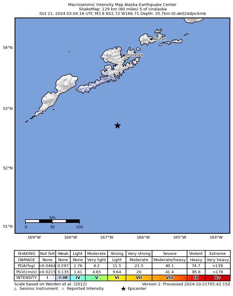
The USGS ShakeMap: shaking estimated from seismic stations and the quake’s size, on the Modified Mercalli intensity scale.
- Strongest estimated
- I, not felt shaking
- Peak ground acceleration
- 0.0% of gravity
- Peak ground velocity
- 0.0 cm/s
- Map
- Automatic
Did you feel it?
No one has reported feeling this quake to the USGS.
Fault motion and ground failure
How the rock slipped, from the moment tensor, and the USGS estimate of landslides and liquefaction.
- Faulting
- Oblique normal
- Moment magnitude
- 4.0 Mwr
- Nodal plane 1
- Strike 71°, dip 47°, rake -57°
- Nodal plane 2
- Strike 207°, dip 53°, rake -120°
How well it is located
Reviewed by a seismologist.
- Location uncertainty
- About 6.0 km horizontally, 2.0 km in depth
- Magnitude uncertainty
- ±0.09
- Depth from
- Operator assigned
- Station coverage gap
- 171°
- Stations used
- 80
Nearest places
Distance and direction from each place to the epicenter, with its forecast.
Nearby
Within 100 km, magnitude 1.5 and up: 112 in the 60 days after this one and 122 in the 30 days before it.
After
- 2.3145 km S of Unalaska, Alaska · 711 days ago · 8 km deep · 27 km away
- 1.958 km SE of Unalaska, Alaska · 710 days ago · 53 km deep · 93 km away
- 2.2118 km S of Unalaska, Alaska · 710 days ago · 2 km deep · 3 km away
- 3.1130 km S of Unalaska, Alaska · 710 days ago · 28 km deep · 15 km away
- 3.4122 km S of Unalaska, Alaska · 710 days ago · 8 km deep · 8 km away
- 1.984 km SSW of Unalaska, Alaska · 710 days ago · 26 km deep · 40 km away
- 2.9128 km S of Unalaska, Alaska · 710 days ago · 10 km deep · 12 km away
- 2.882 km SSW of Unalaska, Alaska · 710 days ago · 59 km deep · 52 km away
- 2.280 km E of Nikolski, Alaska · 710 days ago · 49 km deep · 61 km away
- 2.094 km SSW of Unalaska, Alaska · 710 days ago · 27 km deep · 37 km away
- 2.7137 km S of Unalaska, Alaska · 709 days ago · 19 km deep · 19 km away
- 2.8127 km S of Unalaska, Alaska · 709 days ago · 9 km deep · 10 km away
- 2.6143 km S of Unalaska, Alaska · 708 days ago · 10 km deep · 27 km away
- 2.087 km SSW of Unalaska, Alaska · 707 days ago · 26 km deep · 40 km away
- 1.975 km WSW of Unalaska, Alaska · 707 days ago · 29 km deep · 100 km away
- 1.838 km SW of Unalaska, Alaska · 706 days ago · 13 km deep · 92 km away
- 1.538 km SW of Unalaska, Alaska · 706 days ago · 5 km deep · 95 km away
- 2.195 km E of Nikolski, Alaska · 706 days ago · 42 km deep · 47 km away
- 1.832 km S of Unalaska, Alaska · 706 days ago · 63 km deep · 87 km away
- 1.991 km SSW of Unalaska, Alaska · 705 days ago · 37 km deep · 38 km away
- 2.186 km E of Nikolski, Alaska · 704 days ago · 26 km deep · 53 km away
- 2.7105 km SE of Unalaska, Alaska · 704 days ago · 35 km deep · 93 km away
- 1.876 km SW of Unalaska, Alaska · 703 days ago · 11 km deep · 80 km away
- 2.068 km E of Nikolski, Alaska · 703 days ago · 36 km deep · 71 km away
- 1.986 km SSW of Unalaska, Alaska · 702 days ago · 20 km deep · 39 km away
- 1.989 km SSW of Unalaska, Alaska · 701 days ago · 26 km deep · 36 km away
- 1.752 km SW of Unalaska, Alaska · 701 days ago · 22 km deep · 91 km away
- 2.3133 km ESE of Nikolski, Alaska · 701 days ago · 3 km deep · 24 km away
- 2.056 km SW of Unalaska, Alaska · 700 days ago · 73 km deep · 87 km away
- 2.9122 km S of Unalaska, Alaska · 700 days ago · 35 km deep · 4 km away
- 2.1111 km S of Unalaska, Alaska · 700 days ago · 22 km deep · 9 km away
- 2.186 km S of Unalaska, Alaska · 698 days ago · 36 km deep · 35 km away
- 2.188 km SSW of Unalaska, Alaska · 698 days ago · 33 km deep · 37 km away
- 2.558 km SSW of Unalaska, Alaska · 695 days ago · 10 km deep · 68 km away
- 3.374 km SSE of Unalaska, Alaska · 693 days ago · 35 km deep · 56 km away
- 2.186 km SSW of Unalaska, Alaska · 692 days ago · 26 km deep · 41 km away
- 2.086 km SSW of Unalaska, Alaska · 692 days ago · 19 km deep · 41 km away
- 2.286 km SSW of Unalaska, Alaska · 692 days ago · 35 km deep · 39 km away
- 1.960 km S of Unalaska, Alaska · 692 days ago · 28 km deep · 60 km away
- 2.081 km SSW of Unalaska, Alaska · 692 days ago · 45 km deep · 45 km away
- 2.096 km SSW of Unalaska, Alaska · 690 days ago · 13 km deep · 28 km away
- 1.784 km SSW of Unalaska, Alaska · 689 days ago · 38 km deep · 35 km away
- 1.840 km S of Unalaska, Alaska · 689 days ago · 63 km deep · 83 km away
- 1.982 km SSW of Unalaska, Alaska · 688 days ago · 45 km deep · 45 km away
- 1.990 km E of Nikolski, Alaska · 688 days ago · 26 km deep · 50 km away
- 2.277 km SW of Unalaska, Alaska · 688 days ago · 76 km deep · 81 km away
- 1.884 km SSW of Unalaska, Alaska · 688 days ago · 26 km deep · 40 km away
- 1.862 km SSE of Unalaska, Alaska · 687 days ago · 26 km deep · 76 km away
- 2.172 km WSW of Unalaska, Alaska · 686 days ago · 13 km deep · 92 km away
- 1.949 km SSE of Unalaska, Alaska · 685 days ago · 46 km deep · 75 km away
- 3.188 km SSW of Unalaska, Alaska · 684 days ago · 35 km deep · 40 km away
- 1.875 km SW of Unalaska, Alaska · 683 days ago · 13 km deep · 82 km away
- 2.078 km ENE of Nikolski, Alaska · 682 days ago · 59 km deep · 72 km away
- 2.036 km S of Unalaska, Alaska · 682 days ago · 78 km deep · 83 km away
- 1.583 km SW of Unalaska, Alaska · 681 days ago · 61 km deep · 62 km away
- 1.662 km SSE of Unalaska, Alaska · 681 days ago · 34 km deep · 64 km away
- 1.891 km NE of Nikolski, Alaska · 679 days ago · 78 km deep · 94 km away
- 2.6131 km S of Unalaska, Alaska · 679 days ago · 6 km deep · 15 km away
- 1.8138 km S of Unalaska, Alaska · 679 days ago · 13 km deep · 21 km away
- 2.0138 km S of Unalaska, Alaska · 679 days ago · 7 km deep · 22 km away
The first 60 of 112.
Before
- 1.987 km SSW of Unalaska, Alaska · 711 days ago · 26 km deep · 37 km away
- 2.0163 km SSE of Unalaska, Alaska · 711 days ago · 5 km deep · 87 km away
- 1.684 km SSW of Unalaska, Alaska · 711 days ago · 18 km deep · 41 km away
- 1.671 km SE of Unalaska, Alaska · 711 days ago · 26 km deep · 98 km away
- 1.568 km SE of Unalaska, Alaska · 711 days ago · 23 km deep · 99 km away
- 2.794 km SSW of Unalaska, Alaska · 712 days ago · 35 km deep · 53 km away
- 2.995 km ESE of Nikolski, Alaska · 712 days ago · 34 km deep · 65 km away
- 1.587 km SSW of Unalaska, Alaska · 712 days ago · 13 km deep · 40 km away
- 2.1116 km SSE of Unalaska, Alaska · 713 days ago · 10 km deep · 63 km away
- 2.690 km SSW of Unalaska, Alaska · 713 days ago · 35 km deep · 36 km away
- 1.988 km E of Nikolski, Alaska · 713 days ago · 41 km deep · 51 km away
- 2.275 km SSW of Unalaska, Alaska · 714 days ago · 64 km deep · 58 km away
- 3.194 km SSW of Unalaska, Alaska · 714 days ago · 35 km deep · 32 km away
- 1.657 km SW of Unalaska, Alaska · 714 days ago · 13 km deep · 91 km away
- 1.984 km SSW of Unalaska, Alaska · 715 days ago · 26 km deep · 41 km away
- 2.274 km SE of Unalaska, Alaska · 715 days ago · 44 km deep · 88 km away
- 2.075 km SSE of Unalaska, Alaska · 715 days ago · 21 km deep · 76 km away
- 1.968 km SE of Unalaska, Alaska · 715 days ago · 22 km deep · 84 km away
- 2.1134 km S of Unalaska, Alaska · 716 days ago · 15 km deep · 15 km away
- 1.8112 km SSE of Unalaska, Alaska · 716 days ago · 26 km deep · 83 km away
Earthquakes todayAlaska earthquakesLive radar here
Sources
From the USGS Earthquake Hazards Program and its partner networks, event us6000nzzq (also filed as ak024djxckmb). Read Thu, Oct 1, 2026, 5:16 PM UTC.