M1.5 earthquake 32 km SE of Minto, Alaska
A magnitude 1.5 earthquake struck 32 km SE of Minto, Alaska on Fri, Aug 9, 2024, 1:20 PM AKDT (21:20 UTC), 15 km (9 mi) below the surface.
A larger quake followed: M4.4 34 km ENE of Ferry, Alaska. This one was a foreshock.
Map
Where this earthquake was located, with the others nearby. Select one for its page.
The earthquake
- Magnitude
- 1.5 (ML, local (Richter)), micro
- Magnitude from
- Alaska Earthquake Center
- Local time
- UTC
- 2024-08-09 21:20:09 UTC
- Depth
- 15.0 km (9.3 mi), shallow
- Epicenter
- 64.922° N, 148.912° W
- Region
- Alaska
- Felt reports
- 1
- Tsunami flag
- No
- Status
- Reviewed by a seismologist
Did you feel it?
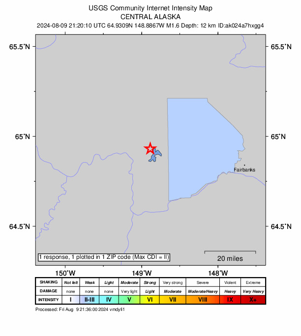
1 person reported to the USGS what they felt; the strongest reported shaking was II, weak shaking.
How well it is located
Reviewed by a seismologist.
- Stations used
- 28
Nearest places
Distance and direction from each place to the epicenter, with its forecast.
Nearby
Within 100 km, magnitude 1.5 and up: 24 in the 60 days after this one and 11 in the 30 days before it.
After
- 1.721 km NE of Four Mile Road, Alaska · 782 days ago · 16 km deep · 18 km away
- 1.933 km SE of Minto, Alaska · 777 days ago · 19 km deep · 1 km away
- 1.915 km NW of Four Mile Road, Alaska · 768 days ago · 17 km deep · 33 km away
- 1.54 km SE of Eielson Air Force Base, Alaska · 767 days ago · 4 km deep · 97 km away
- 1.75 km SE of Eielson Air Force Base, Alaska · 767 days ago · 3 km deep · 98 km away
- 1.628 km SW of Ester, Alaska · 765 days ago · 7 km deep · 39 km away
- 2.117 km SE of Livengood, Alaska · 764 days ago · 10 km deep · 65 km away
- 1.617 km SW of Nenana, Alaska · 760 days ago · 14 km deep · 55 km away · felt by 1
- 1.632 km W of Clear, Alaska · 756 days ago · 9 km deep · 87 km away
- 1.617 km WNW of Four Mile Road, Alaska · 747 days ago · 15 km deep · 40 km away
- 1.943 km SSW of North Pole, Alaska · 742 days ago · 17 km deep · 79 km away
- 2.216 km ESE of Livengood, Alaska · 742 days ago · 10 km deep · 66 km away
- 1.64 km S of Minto, Alaska · 740 days ago · 17 km deep · 30 km away
- 2.457 km ENE of Ferry, Alaska · 740 days ago · 107 km deep · 97 km away
- 2.16 km NW of Four Mile Road, Alaska · 740 days ago · 18 km deep · 34 km away
- 4.434 km ENE of Ferry, Alaska · 739 days ago · 114 km deep · 94 km away · felt by 2
- 1.533 km W of Ester, Alaska · 736 days ago · 22 km deep · 11 km away
- 1.657 km WNW of Anderson, Alaska · 735 days ago · 3 km deep · 83 km away
- 3.533 km ENE of Ferry, Alaska · 732 days ago · 112 km deep · 94 km away
- 2.423 km ENE of Minto, Alaska · 731 days ago · 7 km deep · 36 km away
- 1.518 km ESE of Livengood, Alaska · 730 days ago · 6 km deep · 67 km away
- 1.539 km ENE of Ferry, Alaska · 729 days ago · 9 km deep · 95 km away
- 1.59 km WSW of Manley Hot Springs, Alaska · 729 days ago · 18 km deep · 91 km away
- 2.619 km ESE of Livengood, Alaska · 728 days ago · 7 km deep · 69 km away
Before
- 2.833 km SE of Minto, Alaska · 786 days ago · 18 km deep · 0 km away
- 1.921 km N of Four Mile Road, Alaska · 788 days ago · 14 km deep · 19 km away · felt by 2
- 2.423 km WSW of Ester, Alaska · 793 days ago · 22 km deep · 25 km away · felt by 5
- 1.630 km SSE of Minto, Alaska · 800 days ago · 21 km deep · 4 km away
- 2.028 km SSE of Minto, Alaska · 800 days ago · 20 km deep · 6 km away
- 2.519 km NW of Anderson, Alaska · 800 days ago · 11 km deep · 59 km away
- 1.617 km NW of Anderson, Alaska · 801 days ago · 13 km deep · 59 km away
- 1.716 km NW of Anderson, Alaska · 801 days ago · 6 km deep · 59 km away
- 2.140 km WNW of Anderson, Alaska · 815 days ago · 15 km deep · 75 km away
- 2.27 km W of Two Rivers, Alaska · 816 days ago · 18 km deep · 81 km away · felt by 2
- 1.75 km NNW of College, Alaska · 816 days ago · 15 km deep · 51 km away
Earthquakes todayAlaska earthquakesLive radar here
Sources
From the USGS Earthquake Hazards Program and its partner networks, event ak024a7hxgg4. Read Mon, Oct 5, 2026, 3:47 AM UTC.