M2.6 earthquake 28 km SSE of Midland, Texas
A magnitude 2.6 earthquake struck 28 km SSE of Midland, Texas on Sun, Mar 10, 2024, 3:45 AM CDT (08:45 UTC), 6 km (4 mi) below the surface.
A larger quake followed: M4.4 21 km N of Stanton, Texas. This one was a foreshock.
Map
Where this earthquake was located, with the others nearby. Select one for its page.
The earthquake
- Magnitude
- 2.6 (ml), micro
- Local time
- UTC
- 2024-03-10 08:45:06 UTC
- Depth
- 6.0 km (3.7 mi), shallow
- Epicenter
- 31.773° N, 101.935° W
- Region
- Texas
- Felt reports
- 1
- Tsunami flag
- No
- Status
- Reviewed by a seismologist
Did you feel it?
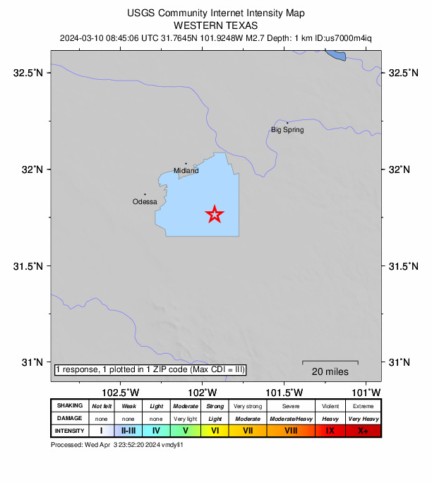
1 person reported to the USGS what they felt; the strongest reported shaking was III, weak shaking.
How well it is located
Reviewed by a seismologist.
- Location uncertainty
- About 0.6 km horizontally, 1.5 km in depth
- Magnitude uncertainty
- ±0.10
- Station coverage gap
- 58°
- Stations used
- 18
Nearest places
Distance and direction from each place to the epicenter, with its forecast.
Nearby
Within 100 km, magnitude 1.5 and up: 128 in the 60 days after this one and 61 in the 30 days before it.
After
- 1.637 km NW of Stanton, Texas · 934 days ago · 8 km deep · 67 km away
- 1.836 km E of McKinney Acres, Texas · 934 days ago · 7 km deep · 64 km away
- 1.719 km NW of Stanton, Texas · 933 days ago · 5 km deep · 55 km away
- 2.336 km SSW of Los Ybanez, Texas · 933 days ago · 7 km deep · 75 km away
- 2.232 km WSW of Ackerly, Texas · 932 days ago · 8 km deep · 72 km away
- 1.722 km W of Garden City, Texas · 931 days ago · 6 km deep · 23 km away
- 1.63 km S of Midland, Texas · 931 days ago · 8 km deep · 25 km away
- 1.621 km N of Stanton, Texas · 931 days ago · 7 km deep · 62 km away
- 2.415 km N of Big Spring, Texas · 930 days ago · 7 km deep · 82 km away
- 2.332 km WSW of Ackerly, Texas · 930 days ago · 9 km deep · 71 km away
- 1.532 km WSW of Ackerly, Texas · 929 days ago · 8 km deep · 72 km away
- 1.735 km ENE of McKinney Acres, Texas · 929 days ago · 8 km deep · 70 km away
- 1.531 km SSW of Los Ybanez, Texas · 927 days ago · 5 km deep · 79 km away
- 1.58 km ESE of Ackerly, Texas · 926 days ago · 8 km deep · 84 km away
- 1.514 km SE of Ackerly, Texas · 926 days ago · 5 km deep · 82 km away
- 1.511 km S of Forsan, Texas · 924 days ago · 4 km deep · 59 km away
- 2.524 km SSW of Westbrook, Texas · 924 days ago · 9 km deep · 91 km away · felt by 1
- 1.624 km S of Westbrook, Texas · 924 days ago · 3 km deep · 92 km away
- 2.77 km SSE of Midland, Texas · 923 days ago · 9 km deep · 21 km away · felt by 34
- 1.535 km WSW of Ackerly, Texas · 922 days ago · 8 km deep · 71 km away
- 3.019 km NW of Stanton, Texas · 922 days ago · 6 km deep · 54 km away
- 1.519 km NW of Stanton, Texas · 922 days ago · 9 km deep · 54 km away
- 1.619 km NW of Stanton, Texas · 922 days ago · 9 km deep · 54 km away
- 1.821 km N of Stanton, Texas · 921 days ago · 6 km deep · 63 km away
- 2.723 km SSW of Westbrook, Texas · 921 days ago · 1 km deep · 92 km away
- 2.125 km S of Westbrook, Texas · 921 days ago · 0 km deep · 91 km away
- 1.925 km SSW of Westbrook, Texas · 920 days ago · 9 km deep · 90 km away
- 1.536 km ENE of McKinney Acres, Texas · 920 days ago · 9 km deep · 73 km away
- 1.823 km SSW of Westbrook, Texas · 919 days ago · 2 km deep · 91 km away
- 1.735 km WSW of Ackerly, Texas · 919 days ago · 10 km deep · 71 km away
- 2.418 km NNW of Goldsmith, Texas · 917 days ago · 4 km deep · 80 km away
- 1.625 km E of McKinney Acres, Texas · 917 days ago · 11 km deep · 65 km away
- 1.828 km SW of Garden City, Texas · 917 days ago · 8 km deep · 23 km away
- 1.714 km NNW of Midland, Texas · 917 days ago · 8 km deep · 43 km away
- 2.528 km SW of Garden City, Texas · 917 days ago · 8 km deep · 23 km away · felt by 1
- 1.622 km W of Garden City, Texas · 916 days ago · 7 km deep · 23 km away
- 1.624 km SSW of Westbrook, Texas · 915 days ago · 3 km deep · 91 km away
- 1.535 km SSE of Midland, Texas · 914 days ago · 8 km deep · 9 km away
- 1.633 km WSW of Ackerly, Texas · 913 days ago · 9 km deep · 72 km away
- 2.126 km SSW of Westbrook, Texas · 913 days ago · 8 km deep · 89 km away
- 1.534 km SSW of Los Ybanez, Texas · 913 days ago · 9 km deep · 75 km away
- 2.338 km NW of Stanton, Texas · 912 days ago · 7 km deep · 66 km away
- 1.628 km SW of Garden City, Texas · 912 days ago · 8 km deep · 23 km away
- 2.514 km ESE of Stanton, Texas · 912 days ago · 6 km deep · 45 km away
- 1.925 km W of Garden City, Texas · 910 days ago · 9 km deep · 22 km away
- 1.724 km W of Garden City, Texas · 910 days ago · 8 km deep · 23 km away
- 1.514 km ESE of Stanton, Texas · 910 days ago · 6 km deep · 44 km away
- 1.624 km SSW of Westbrook, Texas · 910 days ago · 6 km deep · 92 km away
- 1.72 km ENE of Gardendale, Texas · 910 days ago · 7 km deep · 49 km away
- 1.825 km W of Garden City, Texas · 910 days ago · 9 km deep · 22 km away
- 1.824 km W of Garden City, Texas · 910 days ago · 9 km deep · 23 km away
- 1.539 km WSW of Ackerly, Texas · 909 days ago · 5 km deep · 69 km away
- 1.916 km NW of Stanton, Texas · 908 days ago · 6 km deep · 51 km away
- 1.518 km SSE of Ackerly, Texas · 908 days ago · 7 km deep · 72 km away
- 1.916 km NW of Stanton, Texas · 908 days ago · 6 km deep · 51 km away
- 1.624 km S of Westbrook, Texas · 908 days ago · 9 km deep · 93 km away
- 1.525 km S of Westbrook, Texas · 908 days ago · 7 km deep · 93 km away
- 1.625 km S of Westbrook, Texas · 908 days ago · 2 km deep · 92 km away
- 2.025 km W of Garden City, Texas · 906 days ago · 8 km deep · 22 km away
- 1.836 km SSW of Los Ybanez, Texas · 906 days ago · 6 km deep · 75 km away
The first 60 of 128.
Before
- 1.923 km S of Westbrook, Texas · 935 days ago · 1 km deep · 92 km away
- 2.219 km NW of Stanton, Texas · 936 days ago · 8 km deep · 55 km away
- 1.634 km ENE of McKinney Acres, Texas · 938 days ago · 8 km deep · 70 km away
- 3.837 km SSW of Los Ybanez, Texas · 940 days ago · 6 km deep · 75 km away · felt by 12
- 1.533 km ENE of McKinney Acres, Texas · 940 days ago · 8 km deep · 69 km away
- 1.637 km NW of Stanton, Texas · 940 days ago · 11 km deep · 67 km away
- 1.635 km SE of Midland, Texas · 940 days ago · 12 km deep · 9 km away
- 1.527 km S of Westbrook, Texas · 940 days ago · 3 km deep · 90 km away
- 1.624 km SSW of Westbrook, Texas · 941 days ago · 3 km deep · 91 km away
- 1.625 km E of Forsan, Texas · 941 days ago · 6 km deep · 88 km away
- 2.427 km SSE of Midland, Texas · 942 days ago · 6 km deep · 2 km away · felt by 1
- 2.023 km ENE of Forsan, Texas · 944 days ago · 7 km deep · 88 km away
- 1.626 km SSE of Midland, Texas · 944 days ago · 8 km deep · 2 km away
- 2.523 km SSW of Westbrook, Texas · 944 days ago · 5 km deep · 89 km away
- 2.323 km SE of Coahoma, Texas · 945 days ago · 7 km deep · 88 km away
- 1.723 km SSW of Westbrook, Texas · 945 days ago · 3 km deep · 92 km away
- 1.712 km W of Forsan, Texas · 945 days ago · 9 km deep · 57 km away
- 1.624 km SSW of Westbrook, Texas · 945 days ago · 6 km deep · 91 km away
- 1.619 km SE of Ackerly, Texas · 945 days ago · 6 km deep · 81 km away
- 1.724 km E of Forsan, Texas · 946 days ago · 3 km deep · 88 km away
Earthquakes todayTexas earthquakesLive radar here
Sources
From the USGS Earthquake Hazards Program and its partner networks, event tx2024ewtc (also filed as us7000m4iq). Read Wed, Sep 30, 2026, 9:12 PM UTC.