M5.0 earthquake 97 km SE of False Pass, Alaska
A magnitude 5.0 earthquake struck 97 km SE of False Pass, Alaska on Mon, Dec 9, 2024, 8:34 AM AKST (17:34 UTC), 35 km (22 mi) below the surface.
Map
Where this earthquake was located, with the others nearby. Select one for its page.
The earthquake
- Magnitude
- 5.0 (mww), moderate
- Local time
- UTC
- 2024-12-09 17:34:04 UTC
- Depth
- 35.0 km (21.7 mi), shallow
- Epicenter
- 54.177° N, 162.448° W
- Region
- Alaska
- Felt reports
- 1
- Strongest shaking
- IV, light shaking
- Tsunami flag
- No
- Status
- Reviewed by a seismologist
Shaking
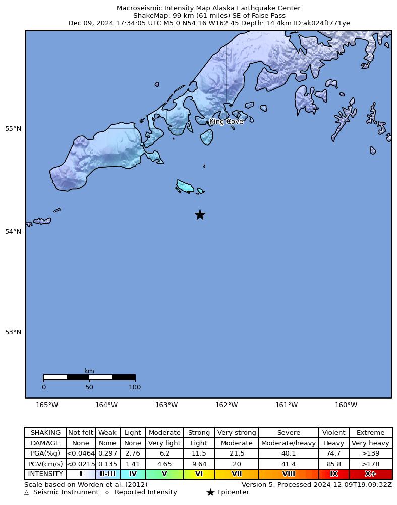
The USGS ShakeMap: shaking estimated from seismic stations and the quake’s size, on the Modified Mercalli intensity scale.
- Strongest estimated
- IV, light shaking
- Peak ground acceleration
- 2.9% of gravity
- Peak ground velocity
- 2.2 cm/s
- Map
- Automatic
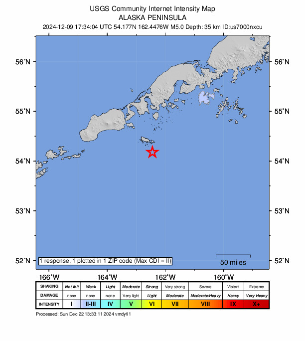
Did you feel it?
1 person reported to the USGS what they felt; the strongest reported shaking was II, weak shaking.
Aftershock forecast
The chance of at least one aftershock this large or larger, from the USGS operational aftershock forecast, issued Tue, Dec 9, 2025, 5:34 PM UTC. The USGS updates it as the sequence unfolds.
| Within | M3+ | M4+ | M5+ | M6+ | M7+ |
|---|---|---|---|---|---|
| 1 day | Under 1% | Under 1% | Under 1% | Under 1% | Under 1% |
| 1 week | Under 1% | Under 1% | Under 1% | Under 1% | Under 1% |
| 1 month | 3% | Under 1% | Under 1% | Under 1% | Under 1% |
| 1 year | 25% | 3% | Under 1% | Under 1% | Under 1% |
In the coming week the USGS expects about 0 aftershocks of magnitude 3 or more, and most likely between 0 and 0.
Fault motion and ground failure
How the rock slipped, from the moment tensor, and the USGS estimate of landslides and liquefaction.
- Faulting
- Reverse (thrust)
- Moment magnitude
- 5.0 Mww
- Nodal plane 1
- Strike 59°, dip 58°, rake 93°
- Nodal plane 2
- Strike 233°, dip 32°, rake 85°
How well it is located
Reviewed by a seismologist.
- Location uncertainty
- About 3.7 km horizontally, 1.9 km in depth
- Magnitude uncertainty
- ±0.07
- Depth from
- Operator assigned
- Station coverage gap
- 133°
- Stations used
- 146
Nearest places
Distance and direction from each place to the epicenter, with its forecast.
Nearby
Within 100 km, magnitude 2.0 and up: 92 in the 60 days after this one and 58 in the 30 days before it.
After
- 2.794 km S of King Cove, Alaska · 660 days ago · 10 km deep · 4 km away
- 2.686 km SE of King Cove, Alaska · 660 days ago · 9 km deep · 92 km away
- 2.134 km S of False Pass, Alaska · 659 days ago · 12 km deep · 80 km away
- 2.169 km SE of King Cove, Alaska · 659 days ago · 19 km deep · 63 km away
- 3.140 km SE of King Cove, Alaska · 658 days ago · 64 km deep · 83 km away
- 2.596 km SSE of King Cove, Alaska · 658 days ago · 35 km deep · 65 km away
- 2.051 km ESE of False Pass, Alaska · 657 days ago · 63 km deep · 52 km away
- 2.135 km S of False Pass, Alaska · 657 days ago · 11 km deep · 80 km away
- 2.089 km SE of King Cove, Alaska · 657 days ago · 16 km deep · 72 km away
- 2.683 km S of King Cove, Alaska · 656 days ago · 19 km deep · 16 km away
- 2.4121 km S of False Pass, Alaska · 656 days ago · 27 km deep · 63 km away
- 2.1110 km SSW of Sand Point, Alaska · 654 days ago · 7 km deep · 98 km away
- 2.225 km SSE of False Pass, Alaska · 653 days ago · 13 km deep · 75 km away
- 2.322 km S of Cold Bay, Alaska · 653 days ago · 117 km deep · 92 km away
- 2.662 km SE of King Cove, Alaska · 653 days ago · 35 km deep · 66 km away
- 2.7100 km S of False Pass, Alaska · 653 days ago · 35 km deep · 67 km away
- 2.698 km SSE of False Pass, Alaska · 651 days ago · 35 km deep · 42 km away
- 2.037 km S of False Pass, Alaska · 651 days ago · 11 km deep · 76 km away
- 2.182 km SE of King Cove, Alaska · 650 days ago · 20 km deep · 65 km away
- 2.7100 km SSE of False Pass, Alaska · 650 days ago · 22 km deep · 40 km away
- 3.0101 km SSE of False Pass, Alaska · 650 days ago · 35 km deep · 47 km away
- 2.794 km SSW of False Pass, Alaska · 649 days ago · 35 km deep · 84 km away
- 2.591 km S of False Pass, Alaska · 649 days ago · 35 km deep · 70 km away
- 2.052 km SSE of King Cove, Alaska · 648 days ago · 41 km deep · 55 km away
- 2.178 km SSE of King Cove, Alaska · 648 days ago · 26 km deep · 48 km away
- 2.184 km SE of False Pass, Alaska · 648 days ago · 8 km deep · 14 km away
- 2.765 km SE of King Cove, Alaska · 647 days ago · 62 km deep · 78 km away
- 3.2117 km S of False Pass, Alaska · 646 days ago · 41 km deep · 59 km away
- 2.030 km SSW of False Pass, Alaska · 646 days ago · 13 km deep · 82 km away
- 2.131 km SSW of False Pass, Alaska · 646 days ago · 13 km deep · 83 km away
- 2.134 km S of False Pass, Alaska · 646 days ago · 12 km deep · 80 km away
- 2.134 km S of False Pass, Alaska · 645 days ago · 12 km deep · 80 km away
- 2.134 km S of False Pass, Alaska · 645 days ago · 12 km deep · 80 km away
- 2.257 km SSE of King Cove, Alaska · 643 days ago · 63 km deep · 64 km away
- 2.892 km SE of False Pass, Alaska · 643 days ago · 35 km deep · 6 km away
- 2.887 km SE of King Cove, Alaska · 642 days ago · 35 km deep · 65 km away
- 2.096 km SSE of King Cove, Alaska · 642 days ago · 26 km deep · 60 km away
- 2.797 km S of False Pass, Alaska · 641 days ago · 35 km deep · 66 km away
- 2.173 km SE of King Cove, Alaska · 641 days ago · 18 km deep · 75 km away
- 3.181 km S of King Cove, Alaska · 641 days ago · 35 km deep · 30 km away
- 3.054 km SSE of King Cove, Alaska · 640 days ago · 35 km deep · 65 km away
- 2.446 km SSE of King Cove, Alaska · 639 days ago · 49 km deep · 64 km away
- 2.380 km S of False Pass, Alaska · 639 days ago · 38 km deep · 56 km away
- 2.173 km SSE of King Cove, Alaska · 638 days ago · 16 km deep · 54 km away
- 2.029 km S of False Pass, Alaska · 636 days ago · 13 km deep · 83 km away
- 2.6103 km S of False Pass, Alaska · 636 days ago · 35 km deep · 83 km away
- 2.295 km SSW of False Pass, Alaska · 634 days ago · 26 km deep · 99 km away
- 2.584 km SSE of False Pass, Alaska · 633 days ago · 35 km deep · 44 km away
- 2.982 km SE of King Cove, Alaska · 633 days ago · 22 km deep · 66 km away
- 2.881 km SE of King Cove, Alaska · 632 days ago · 35 km deep · 65 km away
- 2.7125 km S of False Pass, Alaska · 632 days ago · 35 km deep · 71 km away
- 2.0101 km SSW of Sand Point, Alaska · 631 days ago · 1 km deep · 100 km away
- 2.694 km SE of King Cove, Alaska · 631 days ago · 27 km deep · 66 km away
- 2.983 km S of False Pass, Alaska · 629 days ago · 35 km deep · 70 km away
- 2.7122 km SSE of False Pass, Alaska · 625 days ago · 35 km deep · 40 km away
- 2.875 km SE of King Cove, Alaska · 624 days ago · 35 km deep · 66 km away
- 2.727 km SSW of King Cove, Alaska · 623 days ago · 118 km deep · 72 km away
- 2.391 km S of False Pass, Alaska · 623 days ago · 40 km deep · 80 km away
- 3.8121 km SSE of False Pass, Alaska · 622 days ago · 35 km deep · 46 km away
- 2.783 km S of False Pass, Alaska · 622 days ago · 35 km deep · 49 km away
The first 60 of 92.
Before
- 2.222 km SSE of False Pass, Alaska · 660 days ago · 13 km deep · 78 km away
- 3.973 km SE of King Cove, Alaska · 661 days ago · 35 km deep · 75 km away
- 2.994 km S of False Pass, Alaska · 661 days ago · 35 km deep · 72 km away
- 2.178 km SE of King Cove, Alaska · 662 days ago · 19 km deep · 90 km away
- 2.036 km SE of False Pass, Alaska · 662 days ago · 61 km deep · 61 km away
- 2.195 km SSE of False Pass, Alaska · 662 days ago · 26 km deep · 14 km away
- 2.054 km SSW of King Cove, Alaska · 663 days ago · 86 km deep · 51 km away
- 2.079 km SE of King Cove, Alaska · 663 days ago · 18 km deep · 66 km away
- 2.2146 km S of False Pass, Alaska · 663 days ago · 26 km deep · 100 km away
- 2.283 km SSE of King Cove, Alaska · 663 days ago · 14 km deep · 59 km away
- 2.643 km SSW of King Cove, Alaska · 663 days ago · 80 km deep · 62 km away
- 2.2113 km SSE of False Pass, Alaska · 664 days ago · 26 km deep · 37 km away
- 2.694 km SSE of King Cove, Alaska · 664 days ago · 10 km deep · 56 km away
- 2.2113 km SSW of False Pass, Alaska · 665 days ago · 17 km deep · 95 km away
- 3.8109 km SSW of Sand Point, Alaska · 665 days ago · 30 km deep · 95 km away
- 2.285 km SSE of King Cove, Alaska · 665 days ago · 14 km deep · 58 km away
- 2.880 km SSE of King Cove, Alaska · 665 days ago · 24 km deep · 60 km away
- 2.561 km SSE of King Cove, Alaska · 666 days ago · 31 km deep · 63 km away
- 3.8113 km SSW of Sand Point, Alaska · 666 days ago · 35 km deep · 98 km away
- 2.665 km SSE of King Cove, Alaska · 667 days ago · 35 km deep · 58 km away
Earthquakes todayAlaska earthquakesLive radar here
Sources
From the USGS Earthquake Hazards Program and its partner networks, event us7000nxcu (also filed as ak024ft771ye). Read Wed, Sep 30, 2026, 6:06 PM UTC.