M4.4 earthquake 164 km S of False Pass, Alaska
A magnitude 4.4 earthquake struck 164 km S of False Pass, Alaska on Sun, Dec 1, 2024, 1:26 PM AKST (22:26 UTC), 10 km (6 mi) below the surface.
Map
Where this earthquake was located, with the others nearby. Select one for its page.
The earthquake
- Magnitude
- 4.4 (mwr), light
- Local time
- UTC
- 2024-12-01 22:26:35 UTC
- Depth
- 9.8 km (6.1 mi), shallow
- Epicenter
- 53.372° N, 163.445° W
- Region
- Alaska
- Strongest shaking
- I, not felt shaking
- Tsunami flag
- No
- Status
- Reviewed by a seismologist
Shaking
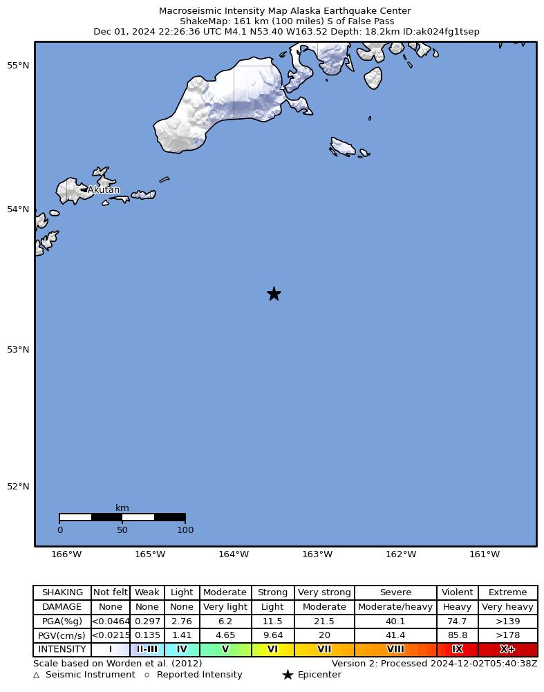
The USGS ShakeMap: shaking estimated from seismic stations and the quake’s size, on the Modified Mercalli intensity scale.
- Strongest estimated
- I, not felt shaking
- Peak ground acceleration
- 0.0% of gravity
- Peak ground velocity
- 0.0 cm/s
- Map
- Automatic
Did you feel it?
No one has reported feeling this quake to the USGS.
Fault motion and ground failure
How the rock slipped, from the moment tensor, and the USGS estimate of landslides and liquefaction.
- Faulting
- Oblique reverse
- Moment magnitude
- 4.4 Mwr
- Nodal plane 1
- Strike 218°, dip 33°, rake 59°
- Nodal plane 2
- Strike 74°, dip 62°, rake 108°
How well it is located
Reviewed by a seismologist.
- Location uncertainty
- About 2.2 km horizontally, 4.6 km in depth
- Magnitude uncertainty
- ±0.08
- Depth from
- From location
- Station coverage gap
- 167°
- Stations used
- 123
Nearest places
Distance and direction from each place to the epicenter, with its forecast.
Nearby
Within 100 km, magnitude 1.5 and up: 107 in the 60 days after this one and 43 in the 30 days before it.
After
- 3.1159 km S of False Pass, Alaska · 666 days ago · 10 km deep · 10 km away
- 2.7160 km S of False Pass, Alaska · 666 days ago · 10 km deep · 9 km away
- 3.2154 km S of False Pass, Alaska · 666 days ago · 10 km deep · 16 km away
- 2.7155 km S of False Pass, Alaska · 666 days ago · 10 km deep · 15 km away
- 2.5161 km S of False Pass, Alaska · 666 days ago · 10 km deep · 8 km away
- 1.991 km S of False Pass, Alaska · 666 days ago · 26 km deep · 74 km away
- 2.0118 km SSW of False Pass, Alaska · 666 days ago · 18 km deep · 64 km away
- 2.3159 km S of False Pass, Alaska · 666 days ago · 26 km deep · 12 km away
- 3.185 km SE of Akutan, Alaska · 665 days ago · 35 km deep · 100 km away
- 2.695 km SE of Akutan, Alaska · 665 days ago · 35 km deep · 85 km away
- 2.8220 km SE of Akutan, Alaska · 665 days ago · 10 km deep · 79 km away
- 2.9213 km SE of Akutan, Alaska · 665 days ago · 10 km deep · 67 km away
- 2.999 km E of Akutan, Alaska · 665 days ago · 32 km deep · 88 km away
- 2.7155 km S of False Pass, Alaska · 664 days ago · 33 km deep · 12 km away
- 2.2104 km ESE of Akutan, Alaska · 664 days ago · 26 km deep · 74 km away
- 2.7161 km S of False Pass, Alaska · 664 days ago · 35 km deep · 7 km away
- 2.7146 km S of False Pass, Alaska · 664 days ago · 52 km deep · 23 km away
- 2.2113 km SSW of False Pass, Alaska · 663 days ago · 17 km deep · 59 km away
- 2.9198 km SE of Akutan, Alaska · 663 days ago · 10 km deep · 64 km away
- 2.2113 km SSE of False Pass, Alaska · 662 days ago · 26 km deep · 74 km away
- 2.6231 km SE of Akutan, Alaska · 662 days ago · 10 km deep · 97 km away
- 2.2146 km S of False Pass, Alaska · 662 days ago · 26 km deep · 19 km away
- 2.087 km SE of Akutan, Alaska · 661 days ago · 56 km deep · 89 km away
- 2.195 km SSE of False Pass, Alaska · 661 days ago · 26 km deep · 98 km away
- 2.696 km SE of Akutan, Alaska · 660 days ago · 35 km deep · 88 km away
- 3.690 km SE of Akutan, Alaska · 660 days ago · 35 km deep · 90 km away
- 3.285 km SE of Akutan, Alaska · 660 days ago · 35 km deep · 95 km away
- 2.994 km S of False Pass, Alaska · 660 days ago · 35 km deep · 70 km away
- 3.3103 km SE of Akutan, Alaska · 659 days ago · 35 km deep · 76 km away
- 3.185 km E of Akutan, Alaska · 658 days ago · 10 km deep · 99 km away
- 3.9213 km SE of Akutan, Alaska · 657 days ago · 10 km deep · 70 km away
- 3.3231 km SE of Akutan, Alaska · 657 days ago · 10 km deep · 84 km away
- 2.6138 km ESE of Akutan, Alaska · 656 days ago · 35 km deep · 37 km away
- 3.1110 km ESE of Akutan, Alaska · 655 days ago · 35 km deep · 65 km away
- 2.4121 km S of False Pass, Alaska · 654 days ago · 27 km deep · 49 km away
- 2.8126 km SSW of False Pass, Alaska · 654 days ago · 35 km deep · 55 km away
- 3.4119 km ESE of Akutan, Alaska · 654 days ago · 35 km deep · 63 km away
- 3.3112 km ESE of Akutan, Alaska · 654 days ago · 35 km deep · 67 km away
- 3.0121 km ESE of Akutan, Alaska · 653 days ago · 20 km deep · 58 km away
- 2.5120 km ESE of Akutan, Alaska · 653 days ago · 35 km deep · 60 km away
- 2.397 km ESE of Akutan, Alaska · 653 days ago · 41 km deep · 81 km away
- 2.492 km SE of Akutan, Alaska · 652 days ago · 60 km deep · 91 km away
- 2.7100 km S of False Pass, Alaska · 652 days ago · 35 km deep · 65 km away
- 2.695 km E of Akutan, Alaska · 651 days ago · 35 km deep · 90 km away
- 2.4102 km ESE of Akutan, Alaska · 650 days ago · 23 km deep · 76 km away
- 2.698 km SSE of False Pass, Alaska · 649 days ago · 35 km deep · 75 km away
- 2.693 km SSW of False Pass, Alaska · 649 days ago · 32 km deep · 95 km away
- 2.694 km SSW of False Pass, Alaska · 649 days ago · 35 km deep · 88 km away
- 2.7100 km SSE of False Pass, Alaska · 649 days ago · 22 km deep · 75 km away
- 3.0101 km SSE of False Pass, Alaska · 649 days ago · 35 km deep · 70 km away
- 2.296 km E of Akutan, Alaska · 649 days ago · 13 km deep · 96 km away
- 2.885 km SE of Akutan, Alaska · 648 days ago · 35 km deep · 98 km away
- 2.794 km SSW of False Pass, Alaska · 648 days ago · 35 km deep · 74 km away
- 2.591 km S of False Pass, Alaska · 648 days ago · 35 km deep · 74 km away
- 2.992 km SE of Akutan, Alaska · 648 days ago · 35 km deep · 86 km away
- 3.0219 km SE of Akutan, Alaska · 646 days ago · 10 km deep · 75 km away
- 3.1235 km SE of Akutan, Alaska · 646 days ago · 10 km deep · 77 km away
- 3.2117 km S of False Pass, Alaska · 645 days ago · 41 km deep · 54 km away
- 2.191 km SSW of False Pass, Alaska · 642 days ago · 28 km deep · 99 km away
- 2.582 km SE of Akutan, Alaska · 642 days ago · 35 km deep · 99 km away
The first 60 of 107.
Before
- 2.788 km S of False Pass, Alaska · 668 days ago · 35 km deep · 77 km away
- 3.2233 km SE of Akutan, Alaska · 669 days ago · 32 km deep · 88 km away
- 3.3114 km ESE of Akutan, Alaska · 669 days ago · 35 km deep · 63 km away
- 2.9162 km S of False Pass, Alaska · 670 days ago · 10 km deep · 12 km away
- 2.0101 km ESE of Akutan, Alaska · 672 days ago · 39 km deep · 80 km away
- 1.9121 km SSW of False Pass, Alaska · 673 days ago · 24 km deep · 61 km away
- 2.7250 km S of False Pass, Alaska · 673 days ago · 10 km deep · 90 km away
- 3.193 km E of Akutan, Alaska · 673 days ago · 35 km deep · 94 km away
- 2.9233 km SSE of False Pass, Alaska · 673 days ago · 10 km deep · 91 km away
- 3.1223 km SE of Akutan, Alaska · 673 days ago · 10 km deep · 79 km away
- 2.084 km ESE of Akutan, Alaska · 674 days ago · 51 km deep · 96 km away
- 2.0113 km SSE of False Pass, Alaska · 676 days ago · 26 km deep · 67 km away
- 1.876 km S of False Pass, Alaska · 676 days ago · 46 km deep · 89 km away
- 1.893 km SE of Akutan, Alaska · 677 days ago · 26 km deep · 84 km away
- 1.9108 km S of False Pass, Alaska · 677 days ago · 18 km deep · 59 km away
- 3.0143 km SSE of False Pass, Alaska · 677 days ago · 10 km deep · 45 km away
- 3.1141 km SSE of False Pass, Alaska · 678 days ago · 30 km deep · 46 km away
- 2.7156 km SSE of False Pass, Alaska · 678 days ago · 32 km deep · 51 km away
- 3.7134 km SSE of False Pass, Alaska · 678 days ago · 36 km deep · 49 km away
- 2.6141 km SSE of False Pass, Alaska · 678 days ago · 11 km deep · 44 km away
Earthquakes todayAlaska earthquakesLive radar here
Sources
From the USGS Earthquake Hazards Program and its partner networks, event us7000nvc0 (also filed as ak024fg1tsep). Read Tue, Sep 29, 2026, 7:00 AM UTC.