M4.3 earthquake 15 km WNW of False Pass, Alaska
A magnitude 4.3 earthquake struck 15 km WNW of False Pass, Alaska on Fri, Oct 18, 2024, 11:59 AM AKDT (19:59 UTC), 95 km (59 mi) below the surface.
Map
Where this earthquake was located, with the others nearby. Select one for its page.
The earthquake
- Magnitude
- 4.3 (mwr), light
- Local time
- UTC
- 2024-10-18 19:59:41 UTC
- Depth
- 95.1 km (59.1 mi), intermediate-depth
- Epicenter
- 54.923° N, 163.619° W
- Region
- Alaska
- Strongest shaking
- III, weak shaking
- Tsunami flag
- No
- Status
- Reviewed by a seismologist
Shaking
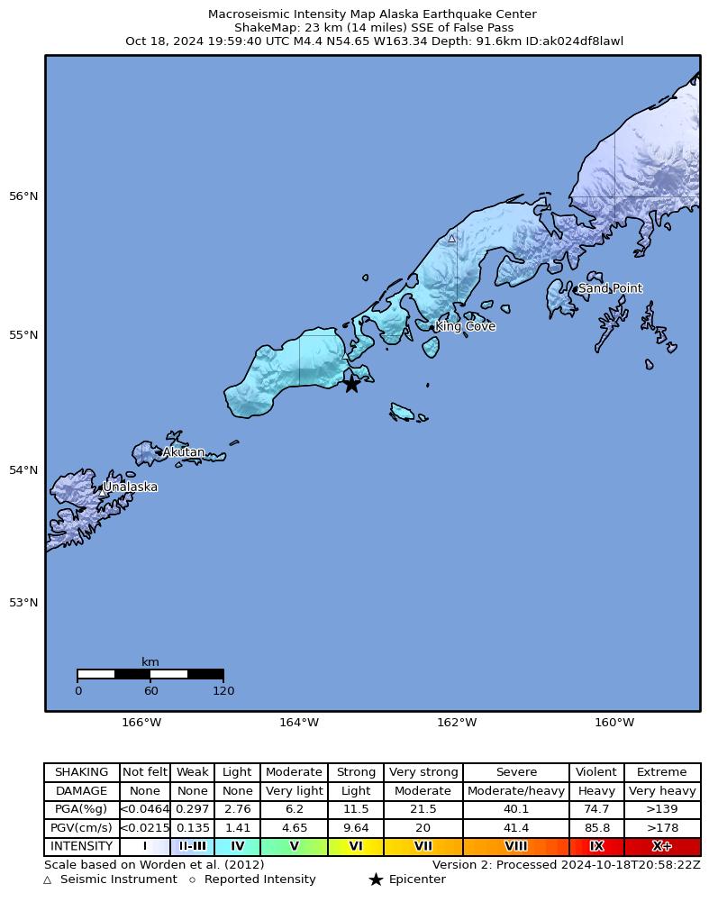
The USGS ShakeMap: shaking estimated from seismic stations and the quake’s size, on the Modified Mercalli intensity scale.
- Strongest estimated
- III, weak shaking
- Peak ground acceleration
- 0.8% of gravity
- Peak ground velocity
- 0.3 cm/s
- Map
- Automatic
Did you feel it?
No one has reported feeling this quake to the USGS.
Fault motion and ground failure
How the rock slipped, from the moment tensor, and the USGS estimate of landslides and liquefaction.
- Faulting
- Strike-slip
- Moment magnitude
- 4.3 Mwr
- Nodal plane 1
- Strike 46°, dip 65°, rake -177°
- Nodal plane 2
- Strike 314°, dip 87°, rake -25°
How well it is located
Reviewed by a seismologist.
- Location uncertainty
- About 5.9 km horizontally, 3.5 km in depth
- Magnitude uncertainty
- ±0.09
- Depth from
- From location
- Station coverage gap
- 46°
- Stations used
- 160
Nearest places
Distance and direction from each place to the epicenter, with its forecast.
Nearby
Within 100 km, magnitude 1.5 and up: 92 in the 60 days after this one and 44 in the 30 days before it.
After
- 2.246 km ESE of False Pass, Alaska · 710 days ago · 85 km deep · 62 km away
- 1.952 km S of False Pass, Alaska · 709 days ago · 13 km deep · 61 km away
- 1.647 km S of False Pass, Alaska · 709 days ago · 15 km deep · 55 km away
- 2.893 km SSW of False Pass, Alaska · 709 days ago · 57 km deep · 95 km away
- 1.55 km ESE of King Cove, Alaska · 709 days ago · 1 km deep · 89 km away
- 4.077 km NNW of False Pass, Alaska · 708 days ago · 208 km deep · 65 km away
- 1.644 km S of False Pass, Alaska · 708 days ago · 14 km deep · 54 km away
- 2.910 km SSW of False Pass, Alaska · 707 days ago · 126 km deep · 19 km away
- 1.932 km SSW of False Pass, Alaska · 706 days ago · 12 km deep · 40 km away
- 1.936 km S of False Pass, Alaska · 706 days ago · 12 km deep · 44 km away
- 2.593 km SSW of False Pass, Alaska · 706 days ago · 34 km deep · 95 km away
- 1.735 km S of False Pass, Alaska · 706 days ago · 9 km deep · 43 km away
- 1.935 km S of False Pass, Alaska · 706 days ago · 5 km deep · 44 km away
- 2.512 km NNE of King Cove, Alaska · 706 days ago · 120 km deep · 91 km away
- 1.935 km S of False Pass, Alaska · 705 days ago · 6 km deep · 43 km away
- 3.197 km SSW of False Pass, Alaska · 703 days ago · 35 km deep · 99 km away
- 2.992 km S of False Pass, Alaska · 703 days ago · 35 km deep · 99 km away
- 2.591 km E of Akutan, Alaska · 702 days ago · 37 km deep · 96 km away
- 3.022 km SE of King Cove, Alaska · 702 days ago · 77 km deep · 98 km away
- 1.984 km SE of False Pass, Alaska · 701 days ago · 12 km deep · 99 km away
- 1.644 km SSW of King Cove, Alaska · 701 days ago · 11 km deep · 65 km away
- 3.1105 km NW of Cold Bay, Alaska · 701 days ago · 172 km deep · 96 km away
- 2.046 km SE of False Pass, Alaska · 701 days ago · 45 km deep · 61 km away
- 2.765 km S of False Pass, Alaska · 700 days ago · 35 km deep · 75 km away
- 3.984 km SSE of False Pass, Alaska · 698 days ago · 35 km deep · 95 km away
- 2.239 km S of False Pass, Alaska · 698 days ago · 80 km deep · 49 km away
- 1.737 km S of False Pass, Alaska · 698 days ago · 11 km deep · 45 km away
- 2.187 km S of False Pass, Alaska · 697 days ago · 25 km deep · 94 km away
- 1.635 km S of False Pass, Alaska · 694 days ago · 11 km deep · 43 km away
- 2.253 km SSW of False Pass, Alaska · 694 days ago · 20 km deep · 57 km away
- 2.033 km SSW of False Pass, Alaska · 694 days ago · 13 km deep · 40 km away
- 1.632 km SSW of False Pass, Alaska · 694 days ago · 13 km deep · 40 km away
- 1.835 km SSW of False Pass, Alaska · 694 days ago · 11 km deep · 43 km away
- 2.316 km S of False Pass, Alaska · 694 days ago · 94 km deep · 28 km away
- 2.646 km S of False Pass, Alaska · 694 days ago · 11 km deep · 55 km away
- 2.987 km S of False Pass, Alaska · 692 days ago · 50 km deep · 94 km away
- 2.168 km WSW of False Pass, Alaska · 692 days ago · 5 km deep · 58 km away
- 2.032 km SW of King Cove, Alaska · 690 days ago · 94 km deep · 65 km away
- 2.136 km SSW of False Pass, Alaska · 690 days ago · 9 km deep · 44 km away
- 1.827 km S of False Pass, Alaska · 689 days ago · 5 km deep · 35 km away
- 2.853 km S of King Cove, Alaska · 689 days ago · 50 km deep · 93 km away
- 1.989 km SSW of False Pass, Alaska · 687 days ago · 38 km deep · 92 km away
- 1.857 km SSW of False Pass, Alaska · 687 days ago · 10 km deep · 62 km away
- 1.634 km SSW of False Pass, Alaska · 686 days ago · 13 km deep · 42 km away
- 1.630 km WSW of False Pass, Alaska · 685 days ago · 37 km deep · 25 km away
- 1.733 km SSW of False Pass, Alaska · 684 days ago · 13 km deep · 41 km away
- 3.979 km E of Akutan, Alaska · 682 days ago · 77 km deep · 97 km away
- 3.026 km NNW of False Pass, Alaska · 680 days ago · 118 km deep · 18 km away
- 2.725 km SSE of King Cove, Alaska · 680 days ago · 84 km deep · 91 km away
- 2.392 km SSW of False Pass, Alaska · 679 days ago · 26 km deep · 94 km away
- 2.08 km SSE of False Pass, Alaska · 678 days ago · 92 km deep · 23 km away
- 1.838 km S of King Cove, Alaska · 677 days ago · 53 km deep · 85 km away
- 2.253 km S of King Cove, Alaska · 677 days ago · 81 km deep · 96 km away
- 3.430 km SSE of King Cove, Alaska · 677 days ago · 91 km deep · 100 km away
- 1.868 km SSW of False Pass, Alaska · 676 days ago · 63 km deep · 73 km away
- 1.876 km S of False Pass, Alaska · 676 days ago · 46 km deep · 85 km away
- 1.678 km SE of False Pass, Alaska · 676 days ago · 13 km deep · 93 km away
- 1.680 km SW of False Pass, Alaska · 675 days ago · 20 km deep · 80 km away
- 1.984 km SE of False Pass, Alaska · 675 days ago · 12 km deep · 99 km away
- 2.124 km E of False Pass, Alaska · 675 days ago · 95 km deep · 39 km away
The first 60 of 92.
Before
- 1.784 km WSW of False Pass, Alaska · 712 days ago · 5 km deep · 78 km away
- 1.938 km SE of False Pass, Alaska · 712 days ago · 61 km deep · 54 km away
- 2.070 km S of King Cove, Alaska · 712 days ago · 60 km deep · 95 km away
- 2.665 km SSW of False Pass, Alaska · 713 days ago · 59 km deep · 71 km away
- 2.086 km SW of False Pass, Alaska · 713 days ago · 74 km deep · 84 km away
- 1.885 km ENE of Akutan, Alaska · 714 days ago · 11 km deep · 82 km away
- 2.617 km NNE of False Pass, Alaska · 714 days ago · 142 km deep · 24 km away
- 2.187 km SW of False Pass, Alaska · 714 days ago · 11 km deep · 82 km away
- 2.283 km ENE of Akutan, Alaska · 715 days ago · 7 km deep · 85 km away
- 2.651 km SE of False Pass, Alaska · 716 days ago · 61 km deep · 66 km away
- 2.283 km ENE of Akutan, Alaska · 718 days ago · 9 km deep · 85 km away
- 1.542 km SW of False Pass, Alaska · 718 days ago · 13 km deep · 40 km away
- 1.859 km SSW of False Pass, Alaska · 719 days ago · 65 km deep · 64 km away
- 1.822 km N of King Cove, Alaska · 719 days ago · 132 km deep · 93 km away
- 1.593 km SSW of False Pass, Alaska · 719 days ago · 50 km deep · 93 km away
- 2.083 km ENE of Akutan, Alaska · 721 days ago · 9 km deep · 85 km away
- 2.679 km S of False Pass, Alaska · 721 days ago · 61 km deep · 87 km away
- 2.184 km ENE of Akutan, Alaska · 722 days ago · 8 km deep · 83 km away
- 1.582 km ENE of Akutan, Alaska · 722 days ago · 10 km deep · 86 km away
- 2.258 km SSW of False Pass, Alaska · 723 days ago · 60 km deep · 62 km away
Earthquakes todayAlaska earthquakesLive radar here
Sources
From the USGS Earthquake Hazards Program and its partner networks, event us6000nzlx (also filed as ak024df8lawl). Read Tue, Sep 29, 2026, 1:16 AM UTC.