M4.0 earthquake 69 km NE of Adak, Alaska
A magnitude 4.0 earthquake struck 69 km NE of Adak, Alaska on Sat, Jul 6, 2024, 7:22 AM HADT (16:22 UTC), 166 km (103 mi) below the surface.
Map
Where this earthquake was located, with the others nearby. Select one for its page.
The earthquake
- Magnitude
- 4.0 (mb, body-wave), light
- Magnitude from
- USGS National Earthquake Information Center
- Local time
- UTC
- 2024-07-06 16:22:13 UTC
- Depth
- 166.2 km (103.2 mi), intermediate-depth
- Epicenter
- 52.396° N, 176.068° W
- Region
- Alaska
- Strongest shaking
- II, weak shaking
- Tsunami flag
- No
- Status
- Reviewed by a seismologist
Magnitude estimates
Different scales measure different things and differ by a few tenths. The USGS marks one as preferred, and it is the one this page uses.
| Mag. | Scale | Computed by | Notes |
|---|---|---|---|
| 4.0 | mb, body-wave | USGS National Earthquake Information Center | Preferred · Reviewed · ±0.047 · 128 stations |
| 3.7 | ML, local (Richter) | Alaska Earthquake Center | Preliminary |
Shaking
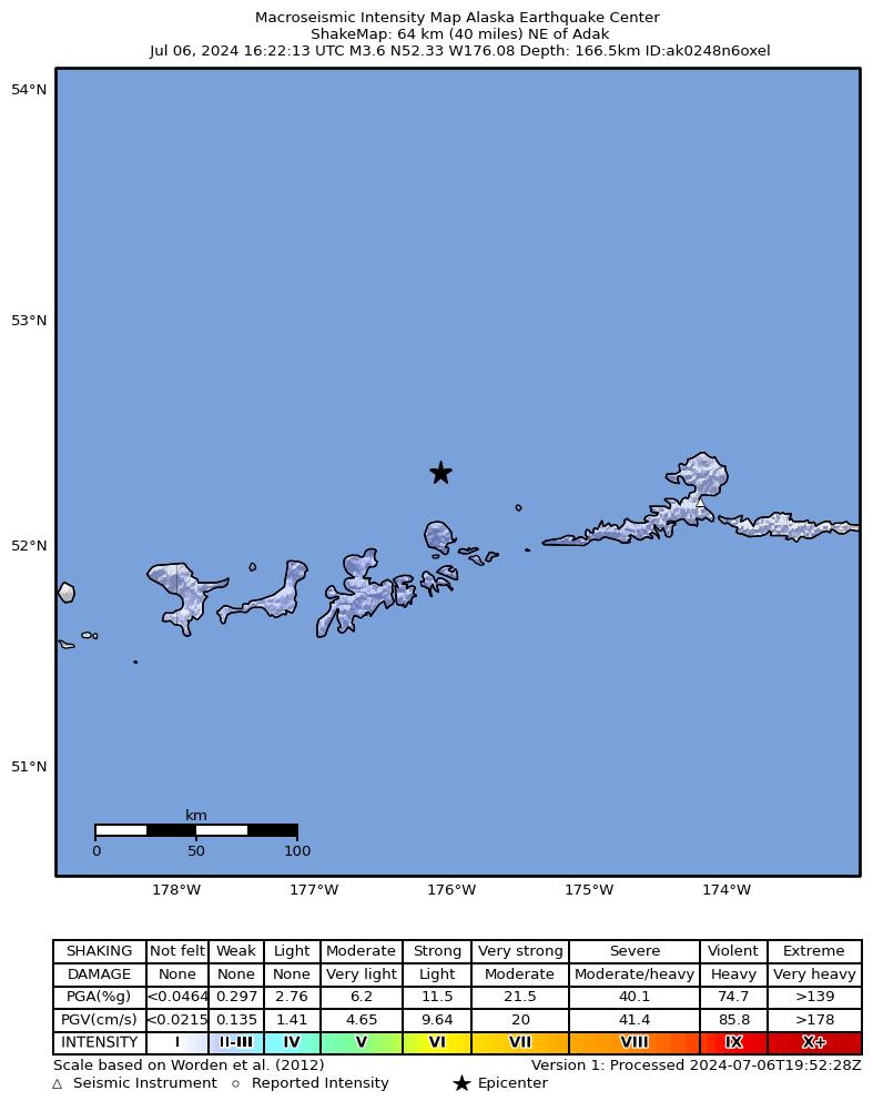
The USGS ShakeMap: shaking estimated from seismic stations and the quake’s size, on the Modified Mercalli intensity scale.
- Strongest estimated
- II, weak shaking
- Peak ground acceleration
- 0.1% of gravity
- Peak ground velocity
- 0.0 cm/s
- Map
- Automatic
Did you feel it?
No one has reported feeling this quake to the USGS.
How well it is located
Reviewed by a seismologist.
- Location uncertainty
- About 7.5 km horizontally, 4.5 km in depth
- Magnitude uncertainty
- ±0.05
- Depth from
- From location
- Station coverage gap
- 65°
- Stations used
- 154
Nearby
Within 100 km, magnitude 1.5 and up: 87 in the 60 days after this one and 44 in the 30 days before it.
After
- 1.654 km SE of Adak, Alaska · 817 days ago · 28 km deep · 99 km away
- 1.514 km W of Adak, Alaska · 817 days ago · 10 km deep · 78 km away
- 1.949 km WSW of Atka, Alaska · 816 days ago · 73 km deep · 96 km away
- 3.749 km NW of Atka, Alaska · 815 days ago · 221 km deep · 91 km away
- 1.930 km NE of Adak, Alaska · 813 days ago · 105 km deep · 40 km away
- 2.969 km ENE of Adak, Alaska · 813 days ago · 153 km deep · 35 km away
- 1.826 km SSW of Adak, Alaska · 812 days ago · 64 km deep · 96 km away
- 2.570 km ESE of Adak, Alaska · 812 days ago · 35 km deep · 92 km away
- 2.238 km NW of Atka, Alaska · 812 days ago · 165 km deep · 99 km away
- 2.140 km WSW of Atka, Alaska · 812 days ago · 78 km deep · 99 km away
- 1.882 km ENE of Adak, Alaska · 811 days ago · 12 km deep · 50 km away
- 1.517 km W of Adak, Alaska · 810 days ago · 65 km deep · 82 km away
- 1.734 km E of Adak, Alaska · 810 days ago · 79 km deep · 57 km away
- 1.541 km E of Adak, Alaska · 810 days ago · 77 km deep · 58 km away
- 1.657 km WSW of Atka, Alaska · 809 days ago · 74 km deep · 87 km away
- 1.671 km ENE of Adak, Alaska · 808 days ago · 87 km deep · 46 km away
- 1.976 km ENE of Adak, Alaska · 806 days ago · 174 km deep · 30 km away
- 3.158 km ENE of Adak, Alaska · 804 days ago · 171 km deep · 40 km away
- 1.739 km SE of Adak, Alaska · 803 days ago · 56 km deep · 82 km away
- 3.062 km ESE of Adak, Alaska · 801 days ago · 67 km deep · 78 km away
- 1.728 km ENE of Adak, Alaska · 801 days ago · 100 km deep · 48 km away
- 2.779 km NE of Adak, Alaska · 801 days ago · 181 km deep · 27 km away
- 1.673 km ESE of Adak, Alaska · 801 days ago · 25 km deep · 95 km away
- 2.071 km WSW of Atka, Alaska · 800 days ago · 64 km deep · 80 km away
- 2.042 km SSE of Adak, Alaska · 800 days ago · 34 km deep · 99 km away
- 1.672 km ESE of Adak, Alaska · 800 days ago · 60 km deep · 81 km away
- 3.049 km SE of Adak, Alaska · 799 days ago · 35 km deep · 99 km away
- 1.552 km SE of Adak, Alaska · 798 days ago · 28 km deep · 97 km away
- 3.663 km ESE of Adak, Alaska · 798 days ago · 35 km deep · 90 km away
- 3.321 km S of Adak, Alaska · 795 days ago · 79 km deep · 88 km away
- 2.855 km ENE of Adak, Alaska · 795 days ago · 192 km deep · 31 km away
- 1.833 km ESE of Adak, Alaska · 795 days ago · 71 km deep · 72 km away
- 1.517 km S of Adak, Alaska · 794 days ago · 67 km deep · 86 km away
- 3.360 km E of Adak, Alaska · 794 days ago · 70 km deep · 70 km away
- 1.748 km W of Atka, Alaska · 794 days ago · 98 km deep · 84 km away
- 2.241 km WNW of Adak, Alaska · 791 days ago · 108 km deep · 91 km away
- 1.647 km SSE of Adak, Alaska · 791 days ago · 23 km deep · 98 km away
- 3.449 km N of Adak, Alaska · 791 days ago · 224 km deep · 32 km away
- 2.767 km ENE of Adak, Alaska · 790 days ago · 147 km deep · 30 km away
- 2.632 km E of Adak, Alaska · 788 days ago · 134 km deep · 62 km away
- 1.945 km WSW of Atka, Alaska · 788 days ago · 92 km deep · 93 km away
- 2.770 km NE of Adak, Alaska · 786 days ago · 196 km deep · 3 km away
- 2.268 km ESE of Adak, Alaska · 784 days ago · 42 km deep · 88 km away
- 2.747 km NE of Adak, Alaska · 783 days ago · 137 km deep · 25 km away
- 1.944 km E of Adak, Alaska · 781 days ago · 139 km deep · 59 km away
- 1.814 km WSW of Adak, Alaska · 780 days ago · 76 km deep · 81 km away
- 2.956 km ENE of Adak, Alaska · 779 days ago · 221 km deep · 39 km away
- 1.659 km ESE of Adak, Alaska · 779 days ago · 36 km deep · 87 km away
- 2.557 km NE of Adak, Alaska · 778 days ago · 164 km deep · 22 km away
- 2.936 km SSE of Adak, Alaska · 778 days ago · 48 km deep · 95 km away
- 1.728 km SW of Adak, Alaska · 777 days ago · 26 km deep · 97 km away
- 2.519 km S of Adak, Alaska · 775 days ago · 81 km deep · 85 km away
- 2.024 km SSW of Adak, Alaska · 775 days ago · 73 km deep · 94 km away
- 2.575 km W of Atka, Alaska · 774 days ago · 14 km deep · 61 km away
- 2.447 km E of Adak, Alaska · 773 days ago · 131 km deep · 54 km away
- 1.726 km SSW of Adak, Alaska · 772 days ago · 38 km deep · 96 km away
- 2.950 km NNE of Adak, Alaska · 772 days ago · 268 km deep · 25 km away
- 1.912 km S of Adak, Alaska · 772 days ago · 69 km deep · 81 km away
- 1.985 km WSW of Atka, Alaska · 772 days ago · 71 km deep · 71 km away
- 2.937 km NW of Atka, Alaska · 771 days ago · 175 km deep · 99 km away
The first 60 of 87.
Before
- 1.862 km ESE of Adak, Alaska · 818 days ago · 30 km deep · 89 km away
- 1.978 km E of Adak, Alaska · 819 days ago · 76 km deep · 62 km away
- 1.881 km SW of Atka, Alaska · 819 days ago · 45 km deep · 99 km away
- 3.253 km NW of Atka, Alaska · 820 days ago · 208 km deep · 99 km away
- 3.176 km ENE of Adak, Alaska · 821 days ago · 176 km deep · 35 km away
- 3.814 km SSE of Adak, Alaska · 822 days ago · 87 km deep · 77 km away
- 1.620 km WSW of Adak, Alaska · 822 days ago · 11 km deep · 89 km away
- 1.952 km WNW of Adak, Alaska · 822 days ago · 115 km deep · 100 km away
- 1.860 km SE of Adak, Alaska · 824 days ago · 26 km deep · 99 km away
- 1.958 km SE of Adak, Alaska · 824 days ago · 27 km deep · 98 km away
- 5.066 km W of Atka, Alaska · 825 days ago · 101 km deep · 63 km away
- 1.726 km SSW of Adak, Alaska · 826 days ago · 44 km deep · 95 km away
- 1.970 km ESE of Adak, Alaska · 826 days ago · 64 km deep · 78 km away
- 2.914 km S of Adak, Alaska · 827 days ago · 66 km deep · 83 km away
- 1.918 km W of Adak, Alaska · 829 days ago · 8 km deep · 79 km away
- 1.567 km W of Atka, Alaska · 830 days ago · 116 km deep · 61 km away
- 2.253 km NE of Adak, Alaska · 830 days ago · 144 km deep · 22 km away
- 1.529 km SW of Adak, Alaska · 831 days ago · 82 km deep · 97 km away
- 2.654 km SE of Adak, Alaska · 831 days ago · 35 km deep · 97 km away
- 3.125 km NE of Adak, Alaska · 831 days ago · 23 km deep · 46 km away
Earthquakes todayAlaska earthquakesLive radar here
Sources
From the USGS Earthquake Hazards Program and its partner networks, event us7000mxgd (also filed as ak0248n6oxel). Read Fri, Oct 2, 2026, 2:45 AM UTC.