M5.0 earthquake 104 km SSW of Adak, Alaska
A magnitude 5.0 earthquake struck 104 km SSW of Adak, Alaska on Wed, Feb 28, 2024, 11:22 PM HAST (09:22 UTC), 27 km (17 mi) below the surface.
Map
Where this earthquake was located, with the others nearby. Select one for its page.
The earthquake
- Magnitude
- 5.0 (Mww, W-phase moment), moderate
- Magnitude from
- USGS National Earthquake Information Center
- Local time
- UTC
- 2024-02-29 09:22:19 UTC
- Depth
- 26.9 km (16.7 mi), shallow
- Epicenter
- 51.042° N, 177.321° W
- Region
- Alaska
- Strongest shaking
- IV, light shaking
- Tsunami flag
- No
- Status
- Reviewed by a seismologist
Magnitude estimates
Different scales measure different things and differ by a few tenths. The USGS marks one as preferred, and it is the one this page uses.
| Mag. | Scale | Computed by | Notes |
|---|---|---|---|
| 5.0 | Mww, W-phase moment | USGS National Earthquake Information Center | Preferred · Reviewed · ±0.069 · 20 stations |
| 5.0 | Mww, W-phase moment | Alaska Earthquake Center | Preliminary |
| 5.0 | Mwr, regional moment | USGS National Earthquake Information Center | Moment tensor · Reviewed |
Shaking
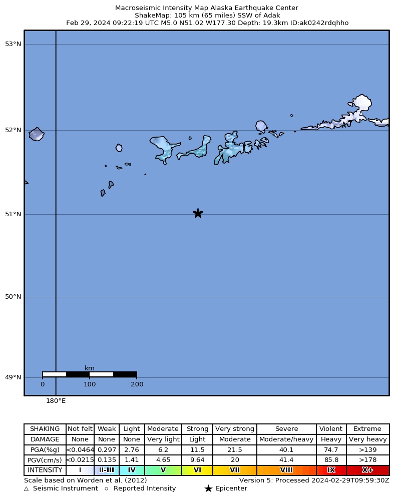
The USGS ShakeMap: shaking estimated from seismic stations and the quake’s size, on the Modified Mercalli intensity scale.
- Strongest estimated
- IV, light shaking
- Peak ground acceleration
- 5.8% of gravity
- Peak ground velocity
- 0.6 cm/s
- Map
- Automatic
Did you feel it?
No one has reported feeling this quake to the USGS.
Fault motion and ground failure
How the rock slipped, from the moment tensor, and the USGS estimate of landslides and liquefaction.
- Faulting
- Reverse (thrust)
- Moment magnitude
- 5.0 Mww
- Nodal plane 1
- Strike 277°, dip 30°, rake 119°
- Nodal plane 2
- Strike 65°, dip 64°, rake 75°
How well it is located
Reviewed by a seismologist.
- Location uncertainty
- About 5.0 km horizontally, 3.9 km in depth
- Magnitude uncertainty
- ±0.07
- Depth from
- From location
- Station coverage gap
- 75°
- Stations used
- 200
Nearby
Within 100 km, magnitude 2.0 and up: 180 in the 60 days after this one and 57 in the 30 days before it.
After
- 2.698 km SW of Adak, Alaska · 944 days ago · 35 km deep · 37 km away
- 3.1129 km WSW of Adak, Alaska · 944 days ago · 35 km deep · 66 km away
- 2.1130 km WSW of Adak, Alaska · 943 days ago · 26 km deep · 71 km away
- 3.846 km S of Adak, Alaska · 942 days ago · 39 km deep · 65 km away
- 2.0127 km WSW of Adak, Alaska · 942 days ago · 20 km deep · 74 km away
- 3.161 km SE of Adak, Alaska · 941 days ago · 35 km deep · 93 km away
- 2.770 km WSW of Adak, Alaska · 941 days ago · 76 km deep · 70 km away
- 2.3102 km SW of Adak, Alaska · 941 days ago · 40 km deep · 41 km away
- 3.061 km SSW of Adak, Alaska · 941 days ago · 35 km deep · 43 km away
- 2.1110 km WSW of Adak, Alaska · 939 days ago · 38 km deep · 66 km away
- 2.7134 km WSW of Adak, Alaska · 939 days ago · 83 km deep · 100 km away
- 2.5133 km SW of Adak, Alaska · 938 days ago · 35 km deep · 63 km away
- 3.068 km SE of Adak, Alaska · 938 days ago · 35 km deep · 97 km away
- 2.765 km SE of Adak, Alaska · 938 days ago · 35 km deep · 97 km away
- 2.167 km SW of Adak, Alaska · 938 days ago · 39 km deep · 49 km away
- 2.573 km SW of Adak, Alaska · 938 days ago · 35 km deep · 37 km away
- 3.652 km S of Adak, Alaska · 937 days ago · 35 km deep · 57 km away
- 2.151 km WSW of Adak, Alaska · 936 days ago · 62 km deep · 82 km away
- 3.041 km S of Adak, Alaska · 936 days ago · 53 km deep · 66 km away
- 2.966 km SE of Adak, Alaska · 936 days ago · 35 km deep · 93 km away
- 2.073 km WSW of Adak, Alaska · 936 days ago · 29 km deep · 57 km away
- 3.975 km S of Adak, Alaska · 936 days ago · 27 km deep · 47 km away
- 2.446 km W of Adak, Alaska · 936 days ago · 124 km deep · 88 km away
- 2.028 km SSE of Adak, Alaska · 936 days ago · 54 km deep · 86 km away
- 2.174 km SW of Adak, Alaska · 935 days ago · 40 km deep · 51 km away
- 2.090 km WSW of Adak, Alaska · 935 days ago · 13 km deep · 61 km away
- 2.693 km SSE of Adak, Alaska · 935 days ago · 31 km deep · 95 km away
- 3.148 km WSW of Adak, Alaska · 935 days ago · 76 km deep · 67 km away
- 3.192 km SSE of Adak, Alaska · 934 days ago · 10 km deep · 95 km away
- 2.9189 km S of Adak, Alaska · 934 days ago · 17 km deep · 100 km away
- 2.1123 km WSW of Adak, Alaska · 934 days ago · 25 km deep · 83 km away
- 2.168 km SE of Adak, Alaska · 934 days ago · 23 km deep · 99 km away
- 2.659 km SE of Adak, Alaska · 933 days ago · 35 km deep · 96 km away
- 2.034 km SW of Adak, Alaska · 932 days ago · 62 km deep · 70 km away
- 2.066 km SW of Adak, Alaska · 932 days ago · 38 km deep · 46 km away
- 2.038 km S of Adak, Alaska · 932 days ago · 38 km deep · 74 km away
- 2.1137 km SW of Adak, Alaska · 931 days ago · 16 km deep · 62 km away
- 2.057 km S of Adak, Alaska · 930 days ago · 23 km deep · 62 km away
- 2.9133 km SW of Adak, Alaska · 930 days ago · 14 km deep · 64 km away
- 3.579 km SSE of Adak, Alaska · 930 days ago · 35 km deep · 77 km away
- 2.2123 km WSW of Adak, Alaska · 929 days ago · 25 km deep · 80 km away
- 2.066 km S of Adak, Alaska · 929 days ago · 26 km deep · 47 km away
- 2.2150 km WSW of Adak, Alaska · 928 days ago · 18 km deep · 85 km away
- 2.0125 km WSW of Adak, Alaska · 928 days ago · 25 km deep · 81 km away
- 2.0125 km WSW of Adak, Alaska · 928 days ago · 7 km deep · 91 km away
- 2.684 km W of Adak, Alaska · 927 days ago · 100 km deep · 93 km away
- 3.4126 km WSW of Adak, Alaska · 926 days ago · 35 km deep · 75 km away
- 3.793 km SW of Adak, Alaska · 926 days ago · 54 km deep · 46 km away
- 2.586 km SSE of Adak, Alaska · 925 days ago · 35 km deep · 74 km away
- 2.178 km SSE of Adak, Alaska · 925 days ago · 22 km deep · 76 km away
- 2.2149 km WSW of Adak, Alaska · 925 days ago · 17 km deep · 98 km away
- 2.751 km SSW of Adak, Alaska · 924 days ago · 35 km deep · 56 km away
- 2.759 km S of Adak, Alaska · 924 days ago · 35 km deep · 50 km away
- 2.743 km S of Adak, Alaska · 922 days ago · 37 km deep · 68 km away
- 2.964 km SSW of Adak, Alaska · 919 days ago · 35 km deep · 39 km away
- 2.262 km SE of Adak, Alaska · 919 days ago · 26 km deep · 98 km away
- 2.1153 km WSW of Adak, Alaska · 917 days ago · 50 km deep · 86 km away
- 3.6157 km WSW of Adak, Alaska · 917 days ago · 35 km deep · 86 km away
- 3.566 km SSE of Adak, Alaska · 917 days ago · 35 km deep · 80 km away
- 2.671 km SSE of Adak, Alaska · 917 days ago · 35 km deep · 77 km away
The first 60 of 180.
Before
- 3.544 km SW of Adak, Alaska · 945 days ago · 71 km deep · 61 km away
- 2.5158 km SW of Adak, Alaska · 945 days ago · 10 km deep · 62 km away
- 2.2127 km WSW of Adak, Alaska · 946 days ago · 24 km deep · 67 km away
- 3.2111 km WSW of Adak, Alaska · 946 days ago · 10 km deep · 73 km away
- 2.3148 km WSW of Adak, Alaska · 947 days ago · 23 km deep · 81 km away
- 2.174 km SW of Adak, Alaska · 949 days ago · 35 km deep · 46 km away
- 2.6134 km WSW of Adak, Alaska · 950 days ago · 31 km deep · 87 km away
- 2.090 km WSW of Adak, Alaska · 950 days ago · 70 km deep · 63 km away
- 2.159 km WSW of Adak, Alaska · 950 days ago · 62 km deep · 62 km away
- 2.078 km SSE of Adak, Alaska · 950 days ago · 25 km deep · 66 km away
- 2.065 km SSW of Adak, Alaska · 951 days ago · 33 km deep · 39 km away
- 2.115 km S of Adak, Alaska · 953 days ago · 62 km deep · 91 km away
- 2.0113 km SW of Adak, Alaska · 953 days ago · 16 km deep · 49 km away
- 2.9144 km WSW of Adak, Alaska · 954 days ago · 35 km deep · 82 km away
- 3.451 km SE of Adak, Alaska · 954 days ago · 35 km deep · 97 km away
- 2.669 km SSW of Adak, Alaska · 955 days ago · 45 km deep · 35 km away
- 3.3136 km WSW of Adak, Alaska · 955 days ago · 35 km deep · 75 km away
- 2.759 km SSE of Adak, Alaska · 955 days ago · 35 km deep · 88 km away
- 2.653 km SSE of Adak, Alaska · 955 days ago · 35 km deep · 71 km away
- 2.641 km S of Adak, Alaska · 955 days ago · 35 km deep · 72 km away
Earthquakes todayAlaska earthquakesLive radar here
Sources
From the USGS Earthquake Hazards Program and its partner networks, event us6000mfsl (also filed as ak0242rdqhho). Read Thu, Oct 1, 2026, 3:35 AM UTC.