M2.7 earthquake 93 km S of Unalaska, Alaska
A magnitude 2.7 earthquake struck 93 km S of Unalaska, Alaska on Tue, Mar 7, 2023, 6:14 PM AKST (03:14 UTC), 20 km (13 mi) below the surface.
A larger quake followed: M3.8 142 km S of Unalaska, Alaska. This one was a foreshock.
Map
Where this earthquake was located, with the others nearby. Select one for its page.
The earthquake
- Magnitude
- 2.7 (ml), micro
- Local time
- UTC
- 2023-03-08 03:14:11 UTC
- Depth
- 20.3 km (12.6 mi), shallow
- Epicenter
- 53.035° N, 166.393° W
- Region
- Alaska
- Strongest shaking
- II, weak shaking
- Tsunami flag
- No
- Status
- Reviewed by a seismologist
Shaking
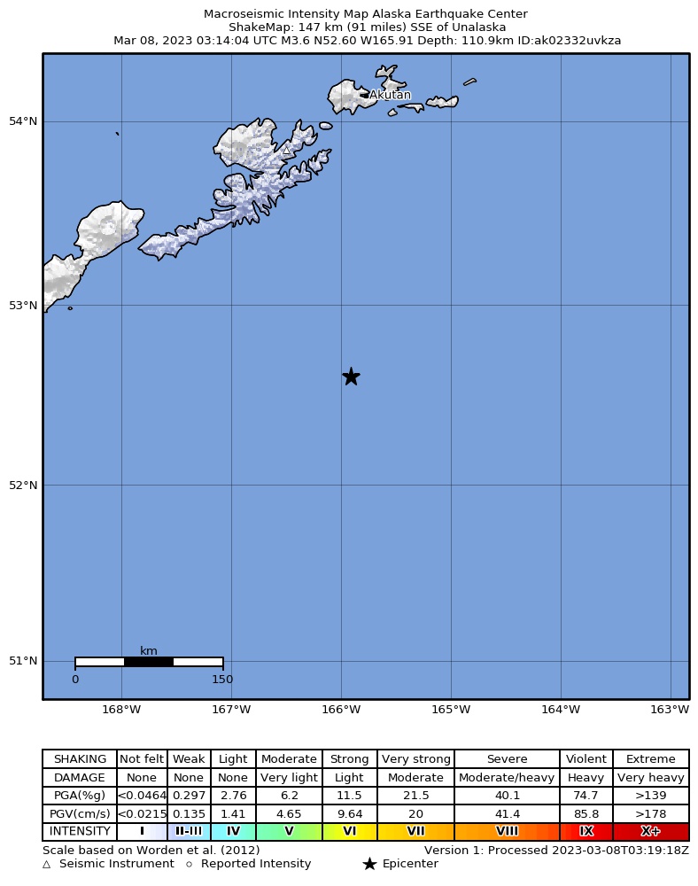
The USGS ShakeMap: shaking estimated from seismic stations and the quake’s size, on the Modified Mercalli intensity scale.
- Strongest estimated
- II, weak shaking
- Peak ground acceleration
- 0.0% of gravity
- Peak ground velocity
- -5.0 cm/s
- Map
- Automatic
Did you feel it?
No one has reported feeling this quake to the USGS.
How well it is located
Reviewed by a seismologist.
- Location uncertainty
- About 3.4 km horizontally, 12.8 km in depth
- Magnitude uncertainty
- ±0.10
- Depth from
- From location
- Station coverage gap
- 226°, poorly surrounded by stations
- Stations used
- 28
Nearest places
Distance and direction from each place to the epicenter, with its forecast.
Nearby
Within 100 km, magnitude 1.5 and up: at least 199 in the 60 days after this one and 55 in the 30 days before it.
After
- 3.8142 km S of Unalaska, Alaska · 1302 days ago · 25 km deep · 49 km away
- 2.5147 km S of Unalaska, Alaska · 1302 days ago · 26 km deep · 54 km away
- 2.0129 km ESE of Nikolski, Alaska · 1302 days ago · 13 km deep · 60 km away
- 3.3118 km ESE of Nikolski, Alaska · 1302 days ago · 35 km deep · 74 km away
- 1.873 km WSW of Unalaska, Alaska · 1302 days ago · 13 km deep · 98 km away
- 2.626 km SSW of Unalaska, Alaska · 1302 days ago · 84 km deep · 72 km away
- 2.781 km ESE of Nikolski, Alaska · 1301 days ago · 35 km deep · 91 km away
- 2.979 km SSE of Unalaska, Alaska · 1300 days ago · 35 km deep · 32 km away
- 1.872 km SSE of Unalaska, Alaska · 1300 days ago · 42 km deep · 39 km away
- 1.880 km SSE of Akutan, Alaska · 1300 days ago · 17 km deep · 93 km away
- 1.742 km S of Unalaska, Alaska · 1300 days ago · 72 km deep · 51 km away
- 2.348 km ESE of Unalaska, Alaska · 1300 days ago · 42 km deep · 81 km away
- 1.571 km SSE of Akutan, Alaska · 1299 days ago · 25 km deep · 87 km away
- 1.674 km SSE of Akutan, Alaska · 1299 days ago · 50 km deep · 87 km away
- 2.771 km ENE of Nikolski, Alaska · 1299 days ago · 54 km deep · 98 km away
- 3.4Fox Islands, Aleutian Islands, Alaska · 1298 days ago · 35 km deep · 68 km away
- 2.181 km E of Nikolski, Alaska · 1298 days ago · 22 km deep · 89 km away
- 2.379 km SSE of Akutan, Alaska · 1297 days ago · 26 km deep · 81 km away
- 2.070 km SE of Unalaska, Alaska · 1297 days ago · 21 km deep · 51 km away
- 2.170 km SSW of Unalaska, Alaska · 1296 days ago · 47 km deep · 42 km away
- 2.176 km SW of Unalaska, Alaska · 1296 days ago · 13 km deep · 82 km away
- 2.6Fox Islands, Aleutian Islands, Alaska · 1295 days ago · 10 km deep · 56 km away
- 2.890 km ENE of Nikolski, Alaska · 1295 days ago · 80 km deep · 98 km away
- 2.3116 km ESE of Nikolski, Alaska · 1294 days ago · 22 km deep · 93 km away
- 3.481 km S of Unalaska, Alaska · 1294 days ago · 35 km deep · 25 km away
- 2.2Fox Islands, Aleutian Islands, Alaska · 1294 days ago · 26 km deep · 26 km away
- 2.062 km SE of Unalaska, Alaska · 1292 days ago · 41 km deep · 64 km away
- 1.669 km SE of Unalaska, Alaska · 1291 days ago · 25 km deep · 68 km away
- 1.659 km SE of Unalaska, Alaska · 1291 days ago · 39 km deep · 69 km away
- 1.513 km WSW of Unalaska, Alaska · 1291 days ago · 10 km deep · 90 km away
- 2.225 km SSW of Unalaska, Alaska · 1290 days ago · 71 km deep · 73 km away
- 2.265 km SE of Unalaska, Alaska · 1288 days ago · 26 km deep · 60 km away
- 2.5Fox Islands, Aleutian Islands, Alaska · 1287 days ago · 35 km deep · 32 km away
- 2.0137 km S of Unalaska, Alaska · 1287 days ago · 26 km deep · 47 km away
- 2.729 km ESE of Unalaska, Alaska · 1286 days ago · 73 km deep · 87 km away
- 2.365 km SW of Unalaska, Alaska · 1286 days ago · 70 km deep · 73 km away
- 3.780 km S of Unalaska, Alaska · 1286 days ago · 36 km deep · 27 km away
- 2.269 km SW of Unalaska, Alaska · 1286 days ago · 102 km deep · 81 km away
- 2.120 km SSE of Unalaska, Alaska · 1284 days ago · 79 km deep · 73 km away
- 2.54 km SW of Unalaska, Alaska · 1284 days ago · 9 km deep · 90 km away
- 2.234 km SW of Unalaska, Alaska · 1284 days ago · 107 km deep · 79 km away
- 1.52 km WSW of Dutch Harbor, Alaska · 1284 days ago · 7 km deep · 95 km away
- 1.53 km WSW of Dutch Harbor, Alaska · 1284 days ago · 6 km deep · 95 km away
- 2.23 km W of Dutch Harbor, Alaska · 1284 days ago · 5 km deep · 95 km away
- 2.21 km WSW of Dutch Harbor, Alaska · 1284 days ago · 5 km deep · 95 km away
- 1.52 km WSW of Dutch Harbor, Alaska · 1284 days ago · 5 km deep · 95 km away
- 2.73 km SW of Unalaska, Alaska · 1283 days ago · 8 km deep · 91 km away
- 1.73 km WSW of Unalaska, Alaska · 1283 days ago · 4 km deep · 92 km away
- 2.03 km WSW of Dutch Harbor, Alaska · 1283 days ago · 6 km deep · 94 km away
- 1.8Fox Islands, Aleutian Islands, Alaska · 1283 days ago · 5 km deep · 93 km away
- 2.14 km WSW of Dutch Harbor, Alaska · 1283 days ago · 5 km deep · 95 km away
- 1.898 km E of Nikolski, Alaska · 1283 days ago · 26 km deep · 68 km away
- 1.679 km S of Unalaska, Alaska · 1283 days ago · 26 km deep · 26 km away
- 1.669 km SE of Unalaska, Alaska · 1283 days ago · 29 km deep · 52 km away
- 1.766 km SE of Unalaska, Alaska · 1283 days ago · 30 km deep · 50 km away
- 1.974 km SSE of Akutan, Alaska · 1282 days ago · 24 km deep · 83 km away
- 1.6Fox Islands, Aleutian Islands, Alaska · 1282 days ago · 27 km deep · 50 km away
- 1.82 km W of Unalaska, Alaska · 1281 days ago · 6 km deep · 94 km away
- 1.91 km W of Unalaska, Alaska · 1281 days ago · 5 km deep · 94 km away
- 1.63 km W of Unalaska, Alaska · 1281 days ago · 7 km deep · 94 km away
The first 60 of at least 199.
Before
- 2.867 km SE of Unalaska, Alaska · 1305 days ago · 35 km deep · 64 km away
- 1.966 km SE of Unalaska, Alaska · 1305 days ago · 22 km deep · 65 km away
- 2.554 km SW of Unalaska, Alaska · 1307 days ago · 9 km deep · 63 km away
- 2.7Fox Islands, Aleutian Islands, Alaska · 1307 days ago · 10 km deep · 57 km away
- 1.549 km SW of Unalaska, Alaska · 1307 days ago · 9 km deep · 78 km away
- 2.171 km SSE of Akutan, Alaska · 1308 days ago · 55 km deep · 91 km away
- 3.242 km SW of Unalaska, Alaska · 1309 days ago · 80 km deep · 71 km away
- 2.5Fox Islands, Aleutian Islands, Alaska · 1310 days ago · 35 km deep · 88 km away
- 2.884 km SSW of Unalaska, Alaska · 1310 days ago · 35 km deep · 36 km away
- 1.981 km SSW of Unalaska, Alaska · 1310 days ago · 18 km deep · 42 km away
- 1.930 km SSW of Akutan, Alaska · 1311 days ago · 72 km deep · 99 km away
- 1.647 km WSW of Unalaska, Alaska · 1311 days ago · 15 km deep · 86 km away
- 3.6102 km SSE of Akutan, Alaska · 1313 days ago · 35 km deep · 90 km away
- 2.945 km SSE of Unalaska, Alaska · 1314 days ago · 66 km deep · 55 km away
- 1.971 km SSE of Akutan, Alaska · 1314 days ago · 18 km deep · 91 km away
- 2.054 km SSE of Akutan, Alaska · 1315 days ago · 79 km deep · 97 km away
- 2.078 km SSE of Akutan, Alaska · 1315 days ago · 37 km deep · 89 km away
- 1.955 km S of Unalaska, Alaska · 1315 days ago · 55 km deep · 39 km away
- 2.5129 km ESE of Nikolski, Alaska · 1316 days ago · 10 km deep · 70 km away
- 2.724 km SE of Unalaska, Alaska · 1316 days ago · 80 km deep · 76 km away
Earthquakes todayAlaska earthquakesLive radar here
Sources
From the USGS Earthquake Hazards Program and its partner networks, event us7000ji1x (also filed as ak02332uvkza). Read Thu, Oct 1, 2026, 2:25 AM UTC.