M5.0 earthquake 59 km N of Karluk, Alaska
A magnitude 5.0 earthquake struck 59 km N of Karluk, Alaska on Sun, Jun 18, 2023, 1:14 AM AKDT (09:14 UTC), 84 km (52 mi) below the surface.
Map
Where this earthquake was located, with the others nearby. Select one for its page.
The earthquake
- Magnitude
- 5.0 (Mww, W-phase moment), moderate
- Magnitude from
- Alaska Earthquake Center
- Local time
- UTC
- 2023-06-18 09:14:31 UTC
- Depth
- 84.2 km (52.3 mi), intermediate-depth
- Epicenter
- 58.102° N, 154.603° W
- Region
- Alaska
- Felt reports
- 66
- Strongest shaking
- IV, light shaking
- Tsunami flag
- Yes: a large quake in an oceanic region
- Status
- Reviewed by a seismologist
Magnitude estimates
Different scales measure different things and differ by a few tenths. The USGS marks one as preferred, and it is the one this page uses.
| Mag. | Scale | Computed by | Notes |
|---|---|---|---|
| 5.0 | Mww, W-phase moment | Alaska Earthquake Center | Preferred · Preliminary |
| 5.0 | Mww, W-phase moment | USGS National Earthquake Information Center | Reviewed · ±0.036 · 76 stations |
| 5.0 | ML, local (Richter) | NOAA National Tsunami Warning Center | Reviewed · 39 stations |
| 5.0 | Mwr, regional moment | USGS National Earthquake Information Center | Moment tensor · Reviewed |
Tsunami
The USGS flags a quake this large in an oceanic region. The flag does not mean a tsunami happened; the tsunami warning centers decide that, and their messages are below when they issued any.
Current tsunami warnings: tsunami.gov. Warnings in force in the US also appear on our alerts pages.
Shaking
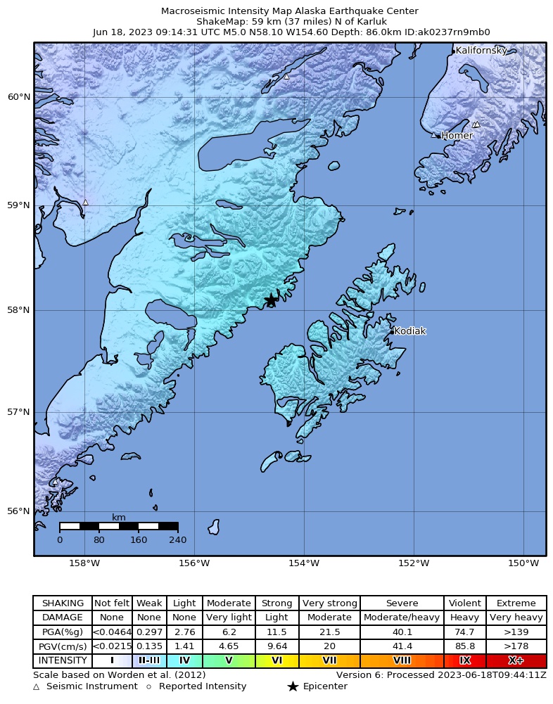
The USGS ShakeMap: shaking estimated from seismic stations and the quake’s size, on the Modified Mercalli intensity scale.
- Strongest estimated
- IV, light shaking
- Peak ground acceleration
- 1.4% of gravity
- Peak ground velocity
- -1.1 cm/s
- Map
- Automatic
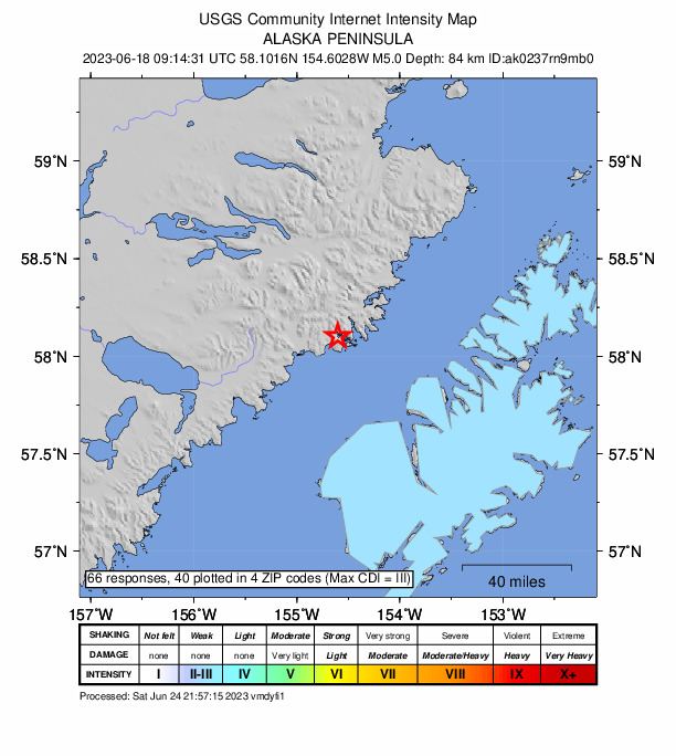
Did you feel it?
66 people reported to the USGS what they felt; the strongest reported shaking was IV, light shaking.
Fault motion and ground failure
How the rock slipped, from the moment tensor, and the USGS estimate of landslides and liquefaction.
- Faulting
- Strike-slip
- Moment magnitude
- 5.0 Mww
- Nodal plane 1
- Strike 343°, dip 56°, rake 154°
- Nodal plane 2
- Strike 88°, dip 68°, rake 37°
How well it is located
Reviewed by a seismologist.
- Stations used
- 223
Nearest places
Distance and direction from each place to the epicenter, with its forecast.
Nearby
Within 100 km, magnitude 2.0 and up: 104 in the 60 days after this one and 39 in the 30 days before it.
After
- 2.358 km WSW of Karluk, Alaska · 1202 days ago · 72 km deep · 96 km away
- 2.384 km NNW of Karluk, Alaska · 1201 days ago · 1 km deep · 29 km away
- 3.134 km SW of Karluk, Alaska · 1200 days ago · 19 km deep · 87 km away
- 2.073 km SE of Kokhanok, Alaska · 1196 days ago · 97 km deep · 98 km away
- 2.629 km WNW of Karluk, Alaska · 1195 days ago · 63 km deep · 55 km away
- 2.461 km SSE of Igiugig, Alaska · 1195 days ago · 160 km deep · 95 km away
- 2.1Kodiak Island region, Alaska · 1195 days ago · 11 km deep · 66 km away
- 2.134 km E of Larsen Bay, Alaska · 1194 days ago · 1 km deep · 92 km away
- 2.551 km ESE of King Salmon, Alaska · 1193 days ago · 158 km deep · 86 km away
- 2.182 km NNW of Karluk, Alaska · 1193 days ago · 40 km deep · 32 km away
- 2.185 km SE of King Salmon, Alaska · 1192 days ago · 119 km deep · 67 km away
- 2.868 km NNW of Karluk, Alaska · 1192 days ago · 94 km deep · 13 km away
- 2.322 km SW of Larsen Bay, Alaska · 1192 days ago · 43 km deep · 84 km away
- 2.064 km SE of King Salmon, Alaska · 1192 days ago · 148 km deep · 82 km away
- 2.0Alaska Peninsula · 1190 days ago · 5 km deep · 46 km away
- 2.359 km N of Karluk, Alaska · 1189 days ago · 86 km deep · 0 km away · felt by 1
- 2.289 km WNW of Karluk, Alaska · 1188 days ago · 1 km deep · 87 km away
- 4.2Alaska Peninsula · 1188 days ago · 13 km deep · 88 km away · felt by 1
- 2.489 km WNW of Karluk, Alaska · 1188 days ago · 11 km deep · 87 km away
- 2.688 km WNW of Karluk, Alaska · 1188 days ago · 4 km deep · 87 km away
- 2.190 km WNW of Karluk, Alaska · 1188 days ago · 9 km deep · 88 km away
- 2.691 km WNW of Karluk, Alaska · 1188 days ago · 12 km deep · 87 km away
- 2.789 km WNW of Karluk, Alaska · 1188 days ago · 9 km deep · 86 km away
- 2.090 km WNW of Karluk, Alaska · 1188 days ago · 8 km deep · 88 km away
- 2.086 km W of Karluk, Alaska · 1188 days ago · 4 km deep · 86 km away
- 2.090 km WNW of Karluk, Alaska · 1188 days ago · 2 km deep · 88 km away
- 2.4Alaska Peninsula · 1188 days ago · 0 km deep · 86 km away
- 2.391 km WNW of Karluk, Alaska · 1188 days ago · 10 km deep · 87 km away
- 2.755 km ESE of King Salmon, Alaska · 1187 days ago · 144 km deep · 82 km away · felt by 1
- 2.082 km NW of Karluk, Alaska · 1187 days ago · 1 km deep · 43 km away
- 2.883 km NW of Karluk, Alaska · 1187 days ago · 2 km deep · 40 km away
- 2.190 km WNW of Karluk, Alaska · 1187 days ago · 12 km deep · 89 km away
- 2.590 km WNW of Karluk, Alaska · 1187 days ago · 12 km deep · 88 km away
- 2.3Alaska Peninsula · 1186 days ago · 8 km deep · 84 km away
- 2.283 km SSE of Kokhanok, Alaska · 1186 days ago · 98 km deep · 74 km away
- 2.185 km NW of Karluk, Alaska · 1186 days ago · 2 km deep · 42 km away
- 2.269 km NNW of Aleneva, Alaska · 1186 days ago · 82 km deep · 85 km away
- 2.191 km WNW of Aleneva, Alaska · 1186 days ago · 92 km deep · 49 km away
- 2.490 km ENE of Ugashik, Alaska · 1185 days ago · 8 km deep · 88 km away · felt by 1
- 2.286 km NW of Karluk, Alaska · 1185 days ago · 5 km deep · 46 km away
- 2.072 km SE of King Salmon, Alaska · 1184 days ago · 132 km deep · 77 km away
- 2.2Alaska Peninsula · 1184 days ago · 1 km deep · 37 km away
- 2.014 km NNE of Karluk, Alaska · 1182 days ago · 51 km deep · 47 km away
- 2.169 km N of Karluk, Alaska · 1182 days ago · 88 km deep · 9 km away
- 2.486 km NW of Karluk, Alaska · 1182 days ago · 3 km deep · 43 km away
- 2.189 km WNW of Karluk, Alaska · 1181 days ago · 11 km deep · 87 km away
- 3.731 km WNW of Karluk, Alaska · 1181 days ago · 71 km deep · 49 km away
- 2.684 km NW of Karluk, Alaska · 1180 days ago · 5 km deep · 40 km away
- 2.486 km NW of Karluk, Alaska · 1180 days ago · 1 km deep · 46 km away
- 2.2Alaska Peninsula · 1180 days ago · 3 km deep · 46 km away
- 2.192 km WNW of Karluk, Alaska · 1180 days ago · 6 km deep · 85 km away
- 2.086 km NW of Karluk, Alaska · 1180 days ago · 3 km deep · 45 km away
- 2.180 km SSE of Kokhanok, Alaska · 1179 days ago · 90 km deep · 76 km away
- 2.0Alaska Peninsula · 1177 days ago · 155 km deep · 85 km away
- 2.368 km SE of Kokhanok, Alaska · 1176 days ago · 103 km deep · 98 km away
- 2.417 km SSW of Larsen Bay, Alaska · 1176 days ago · 65 km deep · 86 km away
- 2.091 km WNW of Karluk, Alaska · 1175 days ago · 9 km deep · 86 km away
- 2.489 km WNW of Karluk, Alaska · 1175 days ago · 5 km deep · 84 km away
- 2.185 km NNW of Karluk, Alaska · 1174 days ago · 2 km deep · 36 km away
- 2.564 km S of Kokhanok, Alaska · 1173 days ago · 116 km deep · 85 km away
The first 60 of 104.
Before
- 2.986 km NNW of Karluk, Alaska · 1204 days ago · 1 km deep · 34 km away
- 2.038 km N of Karluk, Alaska · 1207 days ago · 52 km deep · 27 km away
- 2.086 km NW of Karluk, Alaska · 1207 days ago · 6 km deep · 46 km away
- 2.648 km SW of Karluk, Alaska · 1209 days ago · 47 km deep · 96 km away
- 2.5Alaska Peninsula · 1209 days ago · 106 km deep · 48 km away
- 3.347 km W of Aleneva, Alaska · 1210 days ago · 60 km deep · 53 km away
- 2.486 km E of King Salmon, Alaska · 1210 days ago · 137 km deep · 67 km away
- 2.087 km NW of Karluk, Alaska · 1211 days ago · 3 km deep · 46 km away
- 3.686 km NNW of Karluk, Alaska · 1211 days ago · 5 km deep · 35 km away
- 2.9Alaska Peninsula · 1211 days ago · 1 km deep · 34 km away
- 2.159 km SE of King Salmon, Alaska · 1212 days ago · 156 km deep · 84 km away
- 2.985 km NNW of Karluk, Alaska · 1215 days ago · 2 km deep · 35 km away · felt by 1
- 2.584 km NW of Karluk, Alaska · 1215 days ago · 2 km deep · 40 km away
- 2.337 km NNE of Larsen Bay, Alaska · 1215 days ago · 37 km deep · 52 km away
- 2.222 km WSW of Port Lions, Alaska · 1216 days ago · 44 km deep · 86 km away
- 2.279 km ESE of Egegik, Alaska · 1216 days ago · 129 km deep · 93 km away
- 3.1Alaska Peninsula · 1217 days ago · 3 km deep · 36 km away
- 2.511 km W of Aleneva, Alaska · 1217 days ago · 54 km deep · 88 km away
- 2.619 km SSW of Larsen Bay, Alaska · 1218 days ago · 44 km deep · 85 km away · felt by 1
- 2.384 km ESE of King Salmon, Alaska · 1221 days ago · 124 km deep · 53 km away
Earthquakes todayAlaska earthquakesLive radar here
Sources
From the USGS Earthquake Hazards Program and its partner networks, event ak0237rn9mb0 (also filed as at00rwfz06, us7000k9bv). Read Sat, Oct 3, 2026, 4:25 AM UTC.