M4.6 earthquake 150 km S of False Pass, Alaska
A magnitude 4.6 earthquake struck 150 km S of False Pass, Alaska on Mon, Dec 25, 2023, 8:32 AM AKST (17:32 UTC), 23 km (14 mi) below the surface.
Map
Where this earthquake was located, with the others nearby. Select one for its page.
The earthquake
- Magnitude
- 4.6 (mwr), light
- Local time
- UTC
- 2023-12-25 17:32:35 UTC
- Depth
- 22.9 km (14.2 mi), shallow
- Epicenter
- 53.499° N, 163.453° W
- Region
- Alaska
- Strongest shaking
- II, weak shaking
- Tsunami flag
- No
- Status
- Reviewed by a seismologist
Shaking
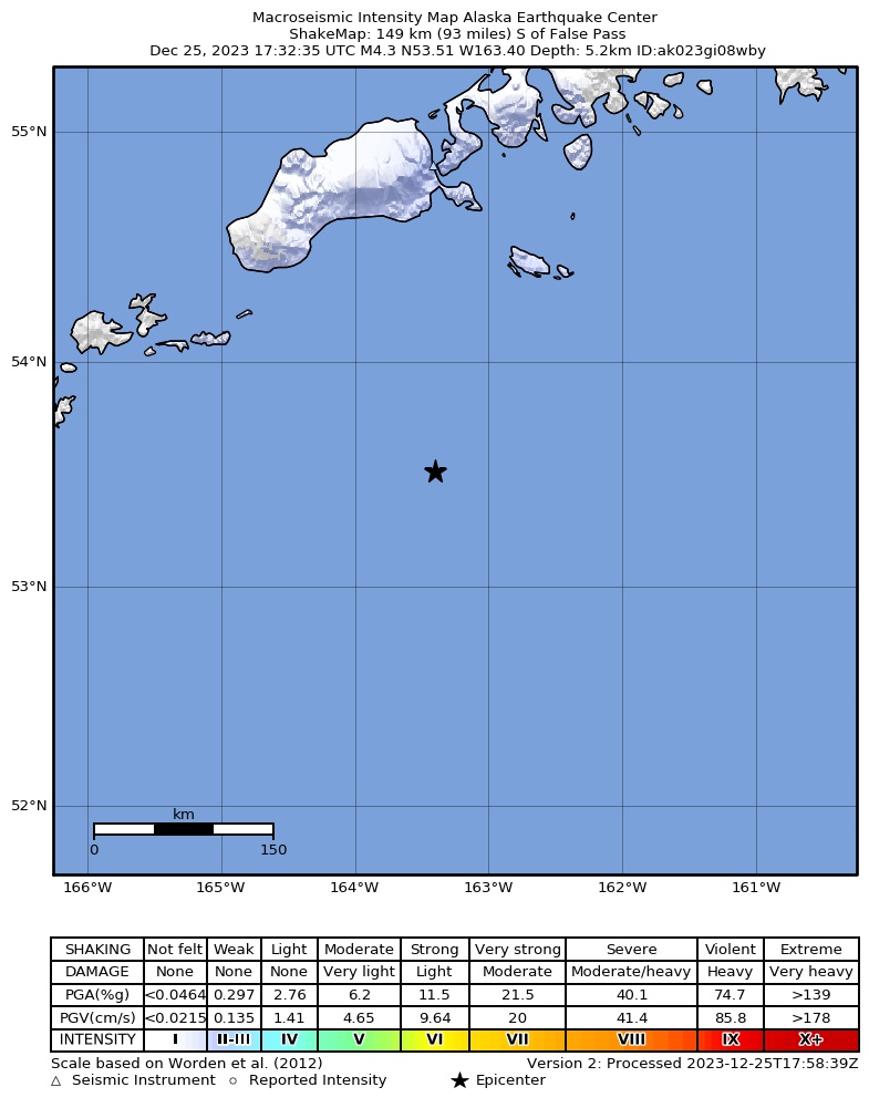
The USGS ShakeMap: shaking estimated from seismic stations and the quake’s size, on the Modified Mercalli intensity scale.
- Strongest estimated
- II, weak shaking
- Peak ground acceleration
- 0.1% of gravity
- Peak ground velocity
- -2.6 cm/s
- Map
- Automatic
Did you feel it?
No one has reported feeling this quake to the USGS.
Fault motion and ground failure
How the rock slipped, from the moment tensor, and the USGS estimate of landslides and liquefaction.
- Faulting
- Strike-slip
- Moment magnitude
- 4.6 Mwr
- Nodal plane 1
- Strike 145°, dip 44°, rake 6°
- Nodal plane 2
- Strike 50°, dip 86°, rake 134°
How well it is located
Reviewed by a seismologist.
- Location uncertainty
- About 4.0 km horizontally, 5.2 km in depth
- Magnitude uncertainty
- ±0.07
- Depth from
- From location
- Station coverage gap
- 135°
- Stations used
- 81
Nearest places
Distance and direction from each place to the epicenter, with its forecast.
Nearby
Within 100 km, magnitude 1.6 and up: 79 in the 60 days after this one and 37 in the 30 days before it.
After
- 2.5142 km S of False Pass, Alaska · 1008 days ago · 33 km deep · 8 km away
- 2.287 km S of False Pass, Alaska · 1007 days ago · 20 km deep · 64 km away
- 2.179 km E of Akutan, Alaska · 1007 days ago · 17 km deep · 95 km away
- 2.6156 km S of False Pass, Alaska · 1007 days ago · 10 km deep · 6 km away
- 3.0134 km SE of Akutan, Alaska · 1006 days ago · 10 km deep · 84 km away
- 1.874 km SE of Akutan, Alaska · 1005 days ago · 43 km deep · 98 km away
- 2.8212 km SSE of False Pass, Alaska · 1005 days ago · 10 km deep · 95 km away
- 2.6111 km ESE of Akutan, Alaska · 1004 days ago · 30 km deep · 57 km away
- 3.188 km SE of Akutan, Alaska · 1002 days ago · 35 km deep · 83 km away
- 2.379 km S of False Pass, Alaska · 1001 days ago · 80 km deep · 72 km away
- 2.581 km S of False Pass, Alaska · 1000 days ago · 83 km deep · 71 km away
- 3.2202 km SE of Akutan, Alaska · 999 days ago · 10 km deep · 95 km away
- 3.1109 km SE of Akutan, Alaska · 999 days ago · 35 km deep · 75 km away
- 3.097 km SE of Akutan, Alaska · 997 days ago · 35 km deep · 80 km away
- 3.8140 km S of False Pass, Alaska · 995 days ago · 35 km deep · 11 km away
- 2.483 km E of Akutan, Alaska · 994 days ago · 63 km deep · 92 km away
- 3.0104 km ESE of Akutan, Alaska · 991 days ago · 28 km deep · 64 km away
- 3.3154 km S of False Pass, Alaska · 990 days ago · 29 km deep · 4 km away
- 2.9153 km S of False Pass, Alaska · 990 days ago · 29 km deep · 3 km away
- 2.4126 km SSW of False Pass, Alaska · 990 days ago · 26 km deep · 40 km away
- 2.9164 km S of False Pass, Alaska · 988 days ago · 10 km deep · 14 km away
- 2.6156 km S of False Pass, Alaska · 987 days ago · 10 km deep · 8 km away
- 2.7158 km S of False Pass, Alaska · 987 days ago · 10 km deep · 11 km away
- 2.9143 km SE of Akutan, Alaska · 987 days ago · 35 km deep · 51 km away
- 2.8114 km ESE of Akutan, Alaska · 987 days ago · 30 km deep · 56 km away
- 3.285 km ESE of Akutan, Alaska · 986 days ago · 35 km deep · 83 km away
- 2.6156 km S of False Pass, Alaska · 986 days ago · 10 km deep · 9 km away
- 2.5119 km SSW of False Pass, Alaska · 986 days ago · 35 km deep · 52 km away
- 2.7149 km S of False Pass, Alaska · 984 days ago · 35 km deep · 2 km away
- 2.184 km S of False Pass, Alaska · 984 days ago · 4 km deep · 71 km away
- 3.2105 km ESE of Akutan, Alaska · 984 days ago · 35 km deep · 63 km away
- 2.9100 km E of Akutan, Alaska · 981 days ago · 35 km deep · 75 km away
- 2.4105 km ESE of Akutan, Alaska · 981 days ago · 35 km deep · 65 km away
- 3.1115 km ESE of Akutan, Alaska · 980 days ago · 32 km deep · 53 km away
- 2.1103 km SSW of False Pass, Alaska · 978 days ago · 26 km deep · 65 km away
- 1.955 km SSE of False Pass, Alaska · 978 days ago · 62 km deep · 100 km away
- 1.892 km S of False Pass, Alaska · 977 days ago · 26 km deep · 61 km away
- 2.9156 km S of False Pass, Alaska · 977 days ago · 35 km deep · 11 km away
- 2.1105 km ESE of Akutan, Alaska · 977 days ago · 25 km deep · 64 km away
- 2.3111 km SSE of False Pass, Alaska · 975 days ago · 25 km deep · 63 km away
- 2.5108 km ESE of Akutan, Alaska · 974 days ago · 35 km deep · 60 km away
- 2.295 km ESE of Akutan, Alaska · 974 days ago · 38 km deep · 72 km away
- 2.788 km SSW of False Pass, Alaska · 974 days ago · 35 km deep · 88 km away
- 2.183 km SSW of False Pass, Alaska · 974 days ago · 69 km deep · 84 km away
- 2.3138 km SE of Akutan, Alaska · 973 days ago · 17 km deep · 82 km away
- 2.7102 km S of King Cove, Alaska · 973 days ago · 10 km deep · 100 km away
- 2.691 km SE of Akutan, Alaska · 973 days ago · 35 km deep · 100 km away
- 2.2137 km S of False Pass, Alaska · 970 days ago · 12 km deep · 17 km away
- 3.4155 km S of False Pass, Alaska · 970 days ago · 35 km deep · 7 km away
- 2.585 km SE of False Pass, Alaska · 969 days ago · 18 km deep · 97 km away
- 2.9215 km S of False Pass, Alaska · 967 days ago · 10 km deep · 71 km away
- 2.584 km ESE of Akutan, Alaska · 966 days ago · 35 km deep · 88 km away
- 3.1103 km ESE of Akutan, Alaska · 965 days ago · 35 km deep · 65 km away
- 2.288 km S of False Pass, Alaska · 963 days ago · 19 km deep · 62 km away
- 2.5109 km SSW of False Pass, Alaska · 963 days ago · 35 km deep · 60 km away
- 3.0225 km SE of Akutan, Alaska · 963 days ago · 10 km deep · 93 km away
- 2.9117 km ESE of Akutan, Alaska · 963 days ago · 35 km deep · 53 km away
- 2.772 km ESE of Akutan, Alaska · 963 days ago · 67 km deep · 97 km away
- 2.9111 km SE of Akutan, Alaska · 962 days ago · 13 km deep · 93 km away
- 2.174 km S of False Pass, Alaska · 959 days ago · 26 km deep · 76 km away
The first 60 of 79.
Before
- 2.3107 km S of False Pass, Alaska · 1008 days ago · 25 km deep · 45 km away
- 2.298 km SSE of False Pass, Alaska · 1008 days ago · 24 km deep · 83 km away
- 2.4131 km SE of Akutan, Alaska · 1009 days ago · 23 km deep · 78 km away
- 2.8107 km S of False Pass, Alaska · 1010 days ago · 35 km deep · 46 km away
- 4.089 km SSW of False Pass, Alaska · 1012 days ago · 38 km deep · 66 km away
- 2.498 km S of False Pass, Alaska · 1012 days ago · 26 km deep · 53 km away
- 3.0155 km S of False Pass, Alaska · 1012 days ago · 28 km deep · 13 km away
- 3.3165 km S of False Pass, Alaska · 1012 days ago · 35 km deep · 16 km away
- 2.6128 km SE of Akutan, Alaska · 1013 days ago · 30 km deep · 46 km away
- 2.1113 km ESE of Akutan, Alaska · 1015 days ago · 26 km deep · 56 km away
- 2.2110 km SSW of False Pass, Alaska · 1015 days ago · 42 km deep · 60 km away
- 2.7160 km S of False Pass, Alaska · 1015 days ago · 35 km deep · 10 km away
- 2.576 km S of False Pass, Alaska · 1016 days ago · 35 km deep · 75 km away
- 3.4159 km S of False Pass, Alaska · 1017 days ago · 10 km deep · 10 km away
- 2.6121 km ESE of Akutan, Alaska · 1017 days ago · 35 km deep · 49 km away
- 2.3113 km ESE of Akutan, Alaska · 1018 days ago · 26 km deep · 57 km away
- 2.8115 km ESE of Akutan, Alaska · 1018 days ago · 30 km deep · 53 km away
- 2.8174 km SE of Akutan, Alaska · 1021 days ago · 10 km deep · 28 km away
- 2.496 km SSW of False Pass, Alaska · 1021 days ago · 26 km deep · 70 km away
- 2.5102 km S of False Pass, Alaska · 1023 days ago · 35 km deep · 50 km away
Earthquakes todayAlaska earthquakesLive radar here
Sources
From the USGS Earthquake Hazards Program and its partner networks, event us7000lldz (also filed as ak023gi08wby). Read Mon, Sep 28, 2026, 6:40 AM UTC.