M1.5 earthquake Colorado
A magnitude 1.5 earthquake struck in Colorado on Wed, Sep 20, 2023, 5:33 AM MDT (11:33 UTC), 5 km (3 mi) below the surface.
A larger quake followed: M2.8 7 km NNW of El Moro, Colorado. This one was a foreshock.
Map
Where this earthquake was located, with the others nearby. Select one for its page.
The earthquake
- Magnitude
- 1.5 (ML, local (Richter)), micro
- Magnitude from
- USGS National Earthquake Information Center
- Local time
- UTC
- 2023-09-20 11:33:47 UTC
- Depth
- 5.0 km (3.1 mi), shallow
- Epicenter
- 37.276° N, 104.494° W
- Region
- Colorado
- Felt reports
- 1
- Tsunami flag
- No
- Status
- Reviewed by a seismologist
Did you feel it?
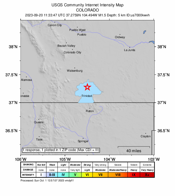
1 person reported to the USGS what they felt; the strongest reported shaking was III, weak shaking.
How well it is located
Reviewed by a seismologist.
- Location uncertainty
- About 1.6 km horizontally, 1.6 km in depth
- Magnitude uncertainty
- ±0.13
- Depth from
- Operator assigned
- Station coverage gap
- 72°
- Stations used
- 9
Nearest places
Distance and direction from each place to the epicenter, with its forecast.
Nearby
Within 100 km, magnitude 1.5 and up: 25 in the 60 days after this one and 49 in the 30 days before it.
After
- 2.87 km NNW of El Moro, Colorado · 1109 days ago · 5 km deep · 2 km away · felt by 8
- 1.69 km WNW of Hoehne, Colorado · 1109 days ago · 5 km deep · 4 km away
- 1.6Colorado · 1109 days ago · 6 km deep · 4 km away
- 2.2Colorado · 1106 days ago · 5 km deep · 35 km away
- 1.510 km SSE of Walsenburg, Colorado · 1103 days ago · 5 km deep · 36 km away
- 1.613 km ENE of Colorado City, Colorado · 1100 days ago · 5 km deep · 79 km away
- 1.612 km S of Weston, Colorado · 1098 days ago · 5 km deep · 43 km away
- 1.923 km S of Weston, Colorado · 1097 days ago · 5 km deep · 51 km away
- 1.711 km SSE of Walsenburg, Colorado · 1095 days ago · 5 km deep · 35 km away
- 1.710 km SE of Walsenburg, Colorado · 1094 days ago · 5 km deep · 35 km away
- 1.515 km SSW of Weston, Colorado · 1092 days ago · 5 km deep · 47 km away
- 1.513 km S of Stonewall Gap, Colorado · 1087 days ago · 5 km deep · 53 km away
- 1.76 km WNW of Hoehne, Colorado · 1087 days ago · 5 km deep · 4 km away
- 1.711 km NE of Stonewall Gap, Colorado · 1085 days ago · 5 km deep · 40 km away
- 2.89 km NNW of El Moro, Colorado · 1083 days ago · 5 km deep · 3 km away · felt by 4
- 1.534 km NNE of Cimarron, New Mexico · 1072 days ago · 5 km deep · 59 km away
- 2.016 km SW of Weston, Colorado · 1070 days ago · 5 km deep · 51 km away
- 2.017 km S of Weston, Colorado · 1065 days ago · 5 km deep · 46 km away
- 1.618 km S of Weston, Colorado · 1065 days ago · 5 km deep · 46 km away
- 2.126 km SSW of Segundo, Colorado · 1061 days ago · 5 km deep · 52 km away
- 2.026 km SSW of Segundo, Colorado · 1060 days ago · 5 km deep · 52 km away
- 1.825 km S of Weston, Colorado · 1060 days ago · 5 km deep · 52 km away
- 2.126 km S of Weston, Colorado · 1060 days ago · 5 km deep · 52 km away
- 1.67 km WNW of Hoehne, Colorado · 1060 days ago · 5 km deep · 3 km away
- 2.032 km S of Weston, Colorado · 1052 days ago · 5 km deep · 58 km away
Before
- 2.214 km E of Colorado City, Colorado · 1109 days ago · 5 km deep · 78 km away
- 1.58 km N of Segundo, Colorado · 1110 days ago · 5 km deep · 23 km away
- 2.314 km E of Colorado City, Colorado · 1110 days ago · 5 km deep · 79 km away
- 2.413 km E of Colorado City, Colorado · 1110 days ago · 5 km deep · 79 km away
- 1.59 km NNW of El Moro, Colorado · 1112 days ago · 5 km deep · 4 km away
- 1.79 km NNW of El Moro, Colorado · 1112 days ago · 5 km deep · 3 km away
- 1.811 km SSW of Fowler, Colorado · 1113 days ago · 5 km deep · 92 km away
- 2.27 km N of El Moro, Colorado · 1116 days ago · 5 km deep · 2 km away
- 1.98 km N of El Moro, Colorado · 1118 days ago · 5 km deep · 3 km away
- 1.97 km WNW of Hoehne, Colorado · 1118 days ago · 5 km deep · 5 km away
- 1.76 km N of Hoehne, Colorado · 1118 days ago · 5 km deep · 13 km away
- 1.78 km N of Segundo, Colorado · 1118 days ago · 7 km deep · 24 km away
- 2.59 km SE of Walsenburg, Colorado · 1119 days ago · 5 km deep · 36 km away
- 3.47 km N of Valdez, Colorado · 1119 days ago · 7 km deep · 22 km away · felt by 9
- 3.68 km NNW of Segundo, Colorado · 1119 days ago · 2 km deep · 27 km away · felt by 26
- 2.413 km SSE of Stonewall Gap, Colorado · 1120 days ago · 5 km deep · 50 km away
- 1.914 km S of Stonewall Gap, Colorado · 1121 days ago · 5 km deep · 54 km away
- 1.816 km S of Stonewall Gap, Colorado · 1121 days ago · 5 km deep · 54 km away
- 2.313 km SSE of Stonewall Gap, Colorado · 1121 days ago · 5 km deep · 53 km away
- 1.58 km SE of Walsenburg, Colorado · 1122 days ago · 5 km deep · 37 km away
Earthquakes todayColorado earthquakesLive radar here
Sources
From the USGS Earthquake Hazards Program and its partner networks, event us7000kwvh. Read Sat, Oct 3, 2026, 4:47 PM UTC.